Carthage
The city that Rome feared enough to destroy three times — the Phoenician trading capital that built the western Mediterranean’s first commercial empire, whose general Hannibal crossed the Alps with elephants and came within striking distance of Rome, and which the Roman Senate resolved to erase from the earth so completely that the phrase Carthago delenda est (Carthage must be destroyed) became the model for all subsequent political obsessions with an enemy that will not disappear.
At a glance
Carthage (Phoenician: Qart-ḥadašt, “New City”; Arabic: Qartāj) is an ancient city on the Gulf of Tunis, 15 km north-east of modern Tunis, on a peninsula in north-eastern Tunisia. Founded by Phoenician settlers from Tyre (modern Lebanon) in 814 BC according to ancient tradition (archaeologically, from c. 825–750 BC), Carthage became the dominant commercial power of the western Mediterranean by the 6th century BC, controlling trade networks from Spain to Libya. The city of approximately 700,000 inhabitants at its peak (3rd century BC) was the capital of an empire that competed with Rome for dominance of the Mediterranean basin; the three Punic Wars (264–146 BC) ended with the Roman sack and total destruction of the Phoenician city (146 BC). A Roman colony was established on the site (c. 44 BC–29 BC); the Roman city became the fourth largest city in the Roman Empire and the capital of Roman Africa. The combined Phoenician and Roman ruins were inscribed as a UNESCO World Heritage Site in 1979.
Key facts
- Punic Ports: the military and commercial harbours of ancient Carthage are the most significant archaeological feature of the city; the circular military harbour (cothon) held 220 warships in covered dry-docks arranged around a central admiral’s island; the rectangular commercial harbour adjacent to it is the finest surviving example of a Phoenician harbour anywhere; the outlines are still visible in the topography and have been partially excavated
- The Tophet (Sanctuary of Tanit): the Phoenician religious precinct where thousands of burial urns containing cremated remains of infants and animals have been found; the interpretation of the site is disputed — ancient Roman sources describe it as the site of child sacrifice, but modern archaeologists debate whether the urns contain sacrificed children or infants who died naturally and were given special burial; the site is one of the most controversial in Mediterranean archaeology
- Antonine Baths: the best-preserved Roman structure at Carthage; the third-largest baths in the Roman Empire after those of Caracalla and Diocletian in Rome; the basement level with its columns is the principal surviving structure; the baths were built under Emperor Hadrian and completed under Antoninus Pius in 162 AD; the cisterns (the Malga cisterns, still partially intact) that supplied them are 600 metres north of the city
- Hannibal Barca (247–183/182 BC): the Carthaginian general who led the Second Punic War (218–201 BC); he crossed the Alps with an army of approximately 38,000 soldiers and 37 war elephants in 218 BC, defeated the Roman legions at Trebia (218), Lake Trasimene (217), and Cannae (216 — the worst Roman military defeat in history, 70,000 dead), and occupied most of southern Italy for 15 years; never defeated on Italian soil but recalled to defend Carthage in 202 BC, then defeated at Zama by Scipio Africanus
- Third Punic War (149–146 BC): the Roman Senate, led by the elder Cato who ended every speech with Ceterum censeo Carthaginem esse delendam (“Furthermore, I hold that Carthage must be destroyed”), declared war on a Carthage that was no longer a military threat; the siege lasted three years; the Roman general Scipio Aemilianus burned the city for 17 days; 50,000 survivors were enslaved; the site was cursed and ploughed under. The story that the Romans “salted the earth” appears to be a 19th-century invention
- Heritage: UNESCO World Heritage Site, Archaeological Site of Carthage, inscribed 1979
- GPS: 36.8528° N, 10.3233° E
History
The Phoenicians of Tyre were the master traders of the ancient Mediterranean: their purple dye (Tyrian purple), tin trade from the British Isles, and commercial networks from Lebanon to Spain made them indispensable to the bronze and early iron-age economies. Carthage was their western emporium — a strategic position on a peninsula with two natural harbours, commanding the straits between Sicily and North Africa and thus the sea route between the eastern and western Mediterranean. The city grew to dominate a western Phoenician empire including colonies in Spain (Gadir, modern Cádiz), Sardinia, western Sicily, and the North African coast; its mercenary army (Carthage used professional mercenaries, not citizen soldiers) maintained this empire through commercial and military power for 500 years.
The Punic Wars (264–146 BC) were the contest between the two powers for dominance of the Mediterranean. The First Punic War (264–241 BC) resulted in the loss of Sicily; the Second Punic War began with Hannibal’s extraordinary overland invasion of Italy (218 BC) and nearly destroyed Rome before ending with the Roman victory at Zama and the stripping of Carthage’s military power. The Third Punic War (149–146 BC) ended with the total destruction of the city. The Roman colony of Colonia Concordia Iulia Karthago, founded by Julius Caesar and completed by Augustus, grew to be the fourth largest city in the Roman Empire and the breadbasket capital of Roman Africa; St Augustine was bishop of Hippo Regius (modern Annaba, Algeria) and Tertullian, Cyprian, and others wrote major Christian texts in this Roman Carthage. The city was taken by the Vandals in 439 AD and declined thereafter.
The UNESCO World Heritage inscription in 1979 recognised both the Phoenician and Roman layers of the site, though the extreme scarcity of Phoenician-period remains (the Roman builders demolished most of what they found, and later construction has further reduced the site) means that the visitor experience is primarily Roman. International archaeological missions from France, Germany, the USA, the UK, Denmark, Italy, and other countries have worked at the site since the 1970s; the excavations are ongoing.
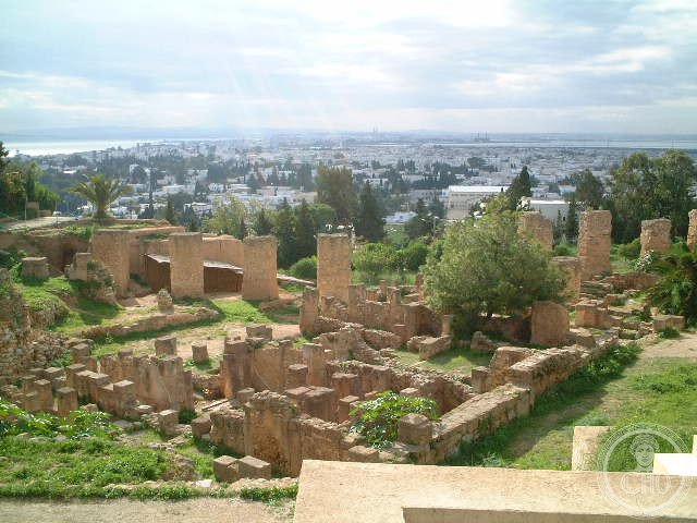
What you see
The archaeological site of Carthage is spread over a wide area without a central enclosure; visitors typically move between several discrete areas by car or the TGM suburban train. The Antonine Baths are the most architecturally impressive standing ruins: a forest of re-erected columns, the surviving basement walls of the main hall, and the view over the Gulf of Tunis from the headland make this the most photogenic site. The Punic Ports — the circular military harbour and the rectangular commercial harbour — are best understood from the Oceanographic Museum on the central island of the military harbour, where models reconstruct the original layout.
The Carthage National Museum on the Byrsa Hill (the original acropolis of the Phoenician city) has the best collection of Phoenician and Punic objects in the world, including tophet stelae, jewellery, masks, and pottery; the Byrsa Hill excavations have revealed a Punic residential quarter from the 4th–2nd century BC. The Tophet sanctuary, a 10-minute walk south, has a small open-air display of burial urns and stelae in situ; the atmosphere is unexpectedly affecting given the scale of the controversy about what the site represents.
Practical information
- Admission: a combined ticket (approximately TND 12–15) covers the main sites: Antonine Baths, Byrsa/National Museum, Tophet, Punic Ports, Theatre, and Villas; individual sites have separate entry but the combined ticket is better value
- Getting there: TGM suburban train from Tunis Marine station to Carthage-Hannibal, Carthage-Présidence, or Carthage-Dermech stops (30 minutes, TND 1.5); the train runs every 30 minutes; the different sites are spread along a 3 km coastal strip, navigable on foot between the TGM stops
- When to go: the site is walkable in all seasons; avoid midday in July–August (extreme heat, little shade at the outdoor sites); the Antonine Baths and Tophet have no shade
- Sidi Bou Said: the blue-and-white hilltop village 3 km east of Carthage (one TGM stop) is a natural extension of the Carthage visit; 30 minutes to walk the village lanes; the views over the Gulf of Tunis and to Cap Bon are superb
Getting there
Tunis-Carthage International Airport (TUN) is 8 km from central Tunis and 12 km from the Carthage site; taxi direct to Carthage (30 minutes). TGM suburban train from Tunis Marine station (central Tunis) to Carthage (30 minutes, multiple stops for different site areas). GPS: 36.8528, 10.3233.
Nearby
- Sidi Bou Said — the blue-and-white village on the cliff above the Gulf of Tunis, 3 km east; the most-photographed townscape in Tunisia; the Café des Nattes, dating from the early 20th century, was frequented by Simone de Beauvoir, André Gide, Paul Klee, and August Macke; one TGM stop from Carthage
- Bardo National Museum (Tunis) — the finest collection of Roman mosaics in the world; housed in a former palace 10 km west of Carthage; essential context for the Roman layer of the Carthage site; several hours; closed Mondays
- Dougga (Thugga) — the best-preserved Roman town in Africa, 110 km south-west of Tunis; the Capitol temple (166 AD) and the theatre (168 AD) are both substantially intact; UNESCO WHS; a half-day or full-day excursion from Tunis
Sources
- Wikipedia, Carthage, accessed June 2026
- UNESCO, Archaeological Site of Carthage, WHS reference 37, inscribed 1979
- Dexter Hoyos, Carthage’s Other Wars: Carthaginian Warfare Outside the Punic Wars, Pen & Sword Military, 2019
- Richard Miles, Carthage Must Be Destroyed: The Rise and Fall of an Ancient Civilization, Allen Lane, 2010 — the best modern synthesis for the general reader
Find it on the map
See this place and what’s around it →📷 Diventa un fotografo di Cultural Heritage Online
Condividi le tue foto dei luoghi: restano pubblicate con la tua firma come autore. Più vengono viste, più ti fai conoscere — e presto un concorso premierà le foto più apprezzate.
Accedi o registrati gratis per aggiungere una foto