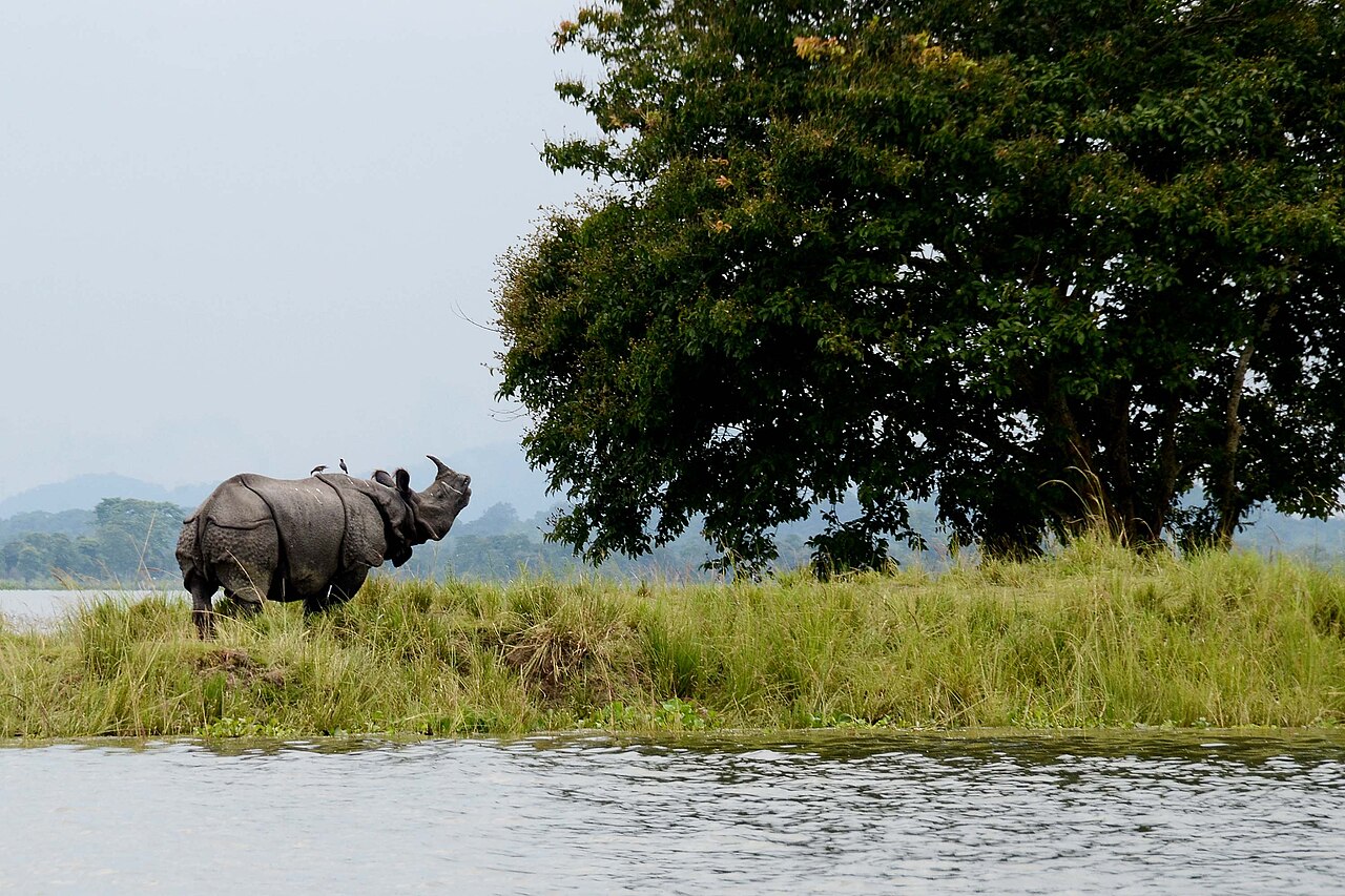
Kaziranga National Park in Assam holds 2,613 greater one-horned rhinoceros as of the 2022 census — 68 percent of the entire world population of the species — on 430 sq km of Brahmaputra river floodplain protected since 1905. It was created as a reserved forest because Lady Curzon, wife of the Viceroy of India, visited in 1904 and saw no rhinos at all; alarmed, she convinced her husband to gazette the area before the animals were hunted to regional extinction. UNESCO listed the park in 1985; it also holds the highest tiger density of any reserve on earth, 14 tigers per 100 sq km.
How a viceroy’s wife’s empty safari saved the world’s rhino population Kaziranga, Assam, National Highway 37
In 1904, Mary Curzon visited the area that is now Kaziranga on the recommendation that it was good wildlife country. She returned to Calcutta having spotted no rhinos. Her account of the visit, relayed through Lord Curzon to the colonial administration in Assam, triggered an unusually direct chain of government action: the area was gazetted as a reserved forest in 1905, with access restrictions on hunting. The decision was timely. Greater one-horned rhinoceros (Rhinoceros unicornis) had been hunted across their former range from Nepal to Assam for their horns, which commanded consistent prices in traditional medicine markets across East Asia. By the early 20th century, the animals had been eliminated from most of their former habitat; only a few pockets in the Terai grasslands and the Brahmaputra floodplain retained viable populations.
The 1905 reservation was formalized progressively: a game reserve in 1916, a wildlife sanctuary in 1950, a national park in 1974. UNESCO inscription followed in 1985. Through this period the rhino count moved from near-extinction-level numbers in the early 20th century to the current population of over 2,600 — a recovery that is widely cited in conservation literature as one of the most successful large mammal recoveries in Asia. The 2022 census figure of 2,613 represents 68 percent of the world’s total R. unicornis population.
The park’s terrain is determined by the Brahmaputra, one of the world’s largest rivers by discharge volume, which runs along Kaziranga’s northern boundary. The annual monsoon flood — typically June to September — inundates roughly 70 percent of the park. Animals move upward onto slightly elevated ground within the park, or cross National Highway 37 (which runs along the southern boundary) to reach the Karbi Anglong hills. The highway crossing is a documented mortality risk: vehicle collisions kill animals each year during flood evacuations, and the Forest Department coordinates with state authorities to impose speed limits and vehicle restrictions during flood season. The Karbi Anglong hills, privately managed forest land to the south, function as an unofficial buffer zone; conservationists have campaigned for formal corridor status.
Beyond rhinos, the population count at Kaziranga includes 116 tigers, approximately 1,300 Asian elephants, the endangered Eastern swamp deer (barasingha), wild water buffalo, Hoolock gibbons (the only ape species native to India), and Ganges river dolphins in the Brahmaputra itself. The tiger density of 14 per 100 sq km is the highest of any tiger reserve in the world — higher than Ranthambore, higher than Corbett. The tigers are less visible than the rhinos because they use denser reed beds and woodland patches, but camera trap data confirms the figure.
Anti-poaching policy at Kaziranga has been contentious internationally. The park operates under a shoot-on-sight directive for armed intruders, a policy that has been in place in various forms since the 1990s. Between 2015 and 2020, more than 200 suspected poachers were killed by forest guards. Human rights organisations have raised objections; park management and the Indian government have defended the policy by citing the recovery of the rhino population as evidence that aggressive deterrence works. The debate is unresolved.
Tea estates, Manas, and the forest with four big cat species Manas 200km west / Namdapha 400km east
Kaziranga’s northern boundary is not a fence or a river — it is a row of Assam tea gardens. The tea estates that produce what is sold internationally as Assam tea (a full-bodied black tea with a distinctive malty character, grown at low elevation in humid conditions) begin where the national park’s buffer zone ends. Some of these gardens, particularly along the northeastern perimeter, have been managed with wildlife corridors in mind — reduced pesticide use, maintenance of tree cover along estate margins — creating a landscape where elephants and rhinos cross between the park and the estate land seasonally. The visual experience of watching a one-horned rhinoceros graze against a background of tea bushes is specific to Kaziranga and nowhere else.
Manas Wildlife Sanctuary, 200km west of Kaziranga, is the other UNESCO World Heritage Site in Assam and is directly linked to Kaziranga in conservation terms. When Manas was devastated by Bodo separatist insurgency in the 1990s — with rhinos hunted to near-zero and forest staff evacuated — the recovery programme beginning in 2008 depended on translocation of animals from Kaziranga’s healthy population. Greater one-horned rhinos were captured at Kaziranga using veterinary immobilisation and transported to Manas to restart a breeding population. By 2022 Manas had approximately 50 rhinos descended from this reintroduction. The two parks form a connected conservation landscape across Assam, and both are UNESCO-listed under the same 1985 cycle.
Namdapha National Park, 400km east of Kaziranga in Arunachal Pradesh near the Chinese border, is not a UNESCO site but holds a wildlife combination found nowhere else on earth: four species of large cat (tiger, leopard, clouded leopard, and snow leopard) coexist in a single contiguous landscape, along with Asian elephant, red panda, Hoolock gibbon, and an extraordinary diversity of bird species. It is one of the most biologically diverse protected areas in Asia. Access requires an Inner Line Permit (ILP) from the Arunachal Pradesh government, limiting visitor numbers substantially. For serious wildlife travellers who have covered Kaziranga and Manas, Namdapha represents a logical extension, though its infrastructure is rudimentary compared to the well-developed tourism facilities at Kaziranga.
Kaziranga’s own visitor infrastructure is extensive by Indian wildlife reserve standards. Multiple safari zones — Western (Bagori), Central (Kohora), Eastern (Agoratoli), and Burapahar — are managed by the Forest Department with scheduled jeep and elephant safaris. The park’s proximity to Guwahati (the largest city in northeast India, with an international airport) and the NH37 highway running along its southern edge make logistics straightforward. Jorhat, to the east, provides an alternative access point and is closer to some of the park’s best rhino grasslands.
Practical information
Kaziranga National Park’s main gateway is Kohora, on National Highway 37, approximately 220km east of Guwahati (4-hour drive) and 90km west of Jorhat. Guwahati Lokpriya Gopinath Bordoloi International Airport has direct flights to Delhi, Mumbai, Kolkata, and other Indian cities; several airlines also operate international routes. From Guwahati airport, a pre-booked taxi to Kohora takes 4–4.5 hours. Jorhat airport is closer to the Eastern Range (40km) but has fewer flight connections.
The park is open from November 1 to April 30; it is closed from May through October when the Brahmaputra floods make the interior inaccessible. Jeep safaris depart from all four ranges in morning (6:00–9:00) and afternoon (14:00–17:00) slots; booking at least 2 days in advance is advisable in peak season (December–February). Elephant safaris, which access dense reed-bed areas that jeeps cannot enter, are limited in number and should be booked through the Forest Department as soon as arrival dates are fixed. Entry fees (2024): foreign visitor jungle fee ₹650 per zone, plus vehicle fees. Accommodation ranges from budget lodges at Kohora to mid-range and upscale wildlife resorts along the NH37 corridor; many resorts have their own naturalist guides and organise park permits.
Rhino sightings are close to guaranteed in the Central Range (Kohora) during dry season mornings. Tiger sightings require luck regardless of zone.
Frequently Asked Questions
How did Kaziranga achieve the world’s highest tiger density?
Kaziranga’s density of 14 tigers per 100 sq km — the highest recorded for any tiger reserve — results from a combination of factors that are unusually favourable and have been consistently maintained. The prey base is exceptional: the park supports large populations of water buffalo, swamp deer, hog deer, and wild boar, all of which are substantial tiger prey species. The Brahmaputra floodplain grass-forest mosaic, periodically refreshed by monsoon flooding, produces enormous quantities of vegetation that sustains the herbivore populations. Tigers do not need to range widely when prey is dense, so more animals can occupy the same territory. The park’s anti-poaching regime is among the most strictly enforced in India — shoot-on-sight orders for armed intruders have reduced poaching mortality significantly compared to parks with lighter enforcement. The park boundary, while small in total area (430 sq km core zone), is effectively defended and has been for decades. For comparison, Ranthambore — a famous tiger reserve in Rajasthan — has roughly 4–5 tigers per 100 sq km. Jim Corbett National Park in Uttarakhand has 6–7 tigers per 100 sq km. Kaziranga’s figure of 14 per 100 sq km is more than double the next-highest figure for a major reserve. The implication for visitors is that the probability of a tiger sighting, while never guaranteed because tigers use dense cover, is substantially higher at Kaziranga than at most other reserves in India. Camera traps operated by the Wildlife Institute of India have documented tigers moving through every zone of the park.
Why does the annual Brahmaputra flood benefit the park rather than harm it?
The Brahmaputra is one of the largest rivers in Asia by water discharge, and its annual monsoon flood is not an exceptional event at Kaziranga — it is a recurring ecological process that the park’s ecosystems evolved to accommodate. The flood does three things that benefit the long-term ecology of the reserve. First, it deposits nutrient-rich silt across the grasslands, fertilising the tall elephant grass (Saccharum spontaneum, Imperata cylindrica) that is the foundational habitat for rhinos, deer, and elephants. Without periodic silt deposition, these grasslands would become less productive and woodland would encroach. Second, the flood cycle creates and refreshes the shallow seasonal wetlands within the park that support fish populations, which in turn sustain otters, dolphins, fishing cats, and birds. Third, the flood mobilises and flushes out snares, traps, and temporary encroachment structures set by poachers, creating a natural enforcement cycle that supplements human patrols. The costs of the flood are real: animals crossing the highway suffer vehicle collision mortality, and if flood waters are unusually high — as has occurred more frequently in recent years, possibly linked to altered monsoon patterns upstream — animals can drown or become stranded. Park management monitors flood levels continuously and coordinates with the state government to manage highway traffic during the period when animals cross in numbers. The net ecological assessment is that the flood is integral to what makes Kaziranga capable of supporting the densities it does; suppressing it would harm the park.
What is the difference between the four safari zones at Kaziranga, and which one should first-time visitors choose?
Kaziranga’s four safari ranges have distinct characteristics reflecting the park’s varied terrain. The Central Range (Kohora) is the most visited and offers the broadest mix of habitats within a compact area — open grassland, woodland patches, wetland areas, and the Diphlu River. Rhino sightings are most reliable here because the open terrain allows clear viewing and the animal density is highest. First-time visitors should start here. The Western Range (Bagori) is known for large elephant herds and good tiger sighting probability, particularly around waterholes in the dry months of March and April. It is also the departure point for elephant safari rides, which enter reed-bed areas that jeeps cannot penetrate. The Eastern Range (Agoratoli), accessible from Kaziranga’s eastern end near Jorhat, has the least visitor pressure and is preferred by photographers seeking uncrowded conditions; rhinos and wild buffalo are common here. The Burapahar Range is on slightly higher ground in the south of the park, with a different vegetation character — more hill forest, less grassland — and is better for seeing Hoolock gibbons, leopard cat, and woodland species. It is the least visited of the four zones. A three-day visit that covers Central and Western on the first two mornings, with an elephant safari on one afternoon, gives a comprehensive picture. Booking the Eastern range requires a longer stay in the park or a willingness to drive to the far end of the highway corridor before the 6:00 AM departure.