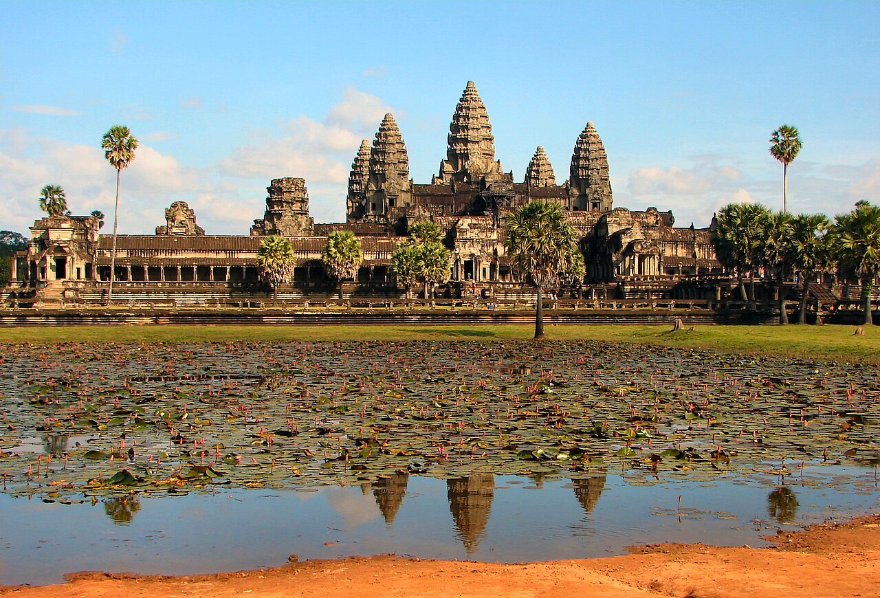
Angkor Wat, constructed between 1113 and 1150 CE under Khmer king Suryavarman II, covers 162.6 hectares and remains the largest religious monument ever built. Its outer moat stretches 190 metres wide and runs nearly 5.5 kilometres around the perimeter. The site sits within the broader Angkor Archaeological Park — a UNESCO World Heritage Site since 1992 — which holds the densest concentration of monumental architecture in Southeast Asia.
Angkor Thom and the Monuments of the Khmer Capital 2 km north of Angkor Wat
One kilometre north of Angkor Wat’s north gate lies the walled city of Angkor Thom, built in the late 12th century by Jayavarman VII after the Cham forces sacked the previous capital in 1177. The city wall encloses nine square kilometres; at its peak, estimates based on water-management infrastructure and rice cultivation capacity suggest Angkor supported a population of up to one million people — making it one of the largest pre-industrial urban centres on Earth.
At the geographic centre of Angkor Thom stands the Bayon, the state temple of Jayavarman VII. Its 54 towers carry 216 large stone faces — traditionally interpreted as the bodhisattva Avalokiteshvara or as a composite portrait of Jayavarman VII himself. Scholars continue to debate the precise iconography, but the sheer scale of the sculptural programme is undisputed: over 11,000 figures appear across 1.2 kilometres of bas-relief galleries within the Bayon alone.
The Terrace of the Elephants, running 350 metres along the eastern edge of the royal palace precinct, was used as a platform for public ceremonies and the review of returning armies. Its retaining walls are carved with elephants in procession and garudas clutching nagas. Immediately to its north stands the Terrace of the Leper King, a double retaining wall decorated with seven tiers of relief carvings depicting apsaras (celestial dancers), nagas, and figures of the underworld.
Ta Prohm, southeast of the Bayon, was built by Jayavarman VII as a Buddhist monastery and university beginning around 1186 CE. Its foundation stele records that the complex housed 12,640 people including 18 high priests and 615 dancers. Unlike most Angkor monuments, Ta Prohm was left largely uncleared when French conservation teams began systematic work in the early 20th century: a 1908 decision by the École française d’Extrême-Orient preserved the site’s mature silk-cotton and strangler fig trees growing through and over the stone galleries, both as a scientific experiment in structural co-existence and as an aesthetic demonstration of nature reclaiming architecture. The trees are now so structurally integrated with the stonework that removal would cause significant collapse.
The hydraulic network of Angkor — consisting of reservoirs (baray), canals, and moats — was the engineering achievement that sustained the city’s population. The West Baray measures 8 km by 2.1 km and still holds water. Recent LiDAR surveys conducted between 2012 and 2015 revealed a dense grid of urban infrastructure extending beyond the mapped temple zone, confirming that the ceremonial core was surrounded by a substantial inhabited city.
Preah Vihear and Sambor Prei Kuk: Border Dispute and Pre-Angkor Origins Preah Vihear 240 km north; Sambor Prei Kuk 170 km southeast
Prasat Preah Vihear occupies a 525-metre cliff edge on the Dangrek Escarpment, on the border between Cambodia and Thailand. The temple was built over several centuries beginning in the 9th century, with major construction phases under Suryavarman I in the early 11th century and Suryavarman II in the 12th. It faces north toward Thailand despite being administered by Cambodia — a geographic and political anomaly that led to a prolonged territorial dispute. The International Court of Justice ruled in Cambodia’s favour in 1962, awarding sovereignty over the temple and its immediate promontory to Cambodia. A second ICJ ruling in 2013 clarified the boundaries of the 1962 judgment. The temple was inscribed on the UNESCO World Heritage List in 2008 amid renewed military clashes between Cambodian and Thai forces that resulted in casualties and temporary evacuations of nearby villages.
The site’s elevated position provides unobstructed views across the Cambodian plain 525 metres below. Four gopuras (gateway pavilions) connect via a 800-metre processional causeway that ascends the cliff in a series of terraced platforms. The sanctuary’s setting is structurally and ritually distinct from Angkor: rather than a lowland hydraulic city, Preah Vihear is a mountain sanctuary, oriented toward a natural peak considered sacred in pre-Angkorian Khmer cosmology.
Southeast of Angkor lies Sambor Prei Kuk, inscribed as a UNESCO World Heritage Site in 2017. It served as the capital of the Chenla kingdom (the predecessor polity to the Khmer Empire) between the 6th and 8th centuries CE, under rulers including Isanavarman I, who made it his capital around 612 CE. The site contains more than 100 brick-tower temples across three main groups — north, central, and south — spread through a forested area of approximately 2,500 hectares. The brick construction technique and decorative vocabulary used at Sambor Prei Kuk directly influenced later Khmer architecture, including the tower forms and lintel carvings that became standard at Angkor. Some medallion reliefs at Sambor Prei Kuk represent the earliest known examples of certain iconographic types in mainland Southeast Asia.
The Tonle Sap lake, approximately 15 kilometres south of Angkor Wat, is the largest freshwater lake in Southeast Asia. During the monsoon season (June–October), the Mekong River reverses the flow of the Tonle Sap River, causing the lake to expand from roughly 2,500 square kilometres to as much as 16,000 square kilometres and increase in depth from 1 metre to 9 metres. This annual flood pulse deposits sediment across the surrounding floodplain and generates fish stocks that have sustained the population of the Angkor region for over a millennium. Khmer engineers adapted the lake’s flood dynamics into the baray system that irrigated the rice paddies feeding the Angkor urban population.
Practical information Siem Reap, northwestern Cambodia
Siem Reap International Airport serves direct routes from Bangkok, Singapore, Kuala Lumpur, Hanoi, and Ho Chi Minh City. The nearest major hub with intercontinental connections is Bangkok Suvarnabhumi (BKK), approximately 90 minutes by air. A three-day Angkor Archaeological Park pass (USD 62 as of 2024) covers all temples within the main complex including Angkor Wat, Bayon, Ta Prohm, and related structures. The pass is sold at the official ticket centre on the road to Angkor; entry without a pass results in immediate expulsion from the site.
The dry season (November–April) offers cooler temperatures and passable roads. Sunrise visits to Angkor Wat require arriving by 05:00; the reflection pool on the west approach fills with visitors quickly after dawn. The wet season (May–October) significantly reduces visitor density and turns the surrounding landscape green, but some outlying temple access tracks become difficult by vehicle. Currency is the Cambodian riel (KHR), though US dollars are accepted throughout Siem Reap and at all major tourist sites. Visas are available on arrival at Siem Reap Airport (USD 30, 30 days) or in advance via the official e-Visa portal.
Preah Vihear requires a separate road journey of approximately four hours from Siem Reap via Anlong Veng. A temple pass applies separately (approximately USD 10 as of 2024). Check current border conditions before travelling: sections near the Thai border have historically had access restrictions. Sambor Prei Kuk is reached via Kampong Thom town, roughly two hours southeast of Siem Reap, with the site entrance a further 30 minutes by road.
Frequently Asked Questions
How long did it take to build Angkor Wat, and who was responsible for its construction?
Angkor Wat was built over approximately 37 years, from around 1113 to 1150 CE, under the reign of Suryavarman II, a Khmer king who unified the empire after a period of succession conflict. The temple functioned simultaneously as a state temple, a royal mausoleum, and a representation in stone of Mount Meru, the cosmological centre of the Hindu universe. Its orientation toward the west — unusual for Khmer temples, which typically face east — is associated with Vishnu (to whom the temple is dedicated) and with funerary ritual. The construction required an estimated 5 to 10 million sandstone blocks, each weighing between 1.5 and 3 tonnes, transported from Phnom Kulen quarries approximately 40 kilometres to the northeast via a network of canals. No written construction records survive from the Khmer Empire, so the chronology is reconstructed from inscriptions at other sites and stylistic analysis of the reliefs. The 600-metre-long bas-relief galleries on the outer wall of the third enclosure depict scenes from the Mahabharata and Ramayana, as well as military processions believed to show Suryavarman II himself reviewing his army — one of the few portrait-like representations of a Khmer king.
What is the significance of the 1908 French conservation decision at Ta Prohm?
When the École française d’Extrême-Orient began systematic clearance and restoration of the Angkor monuments in the early 20th century, the lead archaeologist Jean Commaille and subsequent conservators made a deliberate choice to leave Ta Prohm’s mature trees in place, rather than removing them as was done at Angkor Wat and the Bayon. The reasoning had both practical and philosophical dimensions. Practically, the roots of the silk-cotton trees (Ceiba pentandra) and strangler figs (Ficus gibbosa) had grown so deeply into the gallery walls and tower bases that removal would have caused structural collapse of sections already undermined by root pressure. Philosophically, French conservators of the period held a Romantic view of ruins as monuments to the passage of time, and Ta Prohm offered a visible record of organic processes overtaking built structures. The decision has become controversial in subsequent decades: arborists and structural engineers have documented ongoing damage caused by root expansion, and some scholars argue that the trees will eventually destroy what they currently define. UNESCO and the Archaeological Survey of India (which has led restoration work at Ta Prohm since the 1990s) continue to debate the intervention threshold — when root damage justifies tree removal to preserve stone structure.
How disputed is the border situation at Preah Vihear, and is the site safe to visit?
The legal dispute over Preah Vihear was settled definitively by the International Court of Justice in its 1962 ruling (Temple of Preah Vihear, Cambodia v. Thailand) and its 2013 clarificatory judgment. Thailand accepted the 2013 ruling without appealing further. The temple is administered by Cambodia and is legally within Cambodian territory. However, military confrontations occurred between 2008 and 2011 after the temple’s UNESCO inscription, when Thai nationalist groups opposed the listing and Thai military units occupied areas near the temple. Clashes in 2011 resulted in deaths on both sides and displacement of approximately 10,000 Thai civilians from border villages. Since 2013, the border has been calm and the temple has been open to visitors on the Cambodian side. The approach from Thailand — via the Kantharalak district of Sisaket Province — was historically the more convenient access route but requires crossing the border, which involves administrative procedures that change periodically. Visitors from Cambodia travel via Anlong Veng to the base of the escarpment; a cable car or steep road provides access to the summit. It is advisable to check the current status of the Thai approach before planning a trip.