
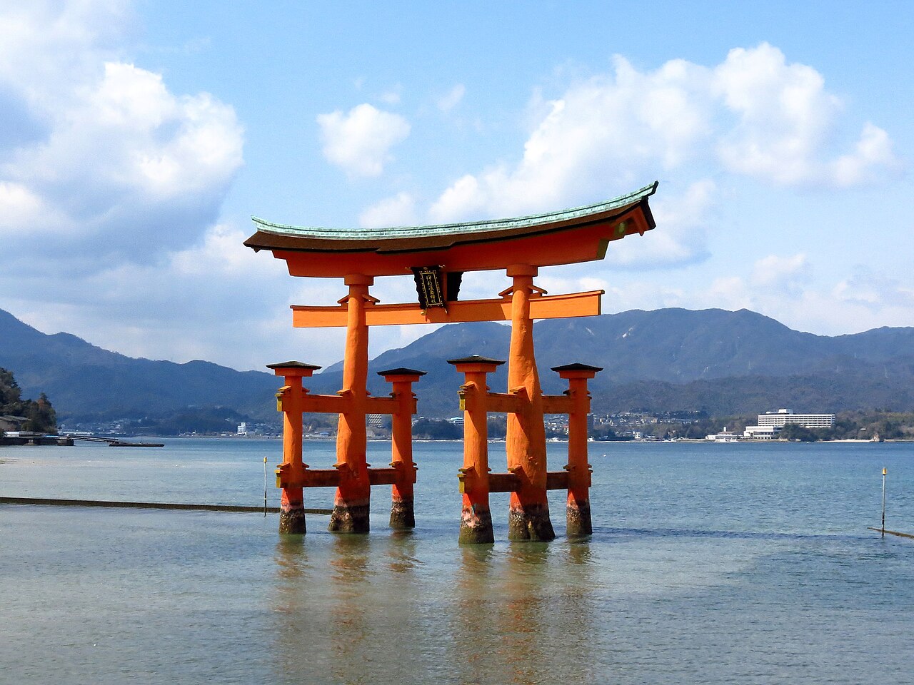
The nearest World Heritage site to Itsukushima Shinto Shrine is the Hiroshima Peace Memorial (Genbaku Dome), 16 km away in a straight line. The next two, the Sites of Japan’s Meiji Industrial Revolution and the Iwami Ginzan Silver Mine, lie 76 and 88 km off. Itsukushima itself is a Shinto shrine on an island in the Seto Inland Sea, an island the local tourist association calls Miyajima. Its halls and corridors stand where the tide ebbs and flows, with a forested mountain behind them.
The World Heritage sites within reach of Itsukushima Shrine
The distances below are straight lines between the reference points that UNESCO publishes for each property, measured to the nearest component of a serial site. They show what is close. They do not give road, rail or ferry times.
| Site | Country | Distance | Inscribed | Type |
|---|---|---|---|---|
| Hiroshima Peace Memorial (Genbaku Dome) | Japan | 16 km | 1996 | Cultural |
| Sites of Japan’s Meiji Industrial Revolution: Iron and Steel, Shipbuilding and Coal Mining | Japan | 76 km | 2015 | Cultural |
| Iwami Ginzan Silver Mine and its Cultural Landscape | Japan | 88 km | 2007 | Cultural |
| Sacred Island of Okinoshima and Associated Sites in the Munakata Region | Japan | 175 km | 2017 | Cultural |
| Himeji-jo | Japan | 226 km | 1993 | Cultural |
| Hidden Christian Sites in the Nagasaki Region | Japan | 267 km | 2018 | Cultural |
Only the Peace Memorial shares Itsukushima’s inscription year, and little else. The Genbaku Dome is a 0.4-hectare structure that UNESCO describes as the only one left standing in the area where the first atomic bomb exploded on 6 August 1945. A quieter link runs to Okinoshima, 175 km away. The Main Shrine at Itsukushima is dedicated to the three Munakata goddesses, while UNESCO describes Okinoshima as integrated within the Grand Shrine of Munakata and still considered sacred. Iwami Ginzan, a mining landscape worked between the 16th and 20th centuries, counts shrines among its components.
Why was a shrine built out over the sea?
UNESCO points to the setting first. The buildings stand on the sea, with the architecture at the centre, the sea in the foreground and the mountains behind. That trinity, it says, became a Japanese standard of beauty against which other scenic views are understood.
The shrine’s own history gives a founding story. Saeki no Kuramoto, who governed the island, received an oracle, sailed round it with the deities and chose the spot where the tide ebbs and flows. According to an ancient record this happened in 593. In 1168 Taira no Kiyomori rebuilt the shrine in the shinden-zukuri style, the manner of noble residences of the day.
The reason for building over water is uncertain. The Miyajima Tourist Association offers two guesses: a version of the mythical Dragon Palace, since the enshrined goddess is a sea goddess, or an expression of Pure Land belief. Whichever it was, it adds, the result combines human craftsmanship with nature.
How does a wooden shrine last in tidal water?
Not without repair. The tourist association records fires in 1207 and 1223 and typhoon damage in 1325. It dates the present main sanctuary to 1571, after Mori Motonari’s victory at the Battle of Itsukushima in 1555 had restored the shrine’s fortunes. UNESCO notes that the buildings were reconstructed twice, in a scrupulously accurate manner that preserved the styles of the late 12th to early 13th centuries.
The carpentry allows for the water. The corridors have small gaps between the floorboards to relieve the pressure of the sea at high tide, and the shrine asks visitors to wear shoes that will not catch in them. The Miyajima association adds that no nails hold the boards and that the gaps also drain rain. Posts standing in water decay easily, so the upkeep includes clearing algae from the beach and levelling the sandbar.
The owner employs a qualified conservation architect, UNESCO states, and every building has automatic fire alarms, hydrants and lightning arresters. All of them are wood.
How does the O-torii stand without being fixed to the seabed?
It is held down by its own weight. The Miyajima Tourist Association gives the gate’s height as about 16.8 metres and says it is supported by its own weight. The present gate is the ninth, erected in 1875. It follows the four-pillar ryobu style, said to have been adopted when the gate was rebuilt in 1547, and was designated an Important Cultural Property on 29 March 1952.
The gate also has a ceremonial role. At the Kangensai, the shrine’s largest annual festival, held on the night of 17 June by the lunar calendar, decorated boats carrying orchestras pass through the torii and into the enclosure in front of the Main Shrine.
Frequently Asked Questions
Which UNESCO World Heritage sites are near Itsukushima Shinto Shrine?
The Hiroshima Peace Memorial (Genbaku Dome) is nearest, 16 km away in a straight line. Next come the Meiji Industrial Revolution sites (76 km), Iwami Ginzan Silver Mine (88 km), Okinoshima and the Munakata sites (175 km), Himeji-jo (226 km) and the Nagasaki Hidden Christian Sites (267 km).
Why is Itsukushima Shrine built over the water?
The reason is uncertain. According to an ancient record the shrine’s founder chose a place where the tide ebbs and flows, in 593. The Miyajima Tourist Association suggests the design imitates the Dragon Palace of the sea goddess, or expresses Pure Land belief. UNESCO stresses the result: a trinity of architecture, sea and mountains.
How tall is the O-torii gate, and is it fixed to the seabed?
The Miyajima Tourist Association gives its height as about 16.8 metres. It is supported by its own weight rather than fixed in place. The present gate is the ninth to stand there and was erected in 1875. It has been an Important Cultural Property since 1952.
When did Itsukushima Shinto Shrine become a World Heritage site?
UNESCO inscribed it in 1996 under criteria (i), (ii) and (iv). The property covers 431.2 hectares of the island, with a buffer zone of 2,634.3 hectares that includes the rest of the island and part of the sea in front of the shrine. It is not on the List of World Heritage in Danger.
Sources
- UNESCO World Heritage Centre, Itsukushima Shinto Shrine (inscribed 1996). https://whc.unesco.org/en/list/776/
- Itsukushima Shrine, official website, History. https://www.itsukushimajinja.jp/en/history.html
- Itsukushima Shrine, official website, Route (visitor notice on the corridors). https://www.itsukushimajinja.jp/en/route.html
- Miyajima Tourist Association, Itsukushima Shrine. https://www.miyajima.or.jp/english/spot/spot_itsukushima.html
- Miyajima Tourist Association, O-torii Gate. https://www.miyajima.or.jp/english/spot/spot_ootorii.html
- UNESCO World Heritage Centre, Hiroshima Peace Memorial (Genbaku Dome) (inscribed 1996). https://whc.unesco.org/en/list/775/
- UNESCO World Heritage Centre, Sacred Island of Okinoshima and Associated Sites in the Munakata Region (inscribed 2017). https://whc.unesco.org/en/list/1535/
- UNESCO World Heritage Centre, Iwami Ginzan Silver Mine and its Cultural Landscape (inscribed 2007). https://whc.unesco.org/en/list/1246/
- UNESCO World Heritage Centre, Sites of Japan’s Meiji Industrial Revolution (inscribed 2015). https://whc.unesco.org/en/list/1484/
Spotted an error? Write to editorial@culturalheritageonline.com and we correct it the same day.

.jpg)