
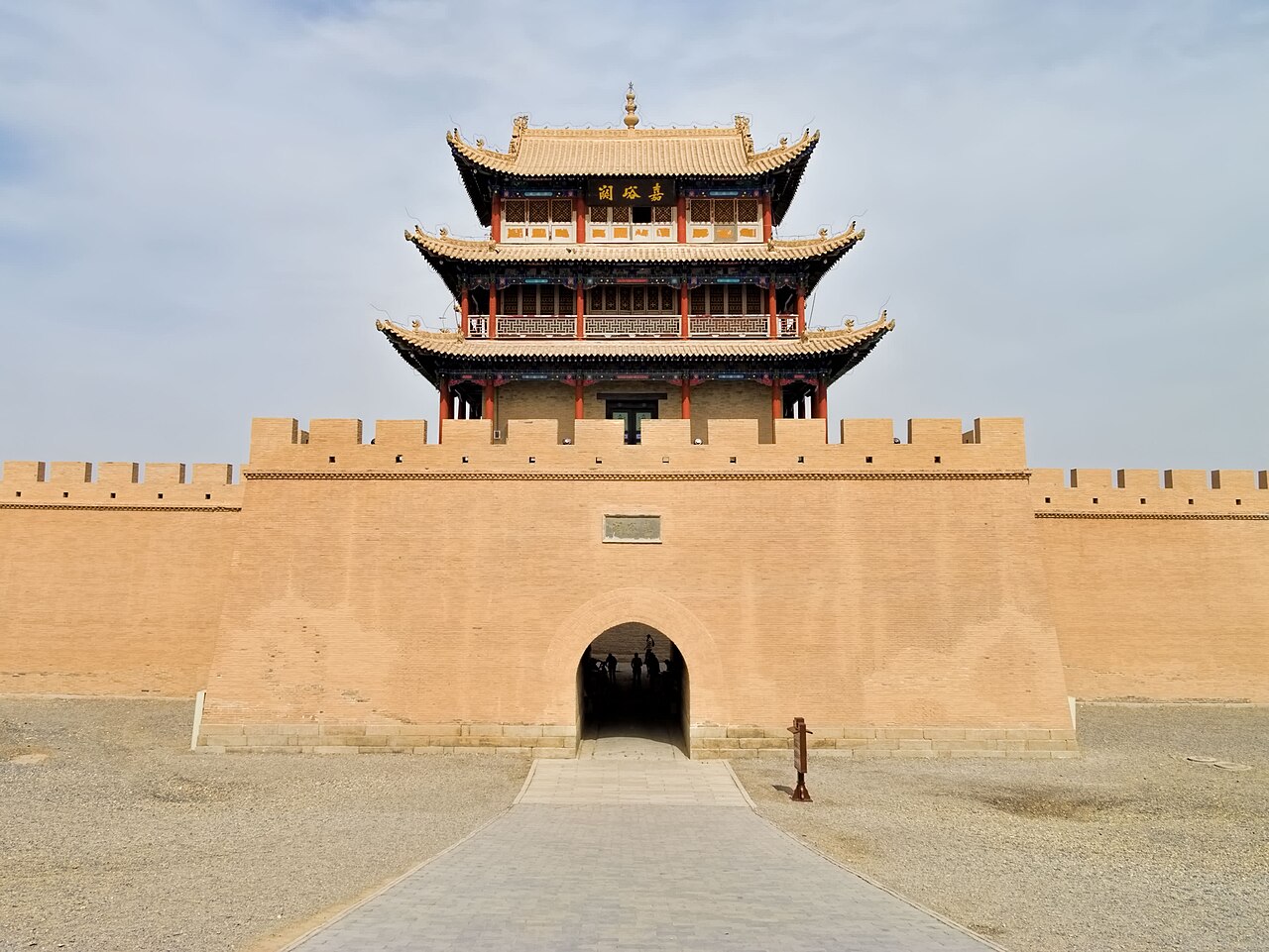
The Silk Roads: the Routes Network of Chang’an-Tianshan Corridor (UNESCO 2014) is a joint transnational inscription across China, Kazakhstan and Kyrgyzstan covering 33 component sites along approximately 5,000 kilometres of documented route. The inscription was the first World Heritage site to span three countries under a joint nomination; the component sites in China include palace complexes in Xi’an, Buddhist cave temples, Han-dynasty watchtowers and the Jiayuguan Fort at the western terminus of the Great Wall, where official passports were stamped for caravans departing from China between the 1370s and the 18th century. A beacon tower relay network along the Hexi Corridor could transmit a military signal from the frontier at Jiayuguan to the Han capital of Chang’an (Xi’an) within an estimated 24 hours.
Eastern anchor: Terracotta Army Xi’an and Yin Xu Anyang Terracotta Army 40 km east of Xi’an city centre, 30 min bus; Yin Xu 2,000 km east of Jiayuguan, 12h HSR via Xi’an
The Mausoleum of the First Qin Emperor, including the Terracotta Army pits, was inscribed as UNESCO World Heritage in 1987; it lies 40 kilometres east of the Xi’an city centre, approximately 30 minutes by tourist bus from Xi’an North or Xi’an Railway Station. Xi’an (Chang’an in its imperial designation) was the eastern starting point of the Chang’an-Tianshan Silk Road inscription, and the connection between the Qin imperial complex and the Silk Road is one of historical sequence: the Qin unification of China under the First Emperor (221 BCE) created the administrative and military conditions that made long-distance continental trade feasible under the succeeding Han dynasty (206 BCE–220 CE). The Han Emperor Wu, who dispatched the diplomat Zhang Qian westward in 138 BCE on what is often described as the opening of the Silk Road, was ruling from the same capital of Chang’an, 1.5 kilometres west of the Qin palace complex. The Terracotta Army’s three pits contain an estimated 8,000 figures across approximately 20,000 square metres of excavated floor area; only portions of Pit 1 (the main infantry formation) and Pit 2 (mixed cavalry and infantry) are currently open to visitors. The figures were discovered in 1974 by farmers drilling a well; systematic archaeological excavation began in 1975 and is still ongoing in Pit 3 and sections of Pit 1. The bronze chariots discovered in the western burial mound (1980) represent the highest level of bronze casting from the Qin period: Chariot 2 (the “Warm Chariot”) consists of 3,462 separate bronze parts assembled without modern tooling, with individual components weighing as little as 0.5 grams. The Silk Road inscription covers components within Xi’an itself (Han-dynasty palace sites Weiyang Palace and Changle Palace, Tang-dynasty imperial gardens at the Daming Palace) rather than the Terracotta Army, which belongs to the separate Qin Mausoleum inscription; visiting Xi’an therefore provides access to two separate UNESCO properties within the same city and the broader historical context for the Silk Road’s continental origins.
The Yin Xu inscribed site in Anyang, Henan Province, was inscribed as UNESCO World Heritage in 2006 and represents the pre-Silk Road civilisational foundation from which the Chang’an-Tianshan corridor ultimately grew. Anyang is approximately 2,000 kilometres east of Jiayuguan and reachable by high-speed rail in approximately 2 hours from Zhengzhou (itself 5.5 hours from Xi’an on the Xuzheng HSR). Yin Xu is the archaeological site of the late Shang dynasty capital (approximately 1300–1046 BCE), the oldest confirmed royal capital in China with a continuous, scientifically excavated archaeological record. The significance for Silk Road context is linguistic and administrative: the oracle bone script recovered from Yin Xu in over 150,000 inscribed bone and shell fragments is the earliest confirmed form of Chinese writing, pre-dating the Silk Road by approximately 1,000 years, and the administrative and ritual functions recorded in the oracle bones — royal divination, military campaigns, astronomical observations, agricultural records — represent the bureaucratic tradition that later enabled the Han dynasty to manage a 5,000-kilometre trade corridor across Central Asia. The Shang royal cemetery at Yin Xu, west of the Huan River, contains 13 large royal tombs (the largest measuring 19 metres deep with four entrance ramps) and approximately 2,500 smaller burial pits, many of which yielded mass human sacrifice deposits of between 10 and 400 individuals per pit. The Yin Xu Museum, opened in 2005 adjacent to the chariot burial site, displays original oracle bones, bronze ritual vessels (ding, gui and jue drinking vessels), bronze weapons, jade figurines and the skeletal remains of chariot horses in situ; it is one of the few Chinese archaeological museums where original burial goods are displayed in their excavated context rather than moved to a provincial museum.
West towards the desert: Mogao Caves Dunhuang and Xinjiang Tianshan Mogao Caves 25 km southeast of Dunhuang, 400 km west of Jiayuguan, 4h by road; Xinjiang Tianshan 500 km northwest of Urumqi, 6h+ by road
The Mogao Caves near Dunhuang in Gansu Province, inscribed as UNESCO World Heritage in 1987, are 400 kilometres west of Jiayuguan along the Hexi Corridor and approximately 25 kilometres southeast of Dunhuang city; the most practical access is by bus or taxi from Dunhuang (30 minutes). Dunhuang is reachable by air from Xi’an (2.5 hours) or by overnight train from Jiayuguan (8 hours). The Mogao cave complex consists of 735 caves cut into a sandstone cliff 1.6 kilometres long and 16 metres high on the south bank of the Dachuan River; 492 of the caves contain wall paintings, with a total painted surface area of approximately 45,000 square metres — the largest surviving concentration of Buddhist painting in the world. The earliest caves were cut in 366 CE, according to a founding inscription recorded in a Tang-dynasty text; the most intensive period of patronage ran from the 4th through the 11th centuries CE, spanning the Western Liang, Northern Wei, Western Wei, Northern Zhou, Sui, Tang, Five Dynasties and Northern Song periods. The connection between Mogao and the Silk Road inscription is direct: Dunhuang was the last Chinese city before the Gobi Desert on the northern and southern routes, and the cave complex was funded by merchants, military officials, pilgrims and local governors who used it as a place for prayer before or after the desert crossing. Cave 17, the “Library Cave,” was sealed around 1000 CE and rediscovered in 1900 CE by the monk Wang Yuanlu; it contained approximately 50,000 manuscripts and printed documents in Chinese, Tibetan, Sogdian, Uyghur, Sanskrit and other languages, representing the most significant cache of Silk Road textual documentation ever discovered. The British archaeologist Aurel Stein purchased approximately 10,000 items from Wang Yuanlu in 1907 for £130; they are now held at the British Library and the British Museum. The Dunhuang Academy, established in 1944, manages the site and issues a daily cap of 3,000 visitors divided between two timed entry slots; advance booking is essential during July and August. A separate ticket covers the replica caves at the Dunhuang Research Academy Visitor Centre, where high-resolution digital reproductions of eight caves are displayed in climate-controlled conditions without the visitor limits that apply to the original cliff site.
The Xinjiang Tianshan natural property, inscribed as UNESCO World Heritage in 2013, covers 606,833 hectares across four clusters in Xinjiang: the Tomur cluster (western Tianshan, highest peaks including Tomur/Tuomuer at 7,439 metres), the Bayanbulak cluster (alpine meadow at 2,400–2,600 metres, internationally important wetland for whooper swan and black-necked crane), the Kalajun-Kuerdening cluster (mixed conifer and broadleaf forest, glacial valleys) and the Bogda cluster (including Tianchi Lake at 1,928 metres elevation, 60 kilometres from Urumqi). The Tianshan is the geographic feature that the Silk Road routes had to circumnavigate: caravans travelling west from Dunhuang took either the northern route (skirting the Tianshan to the north, through what is now Urumqi and Ili) or the southern route (skirting the Tarim Basin to the south, through Kashgar), because the mountains themselves were impassable for laden camels except through specific high passes. The Silk Road inscription’s Central Asian component sites in Kazakhstan and Kyrgyzstan are located in the foothills and river valleys on the western and northern side of the Tianshan, confirming the mountain range’s role as the physical spine around which the route network was organised. Tianchi Lake in the Bogda cluster is the most accessible natural site in the Xinjiang Tianshan inscription: it is 1.5 hours by bus from Urumqi and has a paved visitor circuit of approximately 6 kilometres around the lake perimeter. The Tomur cluster requires a minimum 4-day expedition from Aksu city (4 hours from Urumqi by road) and is primarily visited by mountaineering expeditions; it is not accessible without a military permit due to its proximity to the Kyrgyzstan border. The best seasons for Bayanbulak are late May to June (whooper swan breeding season, spring meadow flora) and late August to September (autumn colours and lower visitor numbers).
Practical information
Xi’an is the logical base for the eastern Silk Road sites: it is directly served by high-speed rail from Beijing (4.5h), Shanghai (6h) and Zhengzhou (2h for Anyang connections). The Terracotta Army, the inscribed Han palace sites and the Tang Daming Palace are all within 40 kilometres of Xi’an city centre. Dunhuang and the Mogao Caves are best reached by air from Xi’an (2.5h); the Hexi Corridor train journey (Xi’an to Dunhuang via Jiayuguan) is approximately 20 hours and suited to travellers combining the route with overnight rail segments as part of a Silk Road itinerary. Jiayuguan Fort is 5 kilometres from Jiayuguan city and reachable by taxi or tourist bus; the fort and adjacent Great Wall museum visit takes approximately 3 hours. The Xinjiang sites (Tianchi Lake / Bogda cluster) require a separate trip to Urumqi; flights from Xi’an to Urumqi take 3 hours. June to September is the operational season for most Tianshan visitor facilities; July brings wildflower peak in the Bayanbulak meadows. Travellers entering Xinjiang should be aware that registration requirements and checkpoint procedures at road and rail entry points add time to all journeys; allow at minimum 3 extra hours at any Xinjiang border crossing. The Anyang/Yin Xu site is closed Mondays; the Mogao Caves require advance booking online via the Dunhuang Academy ticketing system for timed entry to the original cave sites.
Frequently Asked Questions
What was traded on the Silk Road and who were the main merchants?
The term “Silk Road” was coined by the German geographer Ferdinand von Richthofen in 1877 CE and was never used by the people who travelled the routes. The trade network it describes was active from roughly the 2nd century BCE to the 15th century CE, and the range of goods traded was far broader than silk. Silk was the primary Chinese export during the Han dynasty (206 BCE–220 CE), traded in bolts of standardised width (50 cm) and length (10 m) that functioned partly as currency: Han-dynasty government payrolls and diplomatic gifts were denominated in silk bolts. Westbound trade from China included porcelain (from the Tang dynasty onward), tea, lacquerware, iron, bronze mirrors, paper and printing technology. Eastbound trade into China included glassware (which China did not produce in quantity until the modern period), gold and silver coins, horses (the “heavenly horses” of Fergana Valley, Kyrgyzstan, were the object of a Han military campaign in 101 BCE precisely because Chinese cavalry needed them to match nomadic opponents), cotton textiles, spices, precious stones and, critically, Buddhist texts and religious objects. The merchants were primarily Sogdians — Iranian-speaking traders from the Samarkand and Turfan regions who maintained a diaspora merchant network from the 3rd to the 8th centuries CE, with communities documented at Dunhuang, Luoyang and Chang’an. The Library Cave at Mogao Caves preserved Sogdian merchant letters dated to approximately 313–314 CE, discovered by Aurel Stein, that describe trade conditions in Dunhuang and report on political instability in China. A single merchant rarely traversed the entire 5,000-kilometre route; goods typically changed hands multiple times at oasis towns, with different merchant communities dominating different segments of the route.
What is Jiayuguan Fort and why was it built at the western end of the Great Wall?
Jiayuguan Fort is a Ming-dynasty fortified gateway constructed from 1372 CE onward at the western terminus of the main Great Wall defensive line, occupying a 15-kilometre-wide bottleneck between the Qilian Mountains (rising to 5,547 metres) to the south and the Mazong Mountains to the north. The fort’s position was the result of geography: the Hexi Corridor narrows at Jiayuguan to a width that made it defensible with a wall across the full passage, whereas the broader open desert to the west made a continuous wall impractical. The fort comprises three concentric enclosures: an outer earth wall 733 metres long, a middle brick enclosure (the main garrison fort) 640 metres in circumference and 10.7 metres high with towers at the four corners, and an inner enclosure containing the garrison headquarters, granaries and a theatre stage. The inner fort is particularly well preserved because it was maintained through the Qing dynasty; the corner towers each have five roof levels in a progressively stepped form that allows defenders to fire through different angles. The fort’s function was administrative as well as military: officially registered caravans departing China required a laissez-passer (guandie) stamped at the fort’s outer gate before they could proceed westward. Exiles condemned to banishment beyond the Wall also passed through Jiayuguan; a literary convention developed around the image of the exiled scholar-official departing through the fort’s “Rouyuan” (Conciliating the Distant) outer gate, looking back at China. A local tradition recorded in Qing-dynasty gazetteers states that the fort’s architect calculated the exact number of bricks needed to construct the fort, requested that number from the imperial bureau, and when construction was complete had exactly one brick left over; that brick is displayed on a ledge above the western inner gate, where it has remained since the 15th century CE.
How did Buddhism travel from India to China along the Silk Road?
Buddhism entered China via the Silk Road in the 1st century CE, approximately 500 years after the religion’s founding in the Gangetic plain of India. The transmission occurred through multiple overlapping channels. Indian and Central Asian Buddhist monks travelled east with merchant caravans, establishing monastic communities in Kucha (Qiuci, in modern Xinjiang), Khotan (Hetian), Dunhuang and eventually Luoyang and Chang’an. The Han Emperor Ming’s envoys reportedly returned from an official mission to the western regions around 67 CE with Buddhist texts and two Indian monks on white horses, leading to the establishment of the White Horse Temple near Luoyang — one of the earliest Buddhist temples in China. The Kucha kingdom (modern Kuqa in Xinjiang) was particularly significant as a translation centre: the monk Kumaarajiiva (343–413 CE), born in Kucha to an Indian father and a Kuchean princess, was brought to Chang’an under military escort and produced 74 Chinese translations of Sanskrit Buddhist texts whose clarity and literary quality transformed Chinese Buddhist scholarship. The Mogao Caves at Dunhuang document the eastward progression of Buddhism in their artistic program: the earliest caves (late 4th–5th century CE) show strong Central Asian stylistic influences (the figural proportions, drapery conventions and colour palette of the Kizil cave complex in Kucha), while the Tang-dynasty caves (7th–9th century CE) show a fully Sinicised Buddhist art tradition. The Chinese monk Xuanzang made the reverse journey in 629–645 CE, travelling from Chang’an westward across Xinjiang, through the Tianshan passes, across Central Asia and through present-day Afghanistan to India, returning with 657 Sanskrit texts; his account, the “Great Tang Records on the Western Regions,” remains the primary documentary source for the political geography of 7th-century Central Asia.
Sources
- S1 — UNESCO World Heritage Centre — Silk Roads: the Routes Network of Chang'an-Tianshan Corridor (Ref. 1442) — https://web.archive.org/web/20230601000000/https://whc.unesco.org/en/list/1442/
- S2 — International Centre for Central Asian Studies — https://whc.unesco.org/en/list/1442/
- S3 — Kuhn, Dieter. <em>The Age of Confucian Rule: The Song Transformation of China</em>. Harvard University Press, 2009. ISBN: 978-0-674-03661-1.
Spotted an error? Write to editorial@culturalheritageonline.com and we correct it the same day.
.jpg)