The Tadrart Acacus is a 350-kilometre sandstone massif in southwestern Libya’s Fezzan desert, near the Algerian border, carrying thousands of rock paintings that span approximately 14,000 years of human presence. The paintings document four successive cultural periods — from the oldest known large-figure art in North Africa through the Green Sahara pastoral era to the camel age — making this the most complete pictorial record anywhere of the Sahara’s transformation from habitable landscape to desert. UNESCO inscribed it in 1985; the site has been on the List of World Heritage in Danger since 2016 due to Libya’s armed conflict.
Fourteen thousand years of painting, four worlds in sequence Fezzan desert, southwestern Libya, near the Algerian border south of Ghat
The paintings of the Tadrart Acacus are not a homogeneous body of work. They accumulate across the sandstone walls, ceilings and sheltered overhangs of the massif in visible stratigraphic layers, and specialists have identified four distinct cultural periods separated by shifts in subject matter, style and the animals portrayed — a pictorial record that aligns precisely with what geology and palaeoclimatology have established about the Sahara’s past.
The Roundhead period (approximately 12,000 to 6,000 BCE) produced the oldest and largest figures in the Acacus. The bodies are massive, often several metres high, and the heads are absent, globular, or rendered with mask-like featurelessness. The subject matter is frequently abstract or ambiguous — human-animal composites, floating figures, entities that resist ethnographic classification. Many researchers associate this period with shamanic or trance-related imagery, analogous to the altered-state interpretations proposed for southern African San rock art. Whatever the precise ritual context, the Roundhead painters were working during a period when the Sahara, though already arid in stretches, was more permeable to movement and settlement than it would become later.
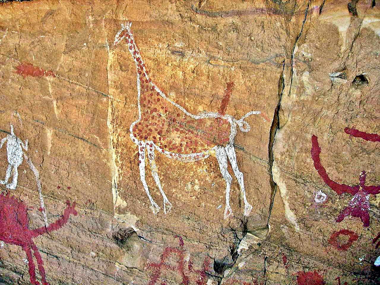
The Pastoral or Bovidian period (approximately 6,000 to 2,000 BCE) corresponds to the African Humid Period, when orbital forcing — a shift in Earth’s axial tilt and the precession of the equinoxes — redirected monsoon precipitation northward, bringing seasonal rains deep into what is now the central Sahara. The Acacus paintings from this phase show cattle, sheep and goats herded by people in domestic scenes of extraordinary vividness. The animals are painted in naturalistic profile with careful attention to coat markings and body weight. More striking are the species that are now climatically impossible here: hippopotamuses, Nile crocodiles and painted fish appear on rock faces that today overlook bare gravel plains receiving less than 10 millimetres of rainfall annually. This is not artistic invention. These animals lived here. The Acacus paintings are eyewitness testimony to a Sahara with perennial watercourses and wetland margins.
The Horse period (approximately 2,000 to 500 BCE) documents the arrival of the horse and, crucially, the chariot. The chariot images in the Acacus correspond to what French prehistorian Henri Lhote called the “chariot routes” across the Sahara — a network of rock art sites from Morocco to the Fezzan that traces roughly what would later become trans-Saharan trade corridors. The horses depicted are small and fine-boned. Whether chariots were practical transport vehicles or prestige objects associated with Mediterranean elites remains debated, but their presence confirms sustained contact between the Fezzan and the northern Mediterranean coast.
The Green Sahara in the rock face: reading the climate archive Nearest town Ghat, approximately 250 km south of Ubari; access from Sabha
The fourth and final cultural period at the Acacus — the Camelid period (approximately 500 BCE to 700 CE) — records the completion of the drying. Camels replace horses as the dominant pack and riding animal, which is climatologically precise: the dromedary camel became the standard Saharan transport animal only once the desert had dried sufficiently that horses could no longer be reliably watered on long-distance routes. The Camelid period paintings are often executed in a schematic style, with less investment in naturalistic detail than the Bovidian phase — a contraction of artistic ambition that may reflect smaller, more mobile communities adapted to extreme aridity rather than the larger sedentary or semi-sedentary pastoral populations of the Green Sahara.
The Tadrart Acacus is geologically inseparable from Algeria’s Tassili n’Ajjer, inscribed by UNESCO in 1982 and considered a dual cultural and natural site. Both are parts of the same ancient sandstone plateau, eroded over millions of years into the spectacular formations — mushroom rocks, natural arches, canyon corridors — that characterise the region. The administrative border between Libya and Algeria cuts across a unified geological and cultural landscape. The Tassili paintings include the famous Jabbaren and Sefar sites with hundreds of large Roundhead and Pastoral figures; the Acacus sites, while less internationally visited, are comparably dense and contain some periods and motifs not duplicated at Tassili.
Access is the defining constraint. Under normal political conditions, visits to the Acacus required a guided expedition organised from Ghat or Sabha, typically involving several days of desert travel by four-wheel-drive vehicle with camping in the massif. Since 2011 and the Libyan civil war, travel to the region has been dangerous for foreign nationals, and the site has been on UNESCO’s In Danger list since 2016 due to looting, vandalism and the general collapse of site protection. The paintings are irreplaceable primary documents of Saharan prehistory; some have already been damaged. Prospective visitors should verify current security conditions from national foreign affairs advisories before any planning.
Practical information
The Tadrart Acacus is located in Libya’s Fezzan region, southwestern Libya, near the town of Ghat and close to the Algerian border. Sabha is the main transport hub for the region, accessible by air from Tripoli. From Sabha, overland routes reach Ghat (approximately 650 km southwest) and the Acacus massif beyond. Under pre-2011 conditions, organised desert tours from Ghat were the standard access method, typically taking three to seven days depending on depth of exploration within the massif. No formal visitor infrastructure exists within the site. As of 2026, Libya remains under active armed conflict and the UK, US, EU and most other governments advise against all travel to Libya, including the Fezzan region. The Libyan Department of Archaeology, responsible for the site under normal conditions, has had severely limited capacity to maintain or protect the Acacus since 2011. Researchers and documentary teams working on the site’s documentation have continued intermittently in coordination with local communities and security arrangements specific to each project. Any visit planning must begin with a thorough assessment of current conditions through up-to-date government advisories and contact with organisations with active Libya programme experience.
Frequently Asked Questions
What was the Green Sahara, and why does the Acacus matter for understanding it?
The Green Sahara, more precisely called the African Humid Period, was a climatological episode lasting roughly from 11,000 to 4,500 years ago during which orbital forcing — changes in the tilt of Earth’s axis and the timing of its closest approach to the sun — pushed the West African monsoon northward, delivering seasonal rainfall to regions that today receive almost none. At its peak, the central Sahara received an estimated two to three times more annual precipitation than it does today. Lake Chad was dramatically larger; rivers flowed across what are now dry valleys; gallery forests grew in the Hoggar and Tibesti mountains. Human and animal populations expanded into regions that are now uninhabitable. The Acacus paintings are among the most direct surviving evidence of this transformation. The hippopotamus, crocodile and fish depicted in Bovidian-period paintings could not survive in the region today under any circumstances — the habitat does not exist. Seeing these images in their current desert context — standing on gravel plains under a sky that drops perhaps five millimetres of rain annually — makes viscerally clear what orbital-scale climate change means for human landscapes over millennia. The Acacus is not just an art-historical document; it is a primary climate archive that complements what pollen cores and lake sediments tell us about the same period.
How do the Acacus paintings compare with other major Saharan rock art sites?
The Sahara contains the highest concentration of rock art on Earth, spanning a roughly 5,000-kilometre arc from Mauritania and Morocco in the west to Sudan and Egypt in the east. The major sites cluster in the central massifs: the Tassili n’Ajjer in Algeria (UNESCO 1982), the Tadrart Acacus in Libya (UNESCO 1985), the Tibesti in Chad, the Ennedi in Chad (UNESCO 2016) and the Fezzan sites associated with the Garamantian civilisation. Within this landscape, the Acacus and the adjacent Tassili are the densest and best-documented concentrations of multi-period art. The Tassili’s Jabbaren site alone is sometimes called the greatest outdoor gallery on Earth, with several thousand figures on sandstone surfaces over a few square kilometres. The Acacus complements Tassili rather than duplicating it: the two are parts of the same geological plateau with the same rock surface characteristics, but the populations using them were not identical, and some period-specific motifs and painted species appear in one location and not the other. Compared to southern Africa’s San (Bushman) rock art, which is concentrated in the Drakensberg and western Cape regions, Saharan rock art is older, geographically vaster, and covers a far longer cultural sequence — though the interpretive frameworks (shamanic, narrative, territorial marking) overlap considerably.
Is the site accessible, and what is the current risk assessment?
As of mid-2026, travel to the Tadrart Acacus is not safely accessible for the vast majority of travellers. Libya has been in a state of civil conflict since the 2011 revolution, with multiple armed factions active across the country including the Fezzan region in the southwest. The UK Foreign, Commonwealth and Development Office, the US State Department, the French Ministry for Europe and Foreign Affairs, and equivalents from most EU member states advise against all travel to Libya. The Acacus has been on UNESCO’s World Heritage in Danger list since 2016, cited for looting of portable objects, vandalism of painted surfaces and the absence of functional site management. Some documentation and protective work has continued through international partnerships — the International Council of Museums, the ALIPH foundation (International Alliance for the Protection of Heritage in Conflict Areas) and Italian and German archaeological institutions have maintained intermittent programmes. For researchers and specialists who determine that a project-specific visit is justifiable, the operational requirement is a detailed security plan developed with local partners who have current, first-hand knowledge of the Ghat area, not a standard tourism itinerary. The situation is reviewed periodically; conditions can change. Monitor FCDO and State Department travel advisories for Libya as the reference point for current assessment.