Pyrénées – Mont Perdu
Straddling the border between France and Spain at the heart of the Pyrenees, Mont Perdu (Monte Perdido in Spanish — “the lost mountain”) rises to 3,355 metres as the highest limestone massif in Europe, its summit presiding over a landscape of staggering geological drama: glacial cirques carved into the limestone like amphitheatres of stone, hanging valleys suspended above deep canyons, and waterfalls that plunge hundreds of metres in a single drop. This is one of Europe’s most extraordinary mountain landscapes, and one of the few UNESCO sites inscribed as both a natural and a cultural World Heritage property. UNESCO 1997.
Significance and overview
The Pyrénées – Mont Perdu UNESCO site covers approximately 30,639 hectares straddling the French-Spanish border in the central Pyrenees: the Gavarnie-Mont-Perdu sector in France (administered as part of the Pyrénées National Park) and the Oña canyon and Ordesa y Monte Perdido National Park in Spain. UNESCO inscribed it in 1997 (ref. 773) as a rare “mixed” site recognised for both its outstanding natural beauty and geological importance (criteria vii and viii) and for its living cultural landscape of transhumance pastoralism (criteria iii and v).
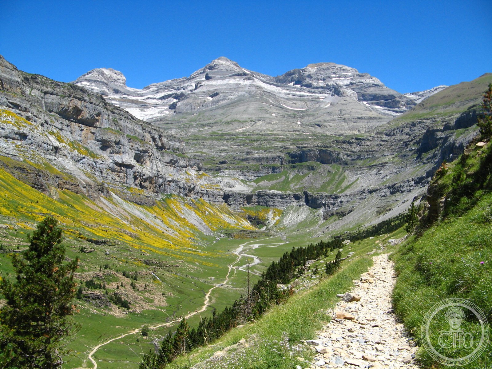
The site is centred on the Monte Perdido massif (3,355 m) and encompasses the three great cirques of the French slope (Gavarnie, Esthére, Troumouse) and the spectacular Ordesa canyon and Añisclo canyon on the Spanish side. The Grande Cascade de Gavarnie, at 422 metres the highest waterfall in France, is the most visited natural feature.
Historical background
The Pyrénées have been inhabited since the Palaeolithic; Bronze Age artefacts and pastoral installations are known throughout the high mountain zone. The distinctive transhumance culture of the central Pyrénées — in which livestock are moved seasonally between the lowland winter pastures and the high mountain summer pastures (estives/puertos) — has operated continuously for at least 2,000 years, shaping the landscape through grazing and the construction of stone shepherds’ huts (cabanes/bordas) and drove roads.
Gavarnie was “discovered” by European Romantics in the early 19th century and became one of the defining landscapes of the Sublime — a place that provoked awe and terror rather than mere aesthetic pleasure. Victor Hugo visited in 1843 and described the cirque as “a colosseum of nature.” The first ascent of Monte Perdido was made by Ramond de Carbounières in 1802. The Spanish side — the Ordesa valley — was declared a national park as early as 1918, one of Spain’s first.
Key features
The Cirque de Gavarnie is the site’s most iconic landscape: a vast semicircular wall of limestone cliffs rising 1,700 metres, with the Grande Cascade de Gavarnie (422 m) thundering down its face. The village of Gavarnie, at the foot of the cirque, is accessible on foot, horseback, or by donkey. The Bretèche de Roland — a dramatic notch in the ridge at 2,807 metres, associated in legend with the Carolingian hero Roland — is visible from the cirque floor.
On the Spanish side, the Cañon de Ordesa is a deep limestone gorge of extraordinary scale (1,000 metres deep, 3–4 km wide) cut by the Río Arazas. The Soaso cirque at the head of the Ordesa valley, with its staircase of waterfalls (Cola de Caballo waterfall) beneath the walls of Monte Perdido, is one of the most dramatic alpine landscapes in Europe. The Añisclo canyon, a narrow slot canyon to the east, is equally impressive.
Cultural and ecological importance
The transhumance pastoral landscape of Pyrénées – Mont Perdu is a living example of a centuries-old land-use system that has shaped the vegetation, land forms, and culture of both the French and Spanish slopes. The seasonal movement of sheep and cattle between valley floor and high mountain pastures has maintained open grasslands that would otherwise revert to forest, supporting a rich flora and fauna including Pyrenean chamois (isard/sarrio), lammergeiers (bearded vultures), and numerous endemic plant species. The site is also geologically outstanding: the limestone massif of Monte Perdido displays classic examples of glacial and periglacial landforms, including U-shaped valleys, cirques, moraines, and small glaciers (the Pyrenean glaciers are rapidly retreating due to climate change).
UNESCO criteria
The site was inscribed as a “mixed” site under criteria (iii), (v), (vii), and (viii). Criteria (vii) and (viii) recognise the site’s exceptional natural beauty (the cirques, canyons, and waterfalls) and its outstanding geological importance (the highest limestone massif in Europe, with classic glacial and karst landforms). Criteria (iii) and (v) acknowledge the site’s cultural importance as an outstanding example of a transhumance pastoral landscape — a living tradition with deep historical roots that illustrates a centuries-old human interaction with a challenging mountain environment.
Visitor experience
The French sector is accessed from Gavarnie village (the most popular approach, with the cirque trail taking 2.5 hours return on foot). The village of Luz-Saint-Sauveur (15 km north) offers accommodation and is the main gateway. The Spanish sector is accessed from the Ordesa National Park visitor centre near Torla; the main valley walk (7 km to the Soaso cirque and Cola de Caballo waterfall) is one of the finest day walks in Europe. In summer, the park runs a shuttle bus from Torla to the valley entrance (private cars restricted). Alpine refuges and mountain huts allow multi-day trekking including the crossing of the international frontier via the Col de Buézy.
Getting there
From the French side: drive from Lourdes south via Luz-Saint-Sauveur to Gavarnie (50 km; 1.5 hours). Nearest rail station: Lourdes (on the Tarbes–Bayonne line). From the Spanish side: Torla is 95 km south of Jaca; fly to Zaragoza (3.5 hours) or drive from Huesca (2 hours). GPS (Gavarnie cirque): 42.650° N, 0.050° E.
Nearby context
Lourdes (50 km north), one of the world’s most important Catholic pilgrimage sites, draws millions of visitors annually and provides a striking cultural contrast to the wild mountain landscape. Jaca (Spain, 90 km east) has an important Romanesque cathedral and is a major stop on the Camino Aragonés (pilgrimage route to Santiago de Compostela). The Pic du Midi de Bigorre (2,877 m, accessible by cable car from La Mongie) offers panoramic views of the entire central Pyrenees. The Cirque de Troumouse (20 km east of Gavarnie) is a quieter but equally impressive glacial cirque within the UNESCO site.
Find it on the map
See this place and what’s around it →📷 Diventa un fotografo di Cultural Heritage Online
Condividi le tue foto dei luoghi: restano pubblicate con la tua firma come autore. Più vengono viste, più ti fai conoscere — e presto un concorso premierà le foto più apprezzate.
Accedi o registrati gratis per aggiungere una foto