Querétaro (XVI sec.): la città coloniale dei conventi e dell’acquedotto
Nel cuore del Messico, Querétaro intreccia il tracciato regolare degli spagnoli con i vicoli tortuosi dei quartieri indigeni. Città di chiese e conventi barocchi, attraversata dalle settantaquattro arcate del suo acquedotto, fu anche la culla della cospirazione che accese l’indipendenza messicana.
At a glance
Querétaro, in central Mexico, is an unusual colonial city in which the regular Spanish grid of the Spanish quarters coexists with the winding lanes of the indigenous neighbourhoods. Founded in the 16th century, it grew rich and pious, filling with Baroque churches and convents, and is crossed by a monumental 18th-century aqueduct of 74 tall arches. It also played a key role in Mexican history as the cradle of the conspiracy that launched the War of Independence. Its historic centre was inscribed by UNESCO in 1996.
Key facts
- UNESCO: World Heritage since 1996 (Historic Monuments Zone of Querétaro)
- Two cities: the Spanish grid beside the winding indigenous (Otomí) quarters
- The aqueduct: an 18th-century aqueduct of 74 arches
- Baroque churches: a wealth of colonial convents and churches
- Independence: cradle of the 1810 conspiracy against Spanish rule
- Empire’s end: where Emperor Maximilian was executed in 1867
History
Querétaro was taken by the Spanish in the 16th century at a frontier between settled and nomadic peoples, and grew as a missionary and trading centre. The Spanish laid out their quarter on a grid, while the Otomí and other indigenous groups kept their own winding streets, producing a town of two interwoven plans. Wealth from mining and farming built dozens of Baroque churches and convents and, in the 1730s–1740s, the great aqueduct that still strides across the city.
In 1810 the city’s notables, meeting in secret, plotted the uprising that became Mexico’s War of Independence. Decades later, in 1867, the Habsburg emperor Maximilian was captured and shot on a hill above the city, ending the brief Second Mexican Empire. The historic centre preserves this layered history.
What you see
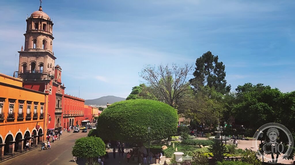
The old centre is a web of plazas and pedestrian lanes lined with colourful arcaded buildings and the towers of churches such as San Francisco and the lavish Santa Rosa de Viterbo. The aqueduct’s row of pink-stone arches, some over 20 m high, marches into the city. Convents, the theatre and the Cerro de las Campanas, where Maximilian fell, complete the historic ensemble.
Shaded squares and gardens, like the central Jardín Zenea, give the city its sociable colonial character.
Practical information
- Old town: walkable, with many pedestrian streets
- Time needed: a day
- Note: a centre of Mexican wine and cheese country nearby
- Setting: in the Bajío highlands of central Mexico
Getting there
Querétaro is the capital of Querétaro state in central Mexico, about 220 km north-west of Mexico City, on the highway and rail routes of the Bajío. It has an airport. GPS: 20.5931° N, 100.3892° W.
Nearby
- San Miguel de Allende — a UNESCO colonial town to the north
- Sierra Gorda — the Franciscan mission churches in the mountains
- Bernal — a town below a great monolithic rock
Sources
- UNESCO World Heritage Centre — “Historic Monuments Zone of Querétaro” (ref. 792)
- Instituto Nacional de Antropología e Historia (INAH) — official body
- Encyclopaedia Britannica — Querétaro
Find it on the map
See this place and what’s around it →📷 Diventa un fotografo di Cultural Heritage Online
Condividi le tue foto dei luoghi: restano pubblicate con la tua firma come autore. Più vengono viste, più ti fai conoscere — e presto un concorso premierà le foto più apprezzate.
Accedi o registrati gratis per aggiungere una foto