Lucca — Le Mura Rinascimentali (4,2 km) e il Centro Medievale Romano-Pisano
The most complete Renaissance circuit of fortifications in the world — 4.2 kilometres of intact sixteenth-century walls around a medieval city whose street grid is still Roman, whose amphitheatre became a piazza still recognisable in its oval form, whose Duomo contains the Volto Santo, and whose tower-houses allowed the private wealth of Lucca’s silk merchants to express itself vertically against the sky.
At a glance
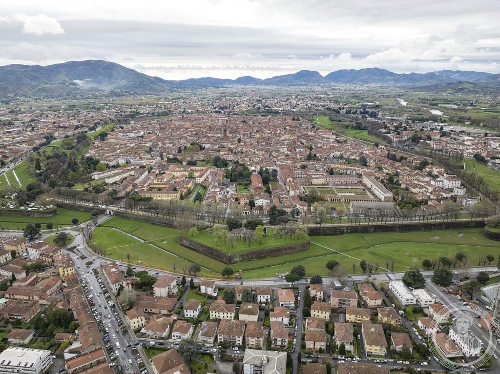
Lucca is a small city (population approximately 90,000) in the Tuscan plain at the foot of the Apennines, 80 kilometres north-west of Florence. It is unique in Italy for two reasons: its Renaissance walls (begun 1504, completed 1645) are the most complete and best-preserved of any Italian city — a 4.2-kilometre circuit still intact at its original height (12 metres), walkable on top (where an avenue of plane trees was planted in the nineteenth century), with 11 pentagonal bastions projecting outward and 3 main gates still in use. Equally unusual is the Roman street plan: Lucca was a Roman colony from 180 BCE, and the orthogonal grid of the Roman castrum is still the street grid of the historic centre — the decumanus maximus is the present Via Fillungo, the forum is the Piazza San Michele.
Key facts
- City walls: 1504–1645; 4.2 km perimeter; height 12 m; width at top 30 m (walkable avenue); 11 pentagonal bastions; 4 gates (Porta San Pietro, Porta Santa Maria, Porta San Donato, Porta Elisa); ~3 million bricks
- Roman plan: colony founded 180 BCE; the Roman grid is the present street plan; the Via Fillungo = decumanus maximus; the Piazza San Michele = Roman forum
- Piazza dell’Anfiteatro: the oval piazza at the centre of the medieval city occupies exactly the footprint of the Roman amphitheatre (II century CE); the medieval buildings were built into and over the amphitheatre cavea; the oval plan is immediately recognisable
- Cattedrale di San Martino: built from XI century; the Volto Santo (a carved wooden crucifix, said to be the original likeness of Christ, carved by Nicodemus; in fact XI century); Tomb of Ilaria del Carretto by Jacopo della Quercia (1406)
- Tower-houses: ~130 medieval towers originally; now approximately 10 survive (among them the Torre delle Ore and the Torre Guinigi with holm oaks on top)
- GPS: 43.8429, 10.5027 — Google Maps
History
Lucca was founded as a Roman colony (Luca) in 180 BCE — one of a series of colonies planted in the Po Valley and the Apennines to consolidate the Roman conquest of northern Italy. The city became an important regional centre and a key node on the Via Cassia; it was where Julius Caesar, Pompey, and Crassus met in 56 BCE to renew the First Triumvirate. In late antiquity Lucca was the capital of the Lombard duchy of Tuscany; in the early medieval period it was the most prosperous city in Tuscany, known particularly for its silk industry — the city’s silk merchants traded with Constantinople and the Arab world from the eighth century.
The decision to build new Renaissance walls in 1504 was driven by the development of artillery warfare: the medieval walls (still largely visible within the later structure) were too thin to resist cannon fire. The new walls were designed in the Italian “trace italienne” system (pentagonal bastions that eliminate dead angles) by a series of engineers; the project took 141 years (1504–1645) and was never used in a siege — Lucca’s independence (as a republic from 1369 to 1799) was maintained by diplomacy rather than force. The walls were never breached and are thus intact to their full original height and plan.
What you see
The walls: the best experience of the walls is walking or cycling along the promenade on top (open continuously; free; bicycle rental at the gates). The full circuit takes approximately 45 minutes on foot or 20 minutes by bicycle. The pentagonal bastions project outward from the wall at each corner; from the top of a bastion, the geometry of the Italian trace italienne system is legible: the angle of the bastion eliminates any position from which an attacker could be in dead ground relative to the defenders. The gates (particularly Porta San Donato on the north-west side) give the clearest sense of the wall thickness: approximately 30 metres.
Inside the walls, the three most important monuments are the Piazza dell’Anfiteatro (the oval piazza that preserves the footprint of the Roman amphitheatre — stand at the centre and observe that the buildings around it all lean slightly inward, following the curve of the ancient cavea), the Duomo di San Martino (with the Volto Santo in its Renaissance tabernacle and the della Quercia tomb), and the Torre Guinigi (with the famous holm oaks growing from its roof, 45 metres above the city).
Gallery
Practical information
- Walls: Always open; free. Bicycle rental on the walls: several operators near the gates; approximately €5/hour, €15/day.
- Cattedrale di San Martino: Free. Open daily 9:30–17:00 (longer hours in summer). Dress code enforced.
- Torre Guinigi: Open daily April–October 9:00–19:30; November–March 9:30–16:30. Admission ~€4.
- Piazza dell’Anfiteatro: Always open; free. The cafes and restaurants around the oval are among the most pleasant in Lucca; the piazza is particularly atmospheric in the evening.
- Music festivals: Lucca Summer Festival (July–August) brings major international performers; Puccini Festival at Torre del Lago (July–August; 20 km west on Lake Massaciuccoli).
Getting there
Lucca, Toscana. By train: direct from Florence (1h30; 8-10 daily); from Pisa (30 minutes; frequent); from Livorno (1h). The station is on the south side of the city, just outside the Porta San Pietro gate (5 minutes on foot to the historic centre). By car: A11 (Florence–Pisa) exit Lucca; A12 (Genova–Livorno) exit Lucca Ovest. Parking: at the walls (Piazzale Ricasoli, Piazzale Risorgimento; free and paid). The historic centre is a ZTL zone (residents only by car); all visiting is on foot or by bicycle. From Florence: 80 km, 1h by car or 1h30 by train. From Pisa: 20 km, 25 minutes by car, 30 minutes by train.
Nearby
- Pisa — 20 km west; Piazza dei Miracoli (UNESCO 1987) with the Cathedral (1063), Baptistery (1152), and Leaning Tower (1173–1372); the tower has a documented lean of 3.97° (reduced from 5.5° by intervention 1990–2001) and is the most recognisable building in Italy after the Colosseum
- Bagni di Lucca — 25 km north-east; spa town in the Apennine foothills; the thermal waters were used by Napoleon, Elisa Baciocchi, Byron, Shelley, Heine, and Montaigne; the Villa Mansi and Villa Torrigiani (16th-century garden) are nearby
- Garfagnana — the Apennine valley north of Lucca; medieval castles (Castelnuovo, Castiglione di Garfagnana), chestnut forests, the marble quarries of Carrara (30 km north-west); the Grotta del Vento (1 km deep) is Italy’s most visited show cave
Sources
- Wikipedia EN: Lucca
- Wikipedia EN: Walls of Lucca
- Hughes, Quentin: “Military Architecture and the Defence of Lucca,” Fort 28 (2000)
- Comune di Lucca: comune.lucca.it
Find it on the map
See this place and what’s around it →📷 Diventa un fotografo di Cultural Heritage Online
Condividi le tue foto dei luoghi: restano pubblicate con la tua firma come autore. Più vengono viste, più ti fai conoscere — e presto un concorso premierà le foto più apprezzate.
Accedi o registrati gratis per aggiungere una foto