Valle dei Templi di Agrigento — Akragas Greca
The largest and best-preserved concentration of ancient Greek temples outside Greece: seven Doric temples on a limestone ridge 3 km south of Agrigento, built between 510 and 430 BCE by the citizens of Akragas, then the second-largest city in the Greek world after Syracuse.
At a glance
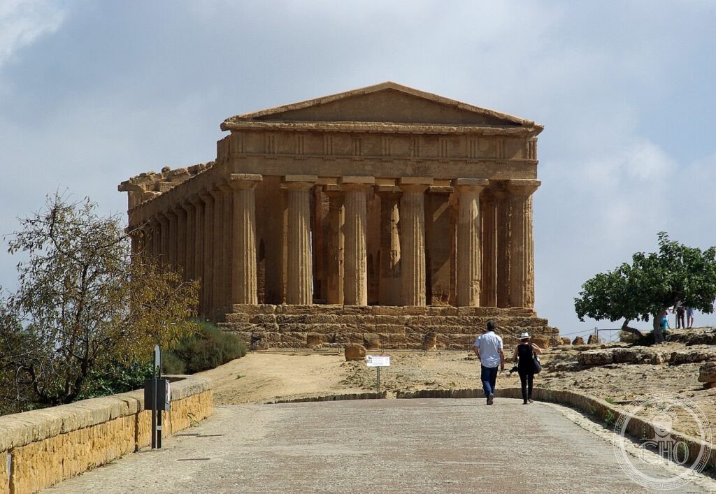
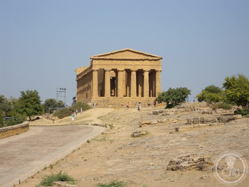
The Valle dei Templi is not a valley but a ridge — a long limestone escarpment running east-west below the ancient city of Akragas (founded 580 BCE), chosen for its visibility from the sea and its defensibility from the land. Seven major Doric temples were built here between 510 and 430 BCE, all facing east toward the rising sun as Greek ritual required. The best-preserved, the Temple of Concordia (c. 430 BCE), owes its exceptional state to conversion into a Christian church in the 6th century CE: the cella walls were pierced with arched openings between the columns, and the temple interior divided into nave and side aisles, preserving the structural system while transforming its use. UNESCO inscribed Agrigento in 1997 under criteria i, ii, iii, and iv.
Key facts
- Tempio della Concordia: c. 430 BCE; 39.44 m × 16.91 m; 34 columns (6 × 13); converted to church 6th century CE; best-preserved Doric temple outside Greece
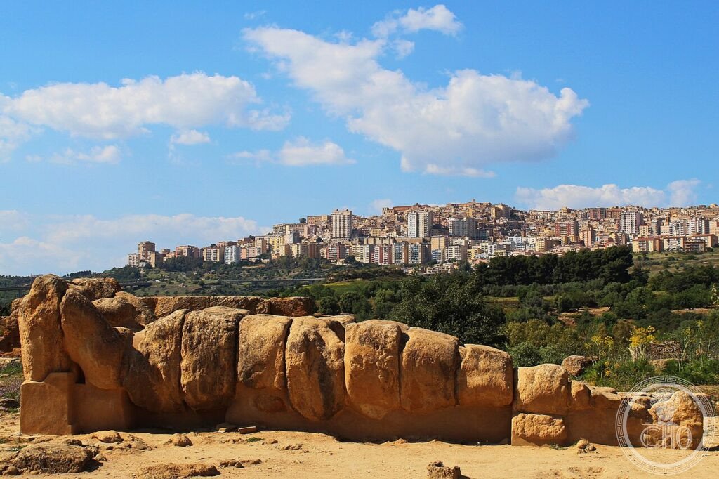
- Tempio di Giunone Lacinia: c. 450 BCE; 38.15 m × 16.9 m; 25 of original 34 columns standing; fire damage from Carthaginian attack 406 BCE visible in reddened stone
- Tempio di Ercole: 510–480 BCE; oldest at the site; 9 of 38 columns re-erected 1924 by Captain Alexander Hardcastle
- Tempio di Zeus Olimpico: begun c. 480 BCE after Battle of Himera; 112.7 m × 56.3 m, the largest Doric temple ever attempted; collapsed, never completed; Telamone (Atlas figure, 7.5 m) copy at Museo Regionale
- Akragas: founded 580 BCE by settlers from Rhodes and Gela; population 200,000 at its peak (5th century BCE); second city of the Greek world after Syracuse
- UNESCO inscription: 1997, criteria i, ii, iii, iv
- Coordinates: 37.2900° N, 13.5885° E — Google Maps
History
Akragas was founded as a Rhodian-Geloan colony in 580 BCE on a site protected on three sides by rivers (the Akragas and the Hypsas) and on the north by the hill of the acropolis. The city's rapid growth was fuelled by the fertile hinterland, sulphur exports, and control of grain trade routes. Under the tyrant Theron (488–472 BCE), Akragas reached its greatest extent; its victory at the Battle of Himera in 480 BCE (against Carthage and Persian-backed forces) coincided with the Battle of Salamis, leading ancient writers to speak of a double triumph of Greek civilisation. The prisoners taken at Himera provided slave labour for the construction of the Olympic Temple of Zeus, begun immediately after the battle.
In 406 BCE, a Carthaginian army sacked Akragas, burning the temples and deporting the population. The Temple of Juno Lacinia shows scorch marks from this fire on its stone columns. The city recovered partially under Timoleon (340 BCE) and then under Roman rule (Sicily was the first Roman province, 227 BCE), but never regained its 5th-century splendour. The limestone columns and entablatures of the temples were gradually removed in the medieval period to build Agrigento's cathedral and churches. The Temple of Concordia alone survived intact because its transformation into the Church of San Gregorio delle Rape preserved its structure while hiding it from later quarrying.
What you see
The Temple of Concordia's 34 columns of golden local limestone (calcarea nummultica) stand to their full height of 6.7 metres, with the original entablature and much of the pediment frieze intact. The columns taper from a base diameter of 1.32 metres to 1.01 metres at the capital, a ratio that creates the optical illusion of taller, more slender shafts than the actual proportions would suggest. Inside the cella, the Christian arched openings (6th century) align with the column intercolumniations, so that looking through the arches from the east end one sees the original Doric columns framed in Byzantine round arches — 900 years of Mediterranean religious history superimposed in a single view.
The Temple of Olympian Zeus, though collapsed, is readable as the most ambitious Doric structure attempted in antiquity. Its peristyle was pseudo-peripteral: the columns were engaged with the outer wall, not free-standing, and between them stood Atlas figures (Telamones) 7.5 metres tall, their arms raised to support the entablature. A copy of one Telamone lies on the temple floor for scale; the original is in the Museo Regionale di Agrigento. The combined visual impact of Telamone, column, and entablature would have given the building a vertical emphasis exceeding all previous Greek temples.
Practical information
- Opening hours: Daily 08:30 to sunset; reduced hours December–January
- Tickets: Book at coopculture.it or at the entrance; combined ticket with Museo Regionale
- Best time: Golden hour (1 hour before sunset) when limestone turns amber; early morning to avoid heat
- Almond Blossom Festival: February; almond trees flower between the temples, timing varies by year
- Time needed: 2–3 hours for the ridge; add 1 hour for Museo Regionale (Telamone + vase collection)
Getting there
Agrigento Centrale railway station is 3 km from the temple ridge; walk (30 min) or take bus line 1 or 2 from Piazzale Rosselli. Palermo by train: 2 hours (Trenitalia direct). By car from Palermo: 130 km via SS189; park at Valley entrance (free) or at the Parcheggio Tempio della Concordia (paid). Palermo Airport (PMO) is 125 km; Catania Fontanarossa (CTA) is 180 km.
Nearby
- Museo Regionale di Agrigento: Telamone from Olympian Zeus temple, Greek vases, and Hellenistic statuary from Akragas
- Selinunte: 80 km west — another Greek colonial city with five large temples, destroyed by Carthage 409 BCE
- Villa Romana del Casale, Piazza Armerina: 80 km northeast — late-Roman villa with the largest in-situ Roman mosaic in the world; UNESCO 1997
Gallery
Sources
- UNESCO World Heritage List — Archaeological Area and the Patrimonial Agrigento, rif. 831, inscribed 1997
- Parco Archeologico della Valle dei Templi — parcovalledeitempli.it
- Robin Lane Fox, The Classical World, Penguin, 2006
- Wikimedia Commons — CC BY-SA images of Agrigento temples
Find it on the map
See this place and what’s around it →📷 Diventa un fotografo di Cultural Heritage Online
Condividi le tue foto dei luoghi: restano pubblicate con la tua firma come autore. Più vengono viste, più ti fai conoscere — e presto un concorso premierà le foto più apprezzate.
Accedi o registrati gratis per aggiungere una foto