
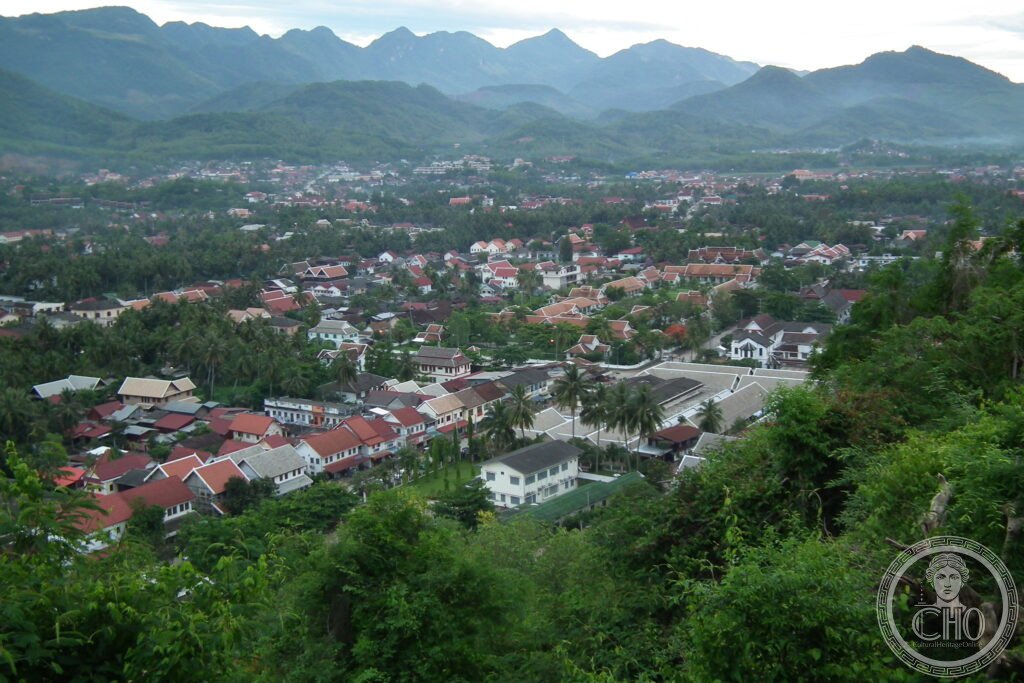
At the meeting of the Mekong and the Nam Khan, Luang Prabang keeps its temples, its French colonial streets and its dawn alms-giving procession largely intact. It is this coexistence of Lao and colonial architecture, still lived in and still used for worship, that earned the old royal capital its UNESCO listing.
At a glance
Luang Prabang sits where the Nam Khan flows into the Mekong, ringed by forested hills. It was the capital of the Lao kingdom of Lan Xang from 1353 until the mid-sixteenth century and later remained the country’s religious centre even after political power moved elsewhere. The historic quarter, protected as a UNESCO World Heritage Site since 1995, holds around thirty Buddhist wats alongside houses and public buildings put up during the French protectorate. Every morning at dawn, monks from the town’s monasteries walk in procession to receive rice from kneeling townspeople, a ritual known as Tak Bat that is said to have continued here for centuries.
Key facts
- Location: confluence of the Mekong and Nam Khan rivers, Luang Prabang Province, Laos.
- Founded as capital: Kingdom of Lan Xang, 1353, under King Fa Ngum.
- UNESCO status: historic town inscribed on the World Heritage List in 1995 for its blend of traditional Lao and French colonial architecture.
- Temples: roughly thirty Buddhist wats, the most notable being Wat Xieng Thong, founded around 1559.
- Sacred object: the Phra Bang Buddha, from which the city takes its name, kept in the Haw Pha Bang chapel.
History
Luang Prabang became the capital of Lan Xang in 1353 under King Fa Ngum, who renamed the city after the Phra Bang Buddha image given to him as a symbol of Buddhist legitimacy. Theravada Buddhism was later established as the state religion, and in the 1560s King Setthathirath moved the political capital south to Vientiane in the face of Burmese pressure, leaving Luang Prabang as the kingdom’s spiritual centre. Lan Xang split into three rival kingdoms in 1707, and Luang Prabang came under Siamese vassalage from 1779. The town was sacked by Black Flag bandits from China in 1887.
In 1893 the Franco-Siamese Treaty brought Laos under French protection as part of French Indochina, and colonial buildings went up alongside existing Lao temples and houses without the older architecture being cleared away. Japanese forces occupied the region between 1941 and 1945, after which Lao independence movements gathered pace; full independence came with the 1954 Geneva Conference. Between 1964 and 1973 the country was drawn into the covert conflict linked to the wider Indochina wars, with heavy American bombing of the Plain of Jars in eastern Laos leaving large quantities of unexploded ordnance still in the ground. The communist Pathet Lao took power in December 1975; the last king, Savang Vatthana, abdicated and was later sent to a re-education camp, where he died in 1984. Luang Prabang’s historic centre was inscribed as a UNESCO World Heritage Site in 1995.
What you see
Wat Xieng Thong remains the town’s finest temple, its low, sweeping multi-tiered roof characteristic of the Luang Prabang style, and its rear wall carrying a Tree of Life mosaic in coloured glass added in 1957. The former Royal Palace, the Haw Kham, was built by the French in 1904 for King Sisavang Vong and now serves as a museum, its throne hall and reception rooms holding royal regalia; the Phra Bang Buddha itself stands in the adjoining Haw Pha Bang chapel, completed in 2006. Wat Mai, dating from 1796, has a five-tiered roof and gilded relief panels on its facade depicting the Buddha’s previous lives, regarded as some of the finest traditional Lao carving in the town.
Mount Phousi rises above the centre and is climbed by a stair of 329 steps to the hilltop stupa of Pha That Luang, built in 1804, with views over the Mekong-Nam Khan confluence. Along the riverfront, French colonial villas line Rue du Rempart, and the daily market brings craft and produce stalls close to the water. Outside the town, Kuang Si Falls lies to the south, its turquoise pools set in forest, while Pak Ou Caves upstream on the Mekong hold thousands of Buddha statues left by pilgrims over the centuries.
Practical information
- Tak Bat etiquette: the alms procession takes place at first light along the main streets; visitors are asked to keep well back, stay silent and avoid flash photography.
- Getting around: the historic centre is compact and best explored on foot or by bicycle, with Mount Phousi, the Royal Palace Museum and the main wats within walking distance of each other.
- Excursions: Kuang Si Falls and Pak Ou Caves are popular half-day trips out of town; check current transport options locally.
- Official information: current opening arrangements, entry conditions and any restrictions should be checked through the relevant local heritage authority before visiting.
Getting there
Luang Prabang is served by its own international airport, connecting the town to Vientiane and to regional hubs; travellers should check current flight schedules directly with airlines or the airport rather than relying on fixed timings. Overland travel from Vientiane is also possible by road.
Nearby
- Kuang Si Falls — around 35 km south of town, a series of turquoise pools set among forest.
- Pak Ou Caves — upstream on the Mekong, caves holding Buddha statues placed by pilgrims over many generations.
Sources
- UNESCO
Find it on the map
See this place and what’s around it →📷 Become a Cultural Heritage Online photographer
Share your photos of places: they stay published under your name as the author. The more they're seen, the more you get noticed — and soon a contest will reward the most appreciated photos.
Log in or sign up free to add a photo