The Piave river runs for 220 kilometres from the Carnic Alps to the Adriatic north of Venice. For roughly eight months — from October 1917 to November 1918 — it was also the line that separated Italy from military collapse. Austria-Hungary held the eastern bank; Italian forces held the western one. The landscape between them, from the forested ridge of Montello in the north to the flat agricultural plain at Fagarè in the south, was transformed into one of the most contested military zones on the entire Western or Italian Front. Today three sites on this former front allow a visitor to understand what was at stake, what happened, and what it cost.
The Disaster That Made the Piave Necessary
To stand at any of these memorials without understanding Caporetto is to miss the frame. On 24 October 1917, Austro-Hungarian and German forces launched an assault near the Slovenian town of Kobarid — Caporetto in Italian, Karfreit in German — that broke the Italian Second Army’s line within hours. Using infiltration tactics and gas artillery, the attack exploited a weakness in the Italian defensive structure that had been visible to commanders for weeks. The breakthrough widened rapidly. Within days, Italian forces were retreating across two successive river lines. By early November 1917, approximately 700,000 Italian casualties had been tallied — some 40,000 killed or wounded, around 280,000 taken prisoner, and the rest dispersed or missing. The Italian front had moved more than 100 kilometres to the west and south. The Piave was the last defensible line before the Venetian plain.
Where to Begin: Kobarid
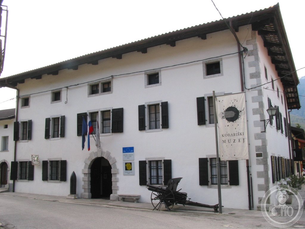
The Kobariški muzej opened in 1990 in the building at Gregorčičeva ulica 10, Kobarid, and won the Council of Europe Museum Prize three years later. The recognition reflected something the museum had understood that many post-war institutions had not: the Isonzo Front was fought over by Italian, Austro-Hungarian, German, and Slovenian-speaking soldiers on what was — and is — Slovenian land. Presenting that history meant holding multiple national perspectives simultaneously rather than resolving them into one official account.
The exhibition covers the full arc of the Isonzo Front from 1915 to 1917, with particular depth on the Twelfth Battle — the Caporetto breakthrough. Maps, dioramas, weapons, personal effects, and documentary film reconstruct the offensive from both sides of the line. The section on the civilian population of the Soča valley is unusual in European war museums: the people who lived here — many of them Slovenian-speaking — experienced the war not as combatants but as subjects to be evacuated, occupied, and displaced by armies speaking other languages. From the museum, a 15-minute uphill walk reaches the Italian Charnel House on Taborska Hill, a large ossuary chapel built between 1938 and 1941 that holds the remains of 7,014 Italian soldiers.
The Hill That Held: Montello
After the retreat stabilised on the Piave, the Montello — a long, forested hill above Nervesa, on the northern bank — became one of the most closely watched points on the entire front. When Austria-Hungary launched the Battaglia del Solstizio on 15 June 1918, the Montello was among its primary objectives. Austro-Hungarian forces crossed the Piave and seized roughly half the hill in the first assault. Italian counterattacks under General Pennella and the 22nd Army Corps held and then pushed back. By 22 June, after a week of fighting, the Austrians had re-crossed the river. Their casualties across the entire front totalled approximately 150,000; the Italian Army had proved that Caporetto had not broken it.
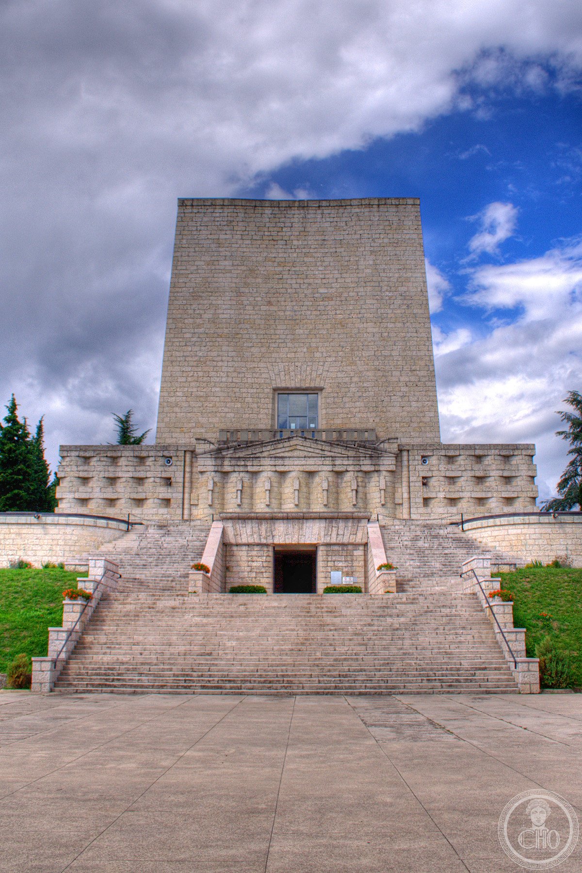
The town of Nervesa added “della Battaglia” to its official name after the war — one of the rarer cases where a battle is permanently embedded in a municipality’s legal identity. The Sacrario Militare del Montello, designed by Roman architect Felice Nori and completed in 1935, stands at 176 metres elevation on the hill’s eastern end. It is a 32-metre square tower, tapering slightly as it rises, built in plain stone with limited ornament. Inside, four floors hold the remains of 9,325 soldiers gathered from 120 military cemeteries along the middle Piave; 6,095 of those have been identified. A museum corridor on the third floor holds weapons, documents, and photographs from the fighting. From near the top of the tower, the panorama extends across the Piave floodplain toward the Venetian plain.
The Crossing Point: Fagarè
Forty kilometres downstream, where the Piave straightens through flat agricultural land, the Sacrario Militare di Fagarè della Battaglia marks a site with a different chronology. Fagarè saw defensive fighting during the June 1918 battle, but its distinctive moment came four months later. The Battle of Vittorio Veneto, launched on 24 October 1918, required Italian forces to cross the Piave. At Fagarè, troops established bridgeheads on the eastern bank and pushed north and east. The Austro-Hungarian line, already weakened by internal political disintegration, broke. An armistice was signed on 3 November 1918. The war on the Italian Front ended at this river.
The sacrario was designed by Pietro Del Fabro and completed in 1935 on the site of a temporary postwar monument. Its form is an elongated exedra — a curved, arched portico in pale marble — flanked by two solid terminal buildings. Nine barrel-vaulted naves hold 5,191 identified soldiers in individual marble-sealed niches, and two lateral naves contain collective urns with 5,350 unidentified. The memorial incorporates fragments of a wall on which soldiers wrote during the June 1918 fighting: “All heroes. Either the Piave or all killed.” Among those buried here is Lieutenant Edward McKey, an American Red Cross officer, whose personal friendship with Ernest Hemingway produced a poem the author composed in his memory, now displayed in the central chapel.
The Route and Its Logic
Travelling from Kobarid to Fagarè via Nervesa della Battaglia is a drive of roughly 150 kilometres and 2.5 hours, tracing the geography of Italy’s last year of war in reverse chronological order — beginning where the crisis originated in 1917 and ending where the final crossing took place in 1918. The landscape changes as you go: the high valley of the Soča gives way to the more open terrain of the Friulian plain, then to the flat Veneto lowlands where the Piave runs between its embankments. Each site asks a different question. Kobarid asks what kind of war this was and what it meant to the people who lived here. Montello asks what happened when the Italian Army was tested again, after its worst defeat. Fagarè asks what the end of the war looked like from the ground up.
None of the three sites draws large tourist crowds. The Italian ossuaries receive school groups in spring and families of veterans’ descendants, but on most days visitors have the structures almost to themselves. Kobarid is better known among military history enthusiasts and is listed in several European cultural tourism guides, but the town is small and the surrounding valley lightly visited outside summer. The understatement of the places is itself instructive: the Piave line held approximately 500,000 soldiers and resulted in losses counted in the hundreds of thousands, yet no single monument on this route carries the visual weight of Redipuglia or the Douaumont ossuary. The scale of the commemoration is deliberately measured, which makes the numbers, when you read them on the plaques, more startling rather than less.