Easter Island (Rapa Nui)
The most remote inhabited island in the world and the site of the most astonishing exercise in monumental stone sculpture undertaken by a pre-modern Polynesian culture — Easter Island, where the Rapa Nui people carved and transported over a thousand stone figures across a volcanic island in the South Pacific, presents archaeology with both its greatest single technical mystery and its most politically charged environmental collapse narrative.
At a glance
Easter Island (Rapa Nui; Isla de Pascua; UNESCO WHS 1995; the most isolated permanently inhabited island in the world: 3,700 km from the Chilean coast; 2,075 km from Pitcairn Island (the nearest inhabited island — itself one of the most isolated inhabited islands in the world: the most isolated nearest-neighbour pair of inhabited islands in the Pacific); the island (triangular; 163.6 km²; 3 extinct volcanic craters (Rano Kau, Rano Raraku, and Terevaka); the island was settled by Polynesian navigators from the Gambier Islands (or Marquesas Islands — the most debated single origin point in Polynesian settlement history) approximately 1000–1200 CE (the most recently revised settlement date: Thor Heyerdahl’s 1950s theory of South American origin has been comprehensively disproved by genetic analysis — the most thoroughly refuted single archaeological origin theory of the 20th century)); the birdman cult (the “Make-Make” cult that replaced the moai-building ancestor cult after c. 1600 CE — the most complete religious transition on any Polynesian island: the Birdman Competition (Tangata manu): a swimming race to the islet of Motu Nui to collect the first sooty tern egg of the season (the most athletically demanding single religious ritual in any Polynesian culture: swimmers crossed shark-infested open water); the winner’s tribe ruled the island for a year)).
Key facts
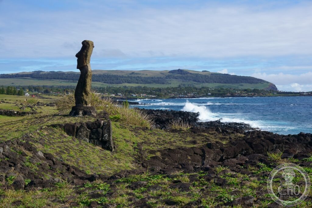
- The moai — the most debated prehistoric stone sculptures: the most precisely counted and least completely explained monumental sculptures in the world — the moai (the monolithic human figure sculptures: 1,040–1,110 known moai (the most contested single count in Pacific Island archaeology); 95% were carved from consolidated tuff at the Rano Raraku volcano (the most efficient single quarrying site for any monumental sculpture tradition: the tuff quarry is so soft that moai could be carved with basalt hand tools in 12–15 months per statue (the most precisely modelled single sculpture production rate in Pacific archaeology (Lipo, Hunt and Haoa 2013)); the ahu (ceremonial platform; 887 known ahu — the most widely distributed pre-modern ceremonial platform network on any Polynesian island; 313 ahu carried at least one moai); the moai face the village (the most counterintuitive single spatial fact in Easter Island archaeology: most moai face inland — away from the sea — watching over the villages they guarded (the most protective single spatial orientation of any monumental sculpture); the exception: the seven moai of Ahu Akivi (the only moai that face the ocean — the only inland moai platform with outward-facing statues; they face the direction from which the Polynesian settlers arrived))
- The moai transport — the greatest engineering mystery in the Pacific: the most debated pre-modern transport problem outside Egypt — the transport (the most physically challenged moai: the average moai weighs 14 tonnes and stood in a quarry 10–15 km from its platform (the most difficult single horizontal transport problem in any Polynesian society with no wheels and no draught animals); the competing theories (the most contested single logistics debate in Pacific archaeology: the horizontal sledge (the most traditional theory: rollers of wood; the most labour-intensive per-unit-of-distance method); the vertical walking method (the most recently experimentally confirmed method: a team of 18 people used ropes to “walk” a 5-tonne moai replica 100 m in 40 minutes in a 2012 experiment (Carl Lipo and Terry Hunt) — the most successfully replicated prehistoric transport experiment in Pacific archaeology; the method is consistent with the oral tradition of the Rapa Nui people that the moai “walked to their platforms”)); the hats (the pukao: cylindrical red scoria top-knots placed on the head of some moai after erection; up to 2.5 m tall; up to 13 tonnes; the most precisely re-enacted single placement challenge in Easter Island experimental archaeology (the pukao were raised by rope ramp — the most recently confirmed single phase of moai construction by physical experiment)))
- The collapse narrative — ecocide or rat infestation? the most politically charged environmental archaeology debate in the Pacific — the collapse debate (Jared Diamond’s “ecocide” theory (Collapse, 2005): the most widely read single environmental-collapse narrative in popular science writing; the theory: the Rapa Nui deforested the island (the island was covered in the Jubaea palm before settlement) in order to build moai (the most extreme single man-made environmental destruction in Polynesian history) — the most repeatedly cited example of human ecological self-destruction in climate literature; the alternative theory (Lipo and Hunt, The Statues That Walked, 2011): the palm forests were destroyed primarily by the Polynesian rat (Rattus exulans) brought inadvertently by the settlers (the most ecologically impactful single species introduction in Polynesian history — the rats ate the palm seeds, preventing forest regeneration; the most completely exonerating alternative for human causation); the current consensus (the most rapidly shifting scientific consensus in recent Pacific archaeology (2010–2026): the collapse was the result of European contact and diseases (1722: Jacob Roggeveen, the first European — the most damaging single European arrival in Polynesian history; the slave raids of the 1860s killed 37% of the population — the most devastating single demographic event in Rapa Nui history), NOT pre-contact deforestation))
- Heritage: UNESCO World Heritage Site, Rapa Nui National Park, inscribed 1995
- GPS: -27.1127° N, -109.3497° E
History
Polynesian settlement (c. 1000–1200 CE; from the Gambier or Marquesas Islands — the most debated single origin point in Eastern Polynesian settlement history; the settlement represents the most eastward single Polynesian colonisation (after New Zealand and the Hawaiian Islands); the moai-building period (the most productive single cultural period in Easter Island’s prehistoric history: moai construction occurred approximately 1000–1600 CE — the most precisely dated single phase of monumental sculpture production in Polynesia; the platforms (ahu) were built first, then the moai quarried and transported — the most precisely sequenced single Polynesian building programme); the toppling period (the Huri Moai: approximately 1600–1800 CE — the intertribal wars that led to the deliberate toppling of all erected moai by rival groups; the most comprehensively self-destructive single cultural act in Polynesian history: every standing moai was toppled by 1722 when the first Europeans arrived); European contact (1722: Jacob Roggeveen (the most consequentially named discoverer of any Polynesian island: Roggeveen arrived on Easter Sunday 1722 (5 April) and named the island accordingly)); the Peruvian slave raids (1862–1863: raids that killed or enslaved 37% of the entire population — the most catastrophic single demographic event in Rapa Nui recorded history; the most directly evidenced cause of the population collapse (the most important alternative to the “ecocide” narrative)); Chilean annexation (1888); current status (Rapa Nui is a Special Territory of Chile with a self-governing council; the land rights dispute (the most active single heritage-sovereignty dispute in the Pacific: the Rapa Nui people claim land rights against the Chilean state); UNESCO WHS 1995.
What you see
The Easter Island visit (the key sites (the most important single itinerary for a 3-day visit; the island is small (163 km²) and all sites are accessible by rented car, quad bike, or horseback): Ahu Tongariki (described in hero caption; the sunrise over the 15 moai is the single most atmospheric moment on the island — the most photographed sunrise in the Pacific; the 3-km walk from the road at 5:30am is the most reliably rewarding predawn walk in South America); Rano Raraku quarry (the quarry and its 397 unfinished moai — the single most archaeologically informative site on the island: the production process is visible in the hillside as a continuous sequence of half-carved statues; the most fully preserved prehistoric quarry in the Pacific; the moai embedded up to their shoulders in the volcanic turf (the most frequently cited visual paradox in Easter Island tourism: the “buried moai” were not buried — they were installed in the ground around the quarry as markers, and the soil accumulated around them); the Rano Kau volcano and the ceremonial village of Orongo (the most dramatic landscape on the island: the 1.6-km-wide caldera lake; the 300-m cliffs above the Pacific; the Orongo village (the 53 stone houses of the Birdman Cult — the most complete pre-modern ceremonial village in the Pacific)).
Practical information
- Getting there: Mataveri International Airport (IPC; the most remote commercial airport on Earth: 3,700 km from the Chilean mainland; 2,075 km from the nearest inhabited island; direct flights from Santiago de Chile (LATAM: 5h 30min; the longest regularly scheduled domestic flight in Chile; approximately 2 flights per day from Santiago) and from Tahiti (Air Tahiti Nui: 5h; the most frequently used Polynesian Triangle air connection; the only regular flight across the South Pacific between South America and French Polynesia)); the entry permit (since 2020, all visitors must obtain an entry permit in advance from the Rapa Nui Municipal Council website — the most recently introduced single visitor permit for any Chilean territory; limited to 3,500 visitors per day in peak season; the most effectively managed single tourism access limit in Chile); the accommodation (the single town: Hanga Roa (population 7,750; the most isolated town of that population size in the world); accommodation options range from backpacker hostels to luxury lodges; the Explora Rapa Nui (the finest single hotel on the island: the most precisely architect-designed single hotel in the Pacific outside Bora Bora))
- Tahiti and French Polynesia: the most mythologised archipelago in the Pacific — Tahiti (5h 30min north-west from Easter Island; the most frequently painted Pacific island: Paul Gauguin (1891–1893 and 1895–1903 — the most consequentially French artist ever to work in the Pacific; the Spirit of the Dead Watching (1892) and Where Do We Come From? What Are We? Where Are We Going? (1897) are the most valuable Pacific-subject paintings in any private collection in the world; the Musée Gauguin in Tahiti (the most important single artist museum in the South Pacific)); the Bora Bora lagoon (the most photographed turquoise lagoon in the world — the most frequently used single image in luxury hotel advertising globally); Rangiroa atoll (the largest atoll in French Polynesia and the second largest in the world; the finest scuba diving in the Pacific))
- Valparaíso and the Chilean coast (UNESCO WHS 2003): the most dramatically sited port city in the Americas — Valparaíso (3,700 km east; the closest major city to Easter Island on the continent; UNESCO WHS 2003 (the Historic Quarter of the Seaport of Valparaíso — the most colourfully painted single hillside heritage quarter in any South American city; the funiculares (cable lifts) connecting the port to the 42 hilltop cerros (hills) — the most extensively preserved Victorian-era funicular network in any port city in South America; the Chilean street art (the most concentrated urban mural programme in Chile: the Cerro Alegre and Cerro Concepción hills are covered in murals by Chilean and international artists — the most internationally photographed outdoor art gallery in South America))
Getting there
Mataveri Airport (IPC) — direct flights from Santiago (5h 30min; ~2/day LATAM) and Tahiti (5h; Air Tahiti Nui). Entry permit required in advance. Accommodation in Hanga Roa. GPS: -27.1127, -109.3497.
Nearby
- Torres del Paine and Patagonia (via Santiago) — the southern tip of Chile (5h 30min flight from Easter Island to Santiago + 3h 30min Santiago to Punta Arenas); the most dramatic mountain landscape in the Southern Hemisphere — described in the Torres del Paine place card at culturalheritageonline.com/places/patagonia-torres-del-paine/; the Easter Island + Patagonia combination is the most geographically extreme single country itinerary possible in South America: from the most remote inhabited island in the world to the most southerly accessible wilderness in the Americas
- Tahiti and Bora Bora (French Polynesia) — 5h 30min north-west (Air Tahiti Nui from Easter Island); described in Practical section; the most scenically lush Polynesian archipelago and the counterpart to Easter Island’s volcanic desolation
- Pitcairn Island — 2,075 km west (the only inhabited island closer to Easter Island than the Chilean coast; permanent population of 47–50 people — the smallest national population in the world for a self-governing territory; the most frequently cited “island of ultimate isolation” in Pacific geography; settled in 1790 by the Bounty mutineers (the most famous mutiny in naval history: Fletcher Christian and 8 other mutineers from HMS Bounty, with 6 Tahitian men and 12 Tahitian women, settled Pitcairn in 1790 — the most consequential single act of Pacific island colonisation in the Age of Sail); the descendants of the Bounty mutineers still live on the island (approximately 35 Seventh-day Adventists — the most religiously homogeneous community of any national population in the Pacific); accessible only by supply ship from New Zealand (the most difficultly accessible inhabited island in the Pacific — no regular flights)
Sources
- Wikipedia, Easter Island; Moai; Rapa Nui National Park; Ahu Tongariki; Huri Moai, accessed June 2026
- UNESCO, Rapa Nui National Park, WHS reference 715, inscribed 1995
- Carl Lipo and Terry Hunt, The Statues That Walked: Unraveling the Mystery of Easter Island, Free Press, 2011
Find it on the map
See this place and what’s around it →📷 Diventa un fotografo di Cultural Heritage Online
Condividi le tue foto dei luoghi: restano pubblicate con la tua firma come autore. Più vengono viste, più ti fai conoscere — e presto un concorso premierà le foto più apprezzate.
Accedi o registrati gratis per aggiungere una foto