Ha Long Bay
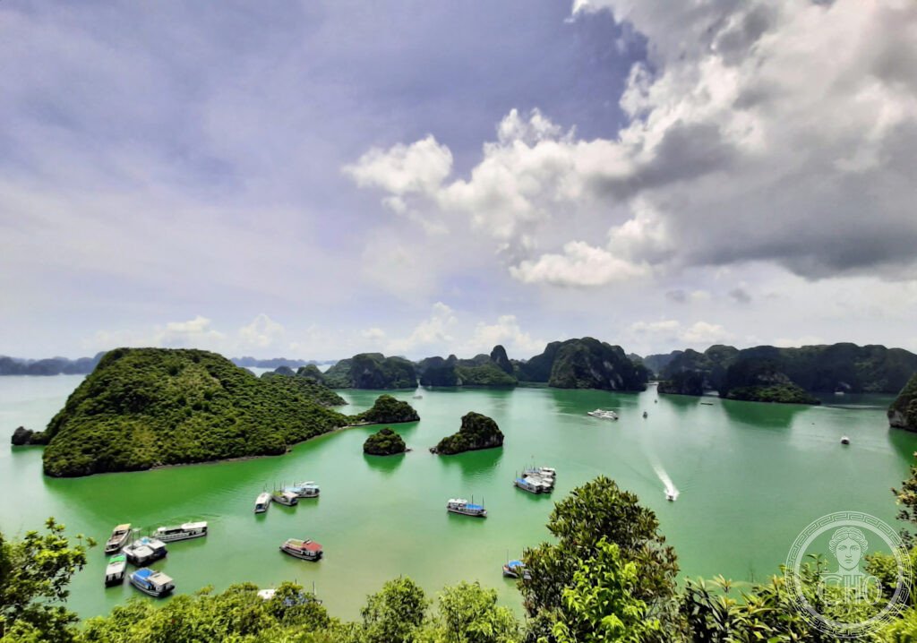
The world’s most iconic karst seascape and one of the few natural landscapes that genuinely matches its photographs — Ha Long Bay, a 1,553 km² bay of approximately 1,969 limestone islands rising from emerald water off the north-east coast of Vietnam, presents a seascape so dramatically otherworldly that it was used as the visual shorthand for “Southeast Asia” in dozens of films and is still astonishing to first-time visitors who have seen hundreds of photographs in advance.
At a glance
Ha Long Bay (UNESCO WHS 1994 (the core zone of 434 km²); extended 2000 (to include the Bái Tử Long Bay adjacent zone and parts of Cat Ba Island; total inscribed zone 1,553 km²); the name “Ha Long” (Hạ Long; “Descending Dragon”) comes from the Vietnamese legend of a mother dragon and her children who descended from the mountains to protect the Vietnamese people from foreign invaders by spitting jewels and jade into the sea; the jewels became the islands; the dragon legend explains the scattered distribution of hundreds of islands in all directions from the shore) is located in Quảng Ninh Province in north-eastern Vietnam, approximately 165 km east of Hanoi (a 3h 30 min drive); the landscape (the Devonian limestone (approximately 500 million years old; the rock was originally deposited as coral reef sediment in a shallow tropical sea; the karst formation — the erosion of the limestone by acidic rainwater percolating through cracks in the rock — began approximately 20 million years ago; the resulting karst towers (fenglin and fengcong karst; the towers are classified as fenglin karst — isolated conical towers rising from a flat base — and fengcong karst — clusters of towers connected at the base) emerged as the defining landscape of Ha Long Bay when rising sea levels after the last Ice Age (approximately 10,000 years ago) flooded the valleys between the karst towers, leaving only the tower summits visible above the water); 1,969 named islands (approximately 989 uninhabited; the human inhabitants of the bay live on the fishing village boats (làng chài) — floating communities of approximately 1,600–2,000 people in several villages scattered through the bay).
Key facts
- The geology of Ha Long Bay: 500 million years in the making — the limestone of Ha Long Bay (the rock is Devonian limestone (approximately 340–500 million years old; Late Devonian to Late Carboniferous; the different geological ages of the rock in different parts of the bay account for the varied appearance of the towers — some are tall and sheer, some are rounded, some are riddled with sea caves)); the karst formation process at Ha Long (the weakly acidic rainwater (rain reacts with atmospheric CO₂ to form carbonic acid; pH approximately 5.6–5.8; dilute but effective over millions of years) percolates through the joints and fractures in the limestone; the acid dissolves the calcium carbonate (CaCO₃ + H₂CO₃ → Ca(HCO₃)₂ (soluble); the soluble calcium bicarbonate is carried away by groundwater; over millions of years, this process created first the cave systems (when the water table was high and dissolved the rock underground) and then the current landscape (when the sea level rose and flooded the valleys); the sea caves in the bay (approximately 50 caves accessible to tourists; the most impressive are Hang Đầu Gỗ (Wooden Stakes Cave; used to store wooden stakes by General Trần Hưng Đạo for the naval battle of Bạch Đằng River in 1288; the interior is enormous — approximately 5,000 m²; stalactites and stalagmites of unusual size), Hang Thiên Cung (Heavenly Palace Cave; the most elaborately decorated cave accessible to tourists; discovered 1993; multiple chambers; extraordinary stalactite formations illuminated by coloured lights))
- The overnight junk cruise: the definitive experience of Ha Long Bay — the junk boat cruise (the vast majority of visitors experience Ha Long Bay on board one of the approximately 500 licensed wooden junk boats (thuyền buồm; some historically accurate sailing junks; most motorised with a junk appearance; sizes from 10-cabin boutique boats to 40-cabin floating hotels); overnight cruises (1 night/2 days; from approximately USD 100–150 per person for budget boats to USD 300–600 for luxury; the price includes accommodation on the boat, all meals, excursions by kayak and rowing sampan into sea caves and lagoons, and a swim stop at a floating beach)); the most important choice for a Ha Long Bay visit is the quality of the boat — the bay is very busy (approximately 3 million visitors per year; the peak season (November–March; dry and cooler) and summer (July–August) are the busiest periods; the cheapest overnight cruises (USD 60–80) are extremely crowded and the boats are parked close together in a central anchorage area that lacks any sense of wilderness; the premium boats (USD 250–600) go to the less-visited eastern parts of the bay (Bái Tử Long Bay; Lan Hạ Bay (adjacent to Cat Ba Island); where the density of other tourist boats is much lower))
- Cat Ba Island: the ecological anchor of Ha Long Bay — Cat Ba Island (the largest island in the Ha Long Bay group; 354 km²; population approximately 13,000; the Cat Ba National Park (covering approximately 1/3 of the island; dense tropical forest; 32 endemic plant species; the Cat Ba langur (Trachypithecus poliocephalus; the golden-headed langur; one of the 25 most endangered primates in the world; population approximately 60–70 individuals surviving in the limestone cliffs of the national park in 2026; critically endangered)); the beach at Cat Ba Town (a crescent-shaped sandy bay; the main beach on the island; gets crowded in peak season); the Lan Hạ Bay (on the south side of Cat Ba Island; the quietest and most pristine part of the greater Ha Long Bay area; a separate municipality from the main Ha Long Bay zone; fewer tourist boats; the preferred cruising area for high-end Ha Long Bay boats))
- Heritage: UNESCO World Heritage Site, Ha Long Bay, inscribed 1994 (extended 2000)
- GPS: 20.9101° N, 107.1839° E
History
Archaeological evidence of human habitation in the Ha Long Bay area dates to approximately 18,000–7,000 years ago (the Soi Nhụ culture (c. 18,000 BCE) and the Cái Bèo culture (c. 7,000–5,000 BCE); these are among the oldest confirmed human habitations in Vietnam); the historic fishermen communities (the làng chài floating villages; inhabited for at least 500 years by fishing families who live their entire lives on the water; the children swim before they can walk; the communities are being relocated to shore housing by the Vietnamese government due to the impact on the bay ecosystem); the Battle of Bạch Đằng River (1288; the Vietnamese general Trần Hưng Đạo defeated the Mongol fleet of Kublai Khan in the bay by driving sharpened stakes into the riverbed at low tide; the Mongol fleet was impaled when the tide rose; the decisive victory that ended the third Mongol invasion of Vietnam); French colonial period (19th century; the French named the region “Baie d’Along” and it became a significant tourist destination); UNESCO WHS 1994; overtourism concerns (2016–present; the Vietnamese government has implemented a series of measures to control visitor numbers and prevent further environmental degradation).
What you see
The approach to Ha Long Bay from Ha Long City (the most significant landmark approaching the bay is the crossing of Bài Thơ Mountain (Núi Bài Thơ; “Poem Mountain”; 200 m; the mountain at the entrance to Ha Long that has a famous poem carved in its cliff face) by the Ha Long Bridge; the classic view of the bay from the shoreline promenade of Ha Long City); the sea caves (the most important are Hang Đầu Gỗ (Wooden Stakes Cave; a 30-min motorboat trip from the main Ha Long Bay pier; UNESCO-designated; the largest cave accessible in the bay); Hang Sửng Sốt (Surprise Cave (also translated as Cave of Surprises or Grotto of Amazement); the most visited cave in the bay; the cave has three chambers; the second chamber (approximately 10,000 m²; the ceiling approximately 30 m high) contains stalagmites claimed to resemble various figures)); the kayak excursion through sea arches and into lagoons (the defining activity of the Ha Long Bay experience; a 2-hour kayak circuit through sea arches, past floating villages, and into enclosed lagoons (hồ nội địa; “inland lakes” — sea water inlets completely enclosed by cliffs with only a narrow sea arch as the entrance) is included on virtually every overnight cruise; the Ba Hầm Lake (Three Tunnels Lake; an enclosed lagoon accessible through three low arches that can only be entered by kayak or rowing sampan; lying in a kayak flat on your back to pass through the low arches and emerging into an enclosed basin surrounded by vertical rock).
Practical information
- Getting there from Hanoi: Ha Long Bay is 165 km from Hanoi (3h 30 min by road via the Hanoi–Hai Phong Expressway; the most common route for tourists; the road journey passes through Red River Delta farmland); options: cruise company minibus (included in the overnight cruise package; the most convenient option; collects passengers from Hanoi hotels and delivers directly to the boat pier at Ha Long Bay; approximately 3h 30 min–4h); private car or taxi (approximately USD 40–80 from Hanoi to Ha Long Bay pier; more flexible than the cruise bus but no advantage in time); seaplane (Hai Au Aviation; 40 min from Noi Bai Airport to Ha Long; approximately USD 60–80 one way; spectacular aerial views of the karst landscape; availability limited); hydrofoil from Hai Phong (1h 30 min; approximately USD 8; the cheapest option but Hai Phong is itself 100 km from Hanoi)
- Weather and timing: Ha Long Bay has two very distinct seasons — dry season (October–April; the best time to visit; the north-east monsoon brings dry, cool weather; the visibility is best; the water is clearest; air temperature 15–25°C; the peak tourist season (December–February) brings the most crowds; shoulder season (October–November, March–April) is the best combination of weather and manageable crowds); wet season (May–September; the south-west monsoon brings high humidity, rain, and occasional typhoons; August–September is typhoon season — cruises may be cancelled or restricted; the temperatures are higher (30–35°C); the water is slightly less clear due to river runoff; the bay is less crowded than in the dry season but the weather uncertainty makes planning difficult); year-round fog (Ha Long Bay is frequently foggy in winter (December–February; the low cloud and fog is atmospheric but reduces visibility for photography; the most iconic grey-foggy Ha Long Bay photographs are taken in these conditions))
- Responsible visiting: Ha Long Bay has serious environmental challenges — the bay is under significant environmental pressure (approximately 3 million visitors per year; the burning of fuel by 500 cruise boats; the runoff from the Ha Long City coal industry (Quảng Ninh Province is one of Vietnam’s main coal-mining regions); the floating fishing village communities (the Vietnamese government has been relocating them to shore, though the ecological and social impact of this policy is debated); the most responsible approach is to choose a boat that goes to the less-visited eastern part of the bay (Bái Tử Long Bay; Lan Hạ Bay near Cat Ba) rather than the central tourist corridor; avoid boats that catch live seafood from the bay for passenger meals; the Steering Committee of Ha Long Bay Management Board (quanlyvinhhalongcom.vn) lists licensed operators)
Getting there
Bus or car from Hanoi (3h 30 min). Seaplane from Noi Bai Airport (40 min). GPS: 20.9101, 107.1839.
Nearby
- Phong Nha-Kẻ Bàng National Park and Hang Sơn Đoòng — 550 km south of Ha Long Bay (8h by road or 1h by domestic flight to Đồng Hới + 1h road); the world’s largest cave and the most extraordinary underground landscape in Asia — Phong Nha-Kẻ Bàng (UNESCO WHS 2003; 885 km² national park in Quảng Bình Province; the most important cave system in Southeast Asia; Hang Sơn Đoòng (discovered by a local farmer in 1991; surveyed by the British Cave Research Association in 2009; confirmed as the world’s largest cave by volume (approximately 38.5 million m³; large enough to contain a Boeing 747 at full wingspan with room to spare; an entire forest (the dolines — skylights where the ceiling has collapsed — allow enough light to support a jungle inside the cave; the jungle has its own weather system, with clouds forming inside the cave when the air temperatures change); 200 m high; 150 m wide; 9 km long; access restricted to 1,000 visitors per year (booked through Oxalis Adventure, the sole licensed operator; 6-day expedition; USD 3,000 per person; booked out years in advance); a shorter cave, the Hang Én (the third largest cave in the world), is accessible on a 2-day camping expedition at approximately USD 300))
- Hanoi Old Quarter — 165 km west of Ha Long Bay (3h 30 min by road); the most complete surviving example of a traditional Vietnamese urban merchant quarter in Southeast Asia — the Hanoi Old Quarter (the 36 Streets; the medieval merchant quarter of Hanoi; each street historically specialised in a single trade (Hàng Bạc = silver goods; Hàng Gai = silk; Hàng Đường = sugar and sweets; Hàng Thiếc = tin goods; the specialisations are still partially maintained today); the ancient guilds are preserved in the street names and in the continuing presence of specialist traders; the Hoan Kiem Lake and the Ngọc Sơn Temple (the Jade Mountain Temple; on an island in the middle of the lake; accessible by the Huc Bridge (The Morning Sunlight Bridge; a red wooden bridge); a small temple with significant philosophical importance — the lake is the setting for the legend of the Restored Sword (the magical sword used by Le Loi to defeat the Chinese Ming dynasty in 1427 and then returned to the lake guardian turtle; the last living Hoan Kiem giant softshell turtle died in 2016 — the Hoan Kiem turtle (Rafetus leloii) was the last remaining individual of the species in Vietnam, and was estimated to be 100+ years old))
- Ninh Binh (Inland Ha Long Bay) — 120 km south of Hanoi (2h 30 min from Ha Long Bay; accessible on the way back from Ha Long to Hanoi); the karst landscape of inland Vietnam — Ninh Binh Province (the “Inland Ha Long Bay” — the same karst limestone tower landscape of Ha Long Bay, but on land rather than at sea; the towers rise from flat paddy fields and rivers instead of from the sea; the visual effect is equally extraordinary but completely different in character; the Tràng An Landscape Complex (UNESCO WHS 2014; the most important karst cultural landscape in Vietnam; the Bích Động Cave (Jade Grotto; a complex of three interlocking cave-temples carved into the cliff face and active as Buddhist temples since the 11th century; the approach by rowing boat through rice paddies); the Hoa Lư (the ancient capital of Vietnam from 968–1010 (before the capital was moved to Hanoi); the Đinh Dynasty and the Early Lê Dynasty; the most important medieval archaeological site in northern Vietnam); the Mùa Cave viewpoint (the famous vista of hundreds of karst towers across a flat valley; the most photographed view in Ninh Binh))
Sources
- Wikipedia, Ha Long Bay; Ha Long Bay geology; Cat Ba Island, accessed June 2026
- UNESCO, Ha Long Bay, WHS reference 672bis, inscribed 1994 (extended 2000)
- Kieran Cunningham, Vietnam, Lonely Planet, 2021 (practical logistics)
Find it on the map
See this place and what’s around it →📷 Diventa un fotografo di Cultural Heritage Online
Condividi le tue foto dei luoghi: restano pubblicate con la tua firma come autore. Più vengono viste, più ti fai conoscere — e presto un concorso premierà le foto più apprezzate.
Accedi o registrati gratis per aggiungere una foto