Old City of Kotor
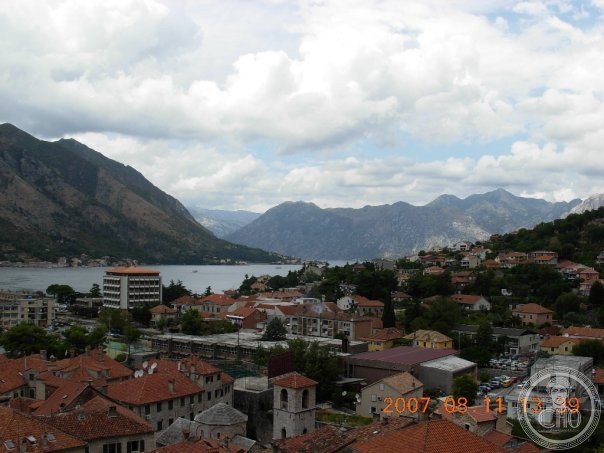
The finest surviving Venetian-era medieval walled city on the Adriatic and one of the most dramatically sited historic cities in Europe — Kotor, crouching between sheer limestone cliffs and the deep, still waters of the Boka Kotorska at the innermost point of the only fjord in the Mediterranean basin, preserves its medieval street plan, its Romanesque cathedral, and 4.5 km of intact Venetian city walls with an atmosphere that feels genuinely untouched by the 20th century.
At a glance
The Natural and Culturo-Historical Region of Kotor (UNESCO WHS 1979; the inscribed zone includes the old city of Kotor together with the Bay of Kotor, the old town of Perast, the island churches of Our Lady of the Rocks and Saint George, and a series of coastal villages; the Bay of Kotor (the Boka Kotorska) is technically a submerged river canyon rather than a true glacial fjord, but the visual effect is indistinguishable — the steep limestone walls of the Dinaric Alps descend directly into dark deep water on all sides, creating an enclosed inland sea of extraordinary dramatic quality); the old city of Kotor itself is a roughly triangular medieval city (approximately 480 m × 380 m; entirely enclosed by the city walls; the street plan established in the medieval period under Serbian, then Venetian rule; three main piazzas (Trg od Oružja (Square of Arms; the main civic square), Trg od Brašna (Flour Square), and Trg od Salata (Vegetable Square)); three principal city gates (the Sea Gate (the main entrance; 1555; directly facing the water); the River Gate (on the east side); the Gurdić Gate (on the south side))); the city is known throughout the Adriatic for its cats — the Kotor cats (the result of the city’s centuries as a port, where cats were kept to control rats on ships and in the city granaries; the city now has multiple cat museums, cat markets, and a cat protection society; the cats are considered guardians of Kotor).
Key facts
- The Bay of Kotor and its geography: the most dramatic enclosed maritime landscape in the Mediterranean — the Bay of Kotor (the Boka Kotorska; from the Latin Sinus Rhizonicus; 87 km of coastline; 28 km long from the Adriatic entrance to the innermost bay (the Bay of Kotor proper, which contains the town of Kotor at its head); maximum depth 60 m; the bay is divided into two outer bays (the Bay of Herceg Novi and the Bay of Tivat) connected by the Kumbor Strait, and two inner bays (the Bay of Risan and the Bay of Kotor proper) connected by the Verige Strait (the narrowest point of the bay; 340 m wide; so narrow that large ships must pass through slowly and carefully; historically the most defensible point in the bay); the surrounding mountains (the Orjen massif; the wettest mountain in Europe with 5,000 mm of precipitation per year; the source of the fresh water that maintains the characteristic dark green colour of the bay even at the surface) rise directly from the water to heights of 1,895 m; the combination of deep water, enclosed topography, dark limestone cliffs, and dense Mediterranean vegetation creates a landscape unlike any other in the Adriatic)
- St. Tryphon Cathedral: the finest Romanesque building on the eastern Adriatic — the Cathedral of St. Tryphon (Katedrala Svetog Tripuna; dedicated to St. Tryphon of Apamea, the patron saint of Kotor (a 3rd-century martyr from Syria whose relics were brought to Kotor by Venetian merchants in 809; the same Venetian relic trade that brought the relics of St. Mark to Venice); the first church on this site was built in 809 when the relics arrived; the current Romanesque cathedral was consecrated in 1166 by Bishop Maure; a catastrophic earthquake on the Feast of St. Tryphon (3 February) 1667 destroyed both the city and the cathedral towers; rebuilt after the earthquake; the current two-bell towers (16th/17th century) replace the original Romanesque towers; the interior (the 14th-century Gothic baldachin over the main altar; the 15th-century painted crucifix (the oldest in Montenegro); the treasury (the reliquary of St. Tryphon; the 14th-century silver gilt reliquary covers for the skull and hand of the saint; among the finest examples of medieval goldsmithing in the Adriatic))
- The city walls and the climb: the most dramatic fortification circuit in the Adriatic — the walls of Kotor (the entire defensive circuit; 4.5 km total length; built by the Byzantine Empire, the Serbian medieval state, the Republic of Venice, and the Habsburg Empire over approximately 1,400 years; the current walls are largely of Venetian construction (15th–17th century); the defining feature of the walls is their verticality — the walls do not stay at the base of the cliff but climb the almost vertical rock face above the city to the Fort of St. Ivan (Fortifikacija sv. Ivana; the highest point of the fortifications; 260 m above the city) via 1,355 steps; the climb takes approximately 30–45 minutes one way; in summer (July–August) this should be done before 9am or after 5pm to avoid heat exhaustion; the view from the fort is one of the finest in the eastern Adriatic — the old city directly below, the innermost bay stretching west, the mountains on all sides)
- Heritage: UNESCO World Heritage Site, Natural and Culturo-Historical Region of Kotor, inscribed 1979
- GPS: 42.4247° N, 18.7714° E
History
Ancient Illyrian settlement (Acruvium); Roman period (Ascrivium; a town of the Decadarch region of Dalmatia); Byzantine rule (535–1185; the city was part of the Byzantine Theme of Dalmatia; the construction of the earliest city walls); Serbian medieval rule (1185–1420; the Nemanjić dynasty; Kotor became the richest city of the Serbian kingdom; the Cathedral of St. Tryphon was built in this period); Venetian Republic (1420–1797; the Serenissima; Kotor was one of the most important Venetian cities on the eastern Adriatic; the current city walls and most of the surviving palaces and churches date from this period; the city’s Latin culture and architecture (the piazzas, the loggia, the campanili, the wellheads) are entirely Venetian in character); the earthquake of 1667 (devastating; the cathedral towers destroyed; many palaces collapsed); Austrian Habsburg rule (1797–1918; the city was called Cattaro under Habsburg rule; the Allied Powers and the Austro-Hungarian naval mutiny in 1918 at Kotor Bay were important late WWI events); Yugoslavia (1918–1991); Montenegrin independence (2006); UNESCO WHS 1979; severe flooding 1979 (the same year as inscription).
What you see
Entering through the Sea Gate (the main gate; the winged Lion of Venice above the arch; the 1944 partisan memorial tablet (Ovdje počiva sloboda — “Here lies freedom”) on the inner arch; the Gate was ceremonially sealed with a stone bearing the Venetian lion on each New Year to ritually re-confirm the city’s loyalty to the Republic); the Square of Arms (Trg od Oružja; the main civic square; the Clock Tower (1602; the circular Pillar of Shame (against which convicted criminals were publicly humiliated) at its base); the Napoleon Citadel (the building on the west side of the square; built 1810 during the brief French Napoleonic period; now the main cultural venue in the city)); the Cathedral of St. Tryphon (the finest building in the city; allow 1h); the Church of St. Luke (the only church in Montenegro with both an Orthodox iconostasis and a Roman Catholic altar — maintained simultaneously by the Catholic and Orthodox communities from 1657 to 1812); the Pima Palace and the Grgurina Palace (the finest Baroque palaces in the city; the Grgurina Palace now houses the Maritime Museum of Montenegro (the most important maritime heritage collection on the eastern Adriatic)).
Practical information
- Getting there: Tivat Airport (TIV; 5 km from Kotor; the most convenient airport; a small airport with seasonal routes mainly to Russian, Ukrainian, Serbian, and UK destinations; taxi EUR 8–10; 10 min); Dubrovnik Airport (DBV; 100 km from Kotor; 1h 30 min by road over the Croatian-Montenegrin border at Debeli Brijeg; taxi approximately EUR 60; or local bus to the Dubrovnik bus station then connection to Herceg Novi then to Kotor); Split (190 km; 3h); most visitors coming from the north use the Dubrovnik–Kotor route, which passes through spectacular Bay of Kotor coastline road (the Jadranska Magistrala coastal road; beautiful but slow — allow 2h 30 min from Dubrovnik to Kotor)
- Crowds and accommodation: Kotor’s old city is small (only about 480 × 380 m) and the main piazza is genuinely overcrowded in summer — July–August 2022 saw approximately 8,000–10,000 day-tripper cruise passengers per day arrive in Kotor (from the cruise ships anchored in the bay; the passengers walk from the cruise dock through the Sea Gate in a single continuous stream for several hours); staying overnight (the old city has approximately 20–30 small family-run apartments and a handful of boutique hotels inside the walls; the most recommended accommodation is in the old city itself — you can walk the streets at 7am before any tourist arrives) transforms the experience from crowd management to genuine immersion; the outer districts of Dobrota and Prčanj (on the north shore of the inner bay; 5 km from Kotor; cheaper) offer quieter alternatives
- The bay circuit: the most rewarding day in Montenegro — the circuit of the Bay of Kotor by car (the full circuit of the bay: Kotor → Perast (17 km; 30 min; the finest Baroque town on the eastern Adriatic; the boat out to the island church of Our Lady of the Rocks (Gospa od Škrpjela; a man-made island built up from rocks and from the anchors of ships whose sailors survived storms by dropping their anchors over the holy spot; the church (1452; expanded 1630) stands on the artificial island; one of the most atmospheric maritime pilgrimage sites in the Adriatic)) → Risan (24 km from Kotor; 40 min; the oldest town in Montenegro; Roman mosaics (the finest Roman floor mosaics in the western Balkans; the Hypnos mosaic (the god of sleep, depicted reclining; found in the remains of a Roman villa; 3rd century AD)) → Herceg Novi (60 km; 1h; the exit point from the bay; the Kula Kanli Tower; the clock tower; the town beach) → Budva (90 km; 1h 30 min; the best old city and beach destination in southern Montenegro))
Getting there
Tivat Airport (5 km; taxi EUR 8). Dubrovnik Airport (100 km; 1h 30 min). GPS: 42.4247, 18.7714.
Nearby
- Perast and Our Lady of the Rocks — 17 km west of Kotor along the inner bay (30 min by road; the most beautiful drive in Montenegro on the D8 coastal road hugging the north shore of the Bay of Kotor); the finest Baroque town in Montenegro and one of the most atmospheric pilgrimage sites in the Adriatic — Perast (a town of approximately 350 people; the most beautifully preserved Baroque coastal town between Dubrovnik and Venice; 17 Baroque palaces surviving in various states of preservation; two churches on small offshore islands (the island of Saint George; a natural island with a Benedictine monastery (12th century); a burial place for captains of the Perast fleet; not accessible to general visitors) and the island of Our Lady of the Rocks (Gospa od Škrpjela; a man-made island created by the gradual piling of rocks and shipwreck materials over the site where a votive icon was found in 1452; the church (1630) on the island contains the most important collection of ex-votos (painted devotional panels donated by sailors) in the Adriatic — approximately 2,500 panels dating from the 15th to the 20th century; a boat from Perast dock takes 5 min; approximately EUR 5 return; the most visited site in the Bay of Kotor after Kotor itself))
- Budva Old Town — 27 km south of Kotor (35 min by road; the D1 road south from Kotor through the Vrmac plateau tunnel, then down to the Budva Riviera); the best beach destination in Montenegro with a medieval old city — Budva (the tourist capital of Montenegro; approximately 20,000 permanent residents but 50,000+ in July–August; the Old Town (Stari Grad; a small Venetian walled town on a promontory; the Cathedral of St. John the Baptist (9th century; rebuilt after the 1979 earthquake); the Citadel (the fortress on the promontory tip; a summer theatre in the open-air upper level; the most panoramic point in Budva); the best beaches (Jaz Beach (5 km north of Budva; the largest beach in Montenegro; 1,400 m long; the site of the annual Summer Festival concerts; Jaz Beach concert (the Rolling Stones played here in 2007 to an audience of 80,000)); Mogren Beach (a 15-min walk from the old town; two coves connected by a tunnel through the rock; the most beautiful beach near Budva))
- Lovćen National Park and the Njeguši Royal Mausoleum — 25 km from Kotor (40 min by road up the famous Kotor–Lovćen serpentine road, one of the most spectacular mountain roads in Europe; 25 hairpin turns climbing from sea level to 1,000 m in 8 km); the sacred mountain of Montenegro and the national mausoleum of Petar II Petrović-Njegoš — Lovćen National Park (the black mountain (the “black mountain” of the English name “Montenegro”; the Lovćen massif; its dark limestone appearance in all weather gives the landscape its monochrome quality); Petar II Petrović-Njegoš Mausoleum (the mausoleum of the poet-prince-bishop (vladika) who wrote The Mountain Wreath (Gorski vijenac; 1847; the founding text of Montenegrin national literature; the greatest poem in the South Slavic tradition); the mausoleum was built inside the mountain by Ivan Meštrović (1974; a monumental Baroque building carved into the living rock at 1,657 m altitude; 461 steps from the nearest car park; the interior contains a massive Meštrović sculptural group; the views from the chapel terrace on a clear day extend from Albania in the south to the islands of Croatia in the north))
Sources
- Wikipedia, Kotor; Bay of Kotor; St. Tryphon’s Cathedral, Kotor, accessed June 2026
- UNESCO, Natural and Culturo-Historical Region of Kotor, WHS reference 125, inscribed 1979
- John Julius Norwich, A History of Venice, Penguin, 1977 (for the Venetian period)
Find it on the map
See this place and what’s around it →📷 Diventa un fotografo di Cultural Heritage Online
Condividi le tue foto dei luoghi: restano pubblicate con la tua firma come autore. Più vengono viste, più ti fai conoscere — e presto un concorso premierà le foto più apprezzate.
Accedi o registrati gratis per aggiungere una foto