Mill Network at Kinderdijk-Elshout
The defining image of the Dutch landscape and the most complete surviving testament to 700 years of Dutch mastery of water management — the 19 windmills of Kinderdijk, built between 1722 and 1761 in the Alblasserwaard polder south-east of Rotterdam, are the most visited site in the Netherlands outside Amsterdam, representing a thousand-year tradition of living below sea level by means of windmill-powered hydraulic engineering: the mills pump water from the drained agricultural polder up to the higher boezem canal, which drains to the river, which discharges to the sea.
At a glance
Kinderdijk is 15 km east of Rotterdam and 20 km south-west of Dordrecht, in the municipality of Alblasserdam (Zuid-Holland province). The site is most easily reached by waterbus from Rotterdam (45 min, seasonal) or by bicycle from Kinderdijk village (10 min along the canal). The 19 windmills stand along two parallel canals in a flat polder landscape; eight of them are still inhabited by families (the millers and their descendants) who maintain the mills and operate them for the public; two windmills are open for interior visits. The windmills operate simultaneously on Saturday afternoons in July and August (the “Molen in Werking” programme) — seeing 19 windmills turning simultaneously is one of the most spectacular experiences the Netherlands offers. The site is photogenic at any time, including winter and at night (illuminated on selected evenings).
Key facts
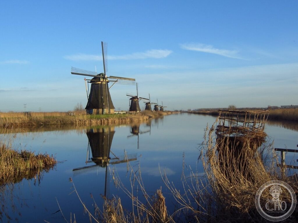
- Why 19 windmills here? The polder drainage problem (1000 AD to the present): the Alblasserwaard is a peat-and-clay polder (drained farmland) approximately 25 km south-east of Rotterdam that has been continuously below sea level since at least the 10th century AD, when the first systematic drainage of the peat bogs began (the decomposition of peat, once drained, causes the land to sink, creating a positive feedback loop — the more you drain, the lower the land sinks, requiring ever-more-powerful pumping; the Alblasserwaard is today approximately 2–6 metres below sea level); the windmills were built in 1722–1761 specifically to solve the drainage crisis of the Alblasserwaard polders: two serious floods in 1726 and 1740 had demonstrated that existing drainage capacity was insufficient, and the water board (the Hoogheemraadschap Alblasserwaard) commissioned 19 new windmills to supplement the older drainage system; the windmills pump water through a system of two stages: the 8 “round stone mills” (the octagonal stone-and-brick mills on the north bank of the main canal) pump water from the deeper inner polders to the intermediate water level; the 8 “hollow post mills” (the timber-framed mills on the south canal bank) pump from the intermediate level to the boezem (the large open-water reservoir at the higher level); the boezem discharges via sluice gates into the river Lek, and thence to the North Sea; the system has been continuously maintained and updated since 1761 (electric pumps now supplement the windmills for routine drainage; the windmills are kept operational and are used as the primary drainage system in emergency situations, such as electrical failures)
- The windmill types at Kinderdijk: the 19 windmills at Kinderdijk are of two main types — 8 “round stone mills” (ronde stenen molens, with a cylindrical stone tower and a rotating cap carrying the sails) and 8 “hollow post mills” (grondzeilers, a type of smock mill with a wooden frame on a masonry base; the entire upper body rotates to face the wind); plus 3 “smock mills” of intermediate type; the stone mills are the most visually prominent (approximately 28 metres tall, with four sails each approximately 28 metres long) and line the north bank of the Kinderdijk canal in a straight row; the hollow post mills are lower and are arranged along the south bank; each mill drives a scoop wheel (a large rotating wheel fitted with wooden paddles that scoops water from the lower channel and deposits it in the higher one) via a wooden gear train inside the mill tower
- The inhabited mills: eight of the 19 windmills are still lived in by families who are employed as millers by the Kinderdijk water board — the millers live in the base of the mill tower (the living quarters are on the ground floor; the gear machinery is on the upper floors) and are responsible for maintaining the mill, operating it when needed for drainage or demonstration, and participating in the weekly/seasonal operating programmes; the living conditions in the mills are comfortable by modern standards (the mills have been upgraded with running water, electricity, and central heating) but the space is tight (the circular tower is approximately 6 metres in diameter); the miller families represent a continuous tradition of Dutch windmill operation that has continued without interruption since 1761
- The name “Kinderdijk” (Children’s Dike): the name comes from the legend of the St Elizabeth’s flood of 1421 (one of the worst flood disasters in Dutch history, in which approximately 10,000 people were drowned and the Grote Waard polder south of Dordrecht was permanently inundated) — according to the legend, after the waters receded, a cradle was found floating on the floodwaters with a living infant inside, kept afloat and balanced by a cat that jumped from side to side as the cradle tilted; the infant was found unharmed; the dike where the cradle came ashore was subsequently called the “Kinderdijk” (Children’s Dike) in memory of this miraculous survival; the legend has been told continuously since the 15th century and is documented in early Dutch chronicles
- Heritage: UNESCO World Heritage Site, Mill Network at Kinderdijk-Elshout, inscribed 1997
- GPS: 51.8839° N, 4.6384° E
History
The Alblasserwaard polder has been continuously farmed and drained since the early medieval period (the first systematic drainage by ditching the peat bogs began approximately 1000 AD, when the region was colonised by Flemish and South Holland settlers under the authority of the Counts of Holland); by the 13th century, the peat had compressed enough through drainage to bring large areas below sea level; the first windmill drainage systems were introduced in the Alblasserwaard approximately 1400 AD; the current 19 windmills were built in 1722–1761 following a series of catastrophic floods (1726, 1740) that demonstrated the inadequacy of the existing drainage capacity; the mills operated as the primary drainage system until the introduction of steam-powered pumping stations in the 1860s (a steam pumping station was built at Kinderdijk in 1868 to handle peak loads); the windmills were retained as back-up drainage; the introduction of diesel and then electric pumps in the 20th century further reduced the operational necessity of the windmills, but they were maintained for their engineering heritage value; Kinderdijk became a tourist destination in the early 20th century (the first tourist photographs of the Kinderdijk mills were taken in the 1890s by the Dutch pictorialist photography movement); the UNESCO inscription in 1997 recognised the complete ensemble of windmills and the water management landscape as a global monument to Dutch hydraulic engineering.
What you see
The visitor experience at Kinderdijk is almost entirely outdoors (the flat polder landscape and the long canal provide the quintessential Dutch landscape experience): the main route is the Kinderdijk canal walk (2.5 km from the visitor centre to the far end of the mill row and back, 1.5–2 hours); along the canal, 19 windmills stand in two parallel rows on either side; two windmills are open for interior visits (the Blokweer mill on the north bank is the visitor mill, open April–October; the interior shows the miller’s living quarters on the ground floor and the gearing machinery on the upper floors); the Nederwaard pumping station museum (at the south end of the site) displays the 19th-century steam and later diesel pumps that supplemented the windmills. The best photography of the mill row requires a wide-angle lens (or a drone); the most striking views are from the canal bank at ground level looking along the row, or from the canal by boat. Boat trips along the Kinderdijk canals are available from April to October (30 min circuit, approximately €12).
Practical information
- Admission: approximately €18 adult (includes visitor centre and access to the Blokweer mill interior; access to the outdoor canal walk is free); the All-In ticket (approximately €22) includes a boat trip; open year-round (the canals and mill row are always accessible on foot; the visitor centre and interior mill are open April–October); the most popular visit time is July–August Saturdays (all mills operating simultaneously, 2:30–5:30pm; booking in advance strongly recommended in peak season); the site is very busy in summer; early morning (9–10am) or autumn visits are quieter
- Getting there: from Rotterdam by waterbus (Waterbus Line 20 from Rotterdam Erasmus Bridge to Kinderdijk; 45 min; seasonal, April–October; approximately €5 one way; the waterbus journey along the Lek and Noord rivers is itself scenic); from Dordrecht by waterbus (30 min); from Rotterdam Central Station by bus 154 (50 min, year-round, the only public transport option in winter); by car from Rotterdam (20 min) or Amsterdam (1h 20 min) via A15/A16; limited car parking at the site (approximately €8/day); bicycle from Rotterdam via the Fietssnelweg (cycle highway) F15 (25 km from Rotterdam centre, 1h by bike on the excellent dedicated cycling infrastructure)
- Rotterdam combination: Kinderdijk is the most visited day trip from Rotterdam; the city offers an extraordinary concentration of post-1940 modern architecture (Rotterdam was almost entirely destroyed by German bombing in May 1940 and rebuilt from scratch using avant-garde designs: the Cube Houses / Kubuswoningen by Piet Blom 1984, the Markthal / Market Hall by MVRDV 2014 — a horseshoe-shaped building with the world’s largest art installation as its interior ceiling, the Erasmus Bridge by Ben van Berkel 1996, and the De Rotterdam building by Rem Koolhaas/OMA 2013 — the largest building in the Netherlands) making Kinderdijk + Rotterdam one of the great heritage-plus-modernism contrasts in Europe
Getting there
Rotterdam by waterbus (45 min, seasonal April–Oct) or bus 154 (50 min, year-round). By car from Rotterdam (20 min). Cycling from Rotterdam on F15 highway (1h). GPS: 51.8839, 4.6384.
Nearby
- Dordrecht — 20 km south-east of Kinderdijk (30 min by waterbus); the oldest city in Holland (first city charter 1220, the first city in what is now the Netherlands to receive civic rights) and one of the most complete 17th-century Dutch townscapes outside Amsterdam — the Dordrecht waterfront (the Wolwevershaven and Nieuwe Haven harbours) preserves a remarkable row of 17th-century brick warehouses and merchants’ houses, still in their original form; the Grote Kerk (Great Church of Dordrecht, 1339–1470 AD; the largest late-Gothic church in the western Netherlands, with the most complete 15th-century stone sculpture programme in the country) and the Dordrechts Museum (the finest collection of 17th-century Dutch golden age paintings outside the Rijksmuseum in Amsterdam, including Albert Cuyp’s river landscapes that epitomise the Dutch love of watery horizontal light)
- Biesbosch National Park — 15 km south of Kinderdijk (20 min by car); the largest freshwater tidal area in western Europe and one of the last remaining floodplain wildernesses in the Netherlands — the Biesbosch (literally “reed forest”) was created by the St Elizabeth’s flood of 1421 (which permanently inundated the Grote Waard polder and converted it into a freshwater estuary); the tidal reed beds and willow forests of the Biesbosch are home to beavers (reintroduced 1988; now approximately 400 individuals, the largest beaver population in the Netherlands), otters, white-tailed eagles, kingfishers, and cormorants; canoe and kayak routes through the Biesbosch channels (the most atmospheric way to experience the landscape, with reed walls rising 3 metres above the water on both sides) are available for hire from the Biesbosch visitor centre at Drimmelen
- Rotterdam Architecture — 15 km west of Kinderdijk (20 min by car or 45 min by waterbus); the most important concentration of contemporary and post-war architecture in Northern Europe — the German bombing raid of 14 May 1940 destroyed approximately 90% of Rotterdam’s historic city centre in 90 minutes, creating a blank slate that Dutch architects used to experiment with modernist and later post-modernist urban form; the key buildings are the Cube Houses (Kubuswoningen, Piet Blom, 1984; 38 cube-shaped houses tilted 45° and raised on hexagonal concrete stilts, with the Blaaktoren “Pencil Building” at the centre), the Markthal (MVRDV, 2014; a 96-metre-high horseshoe arch of 228 apartments with the world’s largest art installation — a digital fruit-and-flower mosaic — on the interior ceiling, sheltering an indoor food market), and the Erasmus Bridge (Ben van Berkel/UN Studio, 1996; an asymmetric cable-stayed bridge nicknamed “The Swan” for the curve of its single pylon, the city’s emblematic image)
Sources
- Wikipedia, Kinderdijk; Mill Network at Kinderdijk-Elshout; Alblasserwaard, accessed June 2026
- UNESCO, Mill Network at Kinderdijk-Elshout, WHS reference 818, inscribed 1997
- Petra van Dam, “Sinking Peat Bogs: Environmental Change in Holland, 1350–1550”, Environmental History 6(1), 2001
- Kinderdijk.nl, official visitor site, 2026
Find it on the map
See this place and what’s around it →📷 Diventa un fotografo di Cultural Heritage Online
Condividi le tue foto dei luoghi: restano pubblicate con la tua firma come autore. Più vengono viste, più ti fai conoscere — e presto un concorso premierà le foto più apprezzate.
Accedi o registrati gratis per aggiungere una foto