
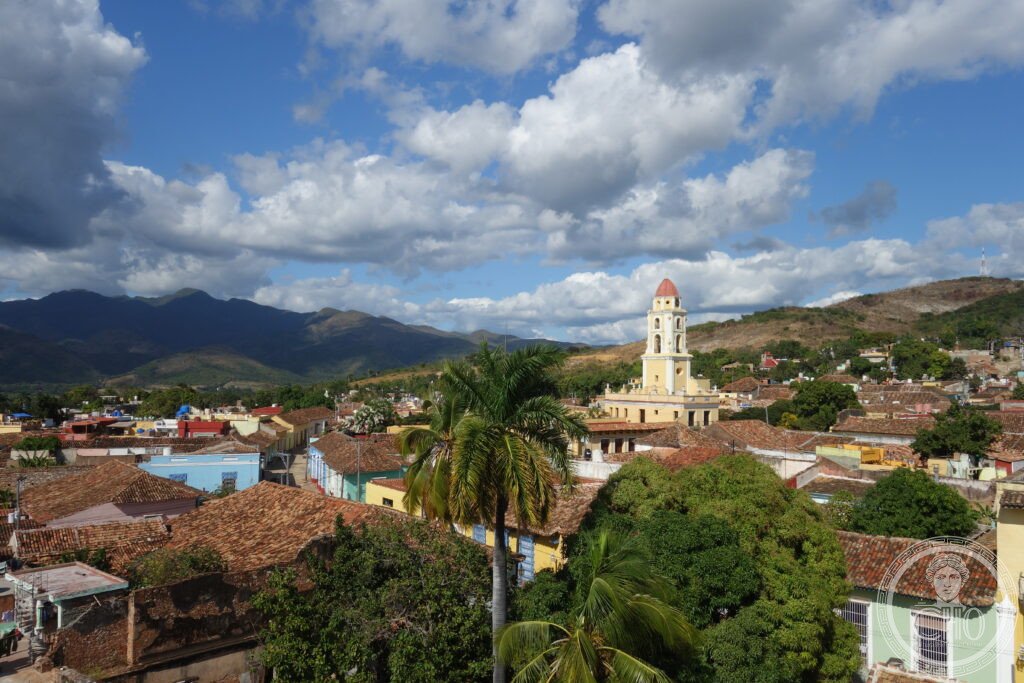
The best-preserved Spanish colonial city in the Caribbean — a grid of cobblestone streets, terracotta-roofed baroque mansions, and painted facades that has changed so little since the 18th-century sugar boom that it is studied as a document of the slave-based plantation economy whose profits built it; the surrounding Valle de los Ingenios (Valley of the Sugar Mills) still contains 75 ruined 18th–19th-century sugar mills and the watchtowers from which overseers monitored the enslaved labour force.
At a glance
Trinidad (official name Villa de la Santísima Trinidad) is a city of approximately 75,000 inhabitants in the Sancti Spíritus Province of central Cuba, on the southern slopes of the Escambray Mountains, 18 km from the Caribbean coast. The city was founded in 1514 by Diego Velázquez de Cuéllar as the third of the seven original Spanish settlements in Cuba (the villas); its extraordinary wealth in the 18th and early 19th centuries derived from sugar production in the Valle de los Ingenios (the plain south of the city), where 75 sugar mills operated by enslaved labour produced approximately one-third of Cuba’s sugar exports. The collapse of the slave trade (1862), the Ten Years’ War (1868–1878), and the subsequent shift of Cuba’s sugar economy to the west of the island left Trinidad economically stagnant — and thus architecturally intact. UNESCO inscribed Trinidad and the Valle de los Ingenios in 1988.
Key facts
- The architecture: Trinidad’s historic centre (the oldest part of the city, covering approximately 40 city blocks around the Plaza Mayor) preserves a virtually complete ensemble of 18th–19th century Spanish colonial architecture; the typical house type — a single-storey or two-storey mansion with thick masonry walls, iron window grilles, interior courtyard, and terracotta roof tiles — was built by the sugar plantation owners (the hacendados) who resided in the city while their enslaved workers operated the mills in the Valle below; the colour palette (ochre, pale yellow, terracotta, turquoise, and white) was maintained by a tradition of lime-wash painting that continues; the grid of cobblestone streets (paved with irregular river stones of varying sizes, worn smooth by centuries of use) is the most consistent distinguishing feature of the city from street level
- Plaza Mayor: the main square of Trinidad, one block from the Convento de San Francisco de Asís; surrounded by four of the most important mansions of the colonial elite (Palacio Cantero — now the Museo Histórico Municipal, with the best collection of colonial furniture and decorative arts in Trinidad; Palacio Brunet — now the Museo Romántico, with 19th-century furnishings; Casa Padrón and Casa Ortiz); the square is paved with white marble tiles and has ornamental iron fences, marble benches, and potted plants; a music bandstand (used for nightly live salsa and son sessions) stands at the centre
- Valle de los Ingenios: the plain south of Trinidad was the sugar-producing zone that made the city rich; at its peak (1820–1850), the Valle had 75 operating ingenios (sugar mills), each worked by a labour force of 50–300 enslaved Africans; the Valle is now agricultural land with scattered ruins of the mills, slaves’ barracks, manor houses, and watchtowers; the Manaca Iznaga Tower (43 metres, built 1816 by the Iznaga family to allow the plantation manager to see across the entire valley and count the enslaved workers) is the most visited monument in the Valle; trains from Trinidad’s station run through the Valle to the Manaca Iznaga estate (daily tourist service)
- The enslaved population: the economic miracle of 18th-century Trinidad was built entirely on enslaved African labour; the Valle de los Ingenios received enslaved people from the Congo, Angola, and Yorubaland (Nigeria) primarily between 1750 and 1850; the descendants of those communities have maintained elements of Yoruba religious practice (Santería/Lucumí) in Trinidad to the present; the Trinidad Historical Museum in the Palacio Cantero documents this history through artefacts (manacles, branding irons, documents) and the personal histories of enslaved people recorded in plantation records
- Music: Trinidad is one of the primary centres of Cuban son (the music that is the ancestor of salsa); the nightly music sessions in the Plaza Mayor (Casa de la Música) and the nearby courtyard of the Casa de la Trova are among the most authentic live Cuban music experiences accessible to visitors; the Trinidad musicians play in ensembles similar in instrumentation to those of the 19th century (tres guitar, double bass, bongó, clave, güiro)
- Heritage: UNESCO World Heritage Site, Trinidad and the Valley of the Sugar Mills, inscribed 1988
- GPS: 21.8027° N, 79.9799° W
History
Trinidad was founded in 1514 by Diego Velázquez de Cuéllar (governor of Cuba, who also founded the other six villas: Baracoa, Bayamo, Camagüey, Holguín, Sancti Spíritus, and Santiago de Cuba); the town was the staging point for Hernán Cortés’s expedition to Mexico in 1519. The city remained a small town through the 16th and 17th centuries, sustained by tobacco cultivation and a modest cattle trade. The transformation came with the sugar revolution of the 18th century: the introduction of steam-powered sugar mills (trapiche), the expansion of the enslaved labour trade by the Asiento de Negros (the licensed slave trade monopoly), and the boom in Caribbean sugar prices after the Haitian Revolution (1791) destroyed French Caribbean production made Trinidad’s Valle de los Ingenios one of the most profitable agricultural zones in the Americas for approximately 50 years (1790–1840).
The decline began with the gradual Spanish suppression of the enslaved labour trade (formally ended 1866) and continued with the Ten Years’ War (1868–1878, the first Cuban independence war), which devastated agricultural production in central Cuba. The subsequent dominance of the western provinces in sugar production, and the completion of the national railway network (which bypassed Trinidad), left the city economically isolated by the 1890s; no significant new construction occurred after approximately 1860, which is precisely why the pre-1860 fabric is so intact today. Cuba’s 1959 revolution nationalised the buildings and maintained them in public use (as museums, schools, and residences); UNESCO inscription in 1988 accelerated conservation efforts.
What you see
The city is best understood by walking: enter the historic centre through the cobblestone streets from the south (from the Casa de la Trova direction), work uphill to the Plaza Mayor (the heart of the city, the cluster of four mansions, the terracotta-tiled church of La Santísima Trinidad, and the Convento de San Francisco), and then climb the bell tower of the Convento (now the Museo de la Lucha contra Bandidos, the museum of the anti-Batista guerrilla campaign) for the definitive view of the city’s terracotta roofscape and the Valle de los Ingenios beyond. The Plaza Mayor at dusk, when the street musicians set up and the light turns the painted facades gold, is one of the most beautiful urban moments in the Caribbean.
The train to Manaca Iznaga in the Valle de los Ingenios (departs Trinidad station daily, 9:30 am, returns afternoon) takes 1 hour to the Iznaga estate; the 43-metre watchtower (climb available) and the ruined mill machinery give the clearest physical sense of the sugar economy; the views from the top of the tower (across flat cane fields with other mill ruins visible) explain why it was built where it was. Returning on horseback (2 hours, arranged through local guides) is an alternative to the train.
Practical information
- Admission: the historic streets are free; the museums (Museo Histórico Municipal in the Palacio Cantero, Museo Romántico in the Palacio Brunet, and the Convento bell tower) charge 2–5 CUP (Cuban pesos) each; photography is permitted everywhere; the city is compact and best explored on foot (2–3 hours for the historic centre, full day including the Valle de los Ingenios)
- Getting there: Havana José Martí International Airport (HAV) or Varadero Juan Gualberto Gómez Airport (VRA) are the primary entry points; Trinidad is approximately 330 km from Havana (5–6 hours by tourist bus, Viazul; or hire car); the Viazul bus service from Havana passes through Cienfuegos (3 hours) to Trinidad; from Cienfuegos, Trinidad is 80 km (1.5 hours); the scenic route from Cienfuegos to Trinidad passes through the Escambray Mountains and the Bay of Cienfuegos; the best regional circuit is Havana–Cienfuegos–Trinidad–Santa Clara–Havana (3–4 days)
- Accommodation: Trinidad has an excellent and extensive network of casas particulares (private homestays, the Cuban equivalent of B&B, renting rooms in colonial family houses in the historic centre); staying in a casa particular in the historic centre is the recommended approach — the morning view of the cobblestone street from the balcony of a colonial house is an integral part of the Trinidad experience; book in advance (particularly in high season, December–March and July–August)
Getting there
From Havana by Viazul bus (5–6h) via Cienfuegos. From Cienfuegos 80 km / 1.5h. Albert Schweitzer Airport (TND) in Trinidad for charter flights. GPS: 21.8027, -79.9799.
Nearby
- Cienfuegos Urban Historic Centre — 80 km west of Trinidad; a 19th-century planned city on the Bay of Cienfuegos, built primarily by French immigrant colonists and therefore the most architecturally European city in Cuba (the grid of neoclassical buildings around the Parque José Martí is the primary monument; the Teatro Tomás Terry, 1890, is the finest 19th-century theatre interior in Cuba); UNESCO WHS 2005
- El Nicho waterfalls, Escambray Mountains — 50 km north of Trinidad in the Sierra del Escambray; a series of turquoise plunge pools and cascading waterfalls in dense cloud forest; the scenic drive through the mountains from Trinidad to Cienfuegos (2 hours, via the Escambray road) with a stop at El Nicho gives the best perspective on the mountain landscape that isolated Trinidad and preserved its architecture; accessible by hire car or organised tour from Trinidad
- Playa Ancón — 12 km south of Trinidad; the main beach of the Trinidad region, one of the better accessible beaches in the central Cuban south coast; a long strip of fine white sand with turquoise Caribbean water; organised scuba diving of the southern Caribbean reef (numerous dive operators in Trinidad offer day trips to the offshore reef)
Sources
- Wikipedia, Trinidad, Cuba; Valley of the Sugar Mills, accessed June 2026
- UNESCO, Trinidad and the Valley of the Sugar Mills, WHS reference 460, inscribed 1988
- Louis A. Pérez Jr., Cuba: Between Reform and Revolution, Oxford University Press, 2018
- Dale Rosengarten et al., Caribbean: Art at the Crossroads of the World, Yale University Press, 2012
Find it on the map
See this place and what’s around it →📷 Become a Cultural Heritage Online photographer
Share your photos of places: they stay published under your name as the author. The more they're seen, the more you get noticed — and soon a contest will reward the most appreciated photos.
Log in or sign up free to add a photo