Jerash
The best-preserved provincial Roman city in the world outside Italy — a complete Decapolis city in the Jordanian highlands, including the unique Oval Forum (the only oval Roman forum in existence), two theatres, a hippodrome, the Temple of Artemis (whose columns still flex in the wind like living springs), a nearly complete colonnaded street 800 metres long, and triumphal arches on three sides — the urban plan of a city of 50,000 Romans and Hellenistic Greeks 50 kilometres north of Amman, intact enough to walk from gate to gate.
At a glance
Jerash (Greek: Gerasa, Arabic: جرش) is the site of the Greco-Roman city of Gerasa in the Jerash Governorate of northern Jordan, 48 km north of Amman. Along with Damascus, Jerash is one of the best-preserved Roman provincial cities in the Near East; its ruins include a complete city plan with colonnaded streets, two theatres, two colonnaded baths, temples, churches, and public spaces. The city was founded in the Hellenistic period (4th–3rd century BC) and reached its greatest prosperity under Roman rule in the 1st–3rd centuries AD, when it was one of the cities of the Decapolis (a league of ten Hellenistic-Roman cities in the region of modern Jordan, Syria, and Israel). The modern town of Jerash is adjacent to the ruins; the archaeological site is managed by the Jordanian Department of Antiquities. Jerash is on the UNESCO World Heritage Tentative List.
Key facts
- The Oval Forum: the most distinctive structure at Jerash and the only oval forum in the Roman world; 90 × 80 metres, surrounded by a portico of 160 Ionic columns; it served as the public meeting place between the Cardo Maximus (the main north-south colonnaded street) and the Temple of Zeus; the elliptical shape may reflect a pre-Roman sanctuary or simply the need to align the forum with both the Cardo and the existing Temple of Zeus at a geometrically awkward angle
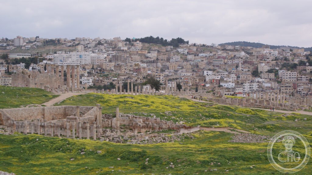
- The Cardo Maximus: the main north-south colonnaded street, 800 metres long, with original paving stones still in place (the chariot-wheel ruts are visible); a central water channel ran down the middle; the columns on both sides supported covered walkways with shops (tabernae); it is the most complete colonnaded main street in the Roman world
- The Temple of Artemis: the largest temple at Jerash (162 × 120 metres total precinct), dedicated to the city’s patron goddess Artemis; the 12-metre Corinthian columns of the main temple still stand; an engineering peculiarity: the column shafts were designed to sway in the wind without cracking (each column sits on a lead ball-and-socket joint at the base) — placing a knife blade between the plinth and the shaft reveals the flex on a windy day
- The South Theatre: capacity 3,000 seats; built in the 1st century AD; restored in the 1980s and used for performances; the city also had a North Theatre (council chamber, also restored) and a Hippodrome (240 × 52 metres, capacity 15,000) where Roman chariot races are now re-enacted for tourists
- The Hadrianic Arch: a triumphal arch built in 129–130 AD to honour the emperor Hadrian’s visit to Gerasa; 21 metres tall, at the south end of the site; the scale of the arch (larger than the Arch of Titus in Rome) reflects the importance of the imperial visit to a prosperous provincial city; the planned extension of the city south to match the arch’s location was never completed
- The Byzantine churches: Gerasa had at least 15 Christian churches by the 5th–6th century AD, most built over or adjacent to pagan temples; the Cathedral (built over a Temple of Dionysus), the Church of Saints Cosmas and Damianus (with original 6th-century mosaic floors in situ), and the Church of St Theodore are the most significant
- GPS: 32.2742° N, 35.8911° E
History
The site of Gerasa was settled in the Neolithic and Bronze Ages; significant occupation dates from the Hellenistic period (late 4th century BC) when the city was possibly founded by Alexander the Great’s generals or by Antiochos IV Epiphanes (c. 175 BC). The city was conquered by the Hasmonean king Alexander Jannaeus in 83 BC and by Pompey’s Roman legions in 63 BC; Roman rule marked the beginning of the city’s greatest period of growth. Gerasa was included in the Decapolis (a loose federation of ten Hellenised cities given special status by Rome) and benefited from Roman trade routes and patronage.
The city reached its peak population (estimated 15,000–50,000) in the 1st–3rd centuries AD; the major monuments (Oval Forum, Temple of Artemis, Cardo Maximus, South Theatre) were built during this period. Emperor Hadrian’s visit in 129–130 AD prompted a wave of construction; the Hadrianic Arch was built to mark the planned southern expansion of the city (which was never completed). The Severan dynasty (193–235 AD) produced the last major building campaign. The city declined in the late 3rd–4th centuries with the shift of trade routes to Palmyra and the empire’s military pressures.
Gerasa became a Byzantine Christian city in the 4th–7th centuries; the temples were gradually converted to churches. The city was taken by the Arab armies in 635 AD; a major earthquake in 749 AD destroyed much of the remaining inhabited area. The ruins were covered by the medieval Arab town of Jerash; systematic excavation began in 1925 under the auspices of various international expeditions; the site is still being excavated and new structures (including a large Byzantine bath complex) were discovered in the 2010s.
What you see
The site is entered from the south through the Hadrianic Arch, then the Hippodrome (where the JRA chariot racing re-enactments take place), then the South Gate into the walled city. The Oval Forum opens immediately inside the gate, its ellipse of Ionic columns framing the Temple of Zeus on the hill to the right; the spatial quality is unlike any other Roman forum and immediately explains why Jerash is the most impressive Roman provincial site outside Italy.
The Cardo Maximus (from the Forum northward to the North Gate) is the organisational spine of the visit; the column stumps and complete paving stones on both sides allow the imagination of the colonnaded street at full scale. The Temple of Artemis is the elevated focus (walk up the monumental staircase from the Cardo to the temple precinct) and the column-flex wind demonstration (push gently on a column base — the lead ball-and-socket is still functional) is genuinely surprising. The Jerash Archaeological Museum (inside the site) has good displays of the finds; the mosaics from the Byzantine churches (some in the museum, some in situ) are a separate highlight.
Practical information
- Admission: JOD 10 adult (approximately USD 14); Jordan Pass holders (a pre-purchased multi-site pass that includes most major Jordanian sites) enter free; open daily 8 am–6 pm (summer), 8 am–4 pm (winter)
- Getting there: from Amman (city bus from North Bus Station/Tabarbour, 45 minutes, JOD 0.5) or JETT tourist bus from Amman (1 hour); by car from Amman via the Jordan Valley Highway (48 km, 45 minutes); from Irbid (25 km north, 30 minutes by shared taxi)
- Combined itineraries: Jerash + Ajloun Castle (12 km west, Crusader/Ayyubid fortification, 12th century) makes an excellent half-day combination; Jerash + Umm Qais (Gadara, another Decapolis city, 60 km north) + Pella (another Bronze Age/Hellenistic site) is a full day
Getting there
From Amman North Bus Station (Tabarbour): city bus (45 minutes, JOD 0.5) or tourist JETT bus. By car from Amman: 48 km north via the Highway 35 (45 minutes). Nearest airport: Amman Queen Alia International (AMM) is 80 km south. GPS: 32.2742, 35.8911.
Nearby
- Petra — the Nabataean rock-cut city carved into the sandstone canyons of southern Jordan (250 km south of Jerash); the Treasury (Al-Khazneh), the Monastery, and the 800 surviving rock-cut tombs; UNESCO WHS and New Seven Wonder; the most visited site in Jordan
- Ajloun Castle — a 12th-century Islamic fortress built by Izz al-Din Usama (a nephew of Saladin) to guard the Jordan Valley crossings against the Crusader states; panoramic views from the hilltop; 12 km west of Jerash, 30 minutes by car
- Umm Qais (Gadara) — the northernmost Decapolis city, on a basalt plateau overlooking the Sea of Galilee, the Golan Heights, and the Yarmouk valley; the black basalt theatre, the colonnaded street, and the Museum of Umm Qais (in an Ottoman house); 60 km north of Jerash
Sources
- Wikipedia, Jerash, accessed June 2026
- Pauline Donceel-Voûte, “Les pavements des églises byzantines de Syrie et du Liban,” Publications d’histoire de l’art et d’archéologie de l’Université catholique de Louvain, 1988
- C.S. Fisher et al. (eds.), Gerasa: City of the Decapolis, American Schools of Oriental Research, 1938 — the foundational excavation report
- Zbigniew T. Fiema and Jérôme Freu, Petra – The Mountain of Aaron, Finnish Institute in the Middle East, 2008
Find it on the map
See this place and what’s around it →📷 Diventa un fotografo di Cultural Heritage Online
Condividi le tue foto dei luoghi: restano pubblicate con la tua firma come autore. Più vengono viste, più ti fai conoscere — e presto un concorso premierà le foto più apprezzate.
Accedi o registrati gratis per aggiungere una foto