Mont Saint-Michel
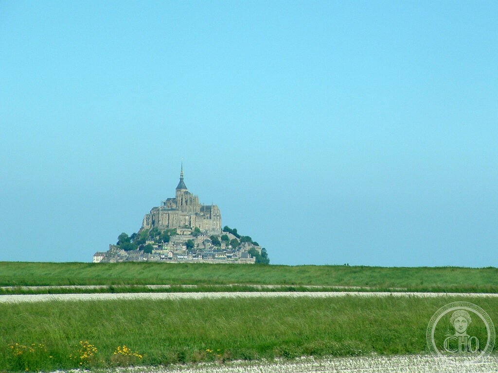
The most distinctive silhouette in France — a granite tidal island rising 92 metres above the bay of the same name in Normandy, crowned by a Gothic Benedictine abbey whose spire carries a gilded Archangel Michael visible from 50 kilometres, surrounded at its base by a medieval village that has been a place of pilgrimage since the 8th century and a place of tourism since the 19th, and accessible twice daily by the largest tides in Europe — which can still, if conditions are right, isolate the island completely within hours.
At a glance
Mont Saint-Michel (Breton: Menez Mikael, “Saint Michael’s Mount”) is a tidal island and commune in the Manche département, Normandy, France, located approximately 600 metres from the coast at low tide. The island covers 0.97 sq km and rises 92 metres above sea level; its highest point is the gilded copper statue of Archangel Michael on the spire of the Benedictine abbey. The abbey (officially: L’Abbaye du Mont Saint-Michel) was founded in 708 AD and expanded over eight centuries to its present form, which includes Romanesque nave, Gothic choir, and the “Merveille” (Marvel) — a double range of Gothic buildings added in the 13th century on the north face of the rock. The island village, with its medieval houses, ramparts, and ascending main street (the Grande Rue), is inhabited by fewer than 50 permanent residents. Over 2.5 million visitors come annually, making it the most visited site in France outside Paris. Mont Saint-Michel and its bay are a UNESCO World Heritage Site inscribed in 1979.
Key facts
- The tides: the bay of Mont Saint-Michel has some of the largest tidal ranges in Europe (up to 14 metres); the speed of the incoming tide (reported by some medieval sources as “the speed of a galloping horse” — an exaggeration, but tides can advance at 1–2 metres per second in the channels) makes walking in the bay without a guide dangerous; organised guided walks across the tidal flats are operated during low tide periods; the island is isolated by water for approximately 100 days per year
- The causeway and access: the original medieval pilgrim causeway was replaced in 1879 by a paved causeway that restricted tidal flow and silted up the bay; a new bridge-causeway opened in 2014 and restored tidal flow; the island is now reached on foot, by bicycle, or by shuttle bus from the mainland parking area (2.5 km); private vehicles are no longer permitted on the causeway
- The abbey church: the nave (11th–12th century Romanesque), the choir (15th–16th century Flamboyant Gothic), and the crypt of the Charnel House below; the Romanesque nave is one of the finest in Normandy; the Gothic choir was rebuilt after the original collapsed in 1421; the crossing tower was completed in 1521; the gilded copper statue of Archangel Michael by Emmanuel Frémiet was added to the spire in 1897
- La Merveille: the double row of Gothic buildings added to the north face of the rock in 1211–1228 by Abbot Jourdain; three stories on each of two adjacent buildings (six levels total), containing: the Guests’ Hall and Cloister (upper), the Knights’ Hall and Refectory (middle), the Cellar and Almonry (lower); the Cloister (upper level, open colonnade) and the Refectory (with its hidden windows illuminating the room from above) are the finest purely Gothic spaces in Normandy
- Military and prison history: the abbey served as a state prison from 1793 to 1863 (during and after the French Revolution); the prison held up to 700 political prisoners, including members of the Breton nationalist movement; the prison function ended when Victor Hugo and other writers campaigned for the restoration of the abbey as a monument historique
- Heritage: UNESCO World Heritage Site, Mont-Saint-Michel and its Bay, inscribed 1979
- GPS: 48.6361° N, 1.5115° W
History
The granite rock now occupied by the abbey was known in pre-Roman times as Mont Tombe (“Mount of the Tomb”); it was an island site used for pagan religious observance. The founding legend of the abbey dates from 708 AD, when Bishop Aubert of Avranches was instructed (three times) in a dream by Archangel Michael to build an oratory on the rock; the third time, the Archangel burned a hole in Aubert’s skull with his finger to communicate the urgency — the skull, with the supposed hole, is still on display in the treasury of the Basilica of Saint-Gervais in Avranches. The original oratory was replaced by a Carolingian sanctuary; a Benedictine monastery was established in 966 AD by Duke Richard I of Normandy.
The abbey grew to political and religious prominence in the 11th–13th centuries. The Normans, who had conquered England in 1066, were patrons of the abbey; William the Conqueror and subsequent English kings (the duchy of Normandy was held by English kings until 1204) made gifts to Mont Saint-Michel. The construction of “La Merveille” in 1211–1228 — during the reign of Philip II of France, who had just conquered Normandy from King John of England — was financed partly by Philip’s war reparations and transformed the abbey into one of the most ambitious Gothic construction projects of the period. During the Hundred Years’ War (1337–1453), Mont Saint-Michel was the only stronghold in Normandy never captured by the English; its garrison of 119 knights repelled attacks throughout the English occupation of Normandy.
The medieval pilgrimage route (the “Tro Breiz” and the “Voie de Tours”) brought pilgrims from across Brittany, Normandy, and England; a steady stream of people who had drowned or been caught by the tides gave the pilgrimage a reputation for danger that paradoxically increased its appeal. The pilgrimage declined after the French Revolution; the site was transformed by 19th-century tourism (including the paved causeway and the neo-Gothic spire added in 1897) into the object of mass tourism it remains today.
What you see
Mont Saint-Michel is best approached at different times of day: the silhouette at sunrise from the coastal road (D275) has a quality impossible to reproduce at midday; the island illuminated at night from the causeway is the image most people carry from their visit. The Grande Rue — the single ascending street from the gatehouse to the abbey entrance — is narrow, crowded in summer, and lined with restaurants and souvenir shops that have been there in some form since the medieval period; the commercial density is deliberately overwhelming and should be resisted: the abbey is the destination.
The abbey itself is remarkable for the experience of La Merveille: the Cloister (at the top of the north face, open to the sky, its double arcade of slender columns framing the sea and the bay beyond) and the Refectory below it (long and light-filled, its walls pierced by narrow lancets invisible from the entrance, the whole room illuminated from the side) are among the most precisely designed Gothic spaces in France. The guided tour (available in multiple languages, included in the ticket) explains the construction sequence; the audioguide is well-produced. The tidal flats on the south side of the island (accessible at low tide with a licensed guide from the tourist office in the village or from Avranches) provide a perspective on the island that no other viewpoint offers.
Practical information
- Admission: abbey €11 adult (free for under 18 and EU citizens under 26); open daily 9 am–6 pm (summer); 9:30 am–5 pm (winter); the village is free to enter; the shuttle buses from mainland parking are MXN 4 round trip (children free)
- Getting there: from Paris Montparnasse by TGV to Rennes (1.5 hours), then bus to Mont Saint-Michel (1 hour, operated by Keolis, one service/hour in peak season); by car from Paris (375 km, 4 hours via A11/N175); nearest airport: Dinard-Pleurtuit (DNR) 55 km, Rennes (RNS) 80 km, Paris Charles de Gaulle (CDG) 390 km
- Best strategy: stay one night on the island (accommodation expensive but the experience of the island at dawn and after the day-tourists leave is transformative); at minimum, arrive before 9 am or stay until after 7 pm when the shuttle buses reduce
Getting there
From Paris Montparnasse: TGV to Rennes (1.5 hours), then Keolis bus to Mont Saint-Michel (1 hour). By car from Paris via A11 and N175 (375 km, 4 hours). Nearest airport: Rennes (RNS) 80 km. The island is reached by shuttle bus or on foot from the mainland parking area. GPS: 48.6361, -1.5115.
Nearby
- Normandy D-Day Beaches — the landing beaches of 6 June 1944 (Omaha, Utah, Gold, Juno, Sword) stretch along 80 km of Normandy coast; the American cemetery at Colleville-sur-Mer (Omaha Beach, 9,387 graves) and the Mémorial de Caen are the principal memorial sites; 2–3 hours from Mont Saint-Michel by car
- Bayeux — the Norman cathedral city 70 km north-east of Mont Saint-Michel; the Bayeux Tapestry (strictly, a 70-metre embroidered linen narrative of the Norman Conquest, 1066–1077 AD) is the most important secular textile from the Middle Ages; displayed in the Centre Guillaume le Conquérant
- Saint-Malo — the corsair city on the Breton coast (45 km west); the intra-muros (walled city, virtually destroyed in 1944 and rebuilt) and the tidal beaches; the graves of the writer Chateaubriand and the cartographer Jacques Cartier; the Dinard resort town is just across the Rance estuary
Sources
- Wikipedia, Mont Saint-Michel, accessed June 2026
- UNESCO, Mont-Saint-Michel and its Bay, WHS reference 80, inscribed 1979
- Lucien Bély (ed.), Le Mont-Saint-Michel: histoire et imaginaire, Éditions du Patrimoine, 1998
- Jean Decaëns, Mont-Saint-Michel, Éditions Ouest-France, 2010 — the standard popular guide with architectural drawings
Find it on the map
See this place and what’s around it →📷 Diventa un fotografo di Cultural Heritage Online
Condividi le tue foto dei luoghi: restano pubblicate con la tua firma come autore. Più vengono viste, più ti fai conoscere — e presto un concorso premierà le foto più apprezzate.
Accedi o registrati gratis per aggiungere una foto