Mesa Verde
The most significant concentration of Ancestral Puebloan heritage in the United States — a high plateau in south-west Colorado where hundreds of multi-storey stone dwellings are tucked into the natural alcoves of sandstone cliffs, culminating in the Cliff Palace, a 150-room communal dwelling that its builders abandoned in a single generation around 1300 AD and never returned to.
At a glance
Mesa Verde National Park is a federal archaeological preserve covering 210 sq km of the Mesa Verde plateau in Montezuma County, south-western Colorado, near the Four Corners region where Colorado, Utah, Arizona, and New Mexico meet. The park protects over 5,000 known archaeological sites, including 600 cliff dwellings built by the Ancestral Puebloans (formerly called the Anasazi) who inhabited the plateau from approximately 600 AD to 1300 AD. The cliff dwellings — built in the natural alcoves of the Mancos Shale cliffs under the mesa’s sandstone caprock — range from single-room storage units to the 150-room, 23-kiva Cliff Palace, the largest cliff dwelling in North America. The park was established in 1906 (the first national park in the USA created to protect an archaeological resource) and inscribed as a UNESCO World Heritage Site in 1978.
Key facts
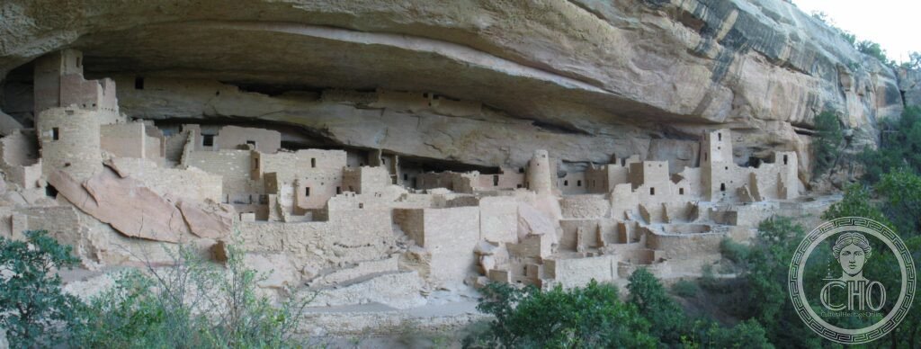
- Cliff Palace: the largest and most complex cliff dwelling in North America; 150 rooms and 23 kivas (circular underground ceremonial chambers) built into a 90-metre long and 27-metre deep natural alcove; population at peak estimated at 100–120 people; construction period c. 1190–1280 AD; the multi-storey stone towers, the distinctive T-shaped doorways, and the ground-level plazas are the key architectural features; tours are guided only (ranger-led, ticket required)
- Balcony House: a 40-room dwelling on the south-facing cliff of Soda Canyon; distinctive for its access route (visitors must climb a 9-metre ladder, crawl through a narrow tunnel, and climb down two more ladders); the degree of difficulty is believed to be intentional, making the dwelling defensible; the site name refers to the long balcony-like porch above the main entrance; guided tours only
- Spruce Tree House: the third-largest cliff dwelling at Mesa Verde, 114 rooms and 8 kivas; currently accessible for self-guided tours (the only cliff dwelling at the park that is); the best-preserved kiva (with reconstructed roof and ladder access) allows visitors to descend into the interior
- Kivas: circular underground ceremonial chambers used for religious and social functions; each had a central fire pit, a ventilation shaft, a sipapu (a small hole representing the underworld through which ancestors emerged), and seating ledges; the presence of many kivas at the major cliff dwellings suggests intense ceremonial activity in the final period of occupation
- Abandonment c. 1300 AD: the entire mesa was abandoned within approximately one generation around 1276–1300 AD; the cause is debated — a severe 26-year drought (documented by tree ring analysis) coincided with social unrest and resource depletion; the Ancestral Puebloans moved south to the Rio Grande valley and the Pueblo communities of Arizona and New Mexico, where their descendants (the modern Pueblo peoples) still live
- Heritage: UNESCO World Heritage Site, Mesa Verde National Park, inscribed 1978
- GPS: 37.1840° N, 108.4888° W
History
The Mesa Verde plateau was first settled by the Ancestral Puebloans around 600 AD; the early period (Modified Basketmaker period, 600–750 AD) saw small villages of pit houses on the mesa top. The Developmental Pueblo period (750–1100 AD) brought above-ground stone architecture; the villages grew in size and the characteristic D-shaped or circular great kivas appeared. The peak period (Classic Pueblo, 1100–1300 AD) saw the shift to cliff dwellings in the alcoves below the mesa rim — a move whose cause is debated but probably involved defensive concerns, the superior thermal properties of south-facing cliff alcoves (warm in winter, shaded in summer), and proximity to springs in the canyon walls.
The cliff dwellings were constructed and occupied for only about a century before the abandonment around 1276–1300 AD. The 26-year drought (1276–1299) documented in the tree ring record was the most severe in the region in centuries; combined with evidence of conflict (skeletal remains with violence marks, stored food caches, defensive architecture) and resource depletion (game and fuel wood exhaustion), the abandonment appears to have been a response to simultaneous environmental and social pressures. The people who left did not disappear: they moved south to join the Hopi, Zuni, and Rio Grande Pueblo communities, where oral traditions preserve memory of the ancestors who came from the north.
The cliff dwellings were rediscovered by Anglo-American ranchers Richard Wetherill and Charlie Mason on 18 December 1888, when they rode across the mesa in a snowstorm and suddenly saw Cliff Palace in the canyon below — a perfectly preserved stone city no one of their culture had seen for 600 years. Wetherill conducted excavations and sold objects to collectors; the concerned response from eastern US academics and politicians led to the Mesa Verde Act of 1906, establishing the park and making it the first national park in the US created specifically to protect archaeological sites.
What you see
The park entrance is 10 km east of Cortez on US Route 160; the visitor centre and Chapin Mesa Museum are 22 km from the entrance. The main loop road on Chapin Mesa gives access to overlooks and the three major cliff dwellings. Cliff Palace is accessible only on ranger-led tours (April–October, tickets sold at the visitor centre); tours involve a 100-metre descent by trail and ladders, then a climb back up. The dwelling itself, seen from the lower plaza, presents a fully three-dimensional urban complex: towers, room blocks three storeys high, kiva roofs (reconstructed) at ground level, the red-painted mortar between the stones, and T-shaped doorways leading to interior rooms that could be observed (but not entered) through the openings.
Balcony House requires the most physical commitment of the ranger-led tours: the ladder and tunnel access is not claustrophobic but is narrow and vertical; the effect on arrival at the dwelling — sheltered from above by 9 metres of sandstone overhang, facing south across Soda Canyon, with the afternoon sun warming the plazas — is unusually intimate for an archaeological site. The sense of an inhabited place is stronger here than at Cliff Palace, partly because the scale is domestic.
Practical information
- Admission: $35 per vehicle (national park fee; America the Beautiful annual pass valid); Cliff Palace and Balcony House tours require additional tickets ($6 per person) sold at the visitor centre; book in advance in summer as tours sell out
- Season: the park is open year-round; cliff dwelling tours run April–October only; in winter (November–March), visitors can walk to overlooks and see the dwellings from above but cannot enter
- Getting there: Cortez, CO (10 km west of the park entrance) is the nearest town; Durango Regional Airport (DRO) is 60 km east (1 hour); Denver International Airport (DEN) is 490 km north-east (5 hours); there is no public transport to the park — a car is necessary
- Altitude: the park ranges from 2,100 to 2,600 metres; altitude sickness is possible for visitors coming directly from sea-level locations; Durango (1,980 m) is a good overnight acclimatisation stop
Getting there
The park entrance is 10 km east of Cortez, CO, on US Route 160. No public transport serves the park; a car is required. Durango Regional Airport (DRO) is 60 km east; nearest major hub is Denver (DEN), 490 km north-east. GPS: 37.1840, -108.4888.
Nearby
- Chaco Culture National Historical Park — the great-house ceremonial complex of the Chacoan period (850–1150 AD), the predecessor of the Mesa Verde cliff dwellings in terms of cultural influence; Pueblo Bonito (800 rooms) is the largest ancient building in the American Southwest; UNESCO WHS; 200 km south-east in New Mexico (3 hours from Mesa Verde)
- Canyon de Chelly National Monument — a canyon in the Navajo Nation with Ancestral Puebloan cliff dwellings and later Navajo history; the White House Ruin trail is the only self-guided hike to a cliff dwelling in the park; all other tours require a Navajo guide; 230 km south-west of Mesa Verde in Arizona
- Durango — a Victorian-era silver mining town 60 km east; the Durango & Silverton Narrow Gauge Railroad is a vintage steam train running through the San Juan Mountains to Silverton; one of the best heritage railway experiences in the USA; 60 km east of Mesa Verde
Sources
- Wikipedia, Mesa Verde National Park, accessed June 2026
- UNESCO, Mesa Verde National Park, WHS reference 27, inscribed 1978
- Linda Martin Alcoff, ed., Mesa Verde and the Four Corners Region, University of New Mexico Press, 2005
- David Grant Noble, Ancient Ruins of the Southwest: An Archaeological Guide, Northland Publishing, 2000
Find it on the map
See this place and what’s around it →📷 Diventa un fotografo di Cultural Heritage Online
Condividi le tue foto dei luoghi: restano pubblicate con la tua firma come autore. Più vengono viste, più ti fai conoscere — e presto un concorso premierà le foto più apprezzate.
Accedi o registrati gratis per aggiungere una foto