Çatalhöyük
A 9,000-year-old proto-city in southern Anatolia where up to 8,000 people lived in mud-brick houses with no streets — entering their homes through roof hatches, burying their dead beneath the sleeping floor.
At a glance
Çatalhöyük is one of the best-preserved and most intensively studied Neolithic settlements in the world. Located in the Konya Plain of south-central Anatolia, the site consists of two mounds — East and West — built up over nearly two millennia of continuous occupation. At its height, between approximately 7000 and 6200 BC, the East Mound housed a population of 3,500 to 8,000 people in a dense agglomeration of mud-brick rooms, with no streets, no central plaza, and no discernible hierarchy of structures. The site is celebrated for its wall paintings, clay figurines, and for the evidence it provides of the transition from nomadic hunter-gatherer life to settled, agricultural community. Inscribed on the UNESCO World Heritage List in 2012.
Key facts
- Period: c. 7500–5700 BC (Neolithic and early Chalcolithic)
- Discovery: Excavations begun by James Mellaart, 1958–1965; continued by Ian Hodder from 1993 to present
- Scale: East Mound 13.5 hectares; West Mound (later, c. 6000–5500 BC) 8 hectares; 18 occupation levels identified
- Status: UNESCO World Heritage Site (2012); active excavation continues
- Access: Visitor centre and walkways on the East Mound; open to the public
History
The first evidence of Çatalhöyük’s existence reached the wider world in the late 1950s, when British archaeologist James Mellaart identified the two mounds in the Konya Plain and began systematic excavations in 1961. What emerged was unlike anything previously known from the Neolithic: a settlement of extraordinary density and complexity, occupied continuously for approximately 1,800 years. Mellaart’s excavations uncovered dozens of houses, hundreds of burials, elaborate wall paintings, and the clay figurines that would later become among the most reproduced images of prehistoric art — particularly a seated female figure, broad-hipped and powerful, interpreted by Mellaart as a mother goddess and by subsequent scholars in more contested terms.
Mellaart’s work ended in controversy in 1965, and the site remained unexcavated for nearly three decades. In 1993, Ian Hodder of Cambridge University reopened the project under the banner of reflexive archaeology — an approach that documented not only what was found but the process and interpretation of finding it. Hodder’s teams introduced isotopic analysis, micromorphology, and systematic zooarchaeology, producing a picture of Çatalhöyük’s inhabitants as people who moved seasonally, ate a mixed diet of cultivated and wild foods, and organised their social world through the household rather than through any centralised authority.
The dead were interred beneath the floors of the houses in which they had lived — under sleeping platforms, beneath hearths, occasionally in clusters of multiple generations. Analysis of the skeletons shows that individuals often lived their entire lives within a very small geographical range, and that the population was remarkably egalitarian: few burials contain significant wealth differentiation. The houses themselves were rebuilt repeatedly on the same footprint, each new structure rising directly on the filled-in remains of the old, creating the characteristic tell mound that is still visible from the Konya Plain today.
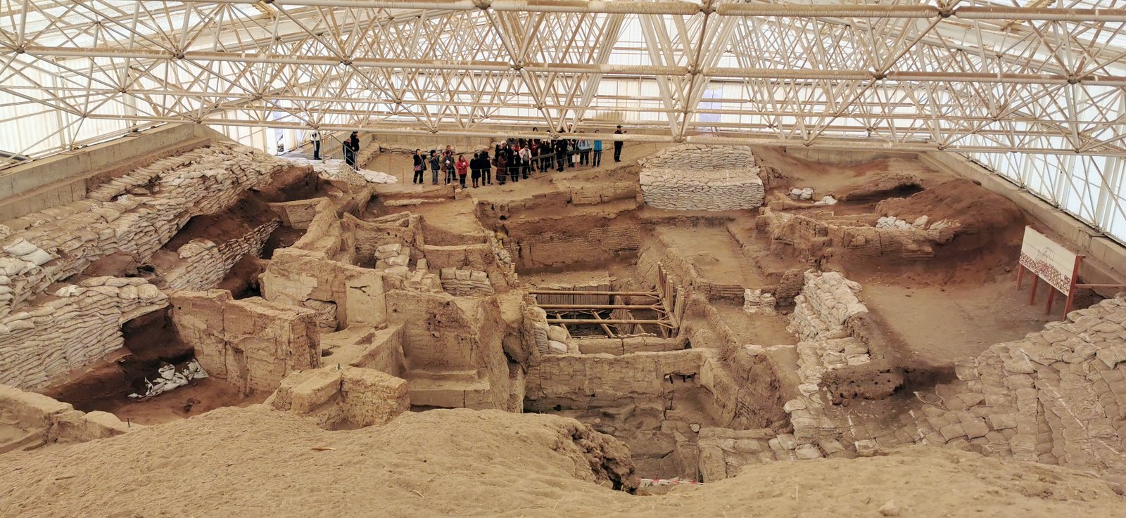
What you see
Walking the East Mound at Çatalhöyük means reading a city in horizontal cross-section. The houses — rectangular, approximately 25 square metres on average — were built directly against their neighbours, sharing walls, with no gaps between them. Entry was through a hole in the flat roof, reached by a wooden ladder; the same hole served as the primary light source and chimney. Inside, the main room contained a hearth, an oven, storage bins built into the walls, and raised sleeping platforms. Beneath the platforms, the soil still conceals the bones of the previous inhabitants. The walls of the more elaborate houses were replastered dozens of times; in some cases the paintings — geometric bands, hands in red ochre, hunting scenes, vultures descending on headless human figures — were applied to fresh plaster, covered over, and repainted in a cycle that spanned decades.
The visitor shelters on the East Mound protect the most significant excavated areas and allow close inspection of the architectural sequence. Looking down into the excavation trenches, the layers of superimposed buildings are visible as compressed striations of mud brick, ash, and compacted fill — 18 levels of occupation stacked one on top of the other like geological strata, each representing a century or more of continuous habitation.
Practical information
- Opening hours: Daily 08:30–17:30 (winter); 08:30–19:00 (summer); closed during severe weather
- Best season: April–June and September–October; summers are hot on the open plain (35°C+)
- Duration: 2–3 hours including visitor centre and mound walkways
- Notes: The visitor centre houses casts and explanatory materials; original artefacts are in Ankara and Konya. Bring sun protection — the site is entirely exposed.
Getting there
The nearest city is Konya, approximately 52 km northwest of the site. Konya is served by domestic flights from Istanbul and Ankara. From Konya, the site is accessible by taxi or organised tour; there is no regular public bus directly to Çatalhöyük. Key artefacts, including the famous seated figurines, are on display at the Museum of Anatolian Civilizations in Ankara and the Konya Regional Archaeological Museum.
Nearby
- Konya Regional Archaeological Museum — 52 km; major Çatalhöyük artefact collection
- Karatay Medrese (Konya) — 13th-century Seljuk tile museum in Konya city centre
- Mevlana Museum (Konya) — mausoleum and museum of Rumi, founder of the Mevlevi order
Sources
- Wikipedia: Çatalhöyük
- UNESCO World Heritage Centre: Neolithic Site of Çatalhöyük
- Çatalhöyük Research Project, University of Cambridge
Find it on the map
See this place and what’s around it →📷 Diventa un fotografo di Cultural Heritage Online
Condividi le tue foto dei luoghi: restano pubblicate con la tua firma come autore. Più vengono viste, più ti fai conoscere — e presto un concorso premierà le foto più apprezzate.
Accedi o registrati gratis per aggiungere una foto