
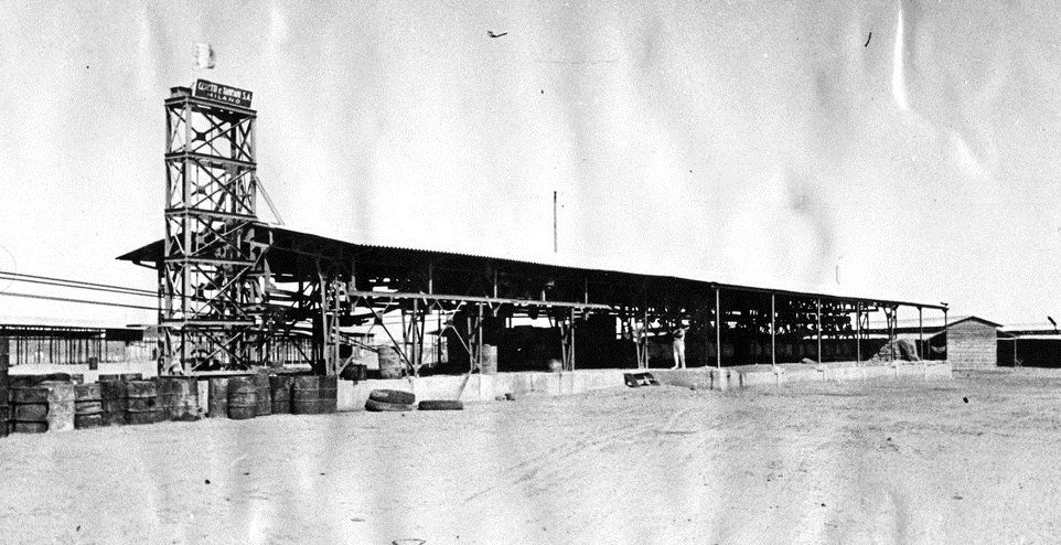
Seventy-two kilometres of aerial line from the Red Sea to 2,326 metres: the longest cableway in the world at its completion in 1937. Stripped for war reparations in the 1940s, scrapped by the 1980s, it survives as a photographic record.
At a glance
The teleferica was the third and strangest of the three Italian transport lines between Massawa and Asmara, alongside the road and the mountain railway. Built in 1935–1937 by the Milanese firm Ceretti & Tanfani, it ran 71.8 kilometres from the port to the highland capital at 2,326 metres — at its inauguration the longest cableway ever constructed, at a time when nothing else in the world passed 35 kilometres. Its 1,540 gondolas, driven by diesel engines, could move 30 tonnes of freight per hour in each direction. The British administration dismantled its machinery as war reparations after 1941; the iron towers went for scrap in the 1980s.
Key facts
- Builder: Ceretti & Tanfani S.A., Milan; built 1935–1937
- First section: Ghinda–Godaif, 26.6 km, opened August 1936; full line complete in 1937
- Length: 71.8 km, from sea level at Massawa to 2,326 m at Asmara — the longest cableway in the world at its completion
- Capacity: 30 tonnes per hour in each direction, in 1,540 gondolas, on nearly thirty sections of bearing cable driven by diesel engines
- Steel: about 1,000 t of mechanical parts, 1,000 t of cables, and nearly 2,000 t of structural steelwork
- End: engines, cables and equipment removed by the British administration (1941–1952) as war reparations; remaining towers scrapped in the 1980s
History
The context, stated plainly: the cableway was war logistics. It was ordered as Italy massed men and material through Massawa for the invasion of Ethiopia, and its purpose was to multiply the freight capacity of the corridor between the port and the highlands — the lifeline of the colonial build-up. Like every work in this series, it is documented here as part of that record.
As engineering, it was a record-breaker. The line climbed the escarpment in nearly thirty cable sections, its trestle towers stepping up the same gorges the railway negotiates in spirals below. A first stretch between Ghinda and Godaif opened in August 1936; the full 71.8 kilometres entered service in 1937, moving up to 30 tonnes an hour each way — modest per gondola, relentless in aggregate, day and night, independent of road and rail. Nothing approaching its length existed anywhere in the world.
It worked for barely four years. After the British took Eritrea in 1941, the administration removed the diesel engines, the steel cables and much of the equipment as war reparations. The line never ran again. The towers stood as rusting markers along the escarpment until they were scrapped in the 1980s; today the teleferica survives in photographs, in the builder’s own illustrated brochure, and in scattered foundations along the old alignment.
What the photographs show
The record shows an infrastructure of almost graphic simplicity: latticed steel trestles — single and doubled, with counterweights — marching over valleys and above the road at Nefasit; strings of bucket-sized gondolas hanging from the cables; and at the Asmara end, the terminal at Campo Marte, a long open shed under a steel tower carrying the constructor’s sign. The aggregate numbers are the architecture here: a thousand tonnes of machinery, a thousand of cable, two thousand of steelwork, strung across seventy kilometres of desert and mountain.
Read against the Massawa and Asmara it connected, the teleferica is the missing middle piece of Italian Eritrea’s infrastructure triad — the one that did not survive to be photographed in colour.
The site today
- There is no monument to visit: the line is gone, and its traces along the escarpment are fragmentary.
- The story is best encountered in Asmara and Massawa themselves, and along the mountain road and railway that still climb the same corridor.
Where it ran
The line linked the port of Massawa with Asmara’s southern edge; the first completed section ended at Godaif, on the capital’s outskirts, and the terminal stood at Campo Marte. Reference point (Godaif, Asmara): GPS 15.30598, 38.92307 · Open in Google Maps.
Related places and reading
- Italian Eritrea: Asmara, the Modernist Capital, and the Road to the Sea — the wider frame
- Asmara — the highland terminus, UNESCO-listed modernist city
- Massawa — the Red Sea port where the line began
Sources
- English Wikipedia, “Asmara-Massawa Cableway” (builder, dates, length, capacity, tonnages, British dismantling, 1980s scrapping).
- Ceretti & Tanfani, La Teleferica Massaua-Asmara, illustrated company brochure (via Wikimedia Commons, including the Campo Marte terminal photograph).
- Our article “Italian Eritrea” (construction 1935–1937, world-record status, capacity), fact-checked separately.
- OpenStreetMap Nominatim (Godaif reference coordinates).
Find it on the map
See this place and what’s around it →Record researched and written by Luigi De Marchi for Cultural Heritage Online, 2026.

📷 Become a Cultural Heritage Online photographer
Share your photos of places: they stay published under your name as the author. The more they're seen, the more you get noticed — and soon a contest will reward the most appreciated photos.
Log in or sign up free to add a photo