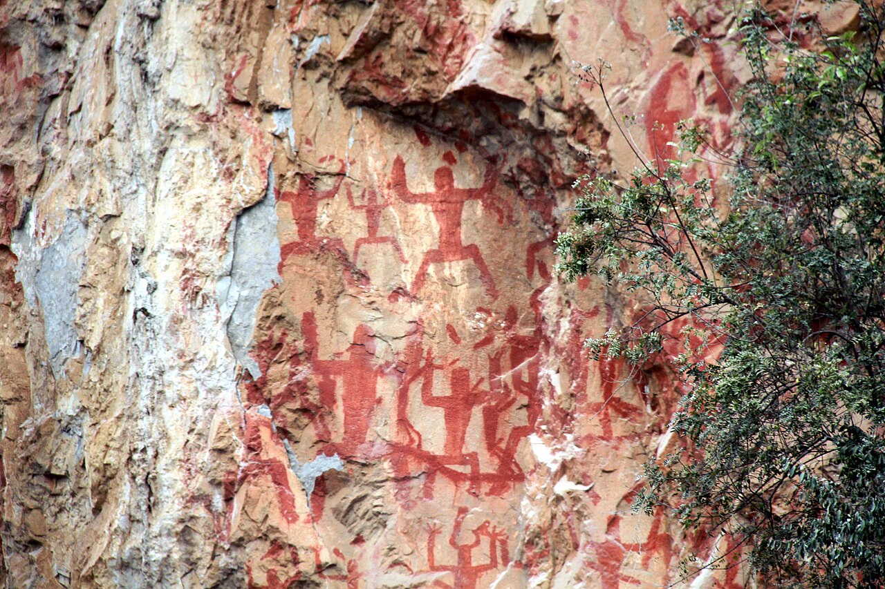
The Zuojiang Huashan Rock Art Cultural Landscape in Chongzuo, Guangxi Zhuang Autonomous Region, was inscribed as UNESCO World Heritage in 2016, covering 38 sites along 105 kilometres of river cliff on the Zuojiang (Left River) and its tributary the Mingjiang, containing approximately 1,900 painted figures in red ochre produced between approximately 500 BCE and 200 CE. The pigment is a mixture of haematite, animal fat and water, applied to near-vertical limestone cliff faces above the waterline; several figures reach 12 metres in height and occupy positions accessible only by rope from above or below. The site is 200 kilometres southwest of Nanning, the regional capital, and is positioned at the intersection of routes connecting southern China with Southeast Asia, placing it within reach of four distinct UNESCO inscriptions that span the Pearl River Delta, the northern Guangxi limestone highlands and the Vietnamese borderlands.
East and north: Kaiping Diaolou and South China Karst at Guilin Kaiping 400 km east, 4h bus Nanning to Guangzhou then 2h to Kaiping; Guilin 450 km northeast of Nanning, 3h HSR Nanning to Guilin
The Kaiping Diaolou and Villages in Guangdong Province, inscribed as UNESCO World Heritage in 2007, are approximately 400 kilometres east of Chongzuo, reachable most conveniently by high-speed rail from Nanning East to Guangzhou South (approximately 2 to 2.5 hours) and then by bus or rail from Guangzhou to Kaiping (approximately 1.5 to 2 hours). Kaiping is in the Pearl River Delta region of western Guangdong, approximately 130 kilometres southwest of Guangzhou. The inscription covers 1,833 diaolou (fortified watchtower-residences) and four villages (Zili, Majianglong, Jinjiangli and Sanmenli) in the Kaiping and Chikan area. The diaolou were built primarily between the 1880s and the 1930s by Kaiping emigrants who had prospered in gold-rush California, British Columbia, Australia and Southeast Asia and returned to construct defensible family residences that blended Chinese vernacular domestic planning with European and North American architectural ornament. The buildings are hybrids: a Chinese courtyard organisation and feng shui siting on the exterior, with Renaissance arched loggias, Baroque towers, Romanesque columns, Art Deco roof parapets and Gothic window tracery applied as surface decoration. The purpose of the diaolou form — a watchtower with gun ports and reinforced concrete walls up to 60 centimetres thick — was defensive against the banditry and warlord violence that characterised the Pearl River Delta in the Republican period (1912–1949 CE); the combination of overseas wealth and rural insecurity produced a building type with no direct parallel elsewhere in China. The connection between Kaiping and the Zuojiang Huashan Rock Art lies in the Lingnan region’s continuous role as a corridor between the Chinese interior and Southeast Asia: the Zhuang people of Guangxi, whose ancestors are the likely authors of the Huashan paintings (based on ethnographic parallels between the painted figures and documented Zhuang ritual imagery of the first millennium BCE), and the Guangdong emigrants who built the Kaiping diaolou both participated in the long-distance mobility that characterises this geographic corridor between southern China and the wider Pacific.
The South China Karst, inscribed as UNESCO World Heritage in 2007 and 2014, includes the Guilin–Lijiang cluster in northern Guangxi approximately 450 kilometres northeast of Nanning (3 hours by high-speed rail from Nanning to Guilin on the Nanning–Guangzhou HSR line). The Guilin section of the inscription covers the fenglin (peak forest) karst of the Lijiang River corridor from Guilin south to Yangshuo, a 90-kilometre stretch of river flanked by approximately 20,000 individual limestone towers rising 100 to 500 metres above the alluvial plain, formed by the chemical dissolution of Devonian-period limestone over several million years in a tropical and subtropical climate with high rainfall. The Guilin–Yangshuo river landscape is the most reproduced Chinese landscape in traditional painting and is depicted in the design of the 20 CNY banknote. The Lijiang River cruise from Guilin Zhujiang Wharf to Yangshuo (approximately 83 kilometres, 4 to 5 hours by tourist boat) passes the densest concentration of the designated karst formations; the most photographed individual peak is the Yellow Cloth Shoal (Huangbu Tan), where the river shallows to a ford surrounded by seven mirrored towers at approximately the midpoint of the cruise. The Zuojiang rock art and the Guilin karst share the same geological substrate: the entire Guangxi basin is underlain by Devonian and Carboniferous limestone, and the cliff faces on which the Huashan paintings are applied are the same type of limestone dissolution surfaces as the karst formations of the Guilin landscape, the Zuojiang cliffs simply being in a lower, more dissected part of the drainage system.
East and cross-border: Historic Centre of Macao and Ha Long Bay (Vietnam) Macao 500 km east, 5h HSR Nanning to Guangzhou then 2.5h ferry; Ha Long Bay 300 km south via Vietnam — cross-border context, not a day trip
The Historic Centre of Macao, inscribed as UNESCO World Heritage in 2005, is approximately 500 kilometres east of Chongzuo, reachable by high-speed rail from Nanning East to Guangzhou South (approximately 2 to 2.5 hours) and then by ferry from Guangzhou Nansha Port to Macao (approximately 1 hour), or alternatively by high-speed rail to Zhuhai (approximately 2.5 hours from Nanning) and then by the Macao Outer Harbour ferry terminal (15 minutes). The inscription covers 22 buildings and open spaces in the historic urban core of Macao peninsula, representing 400 years of continuous Portuguese colonial presence from 1557 CE (the establishment of the Portuguese trading settlement) to the 1999 handover to China. The ensemble includes the ruins of St. Paul’s (the façade and crypt of the Jesuit church of Máter Dei, destroyed by fire in 1835 CE; the southern baroque stone façade, 23 metres wide, was built 1602–1637 CE under the direction of Japanese Christian exiles and Chinese craftsmen, making it a unique artifact of the Jesuit Asian mission’s architectural production), the Fortaleza do Monte (built 1617–1626 CE on the highest point of Macao peninsula as the principal defence of the Portuguese colony), the A-Ma Temple (a syncretic Chinese folk religion temple dedicated to the goddess Matsu, documented from at least the 16th century and the site from which the Portuguese name “Macao” — a corruption of A-Ma-Gao, “Bay of A-Ma” — derived), and the Senate Square (Largo do Senado) paved with black-and-white Portuguese calçada paving in a wave pattern. The connection between Macao and the Zuojiang Huashan Rock Art is the Pearl River Delta’s role as the primary historic interface between Chinese civilisation and maritime Southeast Asia: the same geographic corridor that allowed the Zhuang culture of Guangxi to develop trade and cultural connections southward toward Vietnam and the Gulf of Tonkin from the first millennium BCE was later the entry point for Portuguese and Spanish maritime trade from the 16th century CE onward.
Ha Long Bay in the Gulf of Tonkin, Vietnam, inscribed as UNESCO World Heritage in 1994 and extended in 2000, is approximately 300 kilometres south of Chongzuo by road via the Friendship Pass (Youyi Guan) border crossing into Vietnam, and then southeastward through Lang Son and Hanoi (approximately 4 hours from the border) to Ha Long City (approximately 2 further hours from Hanoi). The total road distance from Chongzuo to Ha Long Bay is approximately 700 kilometres, making a direct visit impractical as a day trip and most easily undertaken as a separate multi-day itinerary from the Nanning or Hanoi end. Ha Long Bay’s 1,553 islands and islets in the Gulf of Tonkin are limestone karst formations of the same geological origin and age as the Guilin–Zuojiang karst of Guangxi: both are relict karst landforms produced by the chemical weathering of Devonian and Carboniferous limestone, with the Vietnamese formations representing the seaward, partially submerged continuation of the same geological belt that produced the Guangxi highlands. This direct geological continuity makes Ha Long Bay the oceanic counterpart of the Guilin and Zuojiang landscapes, sharing the tower karst and karst island morphology in a marine rather than freshwater context. The 1,900 Huashan paintings, produced by a culture that used the Zuojiang waterway as a primary axis of movement, were thus painted on the same rock type that forms the islands visible from the Vietnamese coast 300 kilometres to the south, a geographic and geological context that situates the Zhuang rock art tradition within the broader limestone landscape of the entire northern Gulf of Tonkin rim.
Practical information
The Zuojiang Huashan Rock Art is visited by boat from Ningming County, approximately 70 kilometres south of Chongzuo city and 170 kilometres from Nanning. From Nanning Railway Station or Nanning East High-Speed Railway Station, buses to Ningming take approximately 2 to 2.5 hours; a taxi from Ningming to the Huashan boat dock takes approximately 20 minutes. Boat tours depart from the Mingjiang River dock at Mingshi and travel approximately 30 kilometres upstream to the principal Huashan cliff face, the tour lasting approximately 2 to 3 hours on the water. The most prominent single painting, at the Huashan (Painted Mountain) main site, measures approximately 172 metres across its full extent along the cliff face; the largest individual figure at this site is approximately 3 metres high, and the tallest figures across all 38 sites reach 12 metres. The painting pigment (a mixture of haematite, animal fat and water, confirmed by analysis) has survived on exposed outdoor limestone cliff faces for 2,000 to 2,500 years because the overhanging rock provides protection from direct rainfall. Admission to the boat tour is approximately 238 CNY (including the entrance fee and boat transport). The best season for the Zuojiang visit is October to April, before the summer monsoon raises river levels and reduces visibility of the lower painting panels; summer temperatures in Guangxi regularly exceed 35°C with high humidity. Nanning has direct high-speed rail to Guangzhou (2 to 2.5 hours), Guilin (3 hours), Beijing (8 hours via HSR) and Kunming (3.5 hours). The Friendship Pass border crossing to Vietnam at Pingxiang (80 kilometres south of Nanning) provides road access toward Hanoi for travellers continuing into the Ha Long Bay area.
Frequently Asked Questions
Who painted the Zuojiang Huashan figures, and what do the images depict?
The painters of the Zuojiang Huashan rock art have not been identified by any contemporary documentary source, as no writing system was in use by the population of the Zuojiang basin during the period of production (approximately 500 BCE to 200 CE). The scholarly consensus, based on ethnographic comparison with documented Zhuang ritual imagery, the geographic distribution of the sites within territory historically associated with the Luoyue people (a branch of the Baiyue people documented in Han-dynasty Chinese sources as the principal population of Guangxi), and the continuity of certain painted motifs with symbols used in Zhuang textile and ceremonial art into the 20th century, is that the paintings were produced by the ancestors of the modern Zhuang people (zhuangzu), who are today the largest ethnic minority in China with a population of approximately 19 million concentrated in Guangxi. The figures depicted fall into several categories: large frontal human figures with bent knees and raised arms (sometimes interpreted as a ritual dance posture, similar to postures documented in Dong Son bronze drum decoration from Vietnam and southern China of the same period); smaller human figures in profile; animals including dogs, birds and what appear to be horses; bronze drums (a high-status ceremonial object of the Dong Son cultural sphere); and geometric symbols whose meanings have not been established. The largest figures — those reaching 10 to 12 metres in height — occupy the most prominent positions on the cliff faces and are consistently interpreted as supernatural or divine beings, with the surrounding smaller figures as worshippers or attendants. Local oral tradition recorded by Chinese ethnographers in the 20th century attributes the pigment mixture to haematite mixed with human blood and animal fat, a claim that modern chemical analysis has not fully confirmed (the organic component of the binder has degraded); the oral tradition may preserve a memory of a ritual significance to the materials used.
How were the Huashan paintings applied to cliff faces that are not accessible without modern equipment?
The logistics of painting the Zuojiang Huashan figures, particularly those reaching 12 metres in height on near-vertical cliff faces above the river and with no accessible ledges or horizontal surfaces above or below them, have been a subject of scholarly inquiry since the first academic documentation of the sites in the 1950s. Three main hypotheses have been proposed. The first, and most technically plausible, is that the painters worked from bamboo rafts or flat-bottomed wooden boats that could be positioned against the cliff face at varying water levels; the Zuojiang is a navigable river and the paintings are distributed between approximately 2 and 50 metres above the current low-water line, with most of the larger figures concentrated between 5 and 20 metres above the water. The river level would have varied seasonally by several metres, potentially allowing a single dry-season low-water figure to be painted in stages as the water level changed; this theory is supported by the concentration of sites on concave cliff faces (where a boat could be held against the rock) rather than on convex or exposed faces. The second hypothesis is bamboo scaffolding erected against the cliff face, a technology well within the capacity of the period; bamboo structures of comparable scale are documented in Southeast Asian construction practice from the first millennium BCE. The third hypothesis, not generally favoured in the academic literature, involves rope descent from the cliff top; this is structurally implausible for the largest figures, which extend too far below the cliff edge and too wide laterally to be painted from above. The high precision and consistent internal scale of individual figures suggests the painters had stable working platforms rather than working in motion; the exact method remains undetermined.
What is the relationship between the Zuojiang Huashan rock art and the Dong Son bronze drum tradition of Southeast Asia?
The Dong Son culture, centred on the Ma River valley in what is now northern Vietnam but distributed across a wide area including southern China, the Malay Peninsula and the Indonesian archipelago from approximately 700 BCE to 200 CE, is the archaeological culture most closely associated with the Zuojiang Huashan paintings in terms of both chronology and geographic distribution. The Dong Son culture is defined primarily by its bronze drums (trong dong), large cast-bronze ceremonial drums decorated with geometric patterns, dancing human figures with feathered headdresses, boats, birds and concentric circles on the tympanum, which were produced in the Ma River valley and traded or gifted across a territory encompassing modern Vietnam, Laos, Cambodia, Thailand, Malaysia and the island of Sumatra. More than 200 Dong Son bronze drums have been found within Guangxi Province, concentrated in the Zuojiang and Yujiang river basins where the Huashan paintings are located; the painted figures on the Huashan cliffs include representations of what are convincingly identified as Dong Son bronze drums (circular objects with concentric rings and a central star pattern matching known drums), and the posture of the large frontal human figures with raised arms and bent knees matches the posture of the dancing human figures on Dong Son drum tympana. This visual and material correspondence suggests that the Huashan painters were participants in the same cultural sphere that produced the Dong Son bronze drums, whether as manufacturers, recipients or cultural inheritors of the tradition. The connection also explains the spatial logic of the painting locations: the Zuojiang is a navigable waterway leading toward the Gulf of Tonkin and the Dong Son heartland in northern Vietnam, and the cliff-face paintings were positioned to be visible from watercraft travelling this route, possibly functioning as territorial or ritual markers along a major exchange corridor.
Sources
- S1 — UNESCO World Heritage Centre — Zuojiang Huashan Rock Art Cultural Landscape (Ref. 1508) — https://web.archive.org/web/20230601000000/https://whc.unesco.org/en/list/1508/
- S2 — Guangxi Department of Culture and Tourism — https://whc.unesco.org/en/list/1508/
- S3 — Bahn, Paul G. <em>The Cambridge Illustrated History of Prehistoric Art</em>. Cambridge University Press, 1998. ISBN: 978-0-521-45473-5.
Spotted an error? Write to editorial@culturalheritageonline.com and we correct it the same day.