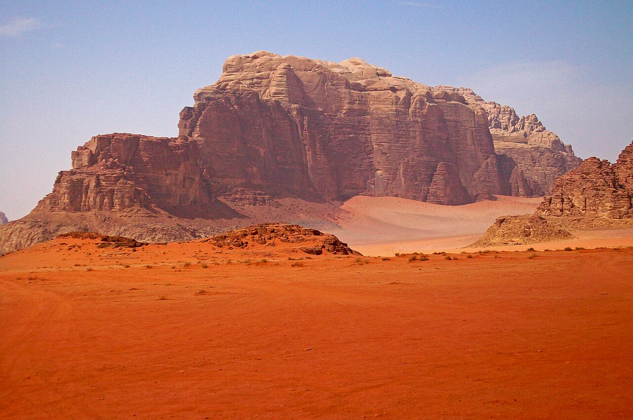
Wadi Rum is a protected area of 74,000 hectares in southern Jordan, 60 km east of Aqaba, formed by red sandstone and granite mountains that rise to 1,754 metres at Jebel Um Adaami — Jordan’s highest point. A UNESCO World Heritage Site since 2011 under the mixed natural and cultural criteria, the area contains approximately 25,000 rock engravings and 4,000 inscriptions documenting 12,000 years of human presence, from prehistoric hunter-gatherers through Nabataean traders and 20th-century military campaigns. The nearest other UNESCO site is Petra, 100 km north via the Desert Highway.
Rock Art, Nabataean Inscriptions and 12,000 Years of Desert Presence Throughout the protected area — accessible by jeep tour from Rum Village
The inscriptions at Wadi Rum span three distinct writing traditions. The oldest are Thamudic inscriptions, carved by nomadic groups from the early Iron Age through the pre-Islamic period — stick-figure hunters and their prey drawn alongside geometric patterns, hands, and early alphabetic script. Nabataean inscriptions follow, recording the names of merchants and travellers passing through the valley on the incense route between Hegra (in modern Saudi Arabia) and Petra. The Nabataeans used Wadi Rum as a staging post on this route; ruins of a small Nabataean temple dedicated to the goddess Allat survive near the village of Rum, along with a spring that provided reliable water in the arid landscape. Arabic inscriptions from the early Islamic period complete the chronological sequence, some overlapping with earlier Nabataean carvings on the same rock faces.
The corpus of approximately 25,000 rock engravings is not evenly distributed across the protected area. Concentrations occur at water sources, along canyon systems, and at the base of the major massifs, particularly Jebel Rum (1,734 m) and Jebel Um Adaami (1,754 m). The site’s UNESCO inscription specifically recognises the Wadi Rum inscriptions as containing the earliest known examples of Nabataean script, predating other Nabataean epigraphic evidence and offering evidence for the development of the alphabet that eventually became modern Arabic. The inscriptions are protected under Jordanian law; visitors on jeep tours pass by several engraved panels along the standard routes, with the most accessible concentration near Khazali Canyon, where a narrow slot canyon contains carvings at eye level on both walls.
The geological formations themselves are part of the UNESCO designation. The inselbergs — isolated mountain masses rising abruptly from the flat desert floor — are composed of Precambrian granite overlaid by Cambrian sandstone that has been sculpted by wind and water into arches, pillars, and canyon systems over millions of years. Burdah Rock Bridge, one of the highest natural arches in the world at 35 metres above the valley floor, is accessible by a guided scramble from the valley. Um Fruth Rock Bridge is smaller and lower, reachable without climbing equipment. The canyon systems, including Lawrence’s Canyon and the Coloured Canyon near Jebel Khash, display cross-sections of the sandstone stratigraphy in bands of red, pink, orange, and white.
T.E. Lawrence, the Arab Revolt and the Valley as Cinematic Landscape Lawrence’s Spring and Lawrence’s House accessible on standard jeep routes from Rum Village
Thomas Edward Lawrence — Lawrence of Arabia — first entered Wadi Rum in 1917 as a British Army officer embedded with Hashemite forces fighting against Ottoman control of the Hejaz Railway. The Arab Revolt of 1916–1918 aimed to disrupt Ottoman supply lines running from Damascus south to Medina; the railway was the primary target. Lawrence coordinated demolition raids along the line, using Wadi Rum as a base from which Bedouin fighters could move rapidly across the desert. His account of the campaign, Seven Pillars of Wisdom (completed 1922, published 1926), contains extended descriptions of the Wadi Rum landscape that became foundational texts in Western writing about the Arabian desert. The most quoted passage describes the mountains as “vast and echoing and God-like” — the phrase directly incorporated into the title of the article you are reading.
Two features in the protected area carry Lawrence’s name, though neither is architecturally significant: Lawrence’s Spring (Ain Lawrence) is a natural water source he described in his account; Lawrence’s House is a rock formation with a small cave that Bedouin guides associated with him in the early tourist period. The historical association is accurate in broad outline — Lawrence did use Wadi Rum as a base — but the specific attributions reflect later tourist naming conventions rather than documented historical fact. A more concrete historical marker is the Hejaz Railway itself, remnants of which survive northeast of the protected area, including a section Lawrence describes demolishing in detail.
The valley’s scale and visual character — raked light on red stone, flat sand floors between vertical cliffs, absolute silence broken by wind — made it a preferred substitute for Mars in Hollywood productions. The Martian (Ridley Scott, 2015) used Wadi Rum to represent the Martian surface; scenes were filmed partly on location and partly on sets built to match the landscape. Star Wars: The Rise of Skywalker (2019) used it for the desert planet Pasaana. Dune (Denis Villeneuve, 2021) filmed in Wadi Rum for sequences representing the planet Arrakis. The earlier David Lean film Lawrence of Arabia (1962), starring Peter O’Toole, was the first major production to film substantially in the valley; it established the visual grammar that subsequent filmmakers have drawn on. The Bedouin tribes of the valley — the Zalabia and Zawaideh — have operated the tourist economy since the 1980s; jeep tours, camel treks, and overnight camps in the protected area are their primary livelihood.
Practical information
Wadi Rum Village is the entry point; the visitor centre at the village edge sells tickets and organises licensed jeep tours. The protected area is not accessible by private vehicle without a guide — this is a condition of the UNESCO management plan. Standard half-day and full-day jeep tours cover the main rock engravings, natural arches, and Lawrence-associated sites. Overnight camps, operated by Bedouin families inside the protected area, range from basic Bedouin tents to the pressurised bubble domes marketed in tourism photography; these require advance booking. The nearest city is Aqaba (60 km west), which has an international airport with direct connections to Amman and European cities. Buses run between Aqaba and Wadi Rum Village. From Petra (100 km north), most visitors travel via private taxi or tourist shuttle; the journey takes approximately 1.5 hours on the Desert Highway. Entry fees to the protected area are set by the Jordan Tourism Board. The best visiting months are March to May and September to November; summer temperatures exceed 40°C in the valley, and winter nights can drop below freezing. The Jordanian Jordan Pass, which covers entry to Petra and Wadi Rum among other sites, is available online and significantly reduces combined costs for multi-site visitors.
Frequently Asked Questions
What are the Thamudic and Nabataean inscriptions at Wadi Rum, and why are they significant?
Thamudic is a collective term for a group of ancient North Arabian scripts used by pastoral and nomadic communities across the Arabian Peninsula from roughly the 6th century BCE through the 4th century CE. The Thamudic inscriptions at Wadi Rum are largely informal — travellers recording their names, hunters depicting their prey, and makers of geometric patterns for purposes that remain debated. They are scratched into rock surfaces rather than formally carved, and the script runs in multiple directions without consistent convention, suggesting production by many different hands over a long period rather than by trained scribes. The Nabataean inscriptions are formally different: the Nabataean script is more standardised, closer in form to early Aramaic, and its presence at Wadi Rum documents the valley’s role in the commercial network centred on Petra. The specific significance of the Wadi Rum Nabataean inscriptions for UNESCO lies in their date: they have been assessed as containing some of the earliest attested examples of Nabataean writing, offering evidence for the emergence of the script in the 4th or 3rd century BCE. This is relevant to the history of the Arabic alphabet, since the Nabataean script is one of the direct ancestors of modern Arabic writing — the letter forms evolved from Nabataean through early Arabic script between the 4th and 7th centuries CE.
How did the Bedouin tribes of Wadi Rum relate to T.E. Lawrence during the Arab Revolt?
Lawrence worked primarily with the Howeitat tribe under the leadership of Auda abu Tayi, whose territory covered the area east and north of Wadi Rum toward the Hejaz. The Zalabia and Zawaideh tribes, based in the valley itself, were part of the broader coalition of Hashemite-allied forces. Lawrence describes meeting tribal leaders and negotiating their participation in raids in Seven Pillars of Wisdom; his account presents the relationships as a combination of material incentive (British gold payments for participation), personal negotiation, and genuine political conviction among some tribal leaders that Ottoman rule was preferable to displace. The question of how accurately Lawrence represented these relationships has been debated by historians since the 1960s; Suleiman Mousa’s 1966 study T.E. Lawrence: An Arab View, drawing on Arab sources, challenged several of Lawrence’s claims about his own role and the motivations of his Bedouin allies. What is not in dispute is that the Arab Revolt succeeded in disrupting the Hejaz Railway and that the Bedouin fighters who participated demonstrated a logistical capability — rapid movement across desert terrain, knowledge of water sources, and capacity for hit-and-run demolition — that conventional military planning had not anticipated. The Wadi Rum area functioned as a mustering point and resupply base for these operations.
What is the difference between visiting Wadi Rum on a day trip versus staying overnight in the protected area?
A day visit — either a half-day or full-day jeep tour from the village — covers the principal sites: the main rock art panels at Khazali Canyon, the Nabataean spring and temple ruins, the smaller natural arches, and the sand dunes near the base of Jebel Rum. The landscape in full daylight gives a clear understanding of the scale and geological character of the valley, and most visitors find a single full day sufficient to see the UNESCO-listed features. An overnight stay inside the protected area adds two specific things that a day visit cannot provide: sunset and sunrise light on the sandstone, when the stone turns from orange to deep red and the long shadows reveal the surface texture of the cliff faces in ways that midday light flattens; and a night sky of exceptional clarity, with minimal light pollution and the full Milky Way visible from within the valley on clear nights. The camps range widely in character from basic Bedouin-operated tents with simple food to commercially developed glamping sites with pressurised bubble domes that have become prominent in social media. The quality and atmosphere of the experience depends substantially on which operator is chosen; the Jordan Tourism Board maintains a register of licensed camp operators, and independent reviews on booking platforms give a more accurate sense of current standards than promotional materials.
Sources
- S1 — Department of Antiquities of Jordan (DOA) — Wadi Rum Protected Area & Rock Art Heritage — http://doa.gov.jo/
- S2 — Geraldine Chatelard — The Bedouin of Wadi Rum: Culture and Conservation in Jordan, UNESCO Publishing, Paris, 2005, ISBN 978-9231039867
Spotted an error? Write to editorial@culturalheritageonline.com and we correct it the same day.