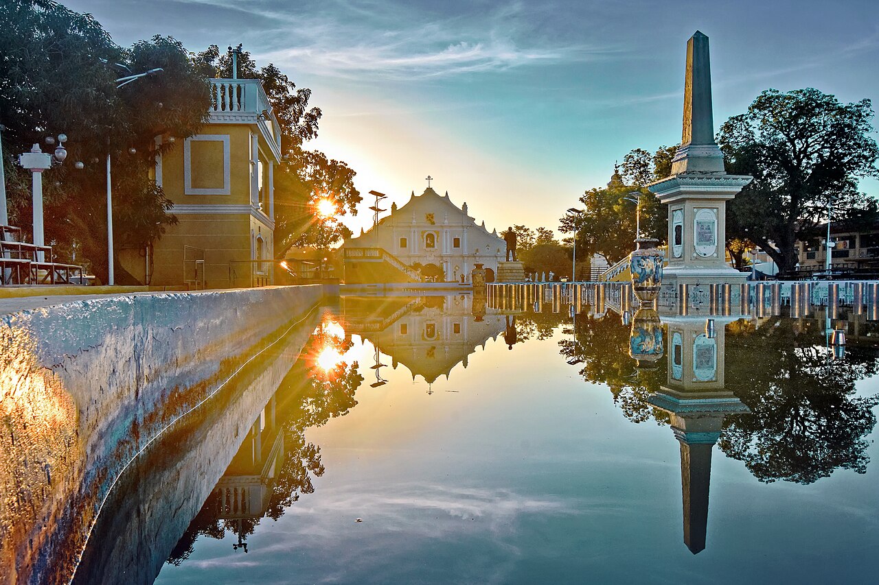
The Historic City of Vigan in Ilocos Sur Province on the northwest coast of Luzon, Philippines, is the only pre-20th-century Spanish colonial city in the Philippines to survive substantially intact; UNESCO inscribed it in 1999 under criteria (ii) and (iv), recognising it as an exceptional example of the planned Spanish colonial town in Asia, where a 16th-century grid of 190 heritage structures — combining Chinese, Spanish, and indigenous Ilocano architectural elements — has remained continuously inhabited. Four other UNESCO World Heritage Sites are distributed across the Philippine archipelago within 700 kilometres: the Baroque Churches of the Philippines (shared listing with Vigan’s Cathedral from 1993), the Rice Terraces of the Philippine Cordilleras (1995), Puerto Princesa Subterranean River (1999), and Tubbataha Reefs Natural Park (1993).
Vigan’s colonial grid and the Baroque Churches of the Philippines shared heritage Vigan is 408 km north of Manila by road — 6–7 hours by bus via the North Luzon Expressway; the nearest Baroque Church sites are Paoay (25 km north) and Santa Maria (50 km south)
Vigan was founded in 1572 by Juan de Salcedo, a Spanish soldier and grandson of the conquistador Miguel López de Legazpi, who had established the first permanent Spanish settlement in the Philippines at Cebu in 1565. The town was laid out following the Laws of the Indies, the regulatory framework governing Spanish colonial urban planning in the Americas and Asia, which prescribed a central plaza flanked by a church, government building, and market — a configuration still recognisable in Vigan today. The central Plaza Salcedo retains this arrangement; the Cathedral of Saint Paul occupies the north side, the Ilocos Sur Provincial Capitol the west, and a landscaped public square the centre.
The architectural character that distinguishes Vigan from other Philippine colonial towns — and that the UNESCO inscription specifically identifies — is the three-way synthesis of building traditions. Chinese merchant settlers, who arrived in significant numbers following Spanish establishment of the Manila Galleon trade, contributed ground-floor layout principles and the use of Chinese-fired red tiles; Spanish colonial builders provided the regulatory street grid, the stone construction of major civic and ecclesiastical structures, and the use of carved wooden decorative elements in upper-story windows; indigenous Ilocano craftsmen integrated local hardwoods, particularly molave (Vitex parviflora), into stair balustrades, floor planks, and the overhanging upper stories (called the zaguan on ground level and the camarin at the back). The fusion produces what architectural historians call the Ilocano house type, characterised by a stone lower floor and a wooden cantilevered upper floor with jalousie windows made of capiz shell (windowpane oyster, Placuna placenta).
Calle Crisologo, the primary heritage street, is a narrow cobblestoned lane approximately 500 metres long running north from Plaza Burgos through the most concentrated zone of merchant houses. The cobblestones are irregular river boulders — not dressed stone — embedded in a compacted earthen base; vehicles are restricted during daytime hours and the street is primarily traversed by kalesa (horse-drawn carriages), a transport form that remains operational as both practical transport and a tourist amenity. The 190 heritage structures within the Vigan core zone are monitored by the Vigan Conservation Council; a smaller number are officially registered as National Cultural Treasures by the National Museum of the Philippines.
The Cathedral of Saint Paul (formally the Parochial Church of Saint Paul the Apostle) was first constructed in 1641 on the foundations of an earlier wooden church. Earthquakes destroyed and damaged successive constructions; the current facade dates primarily to the 18th and 19th centuries and reflects the Baroque-Earthquake style developed by Spanish colonial builders across the Philippines, characterised by massively thick walls, wide buttresses, and low bell towers designed to resist seismic damage. The Baroque Churches of the Philippines UNESCO listing, inscribed separately in 1993 under criteria (ii) and (iv), designates four churches as a single transnational serial property: San Agustín Church in Manila (completed 1607, the oldest stone building in the Philippines), San Agustín Church in Paoay in Ilocos Norte (completed 1710), Nuestra Señora de la Asunción in Santa Maria in Ilocos Sur (completed 1769), and the Immaculate Conception Church in Miag-ao in Iloilo (completed 1797). Vigan Cathedral is not formally part of this 1993 listing but sits within the 1999 Vigan city inscription; Paoay is 25 kilometres north of Vigan and Santa Maria 50 kilometres south, making them both accessible as day trips.
Vigan’s survival through three periods of foreign administration — Spanish (1572–1898), American (1898–1946), and Japanese occupation (1941–1945) — each of which altered the urban fabric of other Philippine cities, is the product of several contingent factors. During the Second World War, Japanese forces used Vigan as a regional administrative headquarters, which reduced the incentive to bomb or destroy it; American forces likewise refrained from large-scale air strikes on the town. Post-independence development pressure, which demolished much of colonial Manila (Intramuros) and transformed other provincial towns, was partially deflected by Vigan’s relative economic marginality and its distance from the industrial development corridors of central Luzon.
The Rice Terraces of the Cordilleras, Puerto Princesa’s underground river, and the coral of Tubbataha Rice Terraces 200 km east via Mountain Province; Puerto Princesa 300 km south on Palawan island (1-hour flight); Tubbataha 600 km south (liveaboard from Puerto Princesa)
The Rice Terraces of the Philippine Cordilleras, inscribed in 1995 under criteria (iii), (iv), and (v), are a cluster of five terrace systems in the Cordillera Central mountain range of northern Luzon, with the most extensive and visited group at Banaue in Ifugao Province, approximately 200 kilometres east of Vigan by road (6–8 hours via the mountain road through Bontoc). The Ifugao people have maintained wet-rice agriculture on these carved hillside terraces for an estimated 2,000 years, though the precise dating of the earliest construction is debated; some Philippine government materials cite figures as high as 2,000 years, while archaeological work has not conclusively established whether all visible terrace systems date that far back. The total area of active terrace cultivation in the Cordillera region exceeds 10,000 square kilometres. The terrace walls, built from stone and compacted earth without mortar, reach up to 5 metres in height in the steepest sections; the system incorporates an elaborate traditional irrigation network drawing from cloud forest above the terraces.
The UNESCO listing covers five clusters: Nagacadan, Kiangan, Hungduan, Bangaan, and Batad, of which Batad is the most photographed due to its amphitheatre configuration and the absence of road access (a 45-minute walk from the road end is required). The site was placed on UNESCO’s List of World Heritage in Danger in 2001 due to concerns about terrace abandonment as young Ifugao moved to urban employment, and partially removed from the danger list in 2012 following documented conservation improvements; ongoing maintenance of the irrigation system is the primary sustainability challenge, as the terraces require continuous management of water channels to prevent collapse.
Puerto Princesa Subterranean River National Park on Palawan Island, inscribed in 1999 under criteria (vii) and (x), contains an 8.2-kilometre navigable underground river system — the longest navigable underground river that empties directly into the sea. The river flows through a cave passage of the Saint Paul Mountain Range and exits into the South China Sea at Puerto Princesa Bay; the tidal influence of the sea extends several kilometres into the cave, creating a brackish zone at the entrance. The cave system contains large chambers with significant stalactite and stalagmite formations; a colony of millions of swiftlets (primarily Collocalia fuciphaga) roosts in the cave and their nests — used in bird’s nest soup — have been harvested by licensed collectors under traditional right. The site was designated one of the New Seven Wonders of Nature in a global internet vote in 2012. Access is by boat from Sabang village, 77 kilometres northwest of Puerto Princesa City; visitor numbers are capped per day and advance permit booking through the Puerto Princesa City Environment and Natural Resources Office is required.
Tubbataha Reefs Natural Park, in the Sulu Sea approximately 150 kilometres southeast of Puerto Princesa (and 600 kilometres from Vigan), was inscribed in 1993 and expanded in 2009 to cover 97,030 hectares of open-ocean coral reef ecosystem with no permanent human settlement. The park consists of two reef atolls — North and South Tubbataha — and Jessie Beazley Reef, rising from the deep Sulu Sea floor. The reef system supports 360 species of coral (including all 13 coral genera occurring in the Philippines), 479 fish species, 11 shark species, 2 marine turtle species, and a significant seabird nesting population. The remoteness of the site from any coast — the nearest inhabited island is 150 kilometres away — has protected it from the overfishing and blast-fishing that have degraded coastal reefs elsewhere in Southeast Asia. Access is exclusively by liveaboard dive vessel; the Philippine government limits the annual visiting season to March through June, when the northeast monsoon provides calm sea conditions, and issues a controlled number of permits per year. Dive depth ranges from 3 to over 40 metres; the walls of both atolls drop vertically to depths beyond sport diving range.
Practical information
Vigan is best reached by overnight bus from Manila (8 hours northward along the North Luzon Expressway), with multiple operators departing from the Pasay bus terminal district; the journey is shorter in the reverse direction (Manila to Vigan) when travelling north. Alternatively, domestic flights connect Manila to Laoag (72 kilometres north of Vigan) or San Fernando, La Union (131 kilometres south); both require onward bus or van transfer. The best season for Ilocos Norte and Sur is the dry season from November through April, when the northeast monsoon brings cooler temperatures of 22–30°C and low rainfall; the June–October typhoon season can bring significant wind and rain to the Ilocos coast, which faces the South China Sea. The Filipino peso (PHP) is the currency throughout the Philippines; ATMs are available in Vigan city centre.
For the Cordillera rice terraces, a Vigan base permits a long day trip to Banaue (200 km east, though road time is 6–8 hours in each direction); more practical is a 2-night stop in Banaue or the smaller guesthouses at Batad. For Puerto Princesa Subterranean River, a separate flight from Manila or Cebu to Puerto Princesa City is the standard routing; travel from Vigan to Puerto Princesa requires transiting Manila (1 hour by road from Vigan airport at Laoag, then domestic flight 1.5 hours). Tubbataha can only be visited as a liveaboard trip from Puerto Princesa, requiring advance booking with one of approximately 25 permitted liveaboard vessels; the season is strictly March through June. Philippine immigration provides 30 days’ visa-free entry for most Western nationalities; extensions are available from the Bureau of Immigration in Manila.
Frequently Asked Questions
What makes Vigan architecturally different from other Spanish colonial cities in Asia, and why did it survive intact?
Vigan’s architectural distinctiveness rests on the specific synthesis of three building traditions that converged in a relatively small trading town over the 16th through 19th centuries. Spanish colonial urban planning provided the regulatory framework: the Laws of the Indies prescribed a central plaza, a church on one side, civic buildings on the others, and a grid of rectilinear streets extending outward. Chinese merchant settlers — the Sangleys, as Spanish records called them, who worked as artisans, traders, and craftsmen in close proximity to the port — contributed their knowledge of ceramic roof tile production (using locally sourced clay and the high-temperature firing techniques brought from Fujian Province), the spatial organisation of the shophouse ground floor, and certain decorative stonework patterns. Indigenous Ilocano craftsmen, who supplied the skilled construction labour, integrated local hardwoods — particularly the dense, decay-resistant molave — into every element that required flexibility or spanning: stair balustrades, floor planks, the projecting upper-floor cantilever, and the capiz-shell jalousie windows that filter light and sea breezes without glass. The result is a building type found nowhere else in Southeast Asia. As for survival: Vigan’s relative economic marginality in the post-independence period meant that real estate pressure for modernisation was lower than in Manila, Cebu, or Davao; the Japanese occupiers who used it as an administrative headquarters had an incentive to preserve the existing building stock; and the American liberation campaign in 1945 targeted Luzon’s central plain and Manila rather than the northwest Ilocos coast. The conservation legislation enacted from the 1970s onward under the National Historical Commission formalised protection of the core zone, though demolition of peripheral structures has continued outside the buffer area.
How old are the Rice Terraces of the Philippine Cordilleras, and are they still being farmed?
The Ifugao rice terraces are conventionally described as 2,000 years old in both tourism and Philippine government materials, but the archaeological basis for this figure deserves qualification. The most accurate current scientific assessment, based on radiocarbon dating of organic matter from terrace fill layers and from cultural middens associated with the terrace-building settlements, supports an initial construction period beginning roughly 1,000 to 2,000 years ago, with different terrace clusters having different founding dates. The terraces are not a single construction project but a gradual expansion of wet-rice cultivation into progressively higher elevations by the Ifugao people over many generations. The oldest definitively dated terrace systems cluster around 1,000 years before the present; some researchers argue for origins closer to 2,000 years, but the evidence remains contested. What is not contested is that the terraces represent a sophisticated integrated landscape: the terrace walls retain soil moisture, the ponded fields (paddy) control water through an elaborate gravity-fed irrigation network drawing from cloud forest at the mountain summit, and the biological diversity of the water channels — which contain fish, edible snails, and frogs — supports the nutritional base of the terrace communities. Active farming continues, though the adult farming population has declined as younger Ifugao seek urban employment; the municipality of Banaue and NGO organisations working with the Ifugao Terraces Commission have implemented programmes to support traditional cultivation as both a heritage and a food-security practice. UNESCO’s partial removal of the site from its World Heritage in Danger list in 2012 reflects genuine improvements in terrace maintenance, though the site remains in a monitored state.
When is the best time to visit Tubbataha Reefs, and what level of diving experience is required?
Tubbataha Reefs Natural Park is accessible only during the northeast monsoon season, from approximately March 1 through June 15 each year, when calm sea conditions in the Sulu Sea make the 150-kilometre open-water crossing from Puerto Princesa safe for liveaboard vessels. Outside this window — from June through February — the southwest monsoon and typhoon season creates seas that make the passage dangerous and the site effectively unreachable. The Philippine government enforces these dates and limits the number of permitted vessel entries per season; all visitors must enter on a licensed liveaboard dive vessel, and there is no accommodation on either Tubbataha atoll itself. The Philippine Tourism Authority (through the Tubbataha Management Office) issues entry permits and controls vessel numbers. In terms of diving experience, Tubbataha is not a beginner destination. The site is characterised by strong and unpredictable currents — particularly at the reef walls and at cleaning stations — and visibility, while often exceeding 30 metres, can drop at thermocline layers. The minimum recommended certification is PADI Open Water, but most liveaboard operators and dive guides recommend Advanced Open Water experience as a practical baseline, with deep diving and drift diving specialties recommended for the more demanding sites. The walls of both North and South Tubbataha drop vertically to beyond 40 metres, and the most significant pelagic encounters — including whale sharks, hammerhead sharks, and thresher sharks — occur at depth or in blue water. Booking a Tubbataha liveaboard requires advance reservation of at least 3–6 months for peak-season departures, and costs typically range from $2,500 to $4,500 USD per person for a 7-night trip including all dives and meals.