
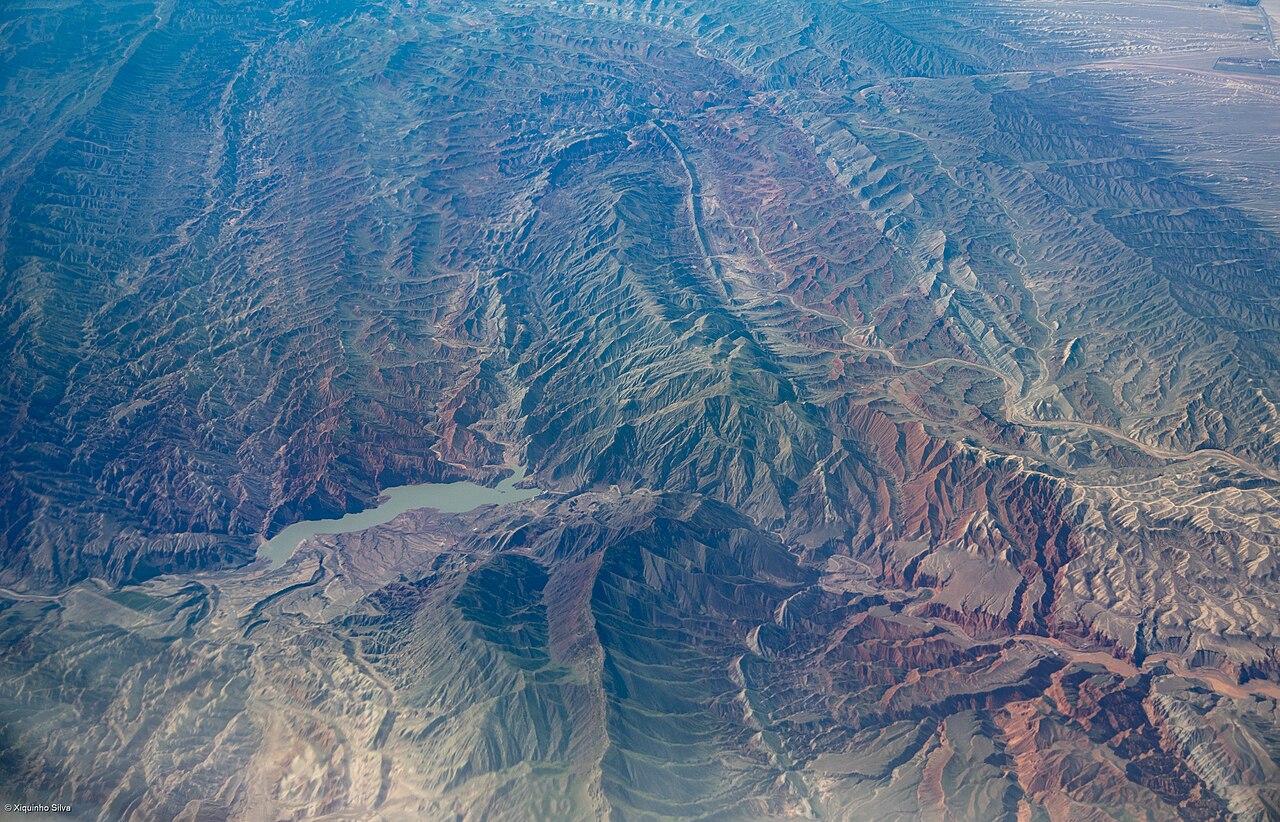
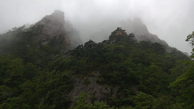
Xinjiang Tianshan (UNESCO 2013) is a natural World Heritage property covering 606,833 hectares across four non-contiguous clusters in China’s Xinjiang Uyghur Autonomous Region: Tomur (the highest cluster, with the Tomur/Tuomuer peak at 7,439 metres), Bayanbulak (alpine meadow and internationally important wetland for whooper swan at 2,400–2,600 metres elevation), Kalajun-Kuerdening (mixed forest and glaciated valley), and Bogda (including the glacial Tianchi Lake at 1,928 metres). The Tianshan range extends approximately 2,500 kilometres from the Pamir Plateau in the west to the Gobi Desert margin in the east, crossing six countries; the glaciers of the Xinjiang section feed river systems that provide water to an estimated 800 million people in Central Asia and northwestern China. The nearest major city, Urumqi, is approximately 200 kilometres by road from the Bogda cluster and reachable by air or HSR from Beijing (3h flight, or 13h HSR) and Xi’an (3h flight).
East and south: Silk Roads Chang’an-Tianshan Corridor and Mogao Caves Silk Road sites within Xinjiang at Turpan 190 km from Urumqi; Mogao Caves 1,000 km east at Dunhuang, 10h road or 1.5h air
The Silk Roads: the Routes Network of Chang’an-Tianshan Corridor, inscribed as UNESCO World Heritage in 2014, is the most directly connected cultural property to the Xinjiang Tianshan natural site. The physical relationship between the two UNESCO inscriptions is one of cause and effect: the Tianshan mountains are why the Silk Road routes took the form they did. The range’s western peaks, rising above 7,000 metres with no road passes in the ancient period, forced eastward travellers from Central Asia to choose between the northern route (crossing the Ili Valley north of the mountains, then descending through Jungar Gate to the Dzungarian Basin and skirting north of the Tianshan to Turpan and Dunhuang) and the southern route (following the Fergana Valley south of the range, crossing through the Tian Shan passes at lower elevation around Kashgar, then skirting the southern edge of the Tarim Basin through Khotan and Miran to Dunhuang). The Silk Road inscription’s component sites in Kazakhstan and Kyrgyzstan — Suyab, Balasagun and the Burana Tower site in the Chu Valley, the Aktobe and Koilyik sites in the Ili Valley — are positioned precisely in the river valleys and oasis towns where the northern Silk Road routes descended from the Tianshan foothills. Within the Xinjiang section of the inscription, the most significant component sites include Jiaohe Ruins and Gaochang Ruins near Turpan (the “Flaming Mountains” basin 190 kilometres southeast of Urumqi, reachable in 2.5 hours by road or 30 minutes by high-speed rail from Urumqi). Jiaohe is a cliff-top city built on an island formed by two converging ravines; it functioned as the Jushi Kingdom capital from approximately 200 BCE and was occupied through the Yuan dynasty (13th century CE), after which it was abandoned. The ruins cover 430,000 square metres and are among the best-preserved ancient earthen cities in Asia, with street plans, building foundations, Buddhist stupa remains and the stumps of poplar trees that once lined the main avenue still visible. Gaochang Ruins, 47 kilometres east of Turpan, were the capital of the Gaochang Kingdom (6th–7th century CE) and then a Uyghur capital (9th–13th century CE); the monk Xuanzang stopped here in 630 CE during his journey from Chang’an to India and spent a month at the court of King Qu Wentai before continuing west through the Tianshan passes. The Kizil Grottoes, 75 kilometres west of Kuqa (5h from Urumqi by road), are the earliest Buddhist cave complex in China (3rd–9th century CE), predating Mogao Caves by approximately a century; their strongly Central Asian artistic style — notably the “diamond shape” ceiling compositions and the non-Chinese figural proportions — documents the westward artistic influences arriving with Buddhism.
The Mogao Caves near Dunhuang in Gansu Province, inscribed as UNESCO World Heritage in 1987, are approximately 1,000 kilometres east of Urumqi by road across the Hexi Corridor; the most practical connection is by air from Urumqi to Dunhuang (1.5 hours, several weekly flights) rather than by road (approximately 10 hours on the G30 expressway). Dunhuang was the last significant oasis before the desert crossing for travellers on the Silk Road’s northern and southern routes, positioned where the two route variants rejoined before the Hexi Corridor. The Mogao cave complex contains 492 decorated caves with a total wall-painting area of approximately 45,000 square metres; the artistic program spans from the late 4th century CE to the 14th century and documents 1,000 years of continuous Buddhist patronage from merchants, pilgrims and officials preparing for or returning from the Silk Road desert crossing. The connections between Mogao and the Xinjiang Tianshan are ecological as well as historical: the Gobi and Taklamakan deserts that separate Dunhuang from Turpan and the Tianshan exist because the mountains capture precipitation on their northern slopes, creating rain shadow conditions to the south and east. The Tianshan glaciers that feed the Tarim River and its tributaries (Aksu, Yarkand, Hotan rivers) once supported a string of oasis settlements around the Tarim Basin rim — Kashgar, Yarkand, Khotan, Miran, Dunhuang — that formed the physical infrastructure of the southern Silk Road. A combined Xinjiang and Dunhuang itinerary (Urumqi → Tianchi Lake → Turpan Silk Road ruins → Dunhuang Mogao Caves) captures both the mountain geography and the desert-oasis archaeology that together explain the Silk Road’s route logic.
South and southwest: Qinghai Hoh Xil and Three Parallel Rivers of Yunnan Qinghai Hoh Xil 1,500 km south, via Golmud; Three Parallel Rivers of Yunnan 2,500 km south via Lijiang or Deqin
The Qinghai Hoh Xil UNESCO Natural World Heritage site, inscribed in 2017, covers 4,503,571 hectares on the Qinghai-Tibetan Plateau, approximately 1,500 kilometres south of Urumqi. The direct surface connection is via the Qinghai-Tibet Highway (National Highway G109) from Golmud to the Hoh Xil boundary; the more practical access route is by train on the Qinghai-Tibet Railway from Xining (reachable from Xi’an by HSR in 3h) to Golmud, or flying to Golmud from Urumqi (1.5h). Hoh Xil is a high-altitude uninhabited wilderness at elevations of 4,500 to 6,860 metres, covering one of the largest areas of permafrost on earth outside of polar regions; its UNESCO significance is primarily as the calving ground and habitat of the Tibetan antelope (chiru, Pantholops hodgsonii), whose population declined from an estimated 1 million individuals in the early 20th century to approximately 70,000 by the mid-1990s due to poaching for the shahtoosh wool trade. Protection efforts since the 1990s have brought the population back to approximately 300,000. The biogeographic connection between Xinjiang Tianshan and Qinghai Hoh Xil is the Central Asian plateau uplift system: both properties lie on or adjacent to the Tibetan Plateau, which was formed by the same tectonic collision between the Indian subcontinent and Eurasian plate (beginning approximately 50 million years ago) that created the Tianshan, Pamir, Kunlun and Himalaya ranges as a connected series of east-west fold mountain belts. The Tianshan glaciers and the Hoh Xil plateau permafrost are both expressions of the same high-elevation cold-desert climate zone that extends across Central Asia at altitudes above 4,000 metres. Wildlife ecologically comparable between the two properties includes the snow leopard (present in both Tianshan and the Hoh Xil buffer zone), brown bear, argali wild sheep and wolf. Hoh Xil is not accessible to independent tourists; visits to the buffer zone require a permit from the Hoh Xil Nature Reserve Administration in Golmud, and the core zone is closed entirely.
The Three Parallel Rivers of Yunnan Protected Areas, inscribed as UNESCO World Heritage in 2003, covers 1,700,000 hectares in northwestern Yunnan Province, approximately 2,500 kilometres south of Urumqi; the nearest access point is Lijiang (flights from Urumqi 3h, or overnight train from Chengdu 10h), from which the Deqin area at the southern edge of the protected area is approximately 7 hours by road. The property covers the gorges and mountain ecosystems where the Jinsha River (upper Yangtze), Lancang River (upper Mekong) and Nu River (upper Salween) run parallel for approximately 170 kilometres through a north-south oriented zone of mountain ridges reaching 6,740 metres at Kawagebo Peak. The connection between the Three Parallel Rivers and Xinjiang Tianshan is tectonic and biogeographic. Both properties are located on segments of the same Tethyan orogenic system — the chain of mountain ranges formed by the closure of the ancient Tethys Ocean as the Indian subcontinent drove northward into Eurasia. The Tianshan represents the northern segment of this uplift; the Pamirs connect it to the southern segment; and the Hengduan Mountains of the Three Parallel Rivers represent the eastern flank where the Tibetan Plateau meets the Yunnan lowlands. The biodiversity consequence of this mountain chain is extraordinary: the Hengduan Mountains are a global biodiversity hotspot with over 6,000 plant species and approximately 30 percent of all China’s animal species; the Xinjiang Tianshan contains approximately 2,700 plant species, including 11 endemic to the property. Karst towers visible in the Three Parallel Rivers area and the granitic and schist cliffs of the Tianshan represent different lithologies from the same tectonic story, offering a geologically varied companion to the Xinjiang mountain scenery for travellers covering multiple Chinese UNESCO natural properties.
Practical information
Urumqi is the gateway city for all four Xinjiang Tianshan clusters. The Bogda cluster and Tianchi Lake are the most accessible: regular buses depart from Urumqi South Bus Station from May through October, with a journey of approximately 1.5 hours to the lake; a cable car covers the final elevation gain from the lake shore to the higher viewpoints. The Bayanbulak cluster (alpine meadows and crane wetland) is in Hejing County, 380 kilometres southwest of Urumqi by road (5h); it is worth the journey in late May–June for whooper swan nesting or July for peak wildflower, but there is no direct public transport. The Kalajun-Kuerdening cluster is in Tekes County near Nalati grasslands, reachable by road (4h from Urumqi). The Tomur cluster requires an expedition approach from Aksu (4h from Urumqi by road); no public transport reaches the core area, and mountaineering permits are required for the high peaks. Summer (June to August) is the operational season for all four clusters. The Turpan Silk Road sites are best visited in April to May or September to October — Turpan is one of the hottest places in China (recorded maximum 49.6°C in summer). Urumqi has a major airport with direct international connections to Central Asian cities (Almaty, Bishkek, Tashkent) as well as domestic connections to all major Chinese cities. Travellers should budget additional time at all checkpoints in Xinjiang.
Frequently Asked Questions
What are the four clusters of Xinjiang Tianshan and what makes each distinct?
The Xinjiang Tianshan UNESCO inscription is structured as a serial natural property with four geographically separate clusters, each representing a different ecological and geomorphological expression of the Tianshan mountain system. The Tomur cluster, in Aksu Prefecture near the Kyrgyzstan border, contains the highest peaks of the Chinese Tianshan, including Tomur (Tuomuer) at 7,439 metres, the highest point in the range, and Hantengri at 6,995 metres. The cluster is characterised by glacier coverage (approximately 3,700 square kilometres of glacier within and adjacent to the property), alpine tundra, and the steep-sided river gorges carved by glacial meltwater. Access is limited to permitted mountaineering expeditions; there is no visitor infrastructure in the core zone. The Bayanbulak cluster, in Hejing County of Bayingolin Mongolian Autonomous Prefecture, is an enclosed alpine basin at 2,400–2,600 metres surrounded by Tianshan ridges rising to 4,000 metres. The basin floor is a mosaic of alpine meadow, wetland and braided river channels; it is the most important breeding ground for the whooper swan (Cygnus cygnus) in China, with a peak breeding population of approximately 700 pairs, and also supports breeding populations of black-necked crane, bar-headed goose and grey heron. A viewing platform at the Swan Lake observation area is accessible by road from Bayanbulak town. The Kalajun-Kuerdening cluster, in the Ili Kazakh Autonomous Prefecture, is a valley and ridge landscape at elevations of 1,500–4,500 metres, distinguished by the altitudinal vegetation sequence: valley-floor grassland gives way to mixed forest (Schrenk spruce, Tian Shan birch and rowan), then subalpine meadow, then alpine tundra and permanent snowfield. The cluster contains the Kalajun and Kuerdening scenic areas, both with established visitor infrastructure and summer yurt camps operated by Kazakh herding families. The Bogda cluster, closest to Urumqi, centres on the Bogda Peak (Bogda Feng) at 5,445 metres and the glacial Tianchi (Heavenly Lake) at 1,928 metres elevation. Tianchi is 3.4 kilometres long and 1.5 kilometres wide, fed by the Bogda glacier system; it sits within a cirque of conifer forest (Schrenk spruce) with the snow-capped peak visible directly above the lake on clear days.
How do the Tianshan glaciers feed river systems, and why are they important for Central Asia?
The Tianshan mountains intercept moisture-bearing air masses moving from the Atlantic and Arctic Oceans across the Eurasian interior; at elevations above approximately 3,500 metres, precipitation falls as snow year-round, accumulating in glacial systems. The Xinjiang Tianshan contains approximately 9,081 glaciers with a total area of approximately 9,225 square kilometres (as of early 21st century measurements), representing the largest concentration of mid-latitude glaciers in the world after the polar ice sheets. These glaciers feed river systems that are the primary freshwater source for a belt of territory extending from Xinjiang into Kazakhstan, Kyrgyzstan and Uzbekistan: the Amu Darya’s tributaries (Vakhsh, Panj) originate partly in the western Tianshan; the Syr Darya originates in the Ferghana Valley south of the Tian Shan; the Tarim River and its tributaries (Aksu, Yarkand, Hotan) drain the southern Tianshan slopes into the Tarim Basin, the endorheic (internally draining) basin that contains the Taklamakan Desert. Agricultural civilisations in the Ferghana Valley, the Ili Valley, the Chu Valley and the Tarim Basin oases have depended on Tianshan meltwater for irrigation since at least 1500 BCE. UNESCO’s Outstanding Universal Value justification for the 2013 inscription specifically identifies the role of the Tianshan glaciers as a freshwater reserve for approximately 800 million people in downstream areas of Central Asia and northwestern China. Current glaciological monitoring data indicate that most Xinjiang Tianshan glaciers are losing mass: the Urumqi Glacier No. 1, on the northern slope of the Tianshan approximately 130 kilometres south of Urumqi (accessible to research visitors at a monitoring station), has lost approximately 22 percent of its length since 1959 and has retreated 400 metres; it is one of the most intensively monitored glaciers in Asia. The rate of loss has accelerated since the 1990s; the monitoring station operates a visitor access programme from June to September.
What is the Silk Road relationship between the Tianshan and the oasis cities of Xinjiang?
The Silk Road oasis cities of the Tarim Basin — Kashgar, Yarkand, Khotan, Niya, Miran, Dunhuang — existed because the Tianshan glaciers delivered meltwater to an otherwise waterless desert basin. The Taklamakan Desert at the centre of the Tarim Basin receives less than 10 millimetres of precipitation annually; without the rivers draining from the Tianshan and Kunlun ranges, it could not support any permanent human settlement. The oasis towns formed where major meltwater rivers approached the basin rim and provided sufficient water for agriculture and animal husbandry; Khotan (Hetian), for example, sits where the Hotan River — fed by Kunlun glaciers to the south and Tianshan meltwater mixing through the basin aquifer to the north — creates a ribbon of cultivable land through the desert. The Silk Road routes skirted the Taklamakan on the north (along the Tianshan foothills through Turpan, Kuqa and Kashgar) or on the south (through the Kunlun foothills through Miran, Niya and Khotan), both routes converging at Kashgar before crossing the Pamirs westward or the Karakoram southward into South Asia. Turpan’s agricultural system is directly dependent on the Tianshan: the karez (qanat) underground irrigation channels that water the Turpan oasis draw on the Tianshan aquifer recharged by glacial meltwater; the Turpan karez system contains approximately 1,100 individual channels totalling 5,000 kilometres, dug by hand to depths of up to 80 metres, and has sustained intensive grape, melon and cotton cultivation in an environment where surface temperatures exceed 45°C. The oasis cities’ survival therefore depended on the Tianshan glacier systems in a direct hydraulic relationship that persisted for 2,000 years of Silk Road operation — making the Xinjiang Tianshan UNESCO natural property and the Silk Roads cultural property inseparable aspects of the same geographic and historical phenomenon.
Sources
- S1 — UNESCO World Heritage Centre — Xinjiang Tianshan (Ref. 1414) — https://web.archive.org/web/20230601000000/https://whc.unesco.org/en/list/1414/
- S2 — Xinjiang Forestry and Grassland Bureau — https://whc.unesco.org/en/list/1414/
- S3 — Seidensticker, John. <em>Riding the Tiger: Tiger Conservation in Human-Dominated Landscapes</em>. Cambridge University Press, 1999. ISBN: 978-0-521-64835-6.
Spotted an error? Write to editorial@culturalheritageonline.com and we correct it the same day.
.jpg)