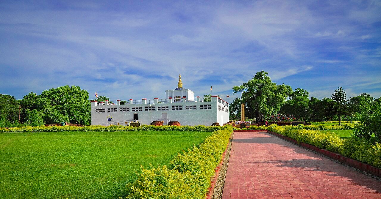
Lumbini, in the Rupandehi district of southern Nepal’s Terai plains, is the documented birthplace of Siddhartha Gautama, who became the historical Buddha. The site has been a UNESCO World Heritage Site since 1997. The primary evidence for the identification is an inscribed sandstone pillar erected in 249 BCE by the Mauryan Emperor Ashoka, whose inscription explicitly states “here Buddha, the Blessed One, was born” — making it one of the earliest surviving epigraphic records in the Indian subcontinent that can be verified against a specific geographical location. The site was largely abandoned and overgrown between the 7th and late 19th centuries until the Ashokan pillar was rediscovered by German archaeologist Anton Alois Führer in 1896.
The Sacred Garden: From the Ashokan Pillar to the Marker Stone Beneath the Temple Sacred Garden, Lumbini, Rupandehi district, Nepal Terai
The scholarly consensus places the birth of Siddhartha Gautama at either 563 BCE or, in a competing chronology supported by some Buddhist traditions, 480 BCE. The 563 BCE date, derived from the “long chronology” used by Theravada Buddhist scholars, has wider acceptance in Western academic historiography. The Mayadevi Temple that stands at the centre of the Sacred Garden marks the precise location of the birth as identified by both the Ashokan pillar inscription and by a marker stone excavated beneath the temple floor. This nativity stone, confirmed during excavations in the 1990s, is a flat stone slab bearing an indentation that archaeological analysis links to the specific ritual traditions associated with marking a birth site in the Sakya culture of the 6th–5th century BCE.
Emperor Ashoka’s pillar, erected 249 BCE, is 6.4 metres high in its current partially buried state. The pillar is one of a series Ashoka erected across his empire to mark places of significance in the Buddha’s life. The Lumbini pillar is unique among them because its inscription makes the most explicit geographical claim: the phrase translated as “Hida Budhe jate Sakyamuni” — “here the Buddha Sakyamuni was born” — is among the earliest uses of the historical name Sakyamuni (“sage of the Sakyas”) in any inscription. The pillar also records that Ashoka exempted the village of Lumbini from certain taxes as a mark of reverence, a detail that provides corroborating evidence about the local community that existed at the site in the 3rd century BCE.
The Chinese Buddhist pilgrim Faxian visited the site in approximately 405 CE and left a description of a functioning stupa and monastery complex. Another Chinese pilgrim, Xuanzang, visited in 637 CE and described it as partially dilapidated, with only a few monks. Between the 7th and 19th centuries, the site fell out of active use and was overgrown. The Ashokan pillar, which had been broken (probably by lightning) and was partly buried, was not recognised for what it was until 1896, when Anton Alois Führer, working under the direction of the Archaeological Survey of India and accompanying a team from the Nepal Darbar, cleared the site sufficiently to expose the inscription. Führer’s identification was immediately accepted by the scholarly community because the inscription’s clarity and the pillar’s style were consistent with other authenticated Ashokan inscriptions across India and Nepal.
The Sacred Garden today is a defined archaeological zone enclosed within a larger development plan drafted by the Japanese architect Kenzo Tange in the 1970s at the commission of the United Nations. Tange’s master plan divided the Lumbini development area into three zones: the Sacred Garden (the archaeological core), the Monastic Zone (divided into eastern Theravada and western Mahayana/Vajrayana sections), and a new town. The Monastic Zone contains temples and monasteries built by 28 different countries, each constructed in its own national architectural tradition. The result is a kilometre-long avenue flanked by buildings ranging from a Thai pagoda to a German monastery to a Chinese temple — an architectural record of the global geography of Buddhism. The Eternal Peace Flame, burning continuously since 1986, stands near the Mayadevi Temple. The Sacred Garden contains a reflecting pool, the original bodhi tree (an Ashvattha fig, Ficus religiosa), and the Puskarini pond where, according to tradition, the newly born Siddhartha was given his first bath.
The scale and state of preservation of Lumbini varies considerably across zones. The Sacred Garden is well maintained and systematically excavated. The Monastic Zone is partially complete — some national monasteries are finished and active; others are construction sites or unused shells. The new town planned by Tange has developed unevenly. Visitor infrastructure has improved substantially since Nepal’s tourism sector began expanding in the early 2000s, but the site remains less developed than comparable Buddhist pilgrimage destinations in India.
Nearby UNESCO Sites: Everest, Seven Stupa Zones, and the Last Viable Rhino Population in Nepal 90–280km from Lumbini
Chitwan National Park, inscribed as a UNESCO World Heritage Site in 1984, is 90 kilometres east of Lumbini and is the most accessible major wildlife destination in Nepal. Chitwan covers 952 square kilometres of subtropical jungle, grassland, and riverine forest in the Terai lowlands. It holds one of the last viable populations of the Indian one-horned rhinoceros (Rhinoceros unicornis) in the world — approximately 700 individuals as of recent census — and contains Nepal’s most significant population of Bengal tigers. The park also holds gaur, sloth bear, gharial and mugger crocodile, and over 600 documented bird species. The Rapti and Narayani rivers run through the park and are essential to the wildlife density that made Chitwan the basis for Nepal’s modern wildlife tourism industry. Elephant-back safaris, once the standard visitor activity, have been progressively phased out in favour of jeep safaris and guided walking tours on ethical grounds; jeep safaris are now the primary wildlife viewing method.
Kathmandu Valley, inscribed as a UNESCO World Heritage Site in 1979, is 280 kilometres northeast of Lumbini by road — approximately 5–6 hours without stops, longer in monsoon conditions. The designation covers seven monument zones within the Kathmandu Valley: the Pashupatinath Temple complex (one of the most important Hindu temples in Asia, where outdoor cremation rituals at the ghats on the Bagmati River are visible to visitors), the Boudhanath stupa (a Tibetan-style stupa 40 metres in diameter, the largest in Asia, and the centre of Nepal’s Tibetan Buddhist community), the Swayambhunath stupa (atop a hill overlooking the Kathmandu city), and the three royal palace complexes of the former kingdoms of Kathmandu, Bhaktapur, and Patan. The Durbar squares of each of these cities contain medieval palaces, temples, and ceremonial courtyards built from the 12th to the 18th centuries, with particularly dense collections of Newari woodcarving — an architectural tradition of elaborately carved window frames, doorways, and struts that is one of the most distinctive craft traditions in South Asia. The 2015 Gorkha earthquake (7.8 magnitude) caused substantial damage to several of the Kathmandu Valley monuments, including the collapse of the Dharahara tower and damage to several Durbar Square temples; reconstruction has been ongoing since 2015.
Sagarmatha National Park, inscribed in 1979, is 250 kilometres northeast of Lumbini and encompasses the Khumbu region of northeastern Nepal, including Mount Everest at 8,848.86 metres — the figure confirmed by China and Nepal in a joint survey in 2020. The park covers 1,148 square kilometres at altitudes between 2,845 and 8,848 metres. Nine of the world’s fourteen eight-thousanders — peaks exceeding 8,000 metres — are located in Nepal; Sagarmatha National Park contains the highest three (Everest, Lhotse at 8,516m, and Cho Oyu at 8,188m). The Sherpa community of the Khumbu region, whose name is now used generically for high-altitude porters across the Himalaya, has inhabited this terrain for approximately 500 years, having migrated from Tibet. Khumjung Monastery in the village of Khumjung holds a skull that the community identifies as a yeti scalp — a claim that has attracted periodic scientific investigation, most recently in 2008, when DNA analysis suggested the item was made from the skin of a serow, a Himalayan goat-antelope. The approach to Sagarmatha National Park from Kathmandu requires a flight from Tribhuvan International Airport to Lukla’s Tenzing-Hillary Airport (ranked among the most technically demanding commercial airstrips in the world) followed by an 8–12 day trekking approach to Everest Base Camp.
The Buddhist circuit beyond Nepal’s borders extends naturally from Lumbini to sites in India that map directly onto the narrative of the Buddha’s life. Bodh Gaya, 250 kilometres southeast of Lumbini in the Indian state of Bihar, marks the site of the Buddha’s enlightenment under the Bodhi tree. Sarnath, near Varanasi in Uttar Pradesh and approximately 250 kilometres west of Lumbini, is where the Buddha delivered his first teaching after enlightenment. Both sites are part of the traditional Buddhist pilgrimage circuit and are accessible from Lumbini by road through the Indian border crossing at Sunauli.
Practical Information Lumbini, Rupandehi district, Province No. 5, Nepal
Lumbini is accessible from the nearest regional airport at Bhairahawa (Gautam Buddha International Airport), approximately 22 kilometres north, which has limited connections to Kathmandu and a growing number of international routes. From Kathmandu, buses and private vehicles take 7–9 hours via the Prithvi Highway; the more comfortable option is a flight to Bhairahawa followed by a taxi to the site. The Indian border at Sunauli is 4 kilometres from Bhairahawa; visitors coming from Gorakhpur in India can reach Lumbini by road in approximately 2 hours from the border crossing.
Nepal’s visa on arrival is available at Tribhuvan International Airport and at major land border crossings; the fee is $30 for 15 days (2024 rates, subject to change). Indian nationals do not require a visa. The currency is the Nepalese Rupee. Most transactions at Lumbini accept Indian Rupees at a fixed exchange rate. The best time to visit Lumbini is the dry season, October through March; April–May are hot and dusty; June–September is the monsoon, when roads can be impassable and the site muddy. Buddha Purnima (the full moon in April or May, which marks the Buddha’s birth, enlightenment, and death) draws enormous crowds; accommodation in and around Lumbini books out weeks in advance for that period. Within the Sacred Garden, dress codes apply — shoulders and knees covered, shoes removed before entering the Mayadevi Temple.
Frequently Asked Questions
What is the Ashokan Pillar at Lumbini, and why is its inscription considered the strongest evidence for the site’s identification as the Buddha’s birthplace?
The Ashokan Pillar at Lumbini is a monolithic sandstone column approximately 6.4 metres high in its current state (broken and partially buried; its original height was likely greater). It was one of dozens of pillars erected across the Mauryan Empire by Emperor Ashoka, who ruled from approximately 268 to 232 BCE and converted to Buddhism after the Kalinga War. The pillars were typically positioned at sites of administrative, religious, or historical significance and inscribed with edicts, proclamations, or commemorations in the Brahmi script. The Lumbini pillar’s inscription, in the Pali language and Brahmi script standard for Ashokan edicts, reads in relevant part: “Here the venerable one was born” — using an honorific that in 3rd-century BCE Indian usage unambiguously refers to the Buddha. The inscription also names the location (“village of Lumbini”) and specifies the tax exemption Ashoka granted to it. What makes this inscription the strongest available evidence for the site is the combination of factors: the pillar style and inscription format are consistent with authenticated Ashokan pillars whose contexts are independently verified; the Brahmi script can be read and is internally consistent; and the location of the pillar matches the geographical descriptions in early Buddhist texts (the Pali Canon identifies Lumbini as being in the territory of the Sakyas, in the region between the foothills of the Himalaya and the Gangetic plain). No competing site has produced comparable contemporaneous epigraphic evidence. The pillar was broken — likely by a lightning strike at some point in the medieval period — and had sunk into the ground; Anton Alois Führer’s 1896 clearance of the site exposed enough of it for the inscription to be read.
How was Lumbini lost to historical memory for more than 1,000 years, and what does its rediscovery reveal about how archaeological knowledge works?
The disappearance of Lumbini from active religious use and from the geographic knowledge of the outside world occurred gradually between the 7th and 19th centuries. The last well-documented visit was by the Chinese pilgrim Xuanzang in 637 CE, who found a functioning site but noted signs of deterioration. What happened after is a matter of inference rather than documentation: the political upheavals of the medieval period in the Gangetic plain — including the decline of Buddhist patronage following the fall of the Pala dynasty, the arrival of Islamic political authority in northern India from the 12th century, and the disruption of the trade and pilgrimage networks that had kept Buddhist sites maintained — collectively removed the institutional support that kept Lumbini in active use. The vegetation of the Terai lowlands, which grows rapidly and densely, would have covered an abandoned site within decades. By the 19th century, no reliable map or text in circulation among either Western scholars or local communities identified the precise location of Lumbini, though general references to the Buddha having been born “in the Terai region of Nepal” were known from classical texts. The 1896 rediscovery illustrates a recurring pattern in South Asian archaeology: a site known to ancient textual tradition but whose physical location had been obscured by vegetation, political disruption, and the interruption of institutional memory could be relocated through a combination of field survey, epigraphic expertise, and the physical evidence of a stone inscription that outlasted everything organic around it. Führer’s identification was not a guesswork: he was looking for Ashokan pillars in the Terai on the basis of Xuanzang’s geographical account, and the Lumbini pillar’s inscription was explicit enough that once exposed, the identification was immediate. The episode underlines both the fragility of institutional memory and the durability of stone.
What is the practical difference between visiting Lumbini and visiting the other sites on the Buddhist pilgrimage circuit — Bodh Gaya, Sarnath, and Kushinagar?
The four sites — Lumbini (birthplace), Bodh Gaya (enlightenment), Sarnath (first teaching), and Kushinagar (death and parinirvana) — form the canonical Buddhist pilgrimage circuit known as the Char Dham of Buddhism, and each is structurally different from the others. Lumbini is the most archaeologically sparse: the Sacred Garden is large, the Mayadevi Temple is the principal structure, and the surrounding Monastic Zone is modern (post-1970s). The atmosphere is quiet outside festival periods. Bodh Gaya, in contrast, is one of the most intensely active pilgrimage sites in Asia: the Mahabodhi Temple complex (also UNESCO-listed, since 2002) is surrounded by a dense urban pilgrimage economy, and Tibetan, Japanese, Thai, Burmese, and Theravada Sri Lankan monasteries crowd the surrounding streets. The actual Bodhi tree under which enlightenment is said to have occurred is a descendant of the tree documented by Ashoka; pilgrims perform prostrations around it continuously. Sarnath, near Varanasi, is an archaeological park rather than an active temple complex; the Dhamek stupa (5th century CE) is the dominant structure, and the Sarnath Archaeological Museum holds the Ashokan lion capital that became the national emblem of India. Kushinagar is quieter than Bodh Gaya and more developed than Lumbini; the Mahaparinirvana Temple contains a 6-metre reclining Buddha from the 5th century. The practical route from Lumbini covers all four sites: cross into India at Sunauli, proceed to Bodh Gaya (250km), Sarnath/Varanasi (250km west of Lumbini directly), and Kushinagar (55km east of the Sunauli border crossing). A circuit covering all four sites, with adequate time at each, requires a minimum of eight days from Lumbini.