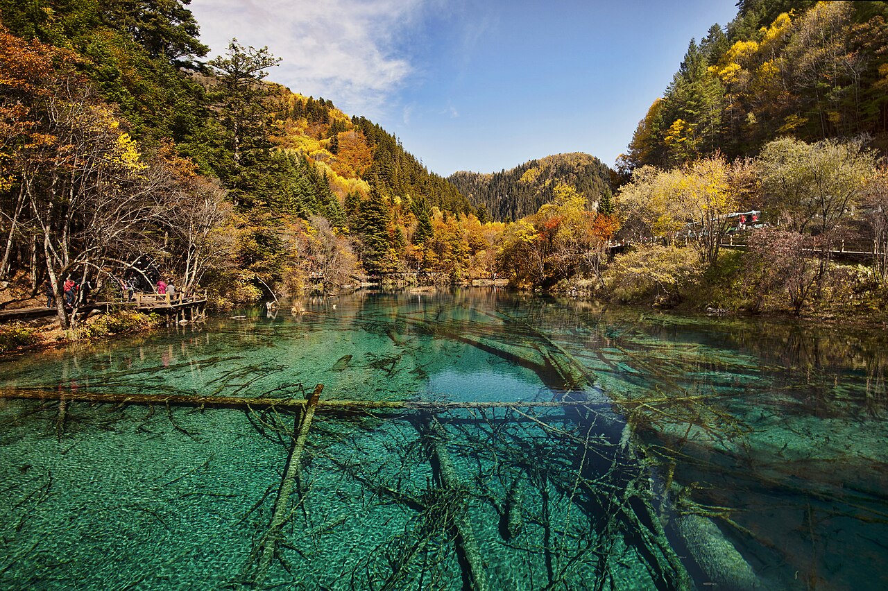
Jiuzhaigou Valley is a nature reserve covering 72,000 hectares in the Min Mountains of northern Sichuan province, China, approximately 330 kilometres north of Chengdu. Its defining feature is a series of multi-coloured lakes and waterfalls produced by calcium carbonate precipitation — the same travertine geology as Croatia’s Plitvice Lakes — with water transparency reaching 20 metres and submerged ancient tree trunks visible from the surface. UNESCO inscribed it as a natural World Heritage site in 1992 and as a Biosphere Reserve in the same year.
Calcium Carbonate, Ancient Trunks, and Water That Changes Colour by Depth Northern Sichuan, 330 km from Chengdu
The name Jiuzhaigou means “Nine Village Valley” in Chinese — a reference to nine Tibetan villages distributed across the three main tributary valleys that form the reserve. The valley system drains southward from the eastern edge of the Tibetan Plateau through the Min Mountains, and the geology of this transition zone is directly responsible for the landscape’s distinctive appearance.
The water flowing into Jiuzhaigou is saturated with calcium carbonate leached from the limestone bedrock of the surrounding mountains. As this supersaturated water flows over the valley floor and loses carbon dioxide — partly through exposure to air, partly through the photosynthetic activity of algae — calcium carbonate precipitates out of solution and accumulates on any surface: fallen logs, submerged boulders, living reeds, the beds of lakes. Over centuries, these deposits build into tufa barriers: natural dams of porous rock that impound the river into a stepped series of lakes at different elevations. As each barrier rises, the lake behind it deepens; as the barrier eventually breaches or is overtopped, a waterfall forms and the cycle of barrier-building begins downstream.
The result is a valley floor covered with approximately 108 lakes, 17 groups of waterfalls, and 11 tufa barrier cascades arranged in a terraced sequence from valley head to valley mouth. The lakes range in colour from deep sapphire blue to turquoise to a bright jade green, depending on depth, the concentration of suspended algae, the angle of sunlight, and the seasonal temperature of the water. Five Flower Lake (Wuhua Hai) is the most visited: shallow enough that its bottom is fully visible, it contains submerged logs encrusted with calcium carbonate that create an otherworldly visual effect — ancient tree trunks suspended in crystalline water, their surfaces white as bone. The lake bottom itself is patterned with algae in different colours, giving the appearance of a mosaic beneath the water surface.
The water transparency at Jiuzhaigou is exceptional: visibility of 20 metres has been recorded in the clearest lakes. This transparency results from the same calcium carbonate chemistry that colours the lakes — the precipitation process removes suspended particulates from the water column, leaving it optically clear. Long Lake (Changhai), the largest lake in the reserve at 7.5 kilometres in length and approximately 103 metres in depth, sits at an elevation of 3,103 metres and retains ice cover for much of the winter. Five-Colour Pond (Wucai Chi), the smallest significant lake in the reserve, is also the most intensely coloured: a concentration of algae in a very shallow, clear basin produces simultaneous patches of deep blue, turquoise, green, and yellow visible from the viewing platforms above.
Wildlife in the reserve includes the giant panda (Ailuropoda melanoleuca), though sightings in the valley proper are rare; the area sits on the western edge of the giant panda’s historical range in the Min Mountains. The reserve also supports populations of Sichuan takin, golden snub-nosed monkey, and over 140 bird species. The Tibetan and Qiang communities who inhabit the nine villages within the reserve use the valley for summer grazing and maintain traditional Buddhist and animist practices — including the veneration of specific lakes and mountains as sacred — that have historically shaped the management of the landscape.
The 2017 Earthquake, the Draining Lakes and the Slow Return of Colour Nearest City: Jiuzhaigou County Seat, 45 km
On 8 August 2017 — the date coincided with Chinese Valentine’s Day (Qixi Festival) — a magnitude 7.0 earthquake struck approximately 9 kilometres northwest of the reserve’s main scenic area. The earthquake killed 25 people, mostly tourists on the valley floor, and injured approximately 543 others. The structural damage to the valley was severe.
The earthquake triggered numerous landslides that dumped rock and soil directly into the lakes and tufa barriers. The natural dams that hold the lakes in position were fractured, causing rapid drainage in several sections. Satellite images taken in the days after the earthquake showed that Huo Hua Hai (Fire Flower Lake) had partially drained, its characteristic turquoise colour replaced by grey sediment. The five-tiered Nuorilang Waterfall — at 270 metres the widest in China — lost much of its travertine facing. Approximately 100 scenic spots within the reserve reported significant damage.
The reserve was closed to tourists immediately after the earthquake. Stabilisation and assessment work by the Jiuzhaigou Administration Bureau, working with geological engineers and hydrologists, identified that the tufa barriers, while fractured, were not irreparably destroyed; the calcium carbonate precipitation process that built them over centuries would, given sufficient time and undisturbed water flow, rebuild them. The question was how long this would take and whether the pace of recovery could be accelerated without introducing further disturbance.
Partial reopening to limited visitor numbers began in September 2019, two years after the earthquake. Recovery has been uneven: some lakes had returned to near-normal colouration by 2020, as the precipitation process re-established clear water above the disturbed sediment layers; others, where landslide debris altered the substrate composition, showed slower recovery. The Nuorilang Waterfall, by 2021, had rebuilt a partial travertine face though not yet to its pre-earthquake volume or appearance. Scientists monitoring the recovery noted that the calcium carbonate deposition rate in undisturbed sections of the reserve — measured at approximately 0.3 to 1 millimetre per year — means that complete restoration of some damaged barriers will take decades.
The earthquake and its aftermath brought renewed attention to the geological fragility of the reserve. The Min Mountains sit on an active tectonic fault system — the same system that produced the devastating 2008 Wenchuan earthquake (magnitude 7.9), centred approximately 150 kilometres to the southeast, which killed nearly 70,000 people and caused catastrophic damage across northern Sichuan. The 2017 Jiuzhaigou earthquake was smaller but occurred directly within the reserve’s catchment area. Ongoing seismic monitoring is now integrated into the reserve’s management systems, alongside the humidity and visitor-density tracking used in other Chinese World Heritage sites.
Huanglong Scenic Area, another UNESCO World Heritage site with travertine lake formations, lies approximately 50 kilometres south of Jiuzhaigou along the same geological corridor. The two sites are typically combined into a single Sichuan highlands itinerary, accessed via Jiuzhaigou Huanglong Airport (JZH), which sits at 3,448 metres elevation — one of the highest commercial airports in China.
Practical information
Jiuzhaigou Valley is approximately 330 kilometres north of Chengdu, or roughly a 4-to-5-hour drive on a mountain road. The fastest option is to fly into Jiuzhaigou Huanglong Airport (JZH), which receives direct flights from Chengdu (30 minutes), Chongqing, and Beijing; the airport sits at high elevation and flights are frequently disrupted by weather — morning departures are more reliable. Bus services from Chengdu’s Chadianzi Bus Terminal take approximately 7 hours and run overnight. The scenic area imposes a strict daily visitor cap (approximately 15,000 since the post-earthquake reopening, reduced from a pre-2017 peak of over 40,000). Tickets must be booked in advance online; foreign visitors should use third-party booking services that accept international payment cards. The two main scenic routes — the Shuzheng Valley and the Zechawa Valley — are each traversable in half a day on foot on the boardwalk systems; electric shuttle buses serve visitors who cannot walk the full routes. Altitude sickness is a consideration: the valley floor sits between 1,990 and 3,100 metres; Long Lake at the valley head reaches 3,103 metres. Allow a day of acclimatisation in Chengdu before visiting. Huanglong, 50 kilometres south, is the standard paired itinerary; it reaches 3,576 metres and altitude effects are more pronounced.
Frequently Asked Questions
Why do the lakes at Jiuzhaigou change colour, and is the colour natural?
The colour of Jiuzhaigou’s lakes is entirely natural and results from a combination of three factors: water depth, suspended algae, and the optical properties of calcium carbonate-saturated water. The fundamental mechanism is Rayleigh scattering — the same process that makes the sky blue. Pure water absorbs red and yellow wavelengths and scatters blue wavelengths; the deeper and clearer the water, the more intensely blue it appears. Jiuzhaigou’s lakes are extraordinarily clear because the calcium carbonate precipitation process removes suspended particulates from the water column, leaving it optically cleaner than tap water. In shallow areas where the lake bottom is visible, the colour shifts toward turquoise or green because the reflected light from the pale travertine bottom mixes with the blue-scattering of the water column above it. The algae communities living in the lake contribute a further layer of colour variation: different algae species produce different pigments (greens, yellows, and ochres), and their distribution across the lake bottom creates the multicoloured mosaic visible from the surface at Five-Colour Pond and Five Flower Lake. Seasonal temperature changes also affect the algae populations and thus the colour intensity. The result is that the same lake can appear measurably different in April (clear, deep blue from snowmelt water) versus September (slightly more turquoise from summer algae growth). The colour is not a trick of photography — visitors consistently describe the lakes as appearing artificially vivid, when in fact the optical conditions are simply more extreme than most freshwater environments in the world.
What is the connection between Jiuzhaigou and the giant panda?
Jiuzhaigou Valley lies within the historical range of the giant panda (Ailuropoda melanoleuca) in the Min Mountains of northern Sichuan — one of the six isolated mountain ranges where remnant wild panda populations survive. The reserve was partly designated for its giant panda habitat alongside its geological and hydrological values; UNESCO’s 1992 inscription cited both the travertine lake system and the biodiversity of the mixed broadleaf-conifer forest that covers the valley slopes. However, it is important to be accurate about visitor expectations: giant pandas in Jiuzhaigou’s valley proper are extremely rarely seen by tourists. The animals are shy, have very large home ranges relative to the core tourist zone, and prefer bamboo thickets at higher elevations away from visitor boardwalks. Sightings in the scenic area are genuinely exceptional. The main panda populations in the Min Mountains are monitored by researchers in the buffer zone and the surrounding nature reserve area, not in the tourist corridors. Visitors who want a reliable panda encounter are better served by the Chengdu Research Base of Giant Panda Breeding, approximately 10 kilometres from Chengdu city centre, which maintains a large captive-breeding and research facility with guaranteed viewing. Jiuzhaigou is correctly understood as a panda-habitat landscape — an area whose forest health supports the species’ survival — rather than a panda-viewing destination in the conventional sense.
Has Jiuzhaigou fully recovered from the 2017 earthquake?
As of the time of publication, the recovery is ongoing and uneven. The 8 August 2017 magnitude-7.0 earthquake caused significant structural damage to approximately 100 scenic spots, including tufa barriers, lake beds, and waterfall faces. The reserve reopened to limited visitor numbers in September 2019, and monitoring data collected since then indicates partial recovery in several lake systems. The Five Flower Lake (Wuhua Hai) was among the sites that showed relatively rapid colour recovery, as the intact portions of its calcium carbonate substrate allowed precipitation to resume relatively quickly. The Nuorilang Waterfall, which lost a large section of its travertine facing, had rebuilt a partial flow structure by 2021 but had not returned to its pre-earthquake visual form. Lakes where landslide debris altered the substrate composition — changing the chemical balance available for precipitation — are recovering more slowly. Scientific models based on measured deposition rates of 0.3 to 1 millimetre per year in undisturbed zones suggest that some damaged barriers may take 20 to 50 years to fully rebuild. The visitor cap of approximately 15,000 per day (reduced from a pre-2017 peak over 40,000) was set partly to reduce the mechanical stress of foot traffic on recovering travertine surfaces, and partly because sections of the boardwalk system remain closed for safety reasons in areas where landslide risk has not been fully assessed.
Sources
- S1 — Jiuzhaigou National Park Administration Bureau — Official Ecology & Heritage Conservation Portal — https://www.jiuzhai.com/
- S2 — Terry B. Dingwall et al. — Protected Areas of East Asia, IUCN, Gland, 2005, ISBN 978-2831708812
Spotted an error? Write to editorial@culturalheritageonline.com and we correct it the same day.