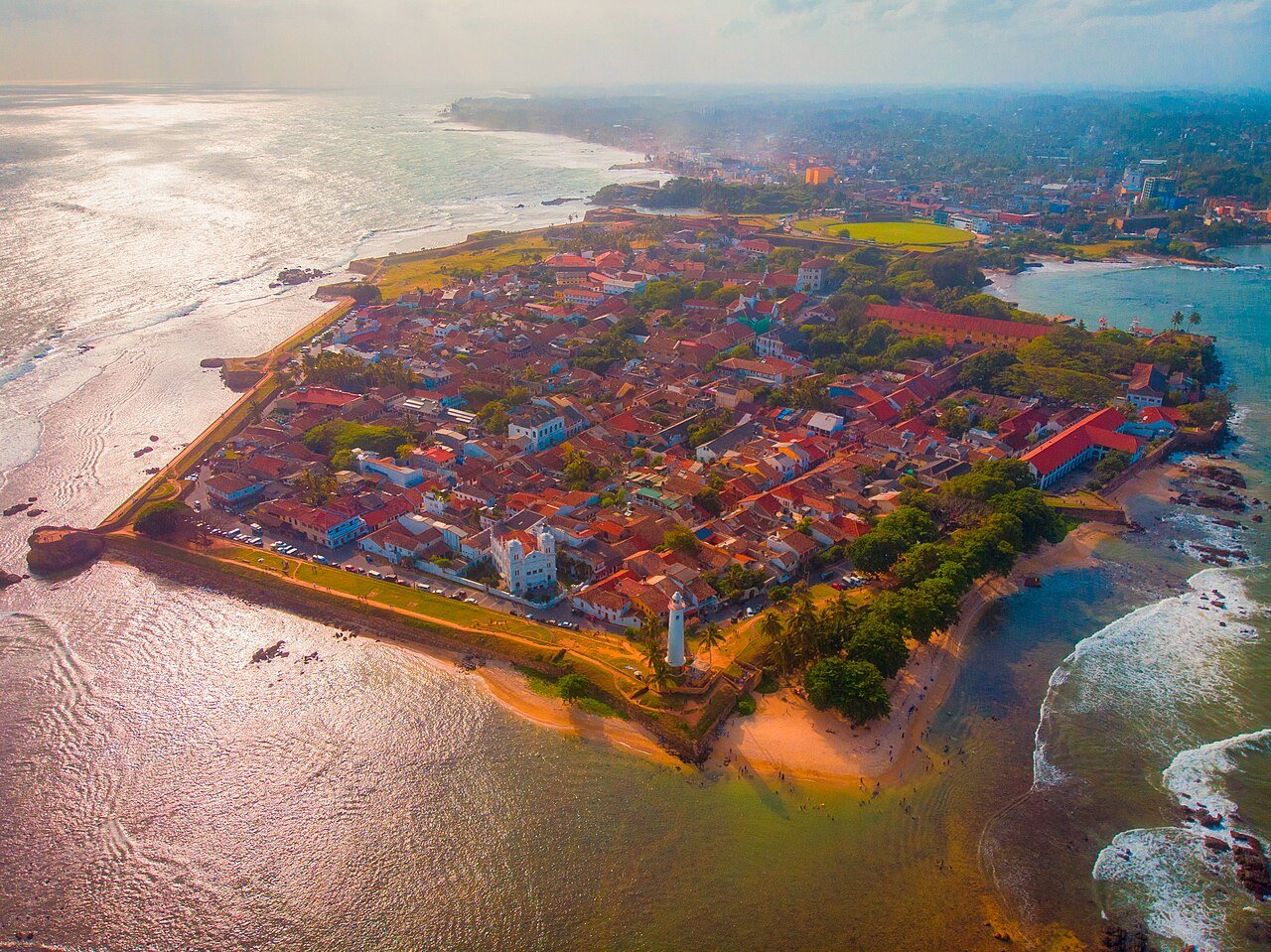
Galle Fort, listed as a UNESCO World Heritage Site in 1988, occupies a 52-hectare peninsula on Sri Lanka’s southwest coast. The Portuguese laid the first masonry fortifications here in 1588; the Dutch captured it in 1640 and systematically rebuilt the entire rampart system by 1663; the British took it in 1796 and left the Dutch layout almost entirely intact. Three colonial powers worked on this peninsula over 208 years, and the result is a fortified town with 36 listed monuments still inhabited by roughly 400 families.
Inside the Walls: Three Centuries of Layered Colonial Architecture Within the fort perimeter, 52 hectares
The Portuguese chose this headland for strategic reasons that still read clearly from the air: the fort sits on a rocky promontory with the sea on three sides, giving defenders sightlines over the southern Indian Ocean approaches. Their original earthwork fort of 1588 was modest. When the Dutch East India Company (VOC) fleet under Admiral Cornelis Speelman defeated the Portuguese garrison in 1640, the VOC began a fifty-year project to turn Galle into one of its most important trading posts in Asia. The three main bastions — Star, Sun, and Moon — date from this period, and the walls were thick enough to absorb cannon fire without collapse. Dutch engineers brought techniques refined in the Netherlands and applied them to local coral limestone and granite.
The Dutch Reformed Church inside the fort was built in 1755, making it one of the oldest Protestant churches in Asia still in regular use. The tombstones inside the church and in the adjacent Dutch cemetery record family names — de Vos, Ondaatje, van der Sanden — that recur in Galle’s contemporary population. Roughly 90 families in and around Galle today trace documented ancestry to Dutch settlers or soldiers who remained after the VOC period ended. The Dutch Governor’s Mansion, the warehouse buildings along Leyn Baan Street, and the water gate (Zwart Bastion) are among the most complete surviving examples of VOC civic architecture outside the Netherlands. The British captured the fort in 1796 as part of the broader redistribution of Dutch colonial possessions during the Napoleonic Wars, but unlike their practice elsewhere in the empire, they did not demolish the existing town or replace its layout. British additions — notably the lighthouse built in 1848, which remains operational 162 years after construction — were inserted into the Dutch urban fabric rather than imposed over it.
The result is what UNESCO’s inscription committee identified as a unique example of an interaction between European architectural styles and South Asian traditions: Sinhalese Buddhist shrines coexist within the walls with a mosque, the Dutch Reformed Church, and buildings that combine Dutch gabled facades with Sinhalese verandas. The fort is emphatically not a museum. Lawyers have offices on Leyn Baan Street, schoolchildren walk through the main gate, and the lighthouse keeper’s house is occupied. The 400 resident families make Galle one of the few UNESCO-listed fortified towns in Asia with a living urban population rather than a preserved historic district cleared of residents.
The 2004 Indian Ocean Tsunami tested the fort’s engineering in a way its Dutch builders could not have anticipated. Waves from the tsunami — which killed more than 30,000 people in Sri Lanka and completely destroyed several coastal towns nearby — broke over the sea-facing walls but did not breach them. The mass of the bastions deflected the worst energy, and the interior of the fort sustained relatively limited structural damage. The town immediately outside the walls suffered catastrophic destruction. The contrast was stark enough that structural engineers subsequently studied the fort’s geometry as a case study in tsunami-resilient design.
Sri Lanka’s Other UNESCO Sites: Rainforest and Royal Capital Within a Day’s Travel 60–150km north of Galle
Sinharaja Forest Reserve, inscribed in 1988, begins approximately 60 kilometres north of Galle in the island’s Wet Zone. It is the last remaining viable tract of tropical lowland rainforest in Sri Lanka — a country that has lost more than 80% of its original forest cover since the colonial period. The reserve covers 8,864 hectares and receives between 2,500 and 5,000 millimetres of rain annually, figures that sustain one of the most species-dense ecosystems in South Asia. Sixty percent of Sri Lanka’s endemic tree species are found in Sinharaja. Among the forest’s documented animal life are 21 of the island’s 26 endemic bird species, 25 endemic mammal species, and a phenomenon unusual in any forest globally: mixed-species bird flocks in which up to 15 different species move and feed together through the canopy. The ecological relationship underlying this behaviour is not fully understood, but it appears that smaller species gain predator detection advantages by travelling with species that alarm-call differently.
Sinharaja’s survival is partly the result of public mobilisation. The forest was logged commercially from 1971 to 1977, reducing canopy in portions of the reserve. Organised protests — unusual in scale for Sri Lanka at the time — led the government to halt logging in 1977 and designate Sinharaja a Biosphere Reserve the following year. It received UNESCO listing a decade later. The name itself, translated from Sinhala, means “Lion Kingdom,” and the forest appears in historical records as a protected crown reserve as far back as 1875.
Further north, 100 kilometres from Galle, the Central Highlands of Sri Lanka — a composite UNESCO site inscribed in 2010 comprising the Peak Wilderness Protected Area, Horton Plains National Park, and the Knuckles Conservation Forest — mark the ecological and topographic heart of the island. The highest point in Sri Lanka, Pidurutalagala at 2,524 metres, sits within this zone. Horton Plains, a plateau at approximately 2,100 metres, ends at the World’s End escarpment, where the land drops 880 metres to lowland jungle in a near-vertical cliff. This landscape is also where the British colonial administration made one of the most consequential agricultural decisions in South Asian history: after the fungal disease Hemileia vastatrix (coffee leaf rust) destroyed virtually the entire Ceylon coffee industry between 1869 and 1879, planters switched to tea. The Camellia sinensis cultivar they adopted, grown in estates across the highlands, ultimately made Ceylon Tea one of the most recognisable commodity brands in the world.
Kandy, 150 kilometres north of Galle, holds the Temple of the Sacred Tooth Relic and has been a UNESCO World Heritage Site since 1988. The relic — a tooth attributed to the historical Buddha — was brought to Sri Lanka from India in the 4th century CE, reportedly smuggled inside the hair of a princess. The Dalada Maligawa temple that houses it was rebuilt repeatedly after Portuguese raids and British bombardment; the current structure largely dates from the 18th-century Kandyan period. Kandy served as the last independent royal capital of Sri Lanka until British forces captured it in 1815, ending the Kandyan Kingdom. The city’s annual Esala Perahera festival, held in July or August, draws one of the largest Buddhist processions in Asia.
Practical Information Galle Fort, Southern Province, Sri Lanka
Galle is 116 kilometres south of Colombo by the Southern Expressway, approximately 90 minutes by car. Trains on the coastal line from Colombo Fort station to Galle take roughly three hours and are a practical option. The fort itself is free to enter at all times. The lighthouse is not open to the public. The Dutch Reformed Church is open to visitors outside service hours. Most of the fort’s buildings are privately owned and not accessible; the experience is primarily one of walking the ramparts and streets.
Sri Lanka requires no advance visa for most nationalities — the Electronic Travel Authorization (ETA) is issued online within minutes. The currency is the Sri Lankan Rupee. English is widely spoken in Galle Fort. The best season for the south coast is November through April, when the southwest monsoon has passed. The Unawatuna Bay beaches are 4 kilometres east; Weligama, known for surf and surf schools, is 15 kilometres further. Mirissa, 20 kilometres from Galle, is the departure point for blue whale watching excursions; blue whales and sperm whales pass in the waters south of Sri Lanka from November through April, with the blue whale population among the largest reliably accessible in the world. Accommodation inside the fort ranges from heritage guesthouses in restored Dutch-period buildings to boutique hotels; booking several months ahead is advisable for December–January peak.
Frequently Asked Questions
What makes Galle Fort architecturally distinct from other European colonial forts in Asia?
Most European colonial forts in Asia were either dismantled by subsequent colonial powers or converted into military barracks and administrative buildings that erased earlier layers. Galle’s architecture is unusual because three distinct colonial regimes — Portuguese (1588–1640), Dutch (1640–1796), and British (1796–1948) — each added to the existing fabric without wholesale demolition. The Portuguese earthwork foundations underlie the Dutch stone ramparts; the British inserted their lighthouse and administrative buildings into streets that follow the Dutch-period plan. The urban morphology is consequently a stratified record of three different European approaches to colonial town planning. The Dutch contribution is the most dominant: the rampart geometry, the street grid, the system of drainage canals, the location of the church and the governor’s residence, and the typology of the merchant houses all reflect VOC practice from the late 17th century. What makes it specifically distinct is the simultaneous presence of a functioning Sinhalese Buddhist shrine, a mosque, and a Dutch Reformed Church within the same 52-hectare walled perimeter — a spatial coexistence that would have been impossible in the segregated colonial cities of India. UNESCO’s 1988 citation described it as “a unique blend of European architecture and South Asian traditions.”
How did the 2004 Indian Ocean Tsunami affect Galle Fort and the surrounding area?
The tsunami of 26 December 2004, triggered by a 9.1-magnitude undersea earthquake off Sumatra, struck the Sri Lankan coast with waves estimated at 10–12 metres in some locations. The area around Galle suffered some of the worst casualties in Sri Lanka; the town outside the fort walls and the coastal road north toward Colombo were devastated. Inside the fort, the situation was different. The walls — built from coral limestone and granite to a height of approximately 12 metres at the sea-facing bastions — absorbed and deflected the wave energy. Water entered the fort over the lower sections of the wall and through the main gate, damaging ground-level buildings and covering streets to a depth of roughly one metre, but the structural damage to the fort’s 36 listed monuments was limited. No deaths inside the fort perimeter were reported. The contrast with the destruction immediately outside drew immediate attention: a cricket match being played in the stadium adjacent to the fort was interrupted when tsunami waves entered the ground from the sea side, killing several spectators, while the fort interior remained largely intact. Engineers subsequently documented the bastions’ geometry as a natural wave-energy diffuser, a finding that has influenced discussions about coastal infrastructure design in tsunami-risk zones.
What is the best practical strategy for visiting Galle Fort alongside Sinharaja Forest Reserve in a single trip?
The two sites are 60 kilometres apart by road — approximately 90 minutes via the B153 highway through Udugama. A logical approach is to base yourself in Galle for two nights, exploring the fort on arrival, then hire a vehicle for a full day in Sinharaja. Entry to Sinharaja requires a permit purchased at the reserve entrance; the main entry points are Kudawa (northwest) and Pitadeniya (south). Guides are mandatory and available at both entrances; the morning hours (departure by 7:00) produce the best bird-watching and the highest chance of encountering the mixed-species flocks. The forest trails are not strenuous but the ground is consistently wet — waterproof footwear is essential year-round, not just during monsoon. Return to Galle by late afternoon. From Galle, the Central Highlands are 3–4 hours north via Ratnapura; adding Horton Plains requires at least one night in Nuwara Eliya. Kandy is a further 2 hours from the highlands. A practical circuit covering all four Sri Lankan UNESCO sites — Galle, Sinharaja, Central Highlands, Kandy — takes a minimum of six days and works best with a hired vehicle rather than public transport, which does not serve Sinharaja directly.