Between 961 and 1064 CE, Ani was one of the most populous cities in the world — a medieval Armenian capital on the high plateau of eastern Anatolia whose population of perhaps 100,000 to 200,000 people made it a peer of Constantinople and Baghdad. Seljuk conquest, Mongolian destruction, and a catastrophic earthquake in 1319 CE left it empty. Today its ruins stand on the Turkish-Armenian border, across a gorge from the country that built it, wind-scoured and largely unreachable from the Armenian side. UNESCO inscribed the Ruins of Ani in 2016.
The Bagratid Capital: From Founding to Conquest Kars Province, eastern Turkey · 45 km from Kars city
The Armenian Bagratid dynasty chose Ani as their capital in 961 CE, relocating the royal seat from Kars to take advantage of Ani’s defensible position on a triangular promontory cut on two sides by the deep gorges of the Akhurian River and the Bostanlar gorge. The promontory was ringed by walls; the landward approach — the only side without natural cliffs — was sealed by massive double fortifications whose construction the Bagratid kings invested in continuously over the following decades. The inner “Anastasius Wall,” named in some sources for the construction activity around 972 CE, and the outer wall completed around 989 CE gave the city one of the most formidable defensive systems in medieval western Asia. The walls still stand along much of their length, the coursed basalt masonry barely disturbed by a thousand years of weather.
The peak of Bagratid power coincided with the peak of Ani’s urban development. Under King Gagik I (989–1020 CE), the city expanded rapidly; under Gagik II (1042–1045 CE), the Bagratid kingdom began to fracture under pressure from Byzantium to the west and the emerging Seljuk power to the east. The Seljuk Turks under Sultan Alp Arslan besieged Ani in August 1064 CE. The siege lasted 25 days — a remarkably short time given the walls’ reputation — and ended when a section of the wall was breached. Medieval sources describe the sack that followed in terms of mass killing and enslavement; the Armenian population was dispersed across the region, and the city never regained its former density even when briefly restored to Armenian or Georgian control in later decades.
The Georgian Kingdom of the 12th and 13th centuries brought a partial recovery to Ani: churches were built, trade routes reopened, and the city functioned again as a regional center under Georgian suzerainty. The Church of St Gregory of the Abughamrents (1215 CE), with its distinctive Georgian architectural features fused with the Armenian stone-carving tradition, dates from this period of Georgian patronage. But the Mongol invasions of the 13th century — Ani was sacked and depopulated in 1239 CE — ended the Georgian revival, and the earthquake of 1319 CE destroyed enough of the remaining standing architecture to make resettlement economically unthinkable. The city’s abandonment was then complete and permanent. Nomadic Turkic groups grazed animals across the ruins for centuries; the site was administered by various local powers without any attempt at urban reoccupation.
The Cathedral of Ani and the Architect Trdat Within the walled ruins · permit required; military checkpoint on approach road
The Cathedral of Ani was built between 989 and 1001 CE, commissioned by the Bagratid Queen Katranide and designed by the architect Trdat. The cathedral is the building that anchors Ani’s reputation in the global history of architecture, and Trdat is the name that anchors the cathedral’s significance: he was commissioned, some years after completing the Ani Cathedral, to repair the dome of Hagia Sophia in Constantinople following the earthquake of 989 CE. An Armenian architect working in the tradition of Armenian church design was thus responsible for maintaining the structural integrity of the greatest building in the Byzantine world — a commission that reflects both the technical reputation of Armenian builders in the medieval eastern Mediterranean and the cross-cultural architectural exchange of the period that modern national narratives often prefer to forget.
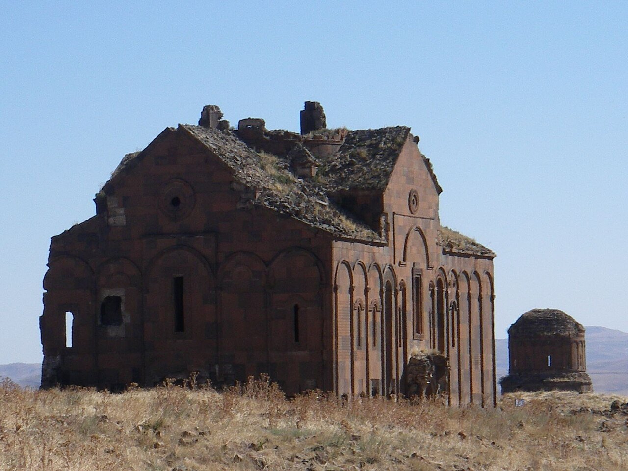
The Cathedral of Ani is a large basilica of pink and grey tuff stone, its exterior surfaces articulated with blind arcades, engaged columns, and relief carvings. The interior, now roofless, shows Trdat’s structural ambitions clearly: clustered piers carry pointed arches that anticipate — or parallel — the Gothic structural logic that was emerging in western Europe at roughly the same period. Whether Armenian pointed arch construction influenced western Gothic development is a question that architectural historians have debated without resolution; what is uncontested is that Trdat’s cathedral shows a clear understanding of how to channel vault thrust through piers and arches rather than through massive wall thickness, which was the structural insight that made Gothic height possible. The dome that originally covered the cathedral has collapsed; the drum and pendentives survive and show the same technical refinement as the lower structure. The carved ornament on the west portal — inhabited vines, geometric interlace, and figural reliefs — represents the fully developed Armenian stone-carving tradition at its most elaborate.
The broader ruins of Ani reward careful walking. The double walls at the northern approach still carry their full height in sections, with the original battlements and arrow slits intact. The Church of the Redeemer (Surp Prkich), a round church of the early 11th century, split precisely in half by lightning in 1957: one half still stands to its full height, the other is a pile of shaped stone beside it, creating one of those involuntary architectural comparisons that archaeology occasionally produces. The Seljuk palace remains, the caravanserai foundations, the traces of the bazaar quarter — the archaeological density of the site is extreme, and the nearly complete absence of modern construction within the ruins means that the medieval urban plan is still legible in the landscape.
The site’s political geography adds a dimension that few UNESCO properties share. Ani sits in Turkey, on the border with Armenia; the Akhurian River in the gorge below the southern walls is the international border. On clear days, visitors on the Turkish side can see the Armenian village of Anipemza directly across the gorge, where the ruins are visible from the opposite bank but inaccessible — the border has been closed since 1993. The Turkish and Armenian governments have not established diplomatic relations; the border is sealed. Ani thus presents its medieval greatness to the country that does not claim it as national heritage, while the people who do claim it as part of their historical memory can view it only from a distance.
Practical information
Ani is 45 km east of Kars, the nearest city, in Kars Province of eastern Turkey. Kars is reachable by air from Istanbul and Ankara (Turkish Airlines and Pegasus operate the route); the flight takes approximately two hours. There is also a train from Ankara to Kars — a scenic but long journey of 24–26 hours on the Doğu Express, which has become popular with Turkish domestic travelers. From Kars, Ani is accessible by taxi or organized tour; public transport to the site does not run regularly. Entry to the ruins requires purchasing a ticket at the site gate and passing a military checkpoint on the approach road — the border proximity means security presence is consistent and visitors should carry their passport. Photography is generally permitted within the ruins, but military and border infrastructure is off-limits.
The best seasons to visit are May to June and September to October. July and August bring extreme heat on the exposed plateau — temperatures above 35°C with no shade in the ruins. Winter (November to March) sees heavy snow and temperatures well below freezing; access roads may be impassable. The site is large and unshaded; two to three hours minimum is needed to walk the cathedral, the walls, the Church of the Redeemer, and the main excavated areas. Bring water, sunscreen, and sturdy footwear for uneven terrain. The nearest accommodation is in Kars, which has a range of hotels; the city itself has significant Armenian, Russian, and Ottoman-era architecture worth exploring. Kars is also a base for visiting the Kars Castle and the Sarıkamış area, making a multi-day itinerary in the region practical.
Frequently Asked Questions
Who was the architect Trdat, and what is his connection to Hagia Sophia?
Trdat was an Armenian architect active in the late 10th and early 11th centuries, known from documentary sources as the designer of the Cathedral of Ani and the Church of the Holy Apostles at Kars. His most remarkable documented commission came after the Ani Cathedral was completed: the Byzantine emperor Basil II engaged him to repair the dome of Hagia Sophia in Constantinople, which had been seriously damaged by the earthquake of 989 CE. The Byzantine chronicler John Skylitzes records that the dome’s western arch had collapsed and that an architect — identified in Armenian sources as Trdat — was brought to Constantinople to carry out the repair. This is an extraordinary appointment on several levels. Hagia Sophia, completed in 537 CE under Justinian I, was the largest enclosed space in the world and the symbolic center of Byzantine Christianity; any structural intervention in it carried enormous political and religious weight. That the Byzantine court chose an Armenian architect — a subject of a neighboring Christian kingdom — reflects both the high technical reputation of Armenian builders in the eastern Mediterranean and the practical reality that skilled structural architects of this caliber were rare and known across political boundaries. The repair Trdat executed held: the Hagia Sophia dome survived without major intervention until the Ottoman period. His work at Ani, particularly the cathedral’s pointed arches and clustered pier system, suggests a structural intelligence that would have been well suited to the demands of stabilizing a large Byzantine dome.
How did the Mongol invasions and the 1319 earthquake affect Ani?
Ani’s decline after the Seljuk conquest of 1064 CE was not a single catastrophic event but a series of shocks spread over two and a half centuries. The Seljuks used the city as a regional administrative center and conducted some repairs; the Georgian kingdom of Queen Tamar (reigned 1184–1213 CE) captured Ani in 1199 CE and sponsored a cultural revival that produced the Church of St Gregory of the Abughamrents and restored some of the city’s commercial life. The first Mongol passage through eastern Anatolia in the 1220s was devastating: sources describe massacre and plunder, though exact population counts are impossible. A second and more thorough Mongol campaign in 1239 CE destroyed enough of the city’s infrastructure and drove off enough of its population that the Georgian cultural revival ended definitively. Ani continued to have some inhabitants and some commercial function under Mongol and later Ilkhanate administration through the late 13th century, but at a fraction of its Bagratid-era population. The earthquake of 1319 CE struck the region with sufficient force to collapse vaults, crack walls, and topple the upper portions of church towers. Contemporary sources do not give casualty figures for Ani specifically, but the structural damage was apparently enough to make reconstruction economically unjustifiable for a city that was already depopulated. By the mid-14th century, the site was functionally abandoned. The ruins then entered centuries of agricultural use and episodic stripping of dressed stone for construction elsewhere in the region — a common fate for abandoned ancient cities that accelerated Ani’s decay before archaeological attention began in the 19th century.
Why is Ani located in Turkey but considered part of Armenian cultural heritage?
Ani was the capital of the Armenian Bagratid kingdom from 961 to 1064 CE and remained a city with a substantial Armenian Christian population through its subsequent periods of Seljuk, Georgian, Mongol, and Ottoman rule. Eastern Anatolia was historically a zone of mixed population — Armenian, Kurdish, Turkish, and other communities overlapping across the same landscape — and the question of which modern nation-state’s “heritage” a medieval city represents is itself a modern question imposed on a pre-national reality. The territory where Ani stands became part of the Republic of Turkey after the First World War and the Turkish-Armenian War of 1920–1921, which also saw the closure of the Turkish-Armenian border. Armenia, as a Soviet republic and later as an independent state, has consistently claimed Ani as part of its national historical memory and has repeatedly called for greater access to and conservation of the site. Turkey administered Ani with varying degrees of care through the 20th century; for decades the site was under military control and difficult to visit, which contributed to significant deterioration. The UNESCO inscription in 2016 came after years of advocacy by Armenian cultural organizations and international heritage bodies, and it was accepted by Turkey as the site’s steward — which requires a degree of political acknowledgment of the site’s significance that the previous military-zone designation had effectively suppressed. Conservation work has increased since 2016, though the border remains closed and Armenians can still only view their former capital from the opposite bank of the Akhurian gorge.
Sources
- S1 — Kalantar, Ashkharbek. Armenia: From the Stone Age to the Middle Ages. Recherches et Publications, 1994. ISBN 978-2-940032-01-3.
- S2 — Cowe, S. Peter, ed. Ani: World Architectural Heritage of a Medieval Armenian Capital. Peeters, 2001. ISBN 978-90-429-1038-6.
Spotted an error? Write to editorial@culturalheritageonline.com and we correct it the same day.