The Curonian Spit is a 98-kilometre narrow sand peninsula separating the Curonian Lagoon from the open Baltic Sea, formed by wind and wave action over 5,000 to 8,000 years. Shared between Lithuania and Russia (Kaliningrad Oblast), it was inscribed as a UNESCO World Heritage Site in 2000 for its exceptional natural dune landscape and the centuries-long human effort to prevent its complete burial under shifting sand. In places less than 400 metres wide, the spit carries some of the tallest shifting dunes in Europe — up to 60 metres high — along with pine forests planted from the 1820s onward to stabilise sand that had already consumed entire villages.
Sand in Motion: The Dunes and the Villages They Buried Curonian Spit National Park, Lithuania
The Curonian Spit extends from the port city of Klaipėda in the north to Zelenogradsk (formerly Cranz) in the south, crossing the border between Lithuania and the Russian exclave of Kaliningrad Oblast roughly two-thirds of the way along its length. Its entire surface rests on sand accumulated over millennia by the combined action of Baltic Sea currents, prevailing westerly winds, and the longshore drift of material from eroding coastal cliffs further north. The spit is not ancient in geological terms — it formed within the last eight millennia, a relatively recent feature in landscape history — and it is not stable. It is a living landform, constantly reworked by the forces that created it.
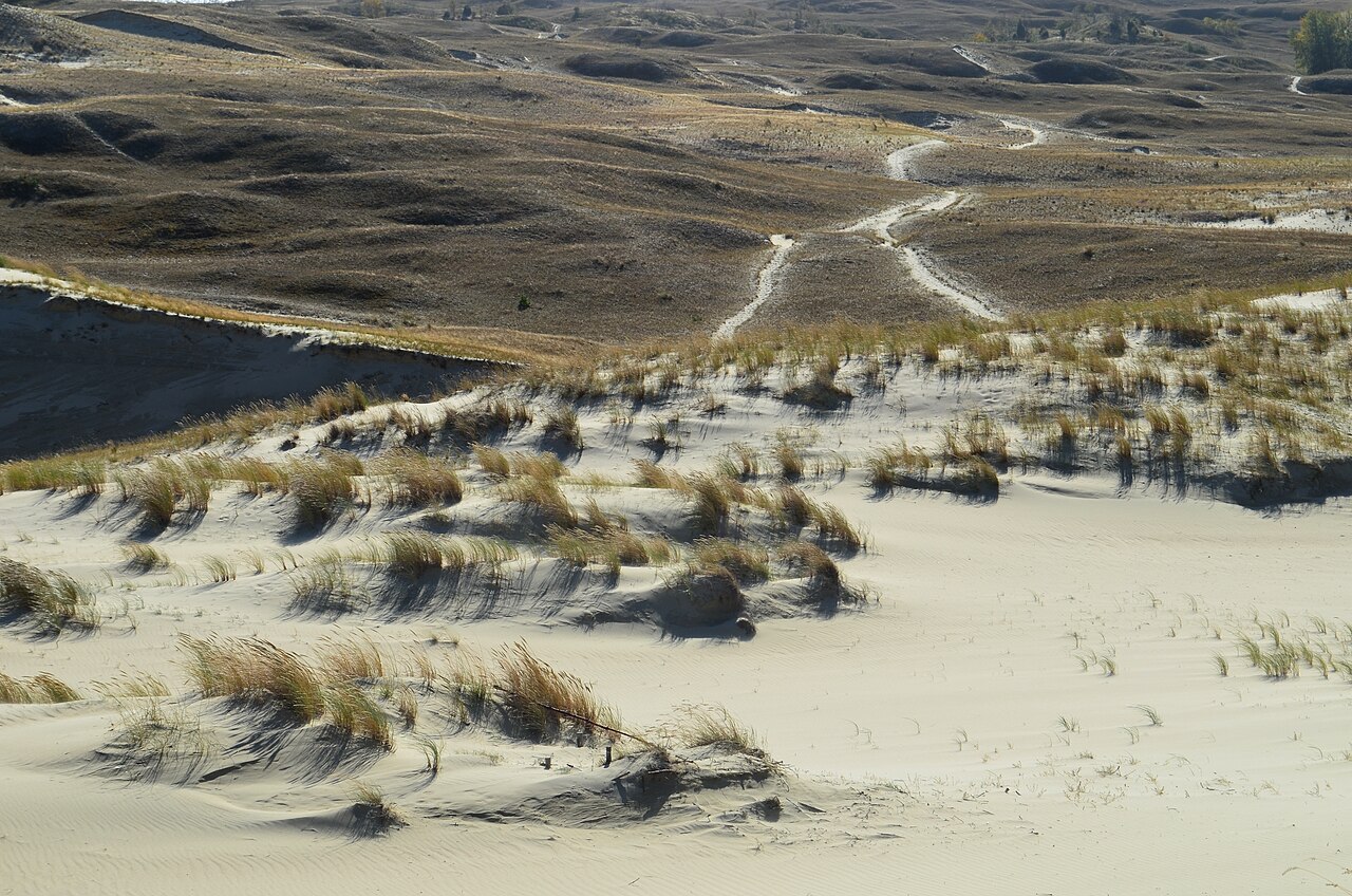
The “Great Dunes” — the Didžiosios kopos — form the most visually dramatic section of the Lithuanian part of the spit, concentrated between the village of Juodkrantė and the town of Nida in the south. These are not fixed, vegetated dunes of the coastal European type but active migrating dunes: bare or sparsely vegetated masses of sand that move measurably year by year under wind pressure, advancing across the spit toward the lagoon shore. The tallest reach nearly 60 metres above sea level. The Parnidis Dune at the southern end of Nida, at 52 metres, is the most accessible of the large dunes — a marked path climbs from the town to the crest, where a stone sundial installed in 1995 marks the landscape boundary between Lithuania and the Kaliningrad region, and where views extend across the shallow brown expanse of the lagoon to the east and the grey Baltic to the west.
The dunes’ human history is one of progressive destruction followed by extraordinary recovery. In the eighteenth and nineteenth centuries, the combination of intensive local timber cutting (stripping the pine and oak forests that had stabilised the sand for centuries) and increased pastoral pressure on what remained caused the Great Dunes to begin advancing at rates measured in tens of metres per year. Villages that had existed on the spit for generations found themselves in the path of slow-moving walls of sand. The village of Karvaičiai, between Juodkrantė and Nida, was engulfed in the eighteenth century; contemporary accounts describe the church steeple remaining visible above the dune surface for years after the rest of the village had been buried. Nagliai, Įsiltis, and other settlements disappeared entirely. By the early nineteenth century the spit faced a genuine ecological crisis: without intervention, the advancing dunes would have buried the remaining inhabited areas and sealed the lagoon mouth, destroying the fishing economy that supported the local population.
The response was systematic reforestation, beginning in the 1820s under Prussian administration. Forest master Georg David Kuwert developed a technique of first stabilising the dune surface with marram grass and other pioneer plants, then planting rows of pine seedlings behind that initial protective cover. The programme worked over decades rather than years: it required persistent effort across multiple generations of foresters, but by the end of the nineteenth century the bare dune sand had largely been brought under a forest canopy, and the rate of dune advance had been dramatically reduced. The pine forests that cover most of the spit today — the ones visitors walk through on the marked trails between dune viewpoints and lagoon beaches — are the legacy of that industrial-era stabilisation project, not ancient woodland.
Thomas Mann’s Summer House and the Historical Population of the Spit Nida, Lithuania — 50 km south of Klaipėda
The town of Nida, at the Lithuanian end of the spit, occupies a site that has been inhabited since at least the medieval period. The area was historically settled by the Curonian people — a Baltic tribal group who gave both the lagoon and the spit their names — and from the fourteenth century onward was progressively colonised by German-speaking settlers under Teutonic and later Prussian administration. By the nineteenth century the community was predominantly German-speaking and Protestant, known in German as Nidden, and engaged primarily in fishing the exceptionally productive lagoon waters. The lagoon’s low salinity and shallow depth supported large populations of pike, bream, and eel, and the fishing technique developed on the Curonian Spit — the Kurėnas, a flat-bottomed sailing boat with a distinctive angled sail — became one of the most recognisable craft forms of the eastern Baltic.
Nidden began attracting artists and writers in the late nineteenth century, when the combination of dramatic dune landscape, clear lagoon light, and relative isolation from urban Germany made it a destination for landscape painters. The artist colony that developed there was modest compared to those of Worpswede or the Brücke group’s coastal refuges, but it brought enough cultural attention that when Thomas Mann, already a Nobel laureate (1929), was looking for a summer retreat, Nida was among the places suggested. Mann had the summer house built in 1930 on a hill above the lagoon shore and spent the summers of 1930, 1931, and 1932 there with his family. During these summers he worked on the early volumes of his novel cycle “Joseph and His Brothers,” a retelling of the biblical Joseph narrative in four volumes published between 1933 and 1943.
Mann’s connection to Nida ended with the political situation in Germany. He left for a lecture tour to the United States in early 1933, shortly after Hitler’s appointment as Chancellor, and did not return. The house passed through various hands during the German occupation and Soviet period and is now the Thomas Mann Memorial Museum, operated by the Lithuanian government and open to visitors from May to October. The interior has been restored to approximate its 1930s appearance, and the hillside setting above the lagoon remains largely unchanged — the view from the terrace that Mann looked out on while working is the same expanse of still water and reed beds that it was in 1932.
The entire population of the German-inhabited spit was expelled in 1945, following the Soviet occupation of the Memel region (Lithuania had annexed the Memel territory from Germany in 1923; Soviet forces occupied it in 1945). The fishing communities that had lived on the spit for five centuries were displaced westward. The Lithuanian part was repopulated with settlers from other parts of Lithuania and the Soviet Union, and the traditional fishing culture was largely discontinued. What remains is landscape, architecture, and the Mann house: the human continuity was broken.
Practical information
The Curonian Spit is reached by ferry from the port of Klaipėda, on the Lithuanian coast; ferry crossings take approximately 10 minutes and run year-round at frequent intervals. From the northern ferry landing, the main road (Highway 167) runs the full length of the Lithuanian spit to Nida, 50 km south. Buses connect the main settlements — Smiltynė, Juodkrantė, Nida — several times daily in summer, less frequently in winter. Cars are admitted to the spit but require a fee to enter the national park; bicycles are the most practical way to travel between points within the spit and can be rented in Nida and Juodkrantė. From Nida, a border crossing into the Russian Kaliningrad section of the spit was available to EU citizens until the closure of the Nida–Morskoe crossing following changes in Russian border policy from 2022 onward — check current border status before planning to cross. The Parnidis Dune is a 20-minute walk from the centre of Nida. The Thomas Mann Memorial Museum is open daily from May to October. The nearest UNESCO World Heritage Site is the Kernave Archaeological Site, approximately 200 km south by road via Klaipėda and Vilnius.
Frequently Asked Questions
How was the Curonian Spit formed, and why is it considered geologically unusual?
The Curonian Spit formed through a combination of processes operating over approximately 5,000 to 8,000 years. At the end of the last Ice Age, as the Baltic basin was draining and the coastline stabilised into roughly its modern configuration, longshore drift currents running parallel to the eastern Baltic shore began accumulating sand from eroding coastal cliffs to the north. This sand was deposited in a growing submarine bar that eventually broke the surface and extended southward, driven by the prevailing wind and current direction. As the bar grew and accumulated further material, it separated the shallow bay behind it from the open sea — creating the Curonian Lagoon — while continuing to grow in both directions along the coast. The result is a spit that is today 98 km long and between 400 metres and 4 km wide, composed entirely of sand and built without any underlying bedrock foundation. What makes it geologically unusual is this combination of extreme length, extreme narrowness, and the complete absence of any hard substrate: the spit sits entirely on its own accumulated sand, held together by vegetation (where it exists) and the dynamic equilibrium between Baltic wave energy and lagoon-side sheltering. This also makes it inherently vulnerable: any significant disruption to the balance of sand supply, vegetation cover, or wave energy can trigger rapid change. The deforestation episodes of the seventeenth to nineteenth centuries demonstrated this in the most direct way possible, when the removal of the stabilising forest cover allowed the dunes to advance at rates that buried entire villages within decades.
What happened to the German-speaking population that lived on the Curonian Spit before 1945?
The German-speaking communities of the Curonian Spit had roots stretching back to the Teutonic Order’s eastward expansion in the fourteenth century, with some settlements predating German colonisation entirely as Curonian fishing villages that were later absorbed into German cultural and administrative structures. By the nineteenth century the population was predominantly Low German-speaking and Lutheran, engaged in lagoon fishing and small-scale agriculture. The Memel Territory — the northernmost section of German Prussia, including the northern spit — was separated from Germany after the First World War under the Versailles Treaty and administered by France before being annexed by Lithuania in 1923. The rest of the spit remained part of the German province of East Prussia (later Kaliningrad Oblast). When Soviet forces advanced through the region in late 1944 and early 1945, the civilian population fled westward ahead of the front, or was expelled in the mass population transfers that followed the war’s end. Under the Potsdam Agreement, German populations from the formerly German eastern territories were to be relocated to Germany. The communities of the Curonian Spit — fishermen, farmers, the descendants of families who had lived on the spit for centuries — became refugees, scattered across West Germany. Some formed post-war associations (Landsmannschaften) that maintained the memory of the region. The fishing traditions, boat designs, and village cultures of the German Curonian Spit exist now only in archival materials and the memories of an aging population of expelled persons and their descendants.
Is it possible to visit both the Lithuanian and Russian sections of the Curonian Spit?
The Lithuanian section is fully accessible to international visitors as part of the Kuršių nerija National Park, with the ferry from Klaipėda providing easy access and well-maintained infrastructure for visitors at Juodkrantė and Nida. The Russian (Kaliningrad) section — which runs from the border point near Nida southward to Zelenogradsk at the spit’s southern tip — is part of the Kaliningrad Oblast of the Russian Federation and is administered as the Kurshskaya Kosa National Park. Until 2022, EU citizens could cross the Nida–Morskoe border point and visit the Russian section on a day basis or with appropriate visas. Following Russia’s full-scale invasion of Ukraine in February 2022, the border crossing between Lithuania and the Kaliningrad region has been significantly affected by the political situation, sanctions, and changes to border regulations. As of mid-2026, crossing from the Lithuanian to the Russian section of the spit at Nida is not available under normal tourist conditions for most Western European or North American passport holders. Travellers wishing to visit the Kaliningrad section should check the current status of visa requirements, sanctions restrictions, and border crossing availability from authoritative official sources before making any plans, as the situation has changed multiple times and may continue to change. The Lithuanian section is entirely self-contained as a visitor destination and provides access to the most dramatic dune landscapes on the spit.
Sources
- S1 — Murauskas, Gintautas. Kuršių Nerija: National Park and Heritage. Vilnius, 2004. ISBN 978-9955-584-32-2.
- S2 — Mann, Thomas. Mein Sommerhaus in Nidden. Fischer, 2001. ISBN 978-3-596-15112-7.
Spotted an error? Write to editorial@culturalheritageonline.com and we correct it the same day.