
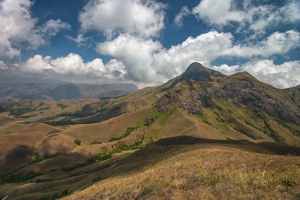
The Western Ghats (पश्चिमी घाट, also called the Sahyadri range in Maharashtra and Karnataka, and the Malai in Tamil), inscribed by UNESCO in 2012, is a mountain range extending 1,600 km along the western coast of peninsular India from the Tapti River in Gujarat in the north to the southern tip of the Kerala-Tamil Nadu border — one of the world’s eight “hottest biodiversity hotspots” as defined by Conservation International (regions with exceptional concentrations of endemic species and that have lost at least 70% of their original habitat, placing them in conservation priority status) and one of the most biologically significant mountain systems on earth, with higher plant diversity than any comparable area in the tropical world outside the Amazon and the Congo Basin. The Western Ghats UNESCO inscription is a serial site comprising 39 designated properties (national parks, wildlife sanctuaries, and reserved forests) across six Indian states (Kerala, Tamil Nadu, Karnataka, Goa, Maharashtra, and Gujarat), covering a total area of approximately 795,315 ha (7,953 km²) out of the total Western Ghats range of approximately 160,000 km² — the UNESCO designation covers only those remnant natural areas that retain sufficient ecological integrity for Outstanding Universal Value assessment, since the broader Western Ghats landscape has been substantially modified by tea, coffee, and rubber plantations, agriculture, and urban development. The range’s highest point is Anamudi (Anamudi Peak, 2,695 m, in Eravikulam National Park in Kerala — the highest peak in peninsular India south of the Himalaya), and the range intercepts the monsoon rainfall from the Arabian Sea to produce the most rainfall in India outside the Meghalaya hills: annual rainfall of 2,000–7,000 mm on the western slopes, creating the “wet zone” forests of Kerala and the Western Ghats that are among the most species-rich forest ecosystems in Asia.
The Western Ghats ecosystems and the heritage landscape of Kerala and Tamil Nadu Eravikulam · Silent Valley · Periyar · Nilgiri Biosphere · Munnar · Ooty — 0 to 250 km
The Western Ghats UNESCO inscription encompasses three distinct ecological zones within the Ghats: (1) the northern Western Ghats (Maharashtra, Goa, and the northern half of Karnataka), characterised by semi-evergreen and moist deciduous forests with a monsoon climate; (2) the southern Western Ghats (southern Karnataka, Kerala, and Tamil Nadu), with the highest biodiversity densities in the range, particularly in the Nilgiri-Anamalai-Palani hills complex (the intersection of the Western Ghats and the Eastern Ghats in the Nilgiri hills, which forms the ecological core of the inscription) and the Kerala lowland wet zone (the most species-rich lowland forest in India); and (3) the Shola-grassland ecosystem (the high-altitude montane grasslands and Shola forest — small patches of dense, stunted evergreen forest in the sheltered valley bottoms separated by exposed montane grassland on the ridges, a specific high-altitude ecosystem above approximately 1,500 m that supports exceptionally high endemism including the Nilgiri tahr, the Shola flycatcher, and numerous endemic plant species). The specific biodiversity numbers for the Western Ghats UNESCO site reflect its status as a biodiversity hotspot: approximately 5,000 species of flowering plants (of which approximately 1,700 are endemic to the Western Ghats), approximately 139 species of mammals (of which approximately 12 are endemic, including the Lion-tailed macaque, the Nilgiri langur, and the Malabar giant squirrel), approximately 508 species of birds (of which 16 are endemic), 179 species of amphibians (of which approximately 65% are endemic — the Western Ghats has the highest amphibian endemism of any region in the world outside Madagascar), and approximately 288 species of freshwater fish (of which approximately 218 are endemic). The specific ecological mechanism that drives this extraordinary endemism is the combination of the topographic isolation of the Western Ghats (the mountain range is separated from the Himalaya by approximately 1,500 km of Deccan plateau, creating a long-isolated evolutionary arena) and the steep gradient from the wet western slope (2,000–7,000 mm annual rainfall) to the dry eastern rain shadow (less than 600 mm in parts of the Deccan), which creates sharply bounded habitat types within a short horizontal distance and promotes speciation in isolated population pockets.
The specific UNESCO-inscribed properties include the major national parks and wildlife sanctuaries of the southern Ghats: Eravikulam National Park (97 km², Kerala, Nilgiri tahr population approximately 800, the largest single protected population of this endemic mountain goat); Silent Valley National Park (89 km², Kerala, one of the last undisturbed lowland evergreen forests in the Indian subcontinent — the subject of a major conservation campaign in the 1970s–1980s that stopped a hydroelectric dam project); Periyar Tiger Reserve (777 km², Kerala, Periyar Lake elephant observation); the Nilgiri Biosphere Reserve (5,500 km², the UNESCO Biosphere Reserve that encompasses several of the inscribed properties in the Nilgiri hills, Mudumalai, Bandipur, Nagarhole, and Wayanad); and Kudremukh National Park (600 km², Karnataka, the core forest area of the northern Kerala-Karnataka border, the source of the Bhadra, Tunga, and Netravathi rivers). The Periyar Tiger Reserve in Kerala (approximately 150 km from Kochi, with the Periyar Lake boat safari as the primary visitor experience) and the Eravikulam National Park (approximately 15 km from Munnar, Kerala) are the most accessible inscribed properties for heritage visitors.
Practical information
The Western Ghats UNESCO serial site is not a single visitable location but a distributed network of protected areas across 1,600 km of mountain range — planning a visit requires selecting specific component properties. The most visitor-accessible inscribed properties are: Eravikulam National Park (15 km from Munnar, Kerala — the Rajamalai area with Nilgiri tahr observation, accessible by bus from Munnar town, open February–June); Periyar Tiger Reserve (Thekkady, Kerala, approximately 150 km from Kochi by road — the Periyar Lake boat safari for elephant observation, open year-round, booking through the Kerala Forest Department); Silent Valley National Park (Kerala, near Palakkad — requires Forest Department permit and guided visit only); Nagarhole National Park (Karnataka, approximately 95 km from Mysuru — jeep safari for tiger, elephant, and leopard, best November–May); and Bandipur Tiger Reserve (Karnataka, adjacent to Nagarhole, approximately 80 km from Mysuru). For the high-altitude Shola ecosystem: the Eravikulam plateau above Munnar (trekking with Forest Department guide), the Nilgiri hills around Ooty (Nilgiri Biosphere Reserve context, accessible from the Nilgiri Mountain Railway — see separate CHO article on Indian Mountain Railways UNESCO). Best visiting months: October–May (post-monsoon, wildlife concentrated near water sources, trails passable); June–September (monsoon — the Western Ghats receive 200–700 mm per month at peak monsoon, making forest access difficult and trails flooded, but the vegetation is spectacular). Kerala and Karnataka have domestic airports at Kochi, Kozhikode, Trivandrum, Bengaluru, and Mangaluru with connections to all Indian cities.
Frequently Asked Questions
Why are the Western Ghats considered one of the world’s biodiversity hotspots and what makes them ecologically unique?
The concept of a “biodiversity hotspot” was defined by the ecologist Norman Myers in 1988 CE in a paper in the journal The Environmentalist, and refined to its current formulation in Myers et al. (2000) in Nature — a region must have at least 1,500 species of endemic vascular plants (species found nowhere else on earth) AND must have lost at least 70% of its original habitat extent to qualify as a hotspot (the second criterion, the habitat loss threshold, reflects the conservation priority logic: endemic species concentrated in rapidly shrinking habitat are at imminent extinction risk, which is different from endemic species in intact habitat). The Western Ghats meets both criteria: it has approximately 1,700 endemic vascular plant species (well above the 1,500 threshold), and the original Western Ghats forest cover has been reduced from approximately 160,000 km² (the estimated natural extent of the moist forest zone) to approximately 40,000 km² of structurally intact forest (approximately 25% of original extent — well below the 30% survival threshold that defines hotspot status). The ecological mechanisms that produced the extraordinary endemism are: (1) The age and continuity of the Western Ghats as a geographical barrier — the Ghats have been a continuous mountain range for approximately 150 million years (since the breakup of Gondwana), providing an extraordinarily long evolutionary isolation period compared to, for example, the Himalaya (which are approximately 40–50 million years old); (2) The monsoon rainfall asymmetry — the western slope receives 2,000–7,000 mm of annual rainfall from the Southwest Monsoon, creating a continuous wet-zone forest that extends from the coastal lowlands to approximately 1,500 m altitude, while the eastern slope is in rain shadow receiving less than 600 mm, creating a sharp ecological gradient within approximately 100 km horizontal distance; (3) The Nilgiri biological corridor — the area where the Western Ghats and Eastern Ghats meet in the Nilgiri hills is the most ecologically significant junction in the range, where the southern Ghats’ high-endemic-density populations are concentrated in a geographic bottleneck that has been identified as the evolutionary epicentre of both the Western Ghats and Eastern Ghats endemism; and (4) The climatic refugia hypothesis — during the Quaternary glacial cycles (when global temperatures were 4–6°C lower and the Indian monsoon was weaker, reducing rainfall), the southwestern tip of India (the Kerala “Agasthyamalai” hills area) is hypothesised to have remained sufficiently wet to maintain continuous forest cover when other parts of the Ghats were dry and stressed — a refugium that preserved species through the glacial cycles and from which re-colonisation occurred when the monsoon recovered. The specific groups with the highest endemism in the Western Ghats are: amphibians (approximately 65% endemism — the highest proportion of any region outside Madagascar), freshwater fish (approximately 76% endemism), and vascular plants (approximately 34% endemism in the inscribed area). The amphibian endemism statistic is particularly striking: new species of frogs are regularly described from the Western Ghats — the Kerala monsoon forests contain so many undescribed amphibian species that systematic surveys typically discover several new species per field season, a rate of new-species discovery unprecedented for such a well-studied region in the non-tropical world. The most dramatic recent example was the description of the Nasikabatrachus sahyadrensis (the “purple frog” or “pig-nosed frog”) in 2003 CE — a living representative of an ancient frog lineage (Nasikabatrachidae) that last shared a common ancestor with its closest relatives (in the Seychelles) approximately 180 million years ago when Gondwana began to break up, making it a living fossil of Gondwanan biogeographic origin that survived in the underground forest ecosystem of the Western Ghats while its relatives became extinct or dispersed across the fragments of the breaking Gondwana supercontinent.
What conservation challenges affect the Western Ghats and how is India managing them?
The Western Ghats face a specific constellation of conservation pressures that reflect their position within one of the most densely populated and economically dynamic agricultural landscapes in Asia: (1) Plantation encroachment — the extensive coverage of the Ghats by tea (concentrated in the Munnar area of Kerala, the Nilgiris in Tamil Nadu, and the Coorg-Chikmagalur area of Karnataka), coffee (the Coorg, Chikmagalur, and Hassan districts of Karnataka are the primary Indian coffee production areas), rubber (Kerala lowland), and cardamom plantations represents the principal historical driver of forest loss in the Ghats; these plantation landscapes replaced moist evergreen forest from the 19th century onward (when British colonial enterprise established the tea and coffee industries in the Ghats) and continue to expand where natural forest remnants remain in private ownership; (2) Infrastructure fragmentation — the multiple road, rail, and power-line corridors that cross the Ghats perpendicular to the range create linear barriers to wildlife movement, particularly affecting the large-mammal corridors (tiger and elephant movement between Karnataka, Kerala, and Tamil Nadu protected areas) that are critical for genetic connectivity between the sub-populations of the inscribed areas; the specific corridors of concern include the National Highway 766 (Kozhikode-Mysuru highway through the Wayanad forest) and the proposed railway line through the Kasargod forest, both of which bisect UNESCO-inscribed areas; (3) Human-wildlife conflict — the proximity of village and agricultural land to the high-density elephant, tiger, and leopard populations of the inscribed areas generates ongoing conflict (crop raiding by elephants, cattle predation by leopards and tigers, occasional human casualties from elephant encounters) that creates local community pressure against conservation and produces retaliatory killings of problem animals; the Western Ghats has the highest density of human-elephant conflict deaths in India; (4) Invasive species — the invasive plant Lantana camara (introduced as an ornamental garden plant in the colonial period) has colonised the forest undergrowth of large areas in the Ghats, reducing native plant diversity and food availability for herbivores; Eucalyptus plantations (established as commercial timber on degraded forest land) have replaced native Shola-grassland ecosystems on ridge areas throughout the Nilgiris and Anaimalais. The Indian policy response to these pressures has evolved through three major instruments: the Gadgil Committee Report (2011, officially the Western Ghats Ecology Expert Panel report, named for the ecologist Madhav Gadgil who chaired it) — which recommended classifying 64% of the Western Ghats area as “Ecologically Sensitive Zones” with development restrictions; the Kasturirangan Committee Report (2013, commissioned after the Gadgil Report’s recommendations were contested as too restrictive for development) — which reduced the ESZ designation to 37% of the area and more narrowly focused restrictions on specific high-biodiversity areas; and the UNESCO World Heritage inscription itself (2012, achieved under the serial-site framework that allowed inscribing only the highest-biodiversity intact forest patches while excluding the plantation and agricultural areas, creating a conservation designation for the 39 inscribed properties that provides some protection against development encroachment). The practical conservation outcome has been mixed: the inscribed properties (the national parks and wildlife sanctuaries) are well-managed and maintain high biodiversity within their boundaries, but the connecting corridors and buffer zones remain contested between conservation priorities and agricultural and infrastructure development pressures, resulting in continued fragmentation of the wildlife movement corridors that are essential for the long-term genetic viability of the protected sub-populations.
EXCERPT: The Western Ghats, UNESCO-inscribed in 2012, is a 1,600 km mountain range along India’s west coast — one of the world’s eight biodiversity hotspots with 1,700 endemic plant species, 65% amphibian endemism (highest outside Madagascar), the 2,695 m Anamudi Peak, and 39 inscribed properties from Kerala’s Silent Valley to Karnataka’s Nagarhole.
META: UNESCO World Heritage Sites near Western Ghats India: Nilgiri Mountain Railway Tamil Nadu (UNESCO 1999–2008, within the Western Ghats), Great Himalayan National Park Himachal Pradesh (comparable biodiversity hotspot) — Western Ghats biodiversity hotspot Kerala Karnataka Tamil Nadu, Eravikulam National Park Nilgiri tahr, Periyar Tiger Reserve Kerala, Silent Valley National Park.
Sources
- S1 — UNESCO World Heritage Centre — Western Ghats (Ref. 1342) — https://web.archive.org/web/20230601000000/https://whc.unesco.org/en/list/1342/
- S2 — UNESCO World Heritage Centre — Statement of Outstanding Universal Value (Ref. 1342) — https://whc.unesco.org/en/list/1342/
Spotted an error? Write to [email protected] and we correct it the same day.