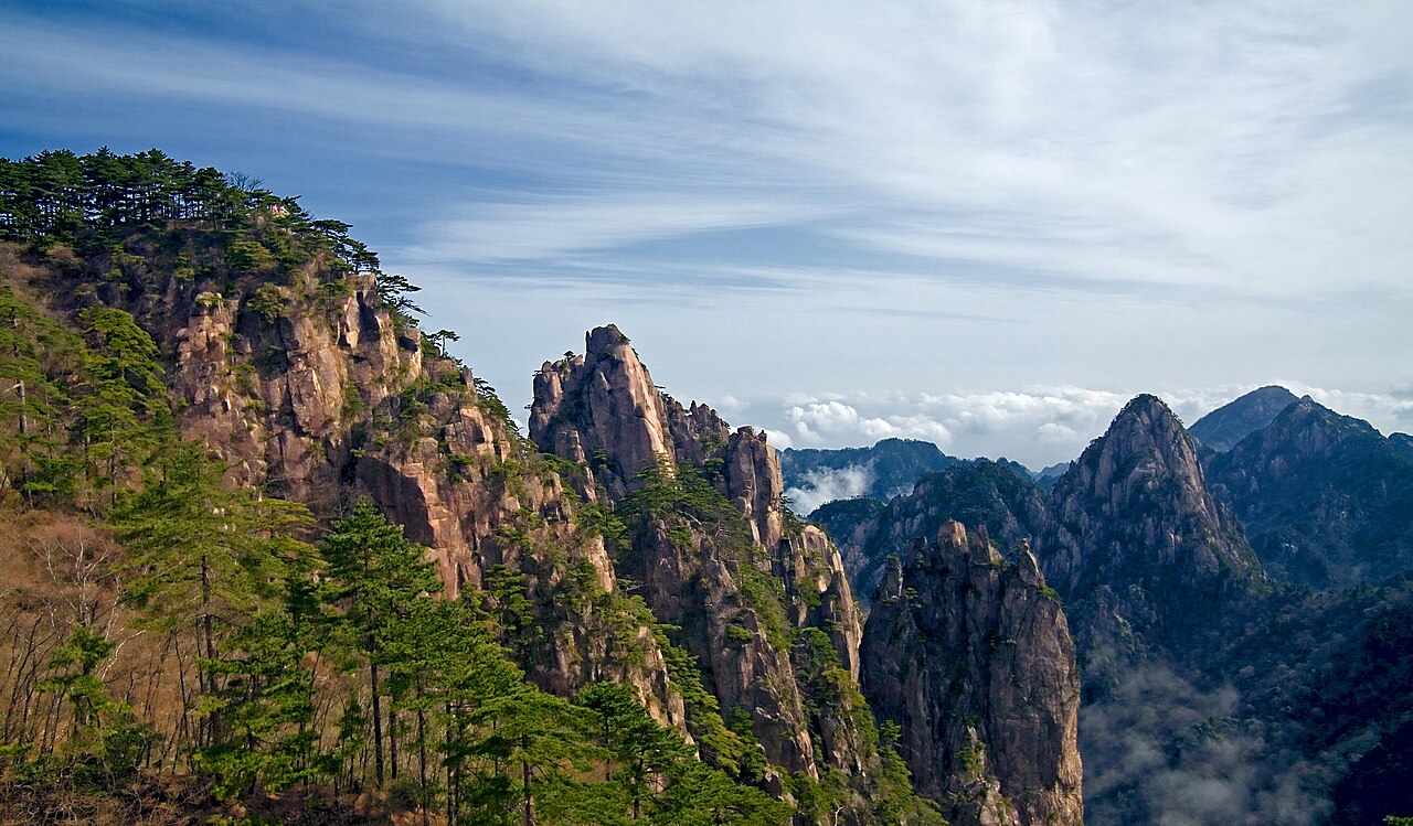
Huangshan (Yellow Mountain), inscribed by UNESCO in 1990 as a mixed cultural and natural World Heritage Site, is a 160-square-kilometre granite mountain complex in southern Anhui Province distinguished by four natural features: cloud seas that fill the valleys between peaks and create a floating-island appearance; peculiarly shaped Huangshan pines (Pinus hwangshanensis) growing in rock crevices at 1,200–1,800 metres altitude; hot springs at the mountain base; and vertical granite pinnacles of unusual stature — 72 peaks above 1,000 metres, the highest at 1,864 metres. The mountain’s visual appearance became the defining image of Chinese landscape painting in the 17th century when the Huangshan school (Hongren, Shitao, Kuncan) redefined Chinese literati art around this specific landscape of cloud-and-granite.
Southern Anhui and the Yangtze valley Xidi and Hongcun · West Lake Hangzhou · Suzhou — 70 to 300 km
Seventy kilometres northeast of Huangshan by bus (approximately 90 minutes from Tangkou, the mountain’s eastern gate town), the Ancient Villages in Southern Anhui — Xidi and Hongcun (inscribed 2000) are the most visited examples of the Huizhou architectural tradition: white-walled, black-tiled merchant houses with carved wooden screens and moon-gate doorways concentrated in two Ming-Qing villages in the hills below Huangshan. The Huizhou merchants — the salt merchants of Yanzhou and Huizhou who controlled the Qing dynasty’s salt monopoly and grew immensely wealthy in the 17th–18th centuries — were the patrons who financed both the intricate woodcarving visible in Xidi’s houses and the publication of the Huangshan painting albums that made the mountain famous across China. Huangshan and Xidi/Hongcun together document the same Huizhou culture at its natural landscape pole (the mountain) and its domestic architectural expression (the villages): both inscriptions are in Anhui Province, both derive from the same cultural and economic geography, and a day’s visit to both sites is a practical itinerary from the Huangshan North HSR station (approximately 40 km from both). The Moon Pond at Hongcun — the semicircular pond at the village’s centre, fed by a channelled stream — is the most photographed element of the inscription, but the complete Xidi courtyard house interiors (several are maintained as house museums) give a better sense of the Huizhou merchant world.
Two hundred fifty kilometres east of Huangshan by high-speed rail (approximately 90 minutes from Huangshan North to Hangzhou South), the West Lake Cultural Landscape of Hangzhou (inscribed 2011) is the urban lake and garden complex at the centre of Hangzhou — a city that Marco Polo called “the greatest city in the world” in the 13th century. West Lake’s 5.6-square-kilometre surface, with its gardens, pagodas, and causeways (including the Su Causeway and Bai Causeway, named after the Song poets-administrators Su Dongpo and Bai Juyi who shaped the lake’s form), documents the idealized landscape aesthetic that the Huangshan painters later expressed in brush and ink. Su Dongpo (Su Shi, 1037–1101 CE), who administered Hangzhou as a Song dynasty governor, wrote the poem “Comparing West Lake to the Beauty Xi Zi” — the first famous literary comparison of West Lake to a beautiful woman — and designed the Su Causeway’s physical form. The same literary-aesthetic tradition that produced Su Dongpo’s West Lake poem produced Hongren’s Huangshan ink paintings in the 17th century; the two inscriptions document the same Jiangnan literati culture at its landscape (Huangshan) and its urban garden (West Lake) poles.
Three hundred kilometres northeast of Huangshan by high-speed rail (approximately 2.5 hours from Huangshan North to Suzhou via Hangzhou or Nanjing), the Classical Gardens of Suzhou (inscribed 1997, 2000) are the most complete surviving examples of Chinese private garden design from the Song to the Qing dynasties. The Suzhou gardens and Huangshan are the two poles of Ming-Qing Chinese aesthetic culture: the mountain as the model of natural verticality and asymmetry that the garden compressed into an urban space of a few hectares. The Suzhou garden designers — retired officials (“humble administrators”) who built private gardens in the 15th–17th centuries — explicitly modelled their rock arrangements (taihu stone, the karst limestone rocks dredged from Lake Tai) on the compressed Huangshan landscape: the crooked scholar rocks in the Master of Nets Garden (Wangshi Yuan) and the Lingering Garden (Liu Yuan) are intended to evoke, in miniature, the Huangshan granite peaks’ verticality and irregular form. The visual argument that a garden rock IS a miniature mountain is the same aesthetic argument that makes Huangshan’s clouds-and-peaks the paradigm of Chinese landscape painting.
Two hundred eighty kilometres south of Huangshan by high-speed rail (approximately 2.5 hours from Huangshan North to Shangrao and bus), the Mount Sanqingshan National Park in Jiangxi Province (inscribed 2008) is a UNESCO natural inscription of the same granite pinnacle landscape type as Huangshan. Sanqingshan’s vertical granite pillars (including the 128-metre “Eastern Huamaster” rock column) emerge from subtropical cloud forest in Jiangxi at similar altitude; the cloud sea, gnarled pines, and precipitous walkways of Sanqingshan are visually similar to Huangshan but less visited and with more intact forest cover. The geological relationship between the two mountains is direct: both are products of the same Yanshanian orogeny (Jurassic-Cretaceous, approximately 140–65 million years ago) that intruded granitic magma through the metamorphic basement of southeastern China, producing the vertical granite landscape visible at both sites. From Huangshan North Station, Sanqingshan requires high-speed rail to Shangrao (approximately 90 minutes) and bus to the park entrance (approximately 40 minutes).
The Yangtze corridor and connections north Nanjing · Wuyishan · South China Karst — 300 to 700 km
Three hundred kilometres northeast of Huangshan by high-speed rail (approximately 2 hours from Huangshan North to Nanjing South), the Imperial Tombs of the Ming and Qing Dynasties at Nanjing — specifically the Xiaoling Mausoleum of the Hongwu Emperor (the Ming founder, added to the inscription in 2003) — are at the Purple Mountain (Zijin Shan) east of Nanjing’s city centre. The Xiaoling is the original Ming imperial tomb, built from 1381 and housing the burial of Zhu Yuanzhang (Hongwu Emperor, died 1398), who founded the Ming dynasty from a base in Nanjing. The Xiaoling’s Spirit Way (an avenue of stone animal sculptures more naturalistically carved than the later Beijing examples) and its walled enclosure represent the Ming burial tradition 30 years before the capital moved to Beijing and the Changling tomb was built. From Nanjing, the Sun Yat-sen Mausoleum (not a UNESCO site but the most visited modern monument in China after Mao’s mausoleum in Beijing) is adjacent to the Xiaoling at Zijin Shan.
Three hundred kilometres southeast of Huangshan by high-speed rail (approximately 2.5 hours from Huangshan North to Wuyishan North), the Mount Wuyi scenic area in Fujian Province (inscribed 1999) is the other major mixed cultural-natural inscription in eastern China. Mount Wuyi’s inscription combines the natural landscape (precipitous red sandstone gorges, the Nine-Bend River, and subtropical forest) with the cultural significance of Wuyi Mountain as the birthplace of Neo-Confucianism: Zhu Xi (1130–1200 CE), the most influential Chinese philosopher since Confucius, taught at Wuyi and developed the Neo-Confucian synthesis of Confucianism, Buddhism, and Daoism that dominated Chinese intellectual life for 700 years. The connection between Huangshan’s landscape aesthetics and Wuyi Mountain’s philosophical tradition is the same Song-dynasty cultural synthesis: the aesthetic contemplation of landscape as a moral and philosophical practice is fundamental to both the Huangshan painting tradition and the Neo-Confucian landscape retreat at Wuyi.
Four hundred kilometres west of Huangshan by high-speed rail (approximately 3 hours via Nanchang to Wuhan), the Three Gorges Cultural Landscape and the Wudang Mountain Ancient Buildings Complex in the Hubei Mountains (inscribed 1994) document the Daoist sacred mountain tradition in central China. The Ancient Building Complex in the Wudang Mountains — 33 temple complexes built from the Tang to the Qing dynasties (600–1900 CE) on a series of precipitous peaks in northwestern Hubei — represents Daoist sacred mountain architecture at its most comprehensive. The martial arts tradition of Wudang (Wudang kung fu and taijiquan), associated with the mountain since the Song dynasty, is the most globally visible aspect of the inscription but is not separately inscribed as intangible heritage; the buildings are the UNESCO focus. From Huangshan North, Wudang Mountain requires high-speed rail to Wuhan (approximately 3 hours) and then to Shiyan (approximately 2 hours), with bus to the mountain.
Seven hundred kilometres west of Huangshan by high-speed rail (approximately 5 hours via Nanchang, Changsha, and Guiyang), the South China Karst UNESCO inscription (2007, extended 2014) covers eight component sites across Guizhou, Yunnan, Guangxi, and Chongqing provinces documenting the world’s most extensive and diverse karst landscape. The South China Karst is geologically and visually distinct from Huangshan’s granite: the karst peaks (fenglin, “forest of peaks”) are dissolved limestone rather than intruded granite, and the visual effect at Yangshuo (the Guilin-Yangshuo fenglin, the most famous component) — individual tapering limestone towers rising from flat valley floors above the Li River — is the visual complement to Huangshan’s clustered granite pinnacle mass. The two landscape types together define the visual range of Chinese scenic mountains: the granite of Huangshan, Sanqingshan, and Lushan on one hand; the limestone karst of South China Karst and Wulingyuan on the other. The Huangshan painting tradition influenced the representation of karst peaks in Chinese art as well: the visual grammar of the vertical pinnacle above cloud is shared between the granite and the karst landscape paintings of the Chinese tradition.
Practical information
Huangshan is reached from Huangshan City (formerly Tunxi), served by Huangshan Tunxi International Airport (flights from Shanghai Hongqiao, approximately 50 minutes; Beijing Capital, approximately 2.5 hours; Guangzhou Baiyun, approximately 2 hours; Hangzhou Xiaoshan, approximately 40 minutes) and by Huangshan North high-speed railway station (on the Hangzhou-Huangshan HSR, opened 2018: Hangzhou South to Huangshan North in approximately 80 minutes; Nanjing South to Huangshan North in approximately 2 hours; Shanghai Hongqiao to Huangshan North in approximately 2.5 hours). From Huangshan City (Tunxi), buses serve the mountain’s eastern (Yuping/Tangkou) and northern (Beihai) access points (approximately 45–60 minutes). Three cable cars serve the mountain: the Yungu cable car to the Beihai area (eastern access, most popular), the Yuping cable car to the Yuping scenic area (southern access), and the Songgu cable car to the western area. The most popular full-day circuit ascends by the Yungu cable car, walks the West Sea Grand Canyon Loop (approximately 4–5 hours), and descends by the Yuping cable car or on foot via the Yuping steps (approximately 2.5 hours). The mountain’s most celebrated viewpoints — Refreshing Terrace (Shiqingfeng), Bright Summit (Guangming Ding, 1,860 m), and Light-Splitting Peak (Paiyun Ting, the classic cloud-sea viewpoint) — are accessible from the Beihai area. Summit hotels (Beihai Hotel, Xihai Hotel) allow overnight stays for sunrise observation above the cloud sea. Peak seasons are May–June and September–October; winter visits (December–February) offer ice and snow on the granite pines and dramatically reduced visitor numbers.
Frequently Asked Questions
Why did Huangshan become China’s most famous painting subject?
Huangshan’s elevation to the central subject of 17th-century Chinese landscape painting was the result of a specific historical moment: the fall of the Ming dynasty to the Qing in 1644 prompted a generation of scholar-artists who refused to serve the new Manchu rulers to retreat to remote areas, and Huangshan’s mountain landscape provided both physical refuge and visual inspiration for a new aesthetic programme. The Huangshan painters — Hongren (1610–1664), Shitao (1642–1707), Kuncan (1612–1673), and Zhu Da (1626–1705) — were all Ming loyalists of various degrees who developed a radical landscape painting style centred on the Huangshan’s specific features: the vertical granite bare-rock faces, the twisted pines in rock crevices, the cloud seas, and the stark mineral quality of the granite in winter. This style contrasted with the lush, rounded, vegetation-covered mountain forms of the Dong-Ju school (the dominant earlier landscape tradition) and proposed instead a landscape of exposed geological structure — stripped of ornament, honest, and morally severe. The aesthetic argument was implicitly political: where the Dong-Ju tradition’s soft-edged mountain aesthetic suited the cultural comfort of the late Ming court, the Huangshan painters’ bare granite expressed a resistance to accommodation. The style proved enormously influential: the 20th-century Chinese artist Qi Baishi credited Shitao as his primary influence, and the visual grammar of the bare-rock pine-and-cloud that Shitao developed at Huangshan is still recognizable in contemporary Chinese ink painting.
What is the Huangshan Pine and why does it grow where other trees cannot?
The Huangshan Pine (Pinus hwangshanensis, Huangshan song) is a species of five-needle pine endemic to the mountain landscape of eastern China (primarily Anhui, Zhejiang, and Jiangxi provinces) at altitudes between 700 and 2,000 metres. Its defining characteristic is the ability to root in bare granite rock cracks with almost no soil: the root system penetrates granite joints and mineral surfaces using both mechanical force (root-growth pressure) and chemical dissolution (root exudate acids that release minerals from the rock surface), extracting nutrients from the rock substrate where no other tree species can survive. The result is the gnarled, asymmetrical pine silhouette — twisted trunk, flattened horizontal crown reaching toward available light — that became the iconic Huangshan visual element reproduced in paintings, porcelain, and tourist imagery. The most famous individual Huangshan pine is the “Greeting Pine” (Ying Ke Song) at the Yuping Scenic Area: a 1,300-year-old specimen on a bare granite ledge at 1,680 metres altitude whose one-sided growth pattern created a dramatic horizontal branch reaching toward the cable car viewpoint — the most photographed tree in China. The Greeting Pine was given an official guardian (a civil servant whose sole duty is to monitor the tree’s health) when it was identified as an irreplaceable cultural symbol; its condition is reported to the Huangshan Management Committee annually. The Huangshan landscape contains approximately 154 individually named and documented ancient pine specimens, each with a traditional name reflecting its form (the “Black Tiger Pine,” the “Dragon Claw Pine,” the “Bonsai Pine”), maintained under the same individual care programme as the Greeting Pine.
How does the UNESCO inscription of Huangshan as a “mixed” site differ from a purely natural or cultural inscription?
UNESCO’s mixed cultural-natural designation (applied to approximately 39 sites globally, including Huangshan) recognizes sites that demonstrate outstanding value under both cultural criteria (representing a human creative work, historical influence, or living cultural tradition) and natural criteria (representing geological processes, biodiversity, natural beauty, or significant evolutionary history). At Huangshan, the cultural criteria derive from the mountain’s role as the central subject of the Huangshan school of Chinese painting — the 17th-century group of Ming loyalist painters whose work transformed Chinese landscape art — and from the historical human landscape of the mountain (temples, inscriptions, and stone paths dating from the Tang dynasty, 618–907 CE, overlaid on the mountain’s geological features). The natural criteria derive from the mountain’s geological significance (the Yanshanian granite batholith exposed by differential erosion to create the pinnacle landscape), its biodiversity (1,452 plant species, 300 vertebrate animal species), and its scenic natural features (the cloud sea, distinctive pines, hot springs, and granite forms). The mixed designation is significant because it prevents the management of the site from treating the cultural and natural values as separate or competing: the Huangshan Management Committee must simultaneously protect the geological features, the forest cover, the ancient pine specimens, the Tang-Qing-era path and temple infrastructure, and the visual landscape that the painting tradition has made globally recognizable. Mixed sites are generally more complex to manage than purely natural or purely cultural sites because they require simultaneous compliance with both sets of UNESCO Outstanding Universal Value criteria.
Sources
- S1 — UNESCO World Heritage Centre — Mount Huangshan (Ref. 547) — https://web.archive.org/web/20230601000000/https://whc.unesco.org/en/list/547/
- S2 — UNESCO World Heritage Centre — Statement of Outstanding Universal Value (Ref. 547) — https://whc.unesco.org/en/list/547/
Spotted an error? Write to editorial@culturalheritageonline.com and we correct it the same day.