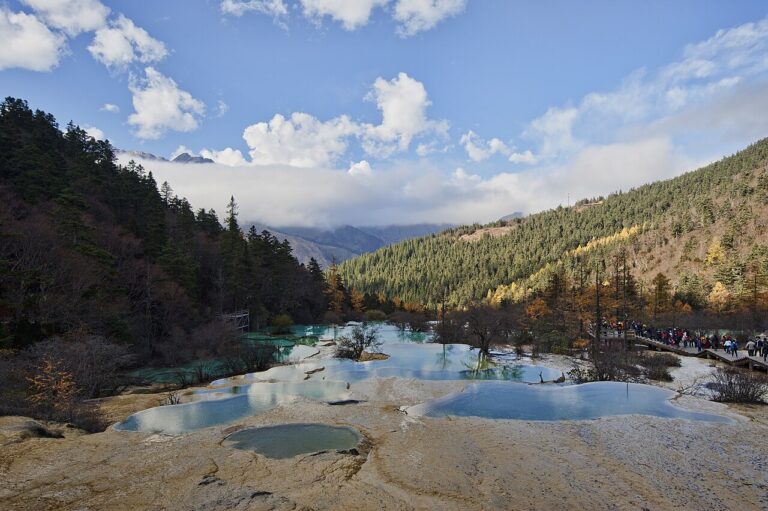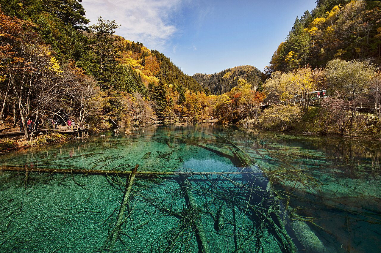
Jiuzhaigou Valley, inscribed by UNESCO in 1992 as a natural World Heritage Site, is a 72,000-hectare mountain valley in Ngawa Tibetan and Qiang Autonomous Prefecture, Sichuan Province, distinguished by 114 travertine lakes of exceptional colour — aquamarine, turquoise, and emerald — produced by calcium carbonate precipitation from the valley’s spring and river waters interacting with algae and bacteria. The valley sits at 2,000–3,100 metres altitude in the eastern Min Mountains, a branch of the Qinghai-Tibet Plateau’s eastern margin, and includes seasonal travertine waterfalls (including Nuorilang at 320 metres wide and 24.5 metres high, the widest high-altitude waterfall in China), dense coniferous and broadleaf forest, and the seasonal colour changes of its alpine lake system.
Southern Sichuan UNESCO corridor Huanglong · Dujiangyan · Mount Emei — 56 to 340 km
Fifty-six kilometres southeast of Jiuzhaigou by road (approximately 2 hours on the mountain highway via Songpan County), the Huanglong Scenic and Historic Interest Area (inscribed 1992) is the other Sichuan UNESCO natural inscription from the same year: a 7.5-kilometre glacially carved valley at 3,180–4,995 metres altitude containing approximately 3,400 travertine terraced pools of deep gold, blue, and green colours produced by the highest calcite concentration of any known travertine spring system. Jiuzhaigou’s lakes derive their colour from suspended calcium carbonate and algae in relatively shallow water; Huanglong’s pools derive their distinctive gold colour from a higher concentration of calcite deposits on the terrace floors. The two inscriptions document the same Min Mountain geological system at two elevations and two landscape typologies (valley lake system at Jiuzhaigou; mountain-stream terrace system at Huanglong) in the same inscription year. The Jiuzhai-Huanglong Airport (JZH), located between the two inscriptions at 3,448 metres altitude (the highest commercial airport in China), serves direct flights from Chengdu, Beijing, Shanghai, and Xi’an, making the two-inscription circuit practical as a single itinerary.
Two hundred fifty kilometres south of Jiuzhaigou by road (approximately 3.5 hours via Chengdu), the Mount Qingcheng and the Dujiangyan Irrigation System (inscribed 2000) comprises two adjacent components in the Chengdu metropolitan area: Dujiangyan City’s hydraulic engineering complex (built 256 BCE by Qin engineer Li Bing, continuously operating for 2,275 years and still irrigating 1.3 million hectares of the Chengdu Plain) and Mount Qingcheng (one of the birthplaces of Taoism in China, with temple complexes from the Han through Qing dynasties). The Dujiangyan system divides the Min River using three water management structures (Fish Mouth diversion dike, Feishayan spillway, Baopingkou water inlet) without a dam: the same river whose headwaters feed the Min Mountain springs that produce Jiuzhaigou’s lakes flows 250 kilometres south to the Chengdu Plain through the irrigation system. From Jiuzhaigou, Chengdu is reached by road (approximately 5 hours via Chengdu-Mianyang Expressway) or by air (Jiuzhai-Huanglong Airport to Chengdu Tianfu, approximately 35 minutes).
Three hundred forty kilometres south of Jiuzhaigou by road via Chengdu (approximately 5 hours by road or 3.5 hours by road from Chengdu South), the Mount Emei Scenic Area and the Leshan Giant Buddha Scenic Area (inscribed 1996) document two aspects of Sichuan’s Buddhist sacred mountain tradition: Mount Emei (3,099 metres), one of the Four Sacred Buddhist Mountains of China, with monastery complexes from the 16th–20th centuries; and the Leshan Giant Buddha, the 71-metre seated stone figure of Maitreya Buddha carved from the Lingyun cliff face at the confluence of the Min, Dadu, and Qingyi rivers between 713 and 803 CE, the tallest pre-modern stone Buddha in the world. The Leshan Buddha’s construction required 90 years and was directed at calming the currents at the rivers’ confluence that regularly capsized boats carrying pilgrims to Mount Emei. From Chengdu, Mount Emei and Leshan are reached by high-speed rail on the Chengdu-Kunming HSR (approximately 90 minutes from Chengdu East to Emeishan Station).
Two hundred kilometres south of Jiuzhaigou by road (approximately 3 hours via Maerkang), the Sichuan Giant Panda Sanctuaries — Wolong, Mt Siguniang, and Jiajin Mountains (inscribed 2006) cover 924,500 hectares of mountain habitat in six nature reserves and nine scenic parks in Sichuan’s western mountains. The inscription protects more than 30 percent of the world’s wild giant panda (Ailuropoda melanoleuca) population in the Min and Qionglai mountain ranges adjacent to Jiuzhaigou’s own Min Mountain system. The Wolong Nature Reserve, established 1963 and the oldest giant panda reserve in China, is the primary component; the Panda Research Base at Wolong (separate from the better-known Chengdu Research Base of Giant Panda Breeding, which is not a UNESCO site) is accessible for visitors. From Jiuzhaigou, the Qianlong Tibetan architecture and the Wolong pandas are reachable in the same multi-day circuit via road through the Min Mountains.
High-altitude rail connections west and northwest Jiuzhai-Huanglong Airport · Chengdu-Lhasa corridor · Yunnan — 500 to 1,500 km
One thousand kilometres southwest of Jiuzhaigou (accessible by air from Jiuzhai-Huanglong Airport to Chengdu, then Chengdu to Kunming, approximately 1.5 hours total, then bus or rail), the Three Parallel Rivers of Yunnan Protected Areas (inscribed 2003) is the UNESCO inscription for one of the most biodiverse regions on Earth: 1.7 million hectares in northwestern Yunnan where the Salween (Nu), Mekong (Lancang), and Yangtze (Jinsha) rivers run parallel through gorges cut 3,000 metres deep in the Hengduan Mountains within a corridor 60–70 kilometres wide. The Three Parallel Rivers inscription and the Jiuzhaigou inscription are at opposite ends of the same Hengduan Mountain system: Jiuzhaigou’s Min Mountains are the northeastern margin of the Hengduan range; the Three Parallel Rivers gorges are the western and southern interior. The combined altitude range of the two inscriptions (from Jiuzhaigou’s valley floor at 2,000 metres to the Three Parallel Rivers’ Meili Snow Mountain at 6,740 metres) documents the full elevation gradient of the Hengduan system.
One thousand five hundred kilometres north of Jiuzhaigou (by air from Jiuzhai-Huanglong Airport to Lanzhou, then bus or rail to the Jiayuguan-Dunhuang corridor, approximately 4 hours total), the Mogao Caves at Dunhuang (inscribed 1987) are the farthest connected inscription on the Silk Road system that the Min Mountain plateau geography divides from the eastern Chinese lowland circuit. The agricultural population of the Chengdu Plain that the Dujiangyan irrigation system sustained from 256 BCE was the western anchor of the Han dynasty’s administration of the territories connecting the Silk Road: the political-economic system centred on Chengdu that the Min River’s irrigation made possible was the production base that financed the Han military expansion into the Hexi Corridor through which the Silk Road ran. The Jiuzhaigou landscape — above the tree line at 3,100 metres, seasonally inaccessible, beyond the traditional Chinese agricultural frontier — was the visual opposite of the Chengdu Plain’s productive lowland: two faces of the same Sichuan geography.
One thousand two hundred kilometres southwest of Jiuzhaigou by air (Jiuzhai-Huanglong Airport to Chengdu, then Chengdu to Lhasa Gonggar Airport, approximately 2 hours total), the Historic Ensemble of the Potala Palace in Lhasa (inscribed 1994, extended 2000, 2001) documents the Tibetan Buddhist political and religious capital at the centre of the Tibetan Plateau. The Potala Palace complex — including the Red Palace (Karmar) atop the Marpo Ri hill (3,700 metres) with the Dalai Lamas’ winter residence (the White Palace, Potrang Karpo) and the tomb chambers of eight Dalai Lamas — stands 340 kilometres north of the Chengdu-Lhasa air corridor’s midpoint, above which the Min Mountain system where Jiuzhaigou sits is visible on clear days from the aircraft. The Ngawa Prefecture where Jiuzhaigou is located is ethnically and culturally Tibetan, administered as an autonomous prefecture within Sichuan since 1953; the landscape, monastery architecture, and nomadic pastoralist traditions of Ngawa are continuous with the Tibetan cultural world documented in the Lhasa inscription.
Eight hundred kilometres east of Jiuzhaigou by road and high-speed rail (approximately 6 hours via Chengdu to Wuhan, then 1.5 hours to Wulingyuan/Zhangjiajie), the Wulingyuan Scenic and Historic Interest Area (inscribed 1992) in Hunan Province documents the landscape of quartzite sandstone pillars and gorges that is visually opposite to Jiuzhaigou’s lake system. Where Jiuzhaigou is a horizontal landscape of still water surfaces in a forested valley, Wulingyuan is a vertical landscape of isolated rock columns rising 200–400 metres above the valley floor. Both were inscribed by UNESCO in 1992 as natural sites; both were proposed in China’s first major wave of UNESCO natural nominations, representing the two dominant landscape types of China’s mountain interior: the river-lake geography of the plateau margins and the sandstone column landscape of the Yangtze tributaries.
Practical information
Jiuzhaigou Valley is located 340 kilometres north of Chengdu by road (approximately 5–6 hours via the Chengdu-Jiuzhaigou Expressway) and served by the Jiuzhai-Huanglong Airport (JZH) at 3,448 metres altitude, 88 kilometres from the park entrance. The airport operates flights from Chengdu Tianfu (approximately 35 minutes), Beijing Capital (approximately 2.5 hours), Shanghai Pudong (approximately 3 hours), Guangzhou Baiyun (approximately 2.5 hours), and Xi’an Xianyang (approximately 1.5 hours). High winds and mountain weather frequently cause flight delays or cancellations; carry-on-only luggage and flexible scheduling are advised. From the airport, shuttle buses and taxis serve the Zhangzha Gou tourist zone (approximately 1.5 hours). The park’s entrance is at Shuzheng Village (2,010 metres); internal transport is by park shuttle bus on a one-way road system (visitors ride up by bus and walk down, or vice versa). The valley is divided into three scenic routes — Shuzheng Valley, Rize Valley (leading to the Long Lake at 3,102 metres), and Zechawa Valley (leading to the Five-Colour Lake) — requiring two full days for complete coverage. The park was severely damaged by the Jiuzhaigou earthquake of 8 August 2017 (magnitude 7.0), which triggered rockslides that altered several lakes and closed the park for reconstruction; phased reopening began in 2019 with a daily visitor cap of 15,000 (previously 45,000 pre-earthquake). The optimal visiting seasons are September–November (autumn foliage, highest colour contrast in the lakes) and May–June (highest water flow in the waterfalls); July–August is peak tourist season with longer queues. Winter (December–February) offers the frozen waterfall spectacle but limited lake visibility and some trail closures.
Frequently Asked Questions
Why are Jiuzhaigou’s lakes so many different colours?
Jiuzhaigou’s 114 lakes display colours ranging from deep turquoise to pale jade to translucent emerald, with individual lakes varying from milky white to brilliant blue-green to near-black. The colour variation has three primary causes. First, water depth: shallower lakes (under 1 metre) appear pale and whitish because the calcium carbonate precipitate is visible on the lake floor; medium-depth lakes (1–5 metres) appear jade green because light penetrates to the calcium carbonate bottom and reflects with the algae covering; the deepest lakes (above 10 metres, including the Long Lake at 40 metres deep) appear deep blue to dark teal because only short wavelengths penetrate to visible depth. Second, algae and bacteria: the travertine lake system supports a dense community of calcareous algae (primarily cyanobacteria and green algae) whose photosynthetic pigments interact with the calcium carbonate substrate and the water column to produce the characteristic colours, which change with season as algal communities shift in response to temperature and light. Third, fallen logs and submerged trees: the most distinctive lakes — including Five Flower Lake (Wuhuahai), the most photographed — contain hundreds of ancient logs submerged on the travertine floor that are preserved in the calcite-saturated water almost without decay, visible through the clear water as a layer of structured texture beneath the colour surface. The combination of calcium-carbonate-saturated spring water, algal community succession, the seasonal cycle of snowmelt (which dilutes the calcite concentration and shifts colours toward blue), and the fallen log substructure creates a system where no two lakes look the same and the same lake looks different in different months.
What caused the 2017 earthquake and what happened to the park?
The 8 August 2017 Jiuzhaigou earthquake (magnitude 7.0 on the Richter scale) occurred at a depth of 20 kilometres on the Minjiang-Bailong fault zone, a northeast-trending active fault system running through the eastern Tibetan Plateau margin in which the Min Mountains are located. The same fault system produced the 2008 Wenchuan earthquake (magnitude 7.9, approximately 100 kilometres south of Jiuzhaigou) that killed approximately 87,000 people; the 2017 event killed 25 people (mostly tourists in the park), with the lower toll partly attributable to the park’s lower population density compared to the Wenchuan area. Within the park, the earthquake triggered more than 500 rock falls, mudflows, and landslides. The most significant hydrological damage: Spark Lake (Huohuahai) lost most of its water through fractures in the travertine dam; the travertine barriers of several other lakes cracked and water levels dropped. Nuorilang Waterfall — the park’s most famous waterfall — partially collapsed, and the tourist boardwalk over the travertine falls was destroyed. The Chinese government launched a major park reconstruction, including structural repair of damaged travertine barriers (a process requiring pumping calcium-carbonate-saturated water over the breach sections to allow natural calcite deposition to rebuild the barrier, which takes years), rebuilding the boardwalk infrastructure, and stabilising the rockfall zones. By 2023, approximately 80 percent of the pre-earthquake scenic spots were accessible to visitors, though the daily cap of 15,000 visitors (down from the pre-earthquake 45,000) reflects both the reduced infrastructure capacity and a deliberate policy of reducing visitor impact to allow natural travertine recovery.
What is the cultural significance of Jiuzhaigou for the Tibetan and Qiang communities who live there?
The name Jiuzhaigou means “Nine Village Valley” in Chinese, referring to the nine Tibetan villages — Shuzheng, Heye, Zechawa, Nuorilang, Rize, Aga, Jianpan, Panya, and Yala — that were established in the valley by Tibetan-speaking communities, part of the Tibetan ethnic group’s eastern distribution in the Ngawa Tibetan and Qiang Autonomous Prefecture. Prior to the park’s establishment in 1978 and its UNESCO inscription in 1992, the valley communities sustained themselves by logging (which was one cause of the landscape degradation that prompted the park designation) and subsistence agriculture and pastoralism at lower altitudes. The park’s UNESCO inscription created a significant income transformation for the resident communities: as of the early 2000s, approximately 1,000 Tibetan residents were employed in park services (tour guiding, hospitality, shuttle bus operation), with additional households running guesthouses and restaurants in the Zhangzha Gou tourist village outside the park entrance. The Tibetan Buddhist sacred geography of the valley includes prayer flags at mountain passes, mani stone walls along paths, and the Zha Yi Zha Ga Mountain (4,558 metres) identified as a protective deity mountain in local religious tradition. The UNESCO inscription recognized the valley’s natural values exclusively (the inscription criteria are natural, not cultural); the resident community’s management rights, the traditional land-use boundaries of the nine villages, and the religious significance of specific natural features (certain lakes and peaks considered sacred and not to be approached) are negotiated separately in the park management agreement between the Ngawa Prefecture government and the resident communities.
Sources
- S1 — UNESCO World Heritage Centre — Jiuzhaigou Valley Scenic and Historic Interest Area (Ref. 637) — https://web.archive.org/web/20230601000000/https://whc.unesco.org/en/list/637/
- S2 — UNESCO World Heritage Centre — Statement of Outstanding Universal Value (Ref. 637) — https://whc.unesco.org/en/list/637/
Spotted an error? Write to editorial@culturalheritageonline.com and we correct it the same day.