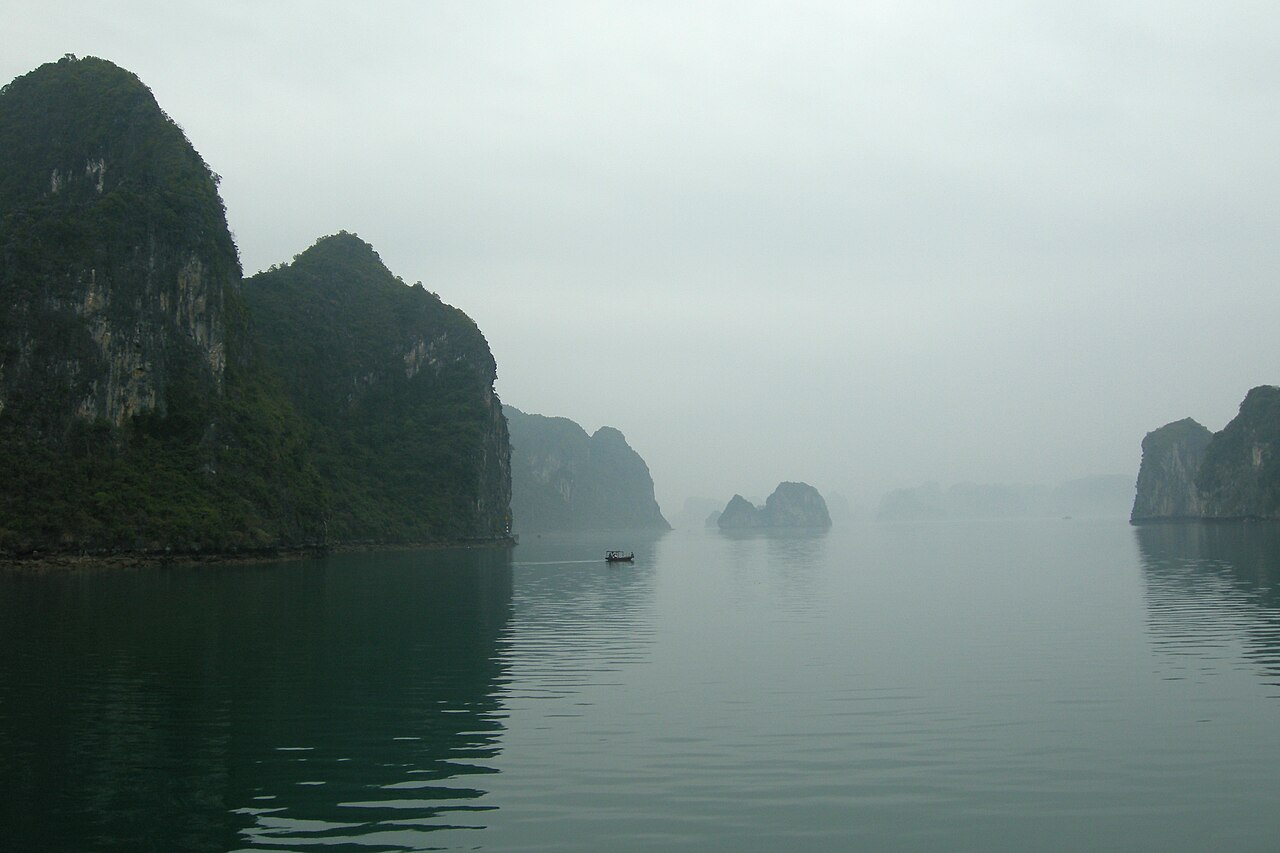
Ha Long Bay (Vịnh Hạ Long, “Bay of the Descending Dragon”), inscribed by UNESCO in 1994 and extended to include the adjacent Bai Tu Long Bay in 2000, is a coastal karst landscape in Quảng Ninh Province, northeastern Vietnam — an approximately 1,553 km² area of the Gulf of Tonkin (extended area: 1,969 km²) containing 1,969 limestone and dolomite islands rising vertically from the sea at heights between 5 and 200 m, formed by the differential erosion of a carbonate bedrock platform that originally formed as a coral reef in the shallow warm sea covering the region approximately 500 million years ago, was uplifted by tectonic forces approximately 250–280 million years ago, and has been progressively dissolved and shaped by acidic rainwater over the past 20 million years into the characteristic tower karst (fenglin) and cone karst (fengcong) landscape visible today. The inscription’s Outstanding Universal Value rests on the exceptional aesthetic quality of the seascape — 1,969 islands of varying heights, shapes, and colours (from the mist-covered silhouettes of distant islands at dawn to the bright orange limestone cliffs in afternoon light, the emerald-green water between them shifting in colour with depth, cloud cover, and season), combined with the scientific value of the karst geomorphology (the Ha Long Bay karst is one of the finest examples in the world of a tropical marine fenglin karst, a category of karst formation produced by the interaction of terrestrial karst dissolution with rising sea levels) and the presence of at least two inhabited floating villages (làng chài nổi, floating fishing communities, the most famous at Cửa Vạn and Vung Viêng, inhabited year-round by the descendants of several-generation fishing families who maintain traditional boat-building, fish-farming, and pearl-cultivation practices on the water).
Ha Long Bay’s island and cave circuit and the regional heritage context Sung Sot Cave · Tuan Chau island · Cat Ba Island National Park — 4 to 20 km
The most visited single attraction within the Ha Long Bay inscription area is Sung Sot Cave (Hang Sửng Sốt, “Cave of Surprises”, on Bò Hòn Island, approximately 14 km from the main Ha Long City ferry terminal by cruise boat, accessible only by organised boat tour since private motorboat landing on the islands is restricted by the management authority). Sung Sot is the largest of Ha Long Bay’s approximately 250 caves and grottoes — a two-chamber cave system with the outer chamber approximately 10,000 m² in floor area and 30 m in height, and the inner chamber approximately 12,000 m², both richly decorated with stalactites, stalagmites, and flowstone curtains illuminated by coloured lighting for visitor effect (controversial among natural heritage conservationists, who argue that the non-natural lighting changes visitor perception of the cave’s geological character, but supported by the bay management authority as necessary for visitor appreciation). The cave was named for the exclamation of surprise reportedly made by the French explorer who first entered it in the early 20th century. Thiên Cung Cave (Hang Thiên Cung, “Heavenly Palace Cave”, approximately 4 km from the Ha Long City pier on Đầu Gỗ Island) is the most elaborately decorated cave in Ha Long Bay, with stalactites in forms resembling dragons, phoenixes, and cloud formations that are named according to Vietnamese folk mythology — the cave is integrated into an island interior that provides a rare experience of entering a karst feature from the sea rather than from a hillside entrance. Cat Ba Island National Park (Vườn Quốc gia Cát Bà, on Cat Ba Island, the largest island in Ha Long Bay at approximately 354 km², partially included in the UNESCO inscription’s extended area), approximately 20 km from Ha Long City by fast boat (approximately 45 minutes), provides the most diverse terrestrial ecology within the inscription — including the primary habitat of the critically endangered Cat Ba langur (Trachypithecus poliocephalus, IUCN Critically Endangered, global population approximately 70 individuals, one of the rarest primates in the world, restricted entirely to the Cat Ba Island limestone forest).
Ha Long City (Thành phố Hạ Long, the gateway city for the bay, approximately 180 km east of Hanoi by road or 3.5 hours by bus, accessible by daily flights from Hanoi Nội Bài Airport to Van Don International Airport and then 30 minutes by road) is the primary embarkation point for the overnight and multi-day cruise boats that are the dominant format for visiting Ha Long Bay. The overnight cruise format — departing late morning, visiting caves and islands during the afternoon and next morning, returning to Ha Long City by noon on day two — is the established visitor experience and is offered by approximately 500 licensed cruise operators ranging from budget dormitory junks to luxury colonial-style wooden vessels. Day trips to Ha Long Bay from Hanoi (approximately 7 hours including round-trip road transfer and 4 hours on the water) are possible but provide an abbreviated experience. The adjacent Bai Tu Long Bay (Vịnh Bái Tử Long, included in the 2000 extension of the UNESCO inscription, north of Ha Long Bay, accessible from Vân Đồn District) is significantly less visited than Ha Long Bay proper, with fewer cruise operators but less crowded conditions and better preserved traditional floating fishing village communities — recommended for visitors seeking a quieter experience of the karst landscape. Ninh Bình Province’s Tràng An Landscape Complex (inscribed UNESCO 2014, approximately 160 km south of Ha Long City by road) provides an inland river-cave karst experience that is geologically related to (and geographically continuous with) the Ha Long Bay landscape — the same carbonate bedrock platform extends inland across northern Vietnam, producing the Tràng An river caves and the Tam Cốc rice-field valley as the terrestrial equivalent of Ha Long Bay’s marine karst.
Practical information
Ha Long Bay is visited almost exclusively by organised boat tours: private visitor access to the islands is restricted by the UNESCO management authority (Quảng Ninh Province), and the bay’s cave and grotto experiences require boat transport from Ha Long City or Cat Ba Island. The choice of boat tour is the primary practical decision for Ha Long Bay visitors: day cruises (depart 08:00, return 18:00, visiting 2–3 caves and 1–2 islands, approximately USD 50–80 per person) provide the basic cave and island experience; overnight cruises (depart 12:00, return 12:00 next day, including 2 nights on the boat for 3-day tours, meals included, kakayking excursion, floating village visit, approximately USD 100–250 per person for 2-day/1-night) are the recommended format for a meaningful experience of the bay’s scale and dawn/dusk light quality; 3-day cruises reach the more remote areas of Bai Tu Long Bay. Booking with a reputable operator through a Hanoi hotel or tour agency is strongly recommended over booking directly at the Ha Long City pier, where less reputable operators target walk-up customers with substandard boats and misrepresented itineraries. The busiest months are March–May and September–November (the recommended visiting seasons for clear air and moderate temperature, 20–28°C); July–August has the highest tourist volume but also the highest chance of weather disruption from typhoons; December–February brings cool, mist-laden conditions (10–15°C) that can produce the most dramatic photographic light quality but with the risk of days with low visibility. The Ha Long Bay Management Authority strictly regulates environmental practices: plastic waste management on cruise boats is required by regulation, but enforcement is uneven — choosing operators with visible environmental policies and recycling programmes reduces the visitor’s contribution to the bay’s significant plastic waste problem.
Frequently Asked Questions
How did the Ha Long Bay karst landscape form over geological time?
The Ha Long Bay karst landscape represents approximately 500 million years of geological history, from the original carbonate sediment deposition in a warm shallow sea, through tectonic uplift, subaerial erosion, and marine transgression, to the present seascape of 1,969 vertical islands. The carbonate bedrock (primarily limestone, with some dolomite) that forms the Ha Long Bay islands was deposited approximately 500–300 million years ago (Ordovician to Permian periods) as accumulations of calcareous marine organisms (coral, bryozoa, crinoids, and microorganic lime muds) in a warm shallow sea covering the South China block — the geological province that now encompasses southern China and northern Vietnam. This carbonate platform was uplifted by the tectonic collision of the Indo-Australian and Eurasian plates (the same collision that produced the Himalayas further west) approximately 250–280 million years ago, bringing the limestone above sea level and exposing it to rainfall-driven dissolution. Limestone is soluble in the slightly acidic rainwater created when atmospheric CO₂ dissolves in precipitation (producing dilute carbonic acid), and the dissolution proceeds along the limestone’s natural joint and fracture systems — the vertical fractures in the Ha Long Bay limestone (produced by the original tectonic stresses) controlled the direction of dissolution, producing the vertical towers and pinnacles rather than the rounded hills that form in granite or sandstone. The current seascape developed in two stages: the towers and valley systems were carved during the Late Tertiary and Quaternary periods (approximately 20 million to 10,000 years ago) when sea level was lower than today and the Ha Long Bay area was a terrestrial karst landscape of towers separated by river valleys; when sea level rose approximately 10,000 years ago at the end of the last glacial period (sea level has risen approximately 120 m globally since the Last Glacial Maximum), the river valleys were inundated, leaving the tower summits as the islands visible today. The bay’s current sea level is close to the maximum of the current interglacial period — geologists expect that continued sea level rise (driven by climate change-induced glacier melt) will progressively inundate more of the island base areas, changing the Ha Long Bay landscape on a timescale of decades to centuries.
Who are the floating village communities of Ha Long Bay and what is their future?
The floating villages (làng chài nổi, “floating fishing villages”) of Ha Long Bay are communities of families who live year-round on wooden boats and floating house platforms moored to the limestone cliffs or anchored in sheltered bays within the inscription area — the most famous communities at Cửa Vạn (approximately 800 people in the late 1990s, now significantly reduced), Vung Viêng, Ba Hang, and Cống Đầm. The communities’ presence on the water is documented from at least the 17th century CE (appearing in the records of Vietnamese imperial officials dispatched to Quảng Ninh Province), though the extent to which the current communities are descended from the historical water-dwelling populations or represent more recent migrations to a marine resource-rich area is debated by Vietnamese historians. The floating community lifestyle involves boat-based fishing (using traditional bamboo fish traps, drift nets, and line fishing), fish cultivation (floating cages housing grouper, sea bass, and carp), pearl mussel farming, and more recently tourism-related activities (selling handicrafts and food to passing cruise boats, operating traditional sampan tours through the floating village lanes). The future of the floating village communities is the central management controversy of the Ha Long Bay UNESCO site: the Quảng Ninh Province government has pursued a policy of relocating floating village residents to onshore housing estates (citing concerns about child education access, healthcare access, and water quality management), with the Cửa Vạn community substantially relocated to Hùng Thắng onshore housing in 2014 and subsequent years. UNESCO and ICOMOS have raised questions about the relocation policy’s impact on the cultural heritage value of the floating villages, which the nomination documentation identified as part of the inscription’s Outstanding Universal Value — specifically the living tradition of human adaptation to the karst seascape. The remaining floating communities in Vung Viêng and other locations now receive organised tourist visits as part of cruise itineraries, creating a paradox in which the relocation policy is simultaneously destroying the communities and commercialising their reduced remnants.
What are the main environmental threats to Ha Long Bay’s UNESCO inscription?
Ha Long Bay’s UNESCO inscription is subject to ongoing environmental threat that the UNESCO World Heritage Committee has repeatedly noted in its periodic monitoring reports — a combination of tourism pressure, industrial pollution, aquaculture degradation, and governance challenges that make Ha Long one of the most actively threatened natural World Heritage sites in Asia. Tourism volume is the most immediately visible threat: the bay received approximately 4–5 million visitors per year before the COVID-19 pandemic (2020–2022 decline), with approximately 500 licensed overnight cruise boats operating simultaneously on busy nights — a density that produces significant underwater noise disturbance, diesel exhaust, waste water discharge (regulations require waste tanks on all licensed boats, but compliance monitoring is acknowledged to be incomplete), and wave erosion from boat traffic at the bases of the limestone islands. Coal industry impact is the second major threat: Quảng Ninh Province is the largest coal-producing province in Vietnam, and the coal export port of Hòn Gai (within Ha Long City, adjacent to the inscription boundary) processes millions of tonnes of coal annually — coal dust and ship bilge discharges have been detected in water quality monitoring within the inscription boundary, and the planned expansion of the coal export facility in 2019 was the subject of a UNESCO warning letter requesting an environmental impact assessment before construction proceeded. Aquaculture has transformed the water quality in several parts of the bay: fish and shellfish cages (numbering in the tens of thousands in the 1990s and 2000s) discharged organic waste at concentrations that caused localised dead zones and algal blooms; the Quảng Ninh government partially relocated aquaculture operations outside the inscription boundary in 2015, but monitoring data suggests residual water quality impacts persist. The UNESCO Reactive Monitoring Mission of 2012 and subsequent periodic reporting have consistently noted that the institutional capacity of the Ha Long Bay Management Authority (underfunded relative to the management challenges, with regulatory authority shared between multiple provincial and national agencies) is insufficient to address the cumulative threats from tourism, industry, and aquaculture simultaneously.
Sources
- S1 — UNESCO World Heritage Centre — Ha Long Bay – Cat Ba Archipelago (Ref. 672) — https://web.archive.org/web/20230601000000/https://whc.unesco.org/en/list/672/
- S2 — UNESCO World Heritage Centre — Statement of Outstanding Universal Value (Ref. 672) — https://whc.unesco.org/en/list/672/
Spotted an error? Write to editorial@culturalheritageonline.com and we correct it the same day.