
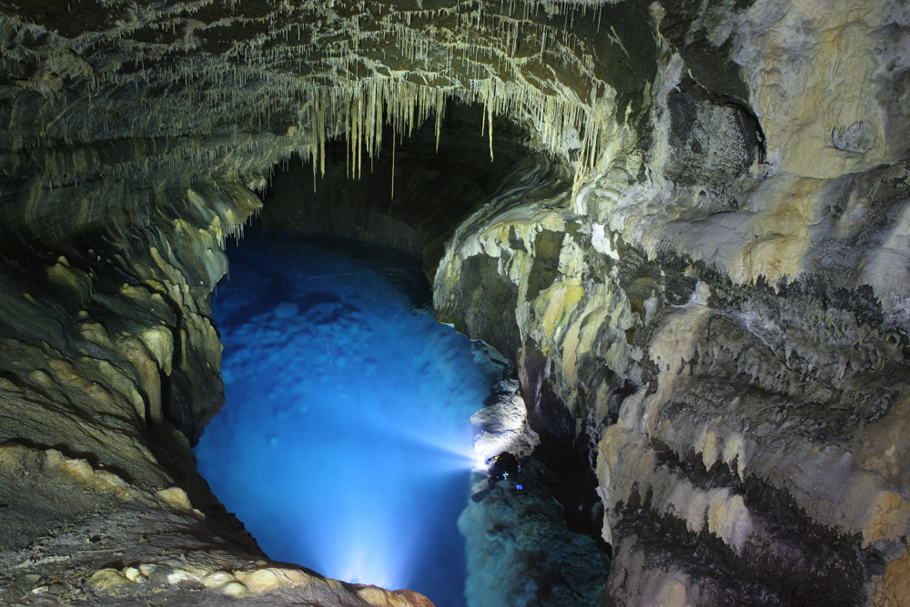
Jeju Island, the largest island of South Korea at 1,849 km², sits 85 kilometres off the southern tip of the Korean peninsula and holds one of the country’s first natural UNESCO World Heritage inscriptions, awarded in 2007. The inscription covers three separate components: Hallasan National Park, the Geomunoreum Lava Tube System, and the Seongsan Ilchulbong Tuff Cone — each representing a different chapter of the island’s volcanic formation, which began approximately 1.2 million years ago. Together they document a type of volcanic geology rare anywhere on earth, including a network of basalt caves where calcium carbonate stalactites have formed on lava walls — a combination that contradicts what most geologists expect to find underground.
Hallasan: a Shield Volcano With 360 Craters and a Lake at 1,850 Metres Jeju Island, South Korea
Hallasan is not a dramatic, steep-sided stratovolcano in the mould of Vesuvius or Fuji. It is a shield volcano — low, broad, and built from successive layers of fluid basaltic lava that spread outward rather than piling upward. The summit reaches 1,950 metres, making it the highest peak in South Korea, and the crater at the top (Baengnokdam) holds a crater lake at approximately 1,850 metres. The lake is roughly 550 metres across and varies in depth between seasons. Its surface reflects the sky at the summit in a way that has made it a reference point in Korean poetry for centuries.
The volcanic activity that built Jeju began approximately 1.2 million years ago through repeated submarine and subaerial eruptions. The entire island is composed of basaltic lava flows — there is no other rock type beneath Jeju, which makes its geology unusually homogeneous. The island is essentially a single accumulated volcanic structure rising from the seafloor, the visible portion of which is Jeju Island itself. The most recent confirmed eruption occurred approximately 1,000 years ago, based on radiocarbon dating of charcoal found beneath lava deposits.
One of the most geographically distinctive features of Hallasan and the surrounding landscape is the presence of approximately 360 parasitic cones, called oreum in the Jeju dialect. These are secondary vents that opened along fissures and fractures in the flanks of the main volcano during different eruption phases. They punctuate the island’s slopes and plains at regular intervals, giving Jeju its characteristic undulating profile when seen from the air or from the coast. Some oreum are small grassy knolls; others retain visible craters. The word oreum has no equivalent in standard Korean and is specific to the Jeju language, itself a distinct variety of Korean recognised as a UNESCO endangered language.
Hallasan National Park, which surrounds the summit, protects temperate and alpine flora at different elevations. Below the treeline, subtropical vegetation gives way to deciduous forest and then to the sparse alpine zone near the summit. The park is crossed by several hiking trails, the most direct being the Eorimok and Seongpanak routes, which take four to five hours for a return trip to the summit. The crater lake is visible only from the final section of the trail and is closed to entry.
The Geomunoreum Lava Tubes and the Stalactites That Should Not Be There Northern Jeju, South Korea
The Geomunoreum Lava Tube System is a network of lava tubes totalling approximately 13 kilometres in length, formed when lava flows partially solidified on the outside while molten rock continued to drain through the interior, leaving hollow cylindrical passages in the cooled basalt. The most visited section is Manjanggul Cave, one of the longest lava tubes in the world at 7.4 kilometres, of which approximately 1 kilometre is open to the public. Walking through the open section, visitors pass columns of solidified lava (lava stalagmites formed by dripping molten rock), lava benches left by successive flow levels, and walls marked by the successive watermark-like lines of lava that flowed through at different heights.
What makes two sections of the Geomunoreum system — Yongcheon Cave and Dangcheomul Cave — genuinely unusual in global terms is the presence of carbonate speleothems on basalt walls. Speleothems (stalactites and stalagmites) normally form in limestone caves, where water dissolves calcium carbonate from the surrounding rock and re-deposits it as mineral formations. In a basalt lava tube, this process has no mechanism: basalt contains almost no calcium carbonate, and lava tube walls do not dissolve in the same way. The formations in Yongcheon and Dangcheomul exist because groundwater carrying calcium carbonate from the calcium-rich overlying soil has percolated down through fractures and deposited mineral content on the basalt walls and floors. The result — white and cream carbonate formations growing on black basalt — is a visual contrast found in very few places in the world. Both caves are currently closed to the public to prevent damage to the formations, and access is restricted to researchers.
Seongsan Ilchulbong, the third component of the inscription, is a tuff cone rather than a lava tube formation. Tuff cones form through phreatomagmatic eruptions — eruptions in which rising magma contacts groundwater or seawater, causing violent steam-driven explosions that fragment the magma into fine ash and cinders before they solidify. Seongsan Ilchulbong was created approximately 5,000 years ago by a single such eruption when a vent opened beneath the shallow sea off Jeju’s eastern coast. It rises 182 metres from the water and is connected to the main island by a narrow isthmus deposited by later sediment. The summit crater is 600 metres in diameter and has never been filled by lava — unlike most volcanic craters, it remains open because the phreatomagmatic eruption that created it was a one-time event, and no subsequent magmatic activity occurred here.
The waters around the base of Seongsan Ilchulbong are fished by the Jeju haenyeo — women free-divers who harvest abalone, sea urchin, and other shellfish without equipment. The practice is documented for at least 300 years in historical records, and UNESCO inscribed Jeju haenyeo culture on the Intangible Cultural Heritage list in 2016. The oldest active haenyeo are in their seventies and eighties. The number of haenyeo has declined from approximately 14,000 in the 1970s to around 3,500 today.
Practical information
Jeju is accessible by air from Seoul (Gimpo, 55 minutes) and by ferry from Mokpo (approximately 4 hours). The island has its own airport and a domestic bus network connecting the main sites. Manjanggul Cave is in the northern part of the island near Gimnyeong; the entrance is clearly signed from Route 1132. Opening hours are 09:00–18:00 (last entry 17:00), closed on Tuesdays. Admission is approximately 2,000 KRW for adults. Hallasan summit trails open at dawn and have cut-off times that prevent late starts; the Seongpanak trail cut-off for the summit is 12:00 for the upward journey. Seongsan Ilchulbong opens at 07:00 (06:00 in summer); entry is 5,000 KRW. The sunrise viewpoint at the Ilchulbong summit is reached in approximately 30 minutes from the base. Given that Yongcheon and Dangcheomul caves are closed to the public, the main lava tube experience for visitors is Manjanggul. Information in English is available at the Jeju World Natural Heritage Centre near Geomunoreum.
Frequently Asked Questions
Why do lava tubes normally not contain stalactites, and why are the ones in Jeju an exception?
Stalactites and stalagmites form through a process called speleothem deposition: water seeps through porous or fractured rock, picks up dissolved calcium carbonate (calcite), and then re-deposits it as a mineral crust when the water drips into an air-filled cavity and loses carbon dioxide. This process works in limestone and dolomite caves because those rock types are largely composed of calcium carbonate that water can dissolve. Basalt — the rock that makes up Jeju’s lava tubes — contains almost no calcium carbonate. Basalt is a silicate rock composed primarily of feldspar, pyroxene, and olivine minerals. Water passing through basalt dissolves very little carbonate, and the chemistry that builds stalactites simply does not function. In Yongcheon and Dangcheomul caves, the exception arises because the overlying soil of Jeju contains a significant proportion of calcium carbonate accumulated from shell fragments and marine sediment deposited when sea levels were higher during past geological periods. Groundwater percolating through this carbonate-rich soil layer picks up dissolved calcite before reaching the basalt cave system, and then deposits it on the cave walls and floor. The formations are therefore not products of the basalt itself but of the soil above it — an indirect process that makes the result visually striking (white formations on black lava walls) and geologically unusual enough to be cited as one of the scientific justifications for the UNESCO inscription.
How did Seongsan Ilchulbong form, and why is its crater still open rather than filled by later lava?
Seongsan Ilchulbong formed approximately 5,000 years ago through a phreatomagmatic eruption — a type of volcanic event driven not purely by magmatic pressure but by the violent interaction between rising magma and water (in this case, seawater, since the vent opened on the seafloor in shallow coastal waters). When hot magma contacts water, the water flashes instantly to steam and expands approximately 1,700 times its liquid volume, shattering the magma into fine fragments of ash and cinders before they can coalesce and flow. The result is a cone of loose, welded ash and tuff rather than a mound of solid lava. This material forms the walls of Seongsan Ilchulbong. The crater at the top — 600 metres across and easily viewed from the summit path — has remained open because the eruption that created it was a single episode: once the magma supply ceased, there was no subsequent volcanic activity at this vent. In a normal volcanic crater that has been active repeatedly, successive lava flows would gradually fill and alter the crater. At Seongsan Ilchulbong, no such filling has occurred, leaving a nearly circular depression that functions visually like an outdoor amphitheatre when seen from the rim. The surrounding sea is clearly visible from the summit, and the relationship between the cone and the water — the original site of the eruption — is immediately apparent from above.
What is the significance of the Jeju haenyeo, and why is their tradition declining?
The Jeju haenyeo (literally “sea women” in the Jeju dialect) are a community of female free-divers who harvest marine life from the waters around Jeju Island without the use of breathing equipment. They dive to depths of up to ten metres, sometimes deeper, holding their breath for one to two minutes per dive, and harvest abalone, sea urchin, turban shells, and other shellfish from the seafloor. The practice is documented in written records going back approximately 300 years, and its origins may be considerably older. UNESCO inscribed Jeju haenyeo culture on the Representative List of the Intangible Cultural Heritage of Humanity in 2016, recognising not just the diving technique but the entire social structure associated with it: the communal diving cooperatives (jamsuhoe), the knowledge of sea conditions and species passed between generations, and the particular role the practice has played in Jeju’s social organisation, where women’s economic contribution through diving has historically been prominent. The decline in numbers — from approximately 14,000 registered haenyeo in the 1970s to around 3,500 today, with a majority over the age of 60 — reflects broader economic changes that have made alternative employment more accessible to younger women. Jeju’s provincial government and cultural associations have created training programmes to attract younger participants, with limited success. The haenyeo who continue to dive around Seongsan Ilchulbong represent one of the most geographically concentrated surviving communities of the practice.
Sources
- S1 — Korea Heritage Service — Jeju Volcanic Island and Lava Tubes Preservation — https://english.cha.go.kr/
- S2 — Kyung-Sik Woo et al. — Jeju Island Geopark: A Land of Volcanoes, Springer, Dordrecht, 2013, ISBN 978-9400768031
Spotted an error? Write to editorial@culturalheritageonline.com and we correct it the same day.