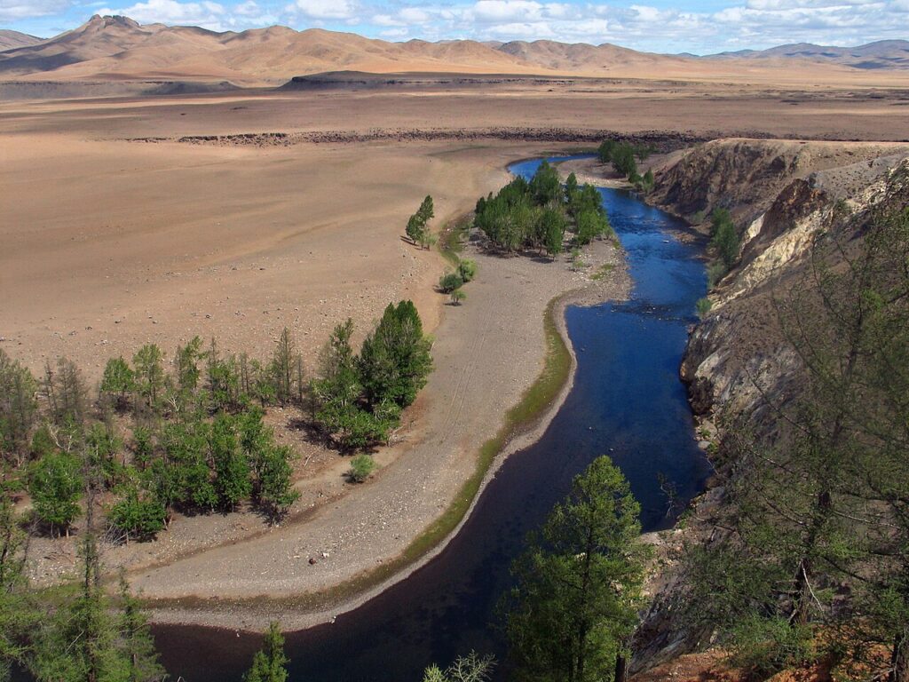
The Orkhon Valley Cultural Landscape, inscribed by UNESCO in 2004, encompasses 121,967 hectares along the Orkhon River in Arkhangai and Övörkhangai provinces, central Mongolia — the geographic heartland of the most extensive sequence of nomadic steppe empires in world history. The valley contains the ruins of Karakorum (哈拉和林, founded 1235 CE by Ögedei Khan as the capital of the Mongol Empire, then governing an empire extending from Korea to Poland), the Uyghur Khaganate capital of Ordu-Baliq (Khar Balgas, 744–840 CE), Turkic-period memorial complexes with the oldest surviving Old Turkic runic inscriptions (Bilge Khan and Kultegin stelae, 8th century CE), and Erdene Zuu Monastery (額爾德尼召, founded 1586 CE using stone from the ruins of Karakorum) — the first and most historically significant Buddhist monastery in Mongolia.
The Mongolian imperial heartland: Karakorum, Erdene Zuu and the steppe capital circuit Karakorum ruins · Erdene Zuu Monastery · Khar Balgas — within the inscription and up to 30 km
The Karakorum ruins, within the Orkhon Valley UNESCO inscription at Kharkhorin district, are the archaeological remains of the capital of the Mongol Empire at its maximum extent (1235–1260 CE), when Karakorum governed an empire stretching from the Pacific coast of Korea to the Adriatic Sea and from Siberia to the Persian Gulf — the largest contiguous land empire in human history. The city of Karakorum was described by the Franciscan friar William of Rubruck (who visited 1254 CE) and the Flemish diplomat Hayton of Corycus as a city with two distinct quarters (a Chinese craftsmen’s quarter and a Muslim merchants’ quarter), a dozen Buddhist temples, two mosques, and a Nestorian Christian church — a cosmopolitan administrative capital whose population of craftsmen and administrators was drawn from across the conquered territories. The city’s silver tree fountain (a remarkable automaton described by William of Rubruck as spouting wine, mares’ milk, rice wine, and mead from the mouths of silver lions at the base, topped by a silver angel that blew a trumpet signal when the Great Khan’s drinking vessels required refilling) was fabricated by the Parisian goldsmith Guillaume Boucher, who had been captured in Hungary during the Mongol invasion of Europe in 1241–1242 CE and brought to Karakorum as an artisan. The Mongolian capital moved from Karakorum to Khanbaliq (modern Beijing, established as capital by Kublai Khan in 1264 CE), and Karakorum was sacked by Ming dynasty forces in 1388 CE — the ruins excavated by Mongolian-German and Mongolian-Japanese archaeological teams since 1999 reveal the city’s street grid, palace foundations, and the physical scale of a mid-13th-century imperial capital that concentrated the wealth of two continents.
Erdene Zuu Monastery (額爾德尼召, also romanised as Erdene Zuu Khiid), within the Orkhon Valley inscription at the western edge of the Karakorum ruins, was founded in 1586 CE by Abtai Sain Khan, a Khalkha Mongolian ruler who had received Buddhist ordination from the Third Dalai Lama (Sönam Gyatso) during the Dalai Lama’s 1578 visit to Altan Khan’s court. The monastery was built directly from the stone of Karakorum’s ruins — the massive outer wall of Erdene Zuu incorporates 108 white stupas (the number 108 is sacred in both Buddhist and Hindu traditions as the count of mental afflictions, prayer beads in a mala rosary, and epithets of the Buddha) arranged along the perimeter, and the wall itself was built from Karakorum’s carved stone blocks. Three principal temples were erected in the 16th–17th century: the Zuun (Eastern, 1586 CE), Dund (Central, 1651 CE), and Baruun (Western, 1657 CE) temples, each built in a hybrid Mongolian-Tibetan architectural style with upswept Chinese tiled roofs, white-plastered masonry walls, and Tibetan-style interior shrine arrangements housing the three bodies of the Buddha (Dharmakaya, Sambhogakaya, and Nirmanakaya). Erdene Zuu was devastated during the Stalinist purges of 1937–1938, when Communist Mongolian authorities destroyed approximately 700 Buddhist monasteries and executed or imprisoned approximately 17,000 monks — Erdene Zuu survived as a museum; after 1990 it has functioned again as an active monastery and museum simultaneously, with resident monks conducting daily rituals in the preserved 17th-century temple buildings.
Twenty kilometres northwest of Karakorum within the Orkhon Valley inscription, the ruins of Khar Balgas (Ordu-Baliq, “the Palace City” in Old Turkic) are the archaeological remains of the capital of the Uyghur Khaganate (744–840 CE) — the state that succeeded the Second Turkic Khaganate on the Mongolian steppe and controlled the Orkhon Valley a century before the Mongolian Empire. The Orkhon Inscriptions — the Bilge Khan stele (724–735 CE) and the Kultegin memorial stele (732 CE), both preserved in situ near Khashaat district within the Orkhon Valley — are carved in the Old Turkic runic alphabet and represent the oldest surviving extensive texts in any Turkic language. The Kultegin inscription, carved by Yollïg Tigin (nephew of Bilge Khan) to commemorate the death of the prince Kultegin, contains 68 lines in Old Turkic and 13 lines in Chinese — a bilingual monument that documents the political relationships between the Turkic Khaganates and Tang dynasty China. The inscriptions’ translations (completed by Vilhelm Thomsen in 1893, a breakthrough in understanding the Turkic world) record the Turkic leaders’ exhortations to their people to resist Chinese cultural assimilation: “Because of the sweet words and gifts of the Chinese people, many Turkic people left; and because of that, the Turkic people died” — a document of steppe political philosophy at the moment of maximum Chinese-Turkic cultural confrontation in the Tang period.
Mongolia’s wider steppe heritage: Altai petroglyphs, Burkhan Khaldun and Uvs Nuur Mongolian Altai petroglyphs · Burkhan Khaldun · Uvs Nuur Basin — 500 to 900 km
Eight Hundred and Fifty Kilometres west of the Orkhon Valley by road via Ulaanbaatar (approximately 14–16 hours by road or by domestic flight from Ulaanbaatar to Ulgii in western Mongolia, approximately 3 hours), the Petroglyphic Complexes of the Mongolian Altai (UNESCO 2011) in Bayan-Ölgii Province preserve the longest unbroken sequence of rock art in Central Asia: approximately 10,000 petroglyphs carved on cliff faces and boulders in the Tsagaan Salaa and Baga Oigor valleys spanning from the Bronze Age (approximately 11,000–6,000 BCE) to the historical Turkic and Mongolian periods (6th–14th century CE). The oldest petroglyphs, carved in the early Holocene when the Altai was occupied by hunter-gatherers before the development of steppe pastoralism, depict wild fauna (ibex, red deer, aurochs, bears, wolves) in a distinctive Altai art style with outlined animal bodies and internal hatching patterns. The transition to Bronze Age pastoralism (approximately 3000–1000 BCE) is visible in the shift from hunting scenes to herding scenes and ceremonial processions — the petroglyphs document approximately 11,000 years of human adaptation to the Altai mountain environment in continuous visual record. From Ulaanbaatar, Ulgii is served by MIAT Mongolian Airlines (approximately 3 hours), making the Altai petroglyphs the most efficiently reached remote Mongolian UNESCO site for international visitors using Ulaanbaatar as a hub.
Six Hundred Kilometres northeast of the Orkhon Valley by road (approximately 10–12 hours from Karakorum/Kharkhorin to Khentii Province), the Great Burkhan Khaldun Mountain and its surrounding sacred landscape (UNESCO 2015) in Khentii Province is the birthplace and burial site of Chinggis Khan (Genghis Khan, c. 1162–1227 CE) — the individual who transformed the Orkhon Valley from the steppe heartland of the Uyghur and Turkic Khaganates into the administrative centre of the Mongolian Empire. Burkhan Khaldun (also spelled Burqan Qaldun) is the sacred mountain where Chinggis Khan is said to have taken refuge and prayed for protection as a young man during the persecution of his Borjigin clan, and where he vowed to return in gratitude. The mountain’s sacred status — as the “homeland of the Mongolian heartland” and the most venerated geographical site in Mongolian national culture — has made it a living place of pilgrimage where Mongolian shamanic and Buddhist rituals are performed at the mountain summit during the summer season. The precise location of Chinggis Khan’s tomb remains unknown — Mongolia’s most actively researched archaeological question — with the Burkhan Khaldun landscape designated as the most historically consistent candidate area by Mongolian and international scholars. From Ulaanbaatar, Khentii Province is reached by road (approximately 4–5 hours to Öndörkhaan, the provincial capital) or by occasional domestic flights.
Practical information
The Orkhon Valley Cultural Landscape is centred on Kharkhorin (Karakorum), 370 kilometres southwest of Ulaanbaatar by paved road (approximately 5–6 hours by shared minibus from Ulaanbaatar’s Dragon Bus Centre). The Mongolian Steppe Tourism loop — Ulaanbaatar → Karakorum (Orkhon Valley) → Khövsgöl Lake (nomad camps) → return to Ulaanbaatar — is the most travelled heritage itinerary in Mongolia and takes approximately 7–10 days with overnight stays in ger (traditional Mongolian felt tent) camps. The Karakorum Museum (opened 2011 at Kharkhorin) displays artefacts from the German-Mongolian excavations of Karakorum city (2000–2012) including ceramic fragments, iron tools, coins from across the Mongol Empire, and a scale model of the medieval city; entry is included in the combined Karakorum-Erdene Zuu ticket. Erdene Zuu Monastery is the most-visited individual heritage site within the inscription: the three Zuun/Dund/Baruun temples are open to visitors (photography permitted in the exterior spaces, restricted in temple interiors during monk ceremonies). Best season: June–September for green steppe scenery and accessible roads; the spring mud season (April–May) and winter cold (November–March, temperatures regularly reaching −30°C) make road travel difficult. Nomad ger camp accommodation is available near Kharkhorin at multiple tourist camps (with meals, hot showers, and guided excursions to Karakorum, Erdene Zuu, and the Orkhon Waterfall 50 km south). The Orkhon Waterfall (Ulaan Tsutgalan, approximately 20 metres high) in the basalt canyon of the Orkhon River south of the inscription, formed by a volcanic eruption approximately 20,000 years ago, is a practical extension to the UNESCO site.
Frequently Asked Questions
Why was Karakorum the capital of the Mongol Empire and how important was it really?
Karakorum was chosen as the Mongol imperial capital by Ögedei Khan (Chinggis Khan’s third son and successor) in 1235 CE for geopolitical rather than geographic reasons: it was positioned at the centre of the traditional steppe homeland of the Mongolian tribes, approximately equidistant from the empire’s major frontiers in China, Central Asia, and the Middle East, and on the Orkhon River — the same valley that had served as the heartland of the Xiongnu, Turkic, and Uyghur empires before the Mongols. Its importance is difficult to overstate: at its peak in the 1240s–1250s, Karakorum was the administrative centre of an empire governing approximately 100 million people across Eurasia and processing the flow of tribute, ambassadors, artisans, and slaves from Korea, China, Persia, Russia, Hungary, Poland, and the Armenian Kingdoms. The Franciscan William of Rubruck’s 1254 account describes a city with a Chinese quarter, a Muslim quarter, a Nestorian Christian church, two mosques, twelve Buddhist temples, and a mixed population of craftsmen from across the conquered territories — the cosmopolitan character of Karakorum was not incidental but strategic: Mongol policy actively relocated craftsmen from conquered cities (Chinese, Persian, Hungarian, Georgian, Armenian) to Karakorum to develop the empire’s administrative and manufacturing capacity. The city was, however, small by the standards of the cities it dominated: William of Rubruck estimated the settled population at a few thousand, with the imperial camps and nomadic entourage of the Great Khan surrounding the urban core. Karakorum’s geopolitical significance far exceeded its physical scale. After Kublai Khan moved the capital to Khanbaliq (modern Beijing) in 1264–1274 CE, Karakorum’s importance declined; the city was sacked by the Ming dynasty general Lan Yu in 1388 CE, and Erdene Zuu’s 1586 construction on the ruins represents the deliberate Mongolian cultural act of asserting Buddhist continuity over the memory of the imperial city.
What are the Orkhon Inscriptions and why do they matter for Turkic history?
The Orkhon Inscriptions are a set of carved memorial stelae erected in the Orkhon Valley by the Second Turkic Khaganate in the early 8th century CE, constituting the oldest surviving extensive texts in any Turkic language. The two principal stelae — the Bilge Khan memorial (c. 735 CE) and the Kultegin memorial (732 CE) — were commissioned by the Khaganate’s ruling family to record their victories, political philosophy, and warnings to future Turkic generations. They are written in the Old Turkic runic alphabet (Göktürk script), a writing system probably derived from Sogdian but adapted independently for the Turkic language, used from approximately the 6th to 11th centuries CE across the Eurasian steppe. The Kultegin inscription is the longer and more complete: 68 lines in Old Turkic and 13 in Chinese, carved by Yollïg Tigin, commemorating the death of Prince Kultegin (died 731 CE). The inscription’s most famous passage is a direct political address to the Turkic people warning against Chinese cultural assimilation: “Because of the sweet words and fine gifts of the Chinese people, you were drawn to them; many Turkic people have died because of this.” This passage is the earliest surviving statement of Turkic political consciousness as distinct from and in tension with the Chinese imperial sphere — a document of steppe political thought at the height of Tang dynasty China’s expansion. The inscriptions were deciphered by the Danish linguist Vilhelm Thomsen in 1893, in a breakthrough that opened the study of the Turkic world’s own literary and political history, supplementing the exclusively Chinese and Byzantine sources that had previously defined scholarly understanding of the steppe empires.
How do you travel to the Orkhon Valley and what should you expect logistically?
The Orkhon Valley is reached from Ulaanbaatar by road (370 km southwest, approximately 5–6 hours on a combination of paved highway and dirt track depending on the route and season). The most common approach for independent travellers is by shared minibus (mikr) from Ulaanbaatar’s Dragon Bus Centre (Naran Tuul area) to Kharkhorin town (the modern settlement adjacent to Karakorum/Erdene Zuu), departing most mornings when there are enough passengers. Organised tours from Ulaanbaatar typically include accommodation at a ger tourist camp near Kharkhorin, guided visits to Karakorum Museum and Erdene Zuu, and possible extensions to the Orkhon Waterfall (Ulaan Tsutgalan, approximately 50 km south of Kharkhorin in a basalt canyon). Road conditions: the main road from Ulaanbaatar southwest toward Karakorum is paved for the first 200 km to Arvaikheer; the final 100+ km to Kharkhorin is on a mix of tracks depending on the route chosen. Four-wheel-drive vehicles are recommended for the full Mongolian steppe circuit. Ger camp accommodation near Kharkhorin ranges from basic (no electricity, pit toilet) to mid-range tourist camps (solar power, hot shower, Mongolian meals). The Karakorum Museum (daily, 9:00–18:00 May–October, shorter hours in winter) costs approximately 5,000–8,000 MNT entrance; Erdene Zuu Monastery is approximately 5,000 MNT. Currency is Mongolian Tögrög; USD cash is accepted at most tourist camps and larger guesthouses. Mobile data coverage (3G/4G) is available in Kharkhorin town but patchy on the steppe between towns. The best strategy for international visitors is to book a 3–4 day Orkhon Valley tour through a Ulaanbaatar agency (Nomadic Expeditions, Karakorum Expeditions, and Ger to Ger are the most frequently cited options) rather than attempting to navigate independently on first visit.
EXCERPT: The Orkhon Valley Cultural Landscape (UNESCO 2004) — Karakorum, capital of the Mongol Empire 1235 CE; Erdene Zuu, Mongolia’s first Buddhist monastery 1586 CE; and the oldest Turkic runic inscriptions — in central Mongolia 370 km from Ulaanbaatar, with the Altai petroglyphs 850 km west and Burkhan Khaldun mountain 600 km northeast.
META: UNESCO World Heritage Sites near the Orkhon Valley Mongolia: Petroglyphic Complexes of the Mongolian Altai 850 km west, Great Burkhan Khaldun Mountain 600 km northeast, Uvs Nuur Basin transboundary with Russia — Mongolia’s complete steppe heritage circuit from Mongol Empire capital ruins to Bronze Age rock art.
Sources
- S1 — UNESCO World Heritage Centre — Orkhon Valley Cultural Landscape (Ref. 1081) — https://web.archive.org/web/20230601000000/https://whc.unesco.org/en/list/1081/
- S2 — UNESCO World Heritage Centre — Statement of Outstanding Universal Value (Ref. 1081) — https://whc.unesco.org/en/list/1081/
Spotted an error? Write to [email protected] and we correct it the same day.