
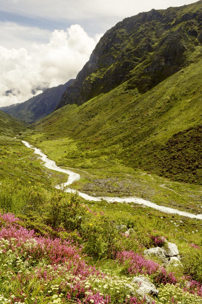
Khangchendzonga National Park (KNP, also romanised as Kangchenjunga National Park, or locally “Dzongu” for the northern sacred zone), inscribed by UNESCO in 2016 as a “mixed” site (recognising both natural and cultural Outstanding Universal Value — one of only a few “mixed” UNESCO sites in the world), is a national park and biosphere reserve in the state of Sikkim in northeastern India, covering approximately 1,784 km² of the central Sikkim Himalaya and centred on the Kangchenjunga massif — the world’s third-highest mountain at 8,586 m (after Everest at 8,848 m and K2 at 8,611 m), sacred to the Lepcha, Sikkimese, and Buddhist communities of Sikkim as “Khangchendzonga” (the “Five Treasuries of Great Snow”, the five peaks of the Kangchenjunga massif that represent in Sikkimese Buddhist belief the five treasuries — gold, silver, gems, grain, and holy scriptures — stored in the mountain for the welfare of the people). The UNESCO inscription’s dual “mixed” status reflects the Khangchendzonga National Park’s specific combination of globally significant biodiversity (the eastern Himalayan zone around Kangchenjunga is one of the most species-rich mountain systems in the world, at the intersection of the Himalayan, Yunnan-Guizhou, and Eastern Himalayan biodiversity hotspots) and the specific cultural significance of the mountain landscape to the Lepcha indigenous people (the “Rong”, the original inhabitants of Sikkim who have inhabited the Kangchenjunga watershed since before Tibetan Buddhist influence, for whom the Dzumsa governance system and the sacred mountain groves “Mayel Lyang” represent a spiritual relationship with the land that constitutes intangible cultural heritage of unique value).
Khangchendzonga’s Himalayan ecology and the Sikkim cultural landscape Kangchenjunga summits · Dzongu sacred zone · Yuksom · Gangtok · Darjeeling DHR — 0 to 120 km
The Khangchendzonga National Park’s biodiversity significance rests on its position at the junction of three major floristic and faunal zones: the eastern Himalayan system (where the monsoon influence from the Bay of Bengal is maximised, producing the highest biodiversity concentration in the Himalaya), the Yunnan-Guizhou plateau flora (which extends into the high-altitude zones of eastern Sikkim and contributes temperate broadleaf and rhododendron diversity), and the Tibetan plateau fauna (contributing the high-altitude grassland and cold-desert species of the trans-Himalayan zone above 4,500 m). The specific biodiversity numbers for the KNP reflect this junction position: approximately 550 bird species (including the Snow Partridge, the Blood Pheasant — the state bird of Sikkim — the Himalayan Snowcock, and rare raptors like the Saker Falcon and Lammergeier); approximately 45 species of mammals (including Snow Leopard, Red Panda — the state animal of Sikkim — Himalayan Black Bear, and the Tibetan Wild Ass or Kiang in the high-altitude zones); and approximately 532 species of plants (including 28 species of rhododendron — the eastern Himalayan rhododendron diversity is globally exceptional, with the May flowering season producing forests of 25–30 m trees in full bloom above Yuksom and Dzongri). The cultural component of the UNESCO inscription centres specifically on the Lepcha “Mayel Lyang” concept — the Lepcha cosmological narrative identifies the Kangchenjunga watershed as the original homeland of the Lepcha people, a sacred land of abundance and spiritual power that is maintained through specific ritual observances, forest-use restrictions (sacred groves where no cutting is permitted), and the Dzumsa communal governance system of the Dzongu area (the northern Sikkim zone adjacent to the park that is designated as a Lepcha reserve, accessible only to Lepchas and their officially authorized guests). The Lepcha sacred landscape practice functions as a de facto conservation mechanism — the sacred groves and water source areas under Lepcha spiritual protection have been identified as some of the best-preserved forest remnants in Sikkim.
Gangtok (the Sikkim state capital, approximately 120 km east of the KNP’s eastern boundary, accessible by road in approximately 3–4 hours — the commercial and administrative centre of Sikkim, with Tibetan Buddhist monasteries including the Rumtek Monastery, seat of the Kagyu sect of Tibetan Buddhism, and the Enchey Monastery above Gangtok) and the Darjeeling Himalayan Railway (UNESCO, approximately 100 km south of Gangtok across the West Bengal border — see separate CHO article on Indian Mountain Railways) complete the regional heritage context. The KNP itself is accessed via Yuksom (Yuksam, the first capital of Sikkim, where the first Chogyal — “Divine Ruler” — of Sikkim was crowned in 1642 CE, and the starting point for the Goecha La high-altitude trek to the base of Kangchenjunga) and the Dzongri plateau (approximately 4,020 m, the primary high-altitude trekking destination above Yuksom, with panoramic views of the Kangchenjunga massif).
Practical information
The KNP is accessed from Yuksom (Pelling district, approximately 140 km from Gangtok by road, 3.5–4 hours). Sikkim requires an Inner Line Permit (ILP) for all non-Sikkim residents of India, and a Protected Area Permit (PAP) for all foreign nationals — obtain at the Sikkim Tourism offices in Gangtok, Darjeeling, or at the border checkpost at Rangpo (the West Bengal–Sikkim border, where vehicles enter Sikkim on NH10). The nearest airport is Pakyong Airport (PYG, operational since 2018, 35 km from Gangtok, with connections to Kolkata and Delhi — subject to frequent fog-related cancellations, particularly October–March). Alternative access: New Jalpaiguri (NJP) railway station in West Bengal (approximately 120 km from Gangtok, 4 hours by road) or Bagdogra Airport (IXB, 130 km from Gangtok, major domestic hub). The Goecha La trek from Yuksom (62 km round trip, 8–9 days, maximum altitude 4,940 m at Samiti Lake, near view of the Kangchenjunga South Face) is the flagship high-altitude trek in the KNP; it requires a trekking permit from the Forest Department in Yuksom, a registered guide, and pre-arranged camping equipment and porters (available in Yuksom). Best trekking season: April–May (rhododendron bloom, pre-monsoon clear weather) and October–November (post-monsoon, exceptional visibility of the Kangchenjunga massif). The monsoon (June–September) brings heavy rainfall and leech-infested trails at lower altitudes; the trek is possible but requires rain gear and advance preparation. The Dzongu (northern Sikkim Lepcha reserve) requires specific permits that must be organised in advance through the Sikkim Tourism Department.
Frequently Asked Questions
What makes the Khangchendzonga National Park a “mixed” UNESCO World Heritage site?
The UNESCO “mixed” site designation is applied to a World Heritage property that meets Outstanding Universal Value criteria for both natural heritage (the natural criteria i–iv) and cultural heritage (the cultural criteria i–vi) simultaneously — a category that as of 2023 includes only 39 of the 1,157 UNESCO World Heritage sites globally, making it the rarest form of UNESCO inscription. Most UNESCO sites are purely natural (meeting criteria i–iv: geological/biological phenomena, exceptional biodiversity, ecosystem significance) or purely cultural (meeting criteria i–vi: human creative genius, values exchange, civilisational testimony, typological example, traditional settlement, or intangible significance). The Khangchendzonga National Park was inscribed as “mixed” specifically because the UNESCO evaluation committee concluded that the Outstanding Universal Value of the site could not be fully described by either natural or cultural criteria alone: the natural value is the exceptional biodiversity of the eastern Himalayan mountain system (meeting natural criterion x for the conservation of threatened species, with documented populations of Snow Leopard, Red Panda, and at least 7 globally threatened bird species) and the geological/landscape value of the Kangchenjunga massif as one of the most dramatic mountain landscapes on earth (meeting natural criterion vii for natural beauty and aesthetic importance). The cultural value that justified the “mixed” designation is the Lepcha “Mayel Lyang” sacred mountain concept — the UNESCO evaluation committee recognised that the Lepcha community’s spiritual relationship with the Kangchenjunga landscape, including the specific sacred groves, water source protection practices, and Dzumsa communal governance system that have maintained the ecological integrity of the northern Dzongu area for generations, constitutes “outstanding testimony to the living cultural tradition” of the Lepcha people that meets cultural criterion iii (outstanding testimony to a living cultural tradition). The significance of the “mixed” designation is that it represents an important evolution in UNESCO’s approach to mountain sacred landscapes: the traditional UNESCO framework separated “natural” landscapes (valued for biodiversity and geology) from “cultural” landscapes (valued for human modification and association), and the Khangchendzonga inscription was a landmark recognition that indigenous sacred mountain landscapes constitute a third category — “associated cultural landscapes” where the Outstanding Universal Value is inseparable from the combination of ecological and spiritual significance. The 2016 Khangchendzonga inscription followed similar reasoning to the earlier mixed inscription of the Tongariro National Park in New Zealand (1993, the first inscribed property under the “associative cultural landscape” concept, where the Maori sacred mountain landscape of Ruapehu, Tongariro, and Ngauruhoe was recognised for its cultural significance alongside the volcanic geological value) and contributed to the growing body of UNESCO jurisprudence on indigenous sacred landscape conservation.
What is the Lepcha people’s relationship with the Kangchenjunga mountain?
The Lepcha (who call themselves “Rong”, meaning “ravine people” in the Lepcha language — an Austro-Tibetan language of the Sino-Tibetan family, written in the distinctive Lepcha script — a silabic alphabet created approximately in the 17th century CE, one of very few scripts invented for a single language by a single historical figure, attributed to the sage-scholar Thikung Men Salong) are the indigenous people of Sikkim — the original inhabitants of the Kangchenjunga watershed before the arrival of the Tibetan Namgyal dynasty (who established the Sikkim kingdom in the 17th century CE) and the subsequent Nepali immigration (which made Nepali-speaking communities the majority population in Sikkim by the 19th century). The Lepcha cosmological tradition identifies the Kangchenjunga watershed as “Mayel Lyang” — “Mayel” meaning “paradise” or “the original land” and “Lyang” meaning “country” or “valley”: the Lepcha origin narrative holds that the first Lepcha couple (Fodongthing and Nazong Nyu) were created by the god Itbu-mu on the summit of Kangchenjunga and descended to populate the river valleys — a creation-from-the-mountain narrative that makes Kangchenjunga itself the sacred origin point of the Lepcha people. The practical consequences of this cosmological relationship for the contemporary landscape are: (1) the Kangchenjunga summit is regarded as permanently sacred and inviolable — the Sikkimese government has historically agreed not to permit summit attempts on Kangchenjunga from the Sikkim side (the Nepali side allows climbing from the Nepal route, which does not cross the Sikkim boundary), and the mountain had its first ascent from the Sikkimese side only with the specific agreement that climbers would stop a few feet below the true summit in deference to the mountain’s sacredness; (2) the Dzongu area (the northern Sikkim Lepcha ancestral territory adjacent to the park) is administered as a restricted zone where access requires specific permits, preserving the Lepcha community’s relationship with their ancestral land from tourist intrusion; (3) the “Mayel Lyang” sacred groves — specific forest patches identified by Lepcha tradition as inhabited by protective spirits and therefore exempt from cutting — have been identified by conservation biologists as some of the best-preserved old-growth forest remnants in Sikkim, providing habitat for rare species that have disappeared from unprotected forest areas. The Lepcha community’s current population in Sikkim is approximately 60,000–80,000 people (approximately 13% of Sikkim’s total population of approximately 600,000) — a significant reduction from their former majority status before Nepali immigration. The Lepcha identity and cultural practices are maintained by community organisations in Dzongu and by the Lepcha language and script education programmes in Sikkim schools; the UNESCO recognition of the “Mayel Lyang” sacred landscape concept in the mixed heritage inscription has provided international validation for the Lepcha community’s advocacy for the protection of their ancestral territory.
EXCERPT: Khangchendzonga National Park, UNESCO mixed heritage site inscribed in 2016, encompasses the world’s third-highest mountain (8,586 m, sacred to the Lepcha people as the Five Treasuries of Great Snow), 28 rhododendron species, Snow Leopard and Red Panda — the only UNESCO site in India inscribed for both natural biodiversity and indigenous cultural significance.
META: UNESCO World Heritage Sites near Khangchendzonga National Park Sikkim India: Indian Mountain Railways Darjeeling (100 km south, UNESCO 1999), Nanda Devi National Park Uttarakhand (UNESCO 1988) — Sikkim Kangchenjunga trekking Goecha La, Lepcha Mayel Lyang sacred mountain, eastern Himalaya biodiversity Red Panda Snow Leopard, Yuksom Dzongri plateau.
Sources
- S1 — UNESCO World Heritage Centre — Khangchendzonga National Park (Ref. 1513) — https://web.archive.org/web/20230601000000/https://whc.unesco.org/en/list/1513/
- S2 — UNESCO World Heritage Centre — Statement of Outstanding Universal Value (Ref. 1513) — https://whc.unesco.org/en/list/1513/
Spotted an error? Write to the editors and we correct it the same day.