Hội An Ancient Town — inscribed by UNESCO in 1999 — preserves the most complete and best-maintained example of a Southeast Asian trading port town from the 15th to 19th centuries CE: a compact historic quarter of approximately 1,000 classified buildings on the banks of the Thu Bồn River in central Vietnam, where Japanese merchants, Chinese traders, and Vietnamese, Dutch, Portuguese, and Indian merchants converged during the peak of the town’s maritime trade (16th–17th centuries CE), each community leaving architectural traces that together produced a uniquely hybrid urban landscape — wooden shophouses with Chinese roof tiles, Japanese-designed covered bridges, Fujian-style Chinese community assembly halls (hội quán), Vietnamese tube houses, and French colonial facades — all preserved in exceptional condition because the silting of the Thu Bồn River estuary in the 19th century CE ended Hội An’s role as a working port before the 20th century’s wars and development could reach it.
The Japanese Covered Bridge, the Chinese assembly halls, and five centuries of merchant town architecture Japanese Covered Bridge (Chùa Cầu — built approximately 1593 CE, the emblem of Hội An, a roofed bridge with a temple inside, built by the Japanese merchant community to connect the Japanese quarter with the Chinese quarter) · Phúc Kiến Assembly Hall (Hội Quán Phúc Kiến — the largest and most lavishly decorated of the five Chinese community halls, built 1697 CE by the Fujian/Hokkien merchant community) · Tấn Ký House (a preserved 18th-century Vietnamese merchant’s tube house, 7 generations in the same family, now open as a museum) · Phước Lâm Pagoda · Trần Family Chapel — Quảng Nam Province, central Vietnam
Hội An (historically known in Western sources as “Faifo” — the Portuguese/Dutch corruption of the Vietnamese name, which appears in European commercial records from the 16th century CE onward) developed as a major maritime trading port in the 15th–16th centuries CE, taking advantage of its position at the mouth of the Thu Bồn River on the central Vietnamese coast — a natural harbour protected from the South China Sea by offshore barrier islands, with the river providing access to the productive agricultural hinterland of the Quảng Nam province and to the inland sources of commodities (silk, lacquer, cinnamon, pepper, and elephant ivory) that made central Vietnam attractive to Asian and European traders. The Cham Kingdom (the Indianised maritime empire that had controlled the central Vietnamese coast for over a millennium before Vietnamese expansion southward in the 14th–15th centuries CE) had already established a trading settlement at the Thu Bồn River mouth that would evolve into Hội An; the characteristic Cham brick towers (the My Son Sanctuary, 40 km to the southwest) represent the religious architecture of this pre-Vietnamese cultural tradition. The Japanese merchant community in Hội An was established by the late 16th century CE — Japanese trading ships (the shuinsen, or red-seal ships, licensed by the Japanese Tokugawa government for foreign trade) called regularly at Hội An from approximately 1560 CE, and a permanent Japanese merchant quarter grew up on the north bank of the Thu Bồn River. The Japanese quarter is now almost entirely gone (the Japanese community left when the Tokugawa government’s sakoku (isolation) edicts of 1633–1635 CE prohibited Japanese nationals from trading overseas — merchants who remained could not return to Japan), but the Japanese Covered Bridge (Chùa Cầu — the “Bridge Pagoda”) remains: a wooden roofed bridge spanning the small creek that separated the Japanese and Chinese quarters, built approximately 1593 CE by the Japanese community and incorporating a small temple dedicated to Trấn Võ Bắc Đế (the Northern God of Protection) — the most photographed building in Hội An and the image on the Vietnamese 20,000-đồng banknote. The Chinese merchant communities (primarily from Fujian/Fukien province — Hokkien-speaking merchants who dominated maritime trade across Southeast Asia from the 16th century CE onward — but also from Guangdong, Teochew, Hainan, and other Chinese regions) established permanent settlements in Hội An and built five elaborate community assembly halls (hội quán) in the 17th–18th centuries CE: the Phúc Kiến Hall (Hội Quán Phúc Kiến, built 1697 CE by the Hokkien community — the largest, dedicated to the Goddess of the Sea, Thiên Hậu/Mazu, whose veneration was universal among Fujian maritime traders; its interior is an extraordinary accumulation of 300 years of votive objects, painted carvings, incense burners, and lacquered altars), the Quảng Đông Hall (Cantonese community), the Triều Châu Hall (Teochew community), the Hải Nam Hall (Hainan community), and the Trung Hoa Hall (united Chinese community hall). The Vietnamese tube house (nhà ống — the characteristic commercial building type of the Hội An historic quarter: a long narrow house whose street frontage is typically only 4–5 metres wide but extends 20–30 metres deep through a series of rooms and open courtyards, maximising street frontage while accommodating all the functions of a merchant’s house: shop at the front, storage in the middle, living quarters at the back, with an open courtyard for ventilation and light in the tropical climate) is represented by the Tấn Ký House (a preserved example from the early 18th century CE, owned continuously by the same Tấn Ký family for seven generations, now open to visitors — a museum of the merchant way of life that sustained Hội An’s economy for centuries, with Japanese-style roof trusses, Chinese ceramic wall panels, and Vietnamese lacquer furniture coexisting in a single building space). Hội An’s remarkable preservation is directly attributable to its economic decline: the silting of the Thu Bồn River estuary in the early 19th century CE made the town’s harbour inaccessible to large trading vessels, shifting maritime trade to Da Nang (approximately 25 km to the north); the decline in commerce meant that there was neither the money nor the incentive to rebuild or modernise the historic buildings; and the economic stagnation preserved the 18th-century urban fabric essentially intact through the French colonial period, the wars of the 20th century CE, and the rapid development that followed Vietnamese reunification in 1975 CE.
Practical information
Hội An is located in Quảng Nam Province approximately 25 km south of Da Nang and 120 km south of Hué. Da Nang International Airport (DAD) is the primary gateway — international flights and connections to Hanoi and Ho Chi Minh City; Hội An is approximately 30–40 minutes from Da Nang by taxi or bus. The UNESCO-protected historic quarter (the Ancient Town) is compact and navigable on foot or by bicycle — the town is effectively car-free in the historic core. The combined heritage ticket (approximately $5–7 USD) gives admission to five heritage sites within the historic quarter (including the Japanese Covered Bridge, two assembly halls, one tube house, and one community house) and must be purchased to enter most classified buildings. The Phúc Kiến Assembly Hall, Tấn Ký House, and the Japanese Covered Bridge are the priority visits; allow approximately 3–4 hours. The night market along the river (18:00–22:00 daily) is when the lanterns are lit and the town’s most photographed atmosphere occurs. Best season: February–May and July–August (dry season and lower temperatures). The monthly Full Moon Lantern Festival (the 14th of each lunar month) sees the entire town lit only by lanterns and candlelight — the most atmospheric time to visit.
Frequently Asked Questions
Why is Hội An so well preserved compared to other historic Vietnamese cities?
Hội An’s exceptional state of preservation — approximately 1,000 classified historic buildings survive in the town’s UNESCO-protected core, compared to the few dozen or few hundred historic buildings that survived in most other Vietnamese cities — is the result of a specific economic trajectory that decoupled the town from the development pressures of the 19th and 20th centuries CE. The mechanism: Hội An was a working international trading port from the 15th century CE, growing rapidly through the 16th and 17th centuries CE when it was one of the major ports of Southeast Asia, comparable in commercial significance to Malacca, Batavia, and Manila. The town’s prosperity during this peak period created the stock of high-quality commercial and residential architecture — the Chinese assembly halls, the Japanese-influenced roofed bridge, the Vietnamese tube houses — that constitute the current UNESCO heritage ensemble. The decisive event was the progressive silting of the Thu Bồn River estuary during the late 18th and early 19th centuries CE, a natural process accelerated by deforestation of the Quảng Nam hinterland, which reduced the harbour channel depth from sufficient for large ocean-going junks to too shallow for anything but small coastal vessels. By approximately 1820–1840 CE, major maritime trade had shifted to Da Nang’s deeper harbour, and Hội An had become a quiet provincial market town. The economic consequence was stagnation: no money to tear down old buildings and construct new ones, no industrial development to drive urban expansion, no wealthy patron class demanding fashionable modern architecture. The French colonial period brought a thin overlay of colonial facades to some buildings on the main commercial streets but left the historic fabric largely intact. The wars of the 20th century CE (the French Indochina War and the Vietnam War) also largely spared Hội An — both major conflicts were concentrated in the north around Hué and around Saigon; Hội An’s provincial insignificance protected it from the strategic bombing and urban fighting that destroyed the centres of Hué and other Vietnamese cities. The result of 200 years of economic stagnation: approximately 1,000 buildings from the 15th–19th centuries CE survived intact, constituting one of the largest concentrations of pre-modern urban architecture in mainland Southeast Asia.
What were the Japanese merchant community’s contributions to Hội An and why did they leave?
The Japanese merchant community at Hội An (established by approximately the 1560s–1570s CE and at its peak numbering several hundred permanent residents in the late 16th century CE) was one of the earliest and most significant Japanese merchant settlements in mainland Southeast Asia — a product of the shuinsen (red-seal ship) trading system licensed by the Toyotomi and early Tokugawa governments, which allowed Japanese merchants to travel to Southeast Asian ports to trade silk, copper, and precious metals for Japanese silver (the primary Japanese export commodity of the period, produced in large quantities from the mines of western Honshu). The Japanese community settled in a defined quarter on the north bank of the small creek that separated the Japanese and Chinese commercial districts, built their own residences and temples, and organised their commercial activities through the Japanese merchant guild structure. The Japanese Covered Bridge (built approximately 1593 CE according to the Chinese cyclical year carved in its foundation) is the primary physical remnant: a wooden bridge approximately 18 metres long, covered by a tiled roof, incorporating a small temple with two dog and two monkey statues at its ends (animals associated with the years 1596 and 1608 CE in the Chinese zodiac — dates traditionally associated with the bridge’s construction). The departure of the Japanese community: the Tokugawa shogunate’s sakoku (closed country) edicts of 1633 and 1635 CE prohibited Japanese subjects from travelling overseas, ordered all Japanese living abroad to return to Japan, and prohibited Japanese ships from engaging in foreign trade. The practical effect at Hội An was the immediate departure of most of the Japanese merchant community — those who remained could not return to Japan and thus did not; the Japanese community’s last identifiable members disappear from Vietnamese records by approximately the 1650s–1660s CE. The architectural legacy they left — primarily the Covered Bridge — was subsequently maintained by the Vietnamese and Chinese communities who recognised its importance for the town’s commercial identity, and the bridge has been rebuilt and restored multiple times since the 17th century CE while retaining its original form.
How does Hội An’s lantern tradition relate to the town’s heritage?
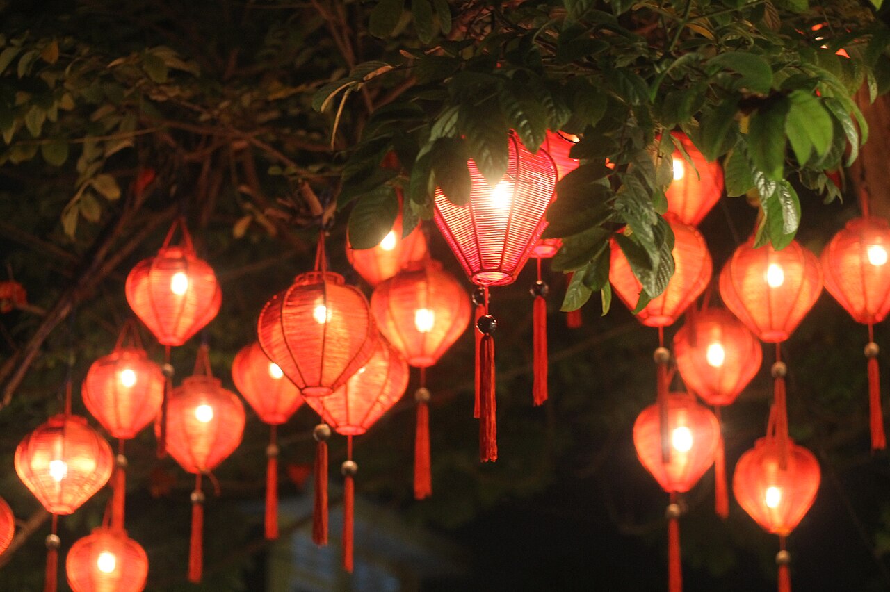
Hội An’s lantern tradition (the manufacture, display, and sale of silk and paper lanterns in the characteristic barrel and globe forms associated with the town’s visual identity) is a genuine historical survival — lanterns were used throughout the town’s history for illumination, festival decoration, and as votive objects in the Chinese temple and assembly hall traditions — but its current prominence as the defining visual symbol of Hội An’s tourism identity is a 20th-century development that has been deliberately cultivated. The historical background: lantern manufacture is recorded in Hội An from at least the 18th century CE, connected to the town’s role as a centre for silk weaving and dyeing (the Thu Bồn River valley’s mulberry orchards and silk-weaving villages supplied the raw materials) and to the Chinese community’s cultural traditions of festival illumination (the Lantern Festival, or Tết Nguyên Tiêu, on the 15th of the first lunar month is one of the great occasions for lantern display in Chinese cultural practice, and Hội An’s Chinese community celebrated it on a large scale). The monthly lantern festival (Đêm Rằm Phố Cổ — observed on the 14th of each lunar month) is a more recent creation: beginning in 1998 CE, the town’s authorities established a monthly festival evening in which the electric street lights of the historic quarter are extinguished and the town is lit only by lanterns — the coloured silk lanterns of the shops and houses, the paper floating lanterns released on the Thu Bồn River, and the candles in the windows and doorways of the historic buildings. The festival has grown into one of the most heavily marketed tourism events in Vietnam, drawing large crowds of domestic and foreign tourists on each full moon. The lantern manufacturing industry has grown to supply this demand: approximately 40–50 workshops in Hội An’s historic quarter now produce lanterns for sale to tourists and for use in the monthly festival, employing traditional silk-and-bamboo-frame construction techniques. The lantern trade has thus become economically central to the heritage town’s commercial identity — an authentic craft tradition amplified and commercialised in response to tourism demand, in a pattern common to successful heritage destinations globally.
EXCERPT: Hội An Ancient Town Vietnam (UNESCO 1999) — Southeast Asia’s best-preserved medieval trading port: the Japanese Covered Bridge (1593 CE), five Fujian Chinese assembly halls, Vietnamese tube houses owned for seven generations — 1,000 classified historic buildings from the 15th–19th centuries CE, preserved by 200 years of economic stagnation after the Thu Bồn harbour silted.
META: UNESCO World Heritage Sites near Hội An Ancient Town Vietnam: Complex of Hué Monuments 120 km north, Mỹ Sơn Sanctuary 40 km southwest — central Vietnam heritage circuit combining the imperial capital at Hué, the medieval trading port of Hội An, and the Cham temple complex of Mỹ Sơn.
Sources
- S1 — UNESCO World Heritage Centre — Hoi An Ancient Town (Ref. 948) — https://web.archive.org/web/20230601000000/https://whc.unesco.org/en/list/948/
- S2 — UNESCO World Heritage Centre — Statement of Outstanding Universal Value (Ref. 948) — https://whc.unesco.org/en/list/948/
Spotted an error? Write to editorial@culturalheritageonline.com and we correct it the same day.