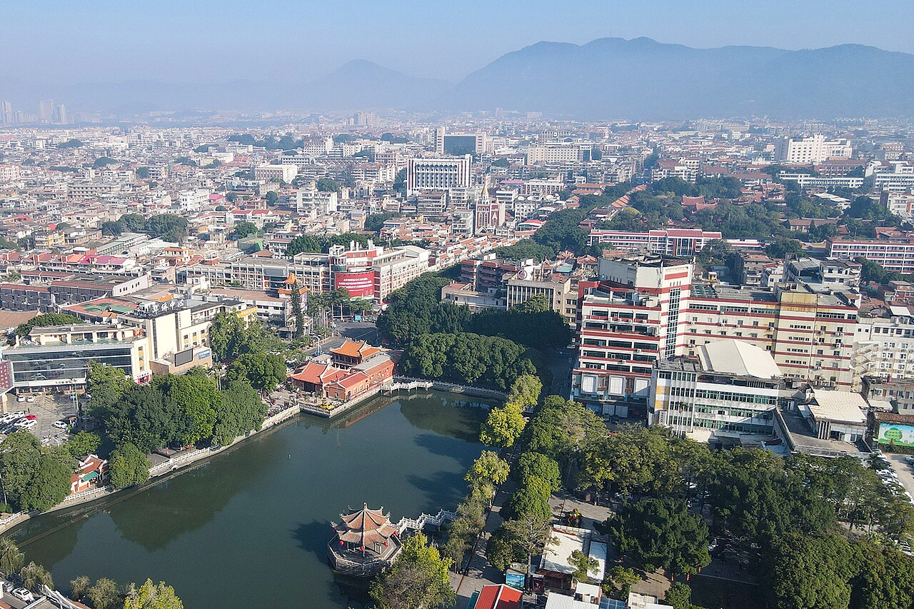
Quanzhou: Emporium of the World in Song-Yuan China, inscribed by UNESCO in 2021 as a serial site with 22 component properties distributed across Quanzhou City and the surrounding area of Fujian Province, documents the material remains of one of the most cosmopolitan maritime trading cities in medieval world history — a port city that Marco Polo (who visited circa 1291 CE, calling it “Zayton” from the Arabic name Al-Zaytun, “the olive tree”) described as “the greatest harbour in the world”, where merchants from India, Arabia, Persia, East Africa, and the Mediterranean world traded silks, porcelains, spices, and exotic commodities alongside Chinese merchants in a multicultural trading entrepôt that sustained a resident foreign merchant community of tens of thousands during the height of its commercial activity in the 10th–14th centuries CE. The inscription’s Outstanding Universal Value rests on the 22 component sites’ collective documentation of Quanzhou’s function as the primary maritime Silk Road trade hub of the Song (960–1279 CE) and Yuan (1271–1368 CE) dynasties: the Jiuri Mountain Prayer Sites (石刻祈风石刻, the cliff-face inscriptions documenting the annual prayer ceremonies performed by Quanzhou’s maritime customs officials for the safe return of the merchant fleet, with 13 surviving inscription panels spanning 1174–1266 CE); the Qingjing Mosque (清净寺, founded 1009 CE, one of the oldest surviving mosques in China, built by the Arab merchant community of Quanzhou in the Mamluk Egyptian architectural style with pointed-arch facades); the Kaiyuan Temple (开元寺, founded 686 CE, Quanzhou’s most important Buddhist institution, with twin pagodas — the East Pagoda and West Pagoda — that are the defining monuments of the Quanzhou skyline); the Maritime Trade Museum; and the Luoyang Bridge (洛阳桥, completed 1059 CE by the Quanzhou prefect Cai Xiang, a 1,200-metre-long masonry beam bridge over the Luoyang River estuary, the first bridge in China to use the oyster-encrustation technique for foundation stabilisation and one of the most significant engineering innovations in pre-modern bridge construction).
Quanzhou’s maritime world: from Fujian coast to the Song-Yuan global network Kulangsu Xiamen Fujian · Wuyi Mountain Fujian · Tulou earthen fortresses — 80 to 200 km
Eighty Kilometres south of Quanzhou by road and HSR (approximately 35 minutes from Quanzhou Station to Xiamen North on the Fuzhou-Xiamen HSR), Kulangsu (Gulangyu) Historic International Settlement (inscribed 2017) represents Quanzhou’s direct successor in the Fujian coastal maritime trade tradition — the 19th–20th-century treaty-port phase of the same Minnan coastal cosmopolitanism that produced Quanzhou’s medieval multi-faith trading emporium. The cultural continuity is deep: the Minnan language spoken in Quanzhou and Xiamen is the same language dialect family; the merchant family networks that built Kulangsu’s villas in the early 20th century were typically descended from Quanzhou and Zhangzhou merchant families who had migrated to Southeast Asia in the 14th–19th centuries and were returning to their ancestral region; and the overseas Chinese (Nanyang Huaqiao) architectural hybrid style of Kulangsu — combining European neoclassical ornament with Minnan vernacular construction — is the 20th-century expression of the same cultural openness to foreign influence that produced the 10th-century Qingjing Mosque and Hindu temple in Song-dynasty Quanzhou. From Quanzhou, Kulangsu and Xiamen are reached by the Fuzhou-Xiamen HSR (approximately 35 minutes from Quanzhou to Xiamen North; ferry from Xiamen mainland to Kulangsu approximately 15 minutes). The recommended 2-day Fujian coastal circuit: Quanzhou (1 day, Old City walking circuit) → Xiamen/Kulangsu (1 day, ferry access, piano museum, International Settlement architecture).
Two Hundred Kilometres west of Quanzhou by road (approximately 2.5 hours from Quanzhou to the Fujian Tulou cluster at Yongding County via the G25 Expressway through Zhangzhou and the Longyan-Yongding road), the Fujian Tulou (福建土楼, inscribed 2008) represent the Minnan rural counterpart to Quanzhou’s maritime cosmopolitanism — the earthen communal fortresses of the Hakka and Minnan rural communities that lived in the mountainous Fujian interior, away from the coast’s commercial exposure. The Tulou builders were the same Fujian population whose coastal relatives built the Quanzhou trading houses — the same Minnan cultural identity expressed in two completely different physical forms: the Quanzhou old town’s urban grid of narrow lanes, merchant buildings, and multi-faith religious institutions facing the ocean; and the Yongding mountain valley’s circular or square earth-walled communal buildings facing inward, designed for maximum self-sufficiency in a bandit-prone rural landscape. The Tulou’s defensive earthen walls (1–1.5 metres thick rammed-earth walls, with only one external entrance, internal water wells, and food storage) reflect the Minnan rural community’s defensive necessity in the rugged Fujian interior; the Quanzhou old city’s open commercial layout reflects the coastal community’s dependence on open trade and foreign relationships. From Quanzhou, the Yongding Tulou cluster is reached by road (approximately 2.5 hours) or by rail to Longyan City and then by coach to Yongding County (approximately 3.5 hours total).
Practical information
Quanzhou’s 22 component heritage sites are distributed across the Quanzhou old city (the concentrated urban heritage zone within the former Song-Yuan city walls, approximately 3 km × 2 km, walkable in a full day) and the surrounding Quanzhou Bay area (outlying sites including the Jiuri Mountain Prayer Inscriptions, Luoyang Bridge, and the Anping Bridge — a 2,255-metre-long stone bridge completed 1138 CE over the Anhai Bay estuary, the longest pre-modern bridge in China). The recommended walking circuit through the old city: Tianhoudian (天后宫, Mazu Temple, on the former Song-dynasty wharf front) → Quanzhou Maritime Museum → Qingjing Mosque → Kaiyuan Temple (with its twin Pagodas and museum of imported Islamic tombstones — the approximately 300 Song-Yuan-period Arabic-script tombstones from the Muslim merchant community’s cemetery, now incorporated in the Kaiyuan Temple grounds) → the Old City lanes (the zhongshan lu commercial street and the adjacent residential alley network) → Luoyang Bridge (approximately 10 km north of the old city, accessible by taxi or tourist bus, the 1059 CE masonry estuary bridge). Quanzhou is served by Quanzhou Jinjiang Airport (JJN, approximately 12 km south of the old city), with connections to major Chinese cities, and by the Fuzhou-Xiamen HSR at Quanzhou Station (approximately 5 km north of the old city, accessible by urban bus). Best visiting season: October–April (mild Fujian coastal temperatures, 18–24°C, lower typhoon risk than the June–September monsoon season). From Shanghai, Quanzhou is approximately 3.5 hours by the Shanghai-Fuzhou-Xiamen HSR via Fuzhou.
Frequently Asked Questions
What made Quanzhou the world’s greatest maritime port in the Song-Yuan period and how did it operate?
Quanzhou’s rise as the primary maritime trade hub of the Song-Yuan period was the result of a unique convergence of natural geography, administrative policy, and cultural cosmopolitanism that no other Chinese port was able to replicate simultaneously. The natural geographic advantages: Quanzhou Bay provides one of the best natural deep-water anchorages on the Fujian coast (the bay’s depth and the sheltering effect of Jinmen Island at the bay entrance allowed the largest ocean-going vessels of the medieval period — Arab dhows of 200–400 tonnes, Chinese junks of 300–600 tonnes — to anchor safely), and the bay’s position on the east Fujian coast places it at the optimal embarkation point for the summer southwest monsoon that carried vessels south and west to the Malay Straits, the Indian Ocean, and the Persian Gulf (the same monsoon, reversed in winter, returned north to Quanzhou, making the sailing cycle approximately 1 year round trip). The administrative policy advantage: the Song government established a Shibo Si (市舶司, Maritime Trade Supervisorate) at Quanzhou in 1087 CE, making it one of only three official maritime trade ports in Song China (alongside Guangzhou and Mingzhou/Ningbo), which concentrated the commercial infrastructure (bonded warehouses, inspection facilities, customs collection, accommodation for foreign merchants) that made Quanzhou the preferred port for international merchants who needed official documentation for their trade goods. The cultural cosmopolitanism: the Quanzhou Shibo Si had a remarkably permissive attitude toward foreign merchants’ cultural practices — the Song government allowed foreign merchants to establish their own religious institutions (the Qingjing Mosque, the Hindu temples dedicated to Shiva, the Manichean temple, the Nestorian church, the Jewish community’s facilities), operate their own commercial quarter (the Fan Fang, 蕃坊, “Foreigner Quarter”), and adjudicate civil disputes among themselves under their own customary law. The result was the most religiously and culturally diverse city in Song China: archaeological excavations in Quanzhou’s old city have recovered Islamic tombstones in Arabic and Persian, Hindu deity sculptures in South Indian iconographic styles, Manichean religious paintings, and Buddhist religious objects — all from the same stratigraphic contexts, confirming the simultaneous coexistence of multiple religious communities in the city’s commercial height.
Who were the Semu people and what was their role in Quanzhou’s Yuan-dynasty commercial dominance?
The Semu (色目人, Sèmù Rén, “People of Various Eyes” or “People of Various Categories”) were the Central Asian, West Asian, and European ethnic groups who occupied the second tier of the Yuan dynasty’s four-class social hierarchy (below the Mongols, above the Han Chinese, and above the Southern Chinese of the former Song territory) — the classification applied to Persians, Arabs, Central Asian Turks, Uighurs, Armenians, and even some Western Europeans who served the Yuan imperial administration as officials, merchants, and financial agents. In Quanzhou, the Semu community — primarily Muslim Arabs and Persians from families with multi-generational roots in the city’s foreign merchant quarter — had established themselves as the dominant force in the maritime trade from the 12th century onward; the transition from Song to Yuan (1279 CE) dramatically elevated their social status, as the Yuan court’s preference for Semu administrators over Han Chinese officials gave the Quanzhou Arab-Persian merchant families direct access to the Yuan imperial administration. The most powerful of the Quanzhou Semu families was the Pu (Pú, 蒲) family — descendants of Arab merchants (the family name Pu is a phonetic rendering of the Arabic name Abu or the family origin designation from Bushire/Siraf in the Persian Gulf) who had been resident in Quanzhou since the late Song period and who had provided Superintendent of Maritime Trade (Shibo Fushi) officials to the Song customs administration. Under the Yuan dynasty, the Pu family’s representative Pu Shougeng (蒲寿庚, died approximately 1296 CE) surrendered Quanzhou to the Mongol forces in 1276 CE and was rewarded with the position of Superintendent of Maritime Trade for the Fujian and Zhejiang circuits — effectively controlling the maritime customs revenues and commercial permissions of the most profitable trade route in the Yuan empire. The Pu family’s control of Quanzhou’s maritime trade ended with the Quanzhou rebellions of 1357–1367 CE, in which the Semu Muslim community was largely destroyed in factional fighting between rival military commanders, and the subsequent Ming dynasty’s more restrictive maritime policy reduced Quanzhou to a secondary port by the early 15th century. The UNESCO inscription’s 22 component sites include multiple physical remains of the Semu community’s presence: the Qingjing Mosque (the primary congregational mosque of the Arab-Persian community), the foreign tombstone collection at Kaiyuan Temple (with Arabic, Tamil, and Syriac inscriptions from 10th–14th century merchants), and the Jiuri Mountain prayer inscription panels (which document the participation of foreign merchant community representatives in the official wind-praying ceremonies).
What is the Luoyang Bridge and why is it considered one of China’s greatest engineering achievements?
The Luoyang Bridge (洛阳桥, completed 1059 CE by the Quanzhou Prefect Cai Xiang, 1012–1067 CE) is a 1,200-metre-long stone beam bridge crossing the Luoyang River estuary approximately 10 km north of Quanzhou city centre — the most technically innovative bridge construction project in pre-modern Chinese history and the prototype for all subsequent masonry beam bridges in Fujian and Guangdong. The bridge’s engineering significance lies in three innovations that Cai Xiang’s design employed to solve the fundamental problem of constructing stone pier foundations in a tidal estuary with soft mudflat substrate and 4-metre tidal range: the “raft foundation” technique (massive stone slab foundations laid directly on the tidal mudflat surface rather than driven into the substrate, distributing the pier load over a large area of the compressible sediment — a technique that modern foundation engineering recognises as a precursor to the reinforced concrete raft foundation used for heavy buildings on soft ground), the “oyster reef foundation” technique (deliberately introducing Pacific oyster (Crassostrea gigas) spat onto the stone foundation slabs, exploiting the oyster’s natural behavior of cementing itself to hard substrates and consolidating adjacent shell material into a continuous calcareous matrix that progressively encrusted and bonded the foundation stones together — a biological self-cementing process that is described in Cai Xiang’s 1059 CE construction record as a deliberate engineering strategy), and the stone beam sizing (the individual bridge deck stones average 0.9 metres × 0.6 metres × 10 metres in cross section, each weighing approximately 25 tonnes, and were transported by barge from the Quanzhou quarries to the bridge site on the tidal current, floated to position during high water, and set on the pier caps as the tide ebbed — a precision maritime logistics operation of considerable complexity). The Luoyang Bridge took 7 years to construct (1053–1059 CE) and required the personal supervision of Cai Xiang for its entire construction period. The completed bridge had 46 spans and carried the main road north from Quanzhou across the Luoyang estuary, substantially reducing the road distance between Quanzhou and Fuzhou and enabling the expansion of overland trade alongside Quanzhou’s maritime commerce. The bridge still stands in its original alignment (with significant restoration and reconstruction work in the Ming and Qing periods), and the original Song-period stone piers and deck stones can be distinguished from the later replacements by stone colour and weathering pattern.
Sources
- S1 — UNESCO World Heritage Centre — Quanzhou: Emporium of the World in Song-Yuan China (Ref. 1561) — https://web.archive.org/web/20230601000000/https://whc.unesco.org/en/list/1561/
- S2 — UNESCO World Heritage Centre — Statement of Outstanding Universal Value (Ref. 1561) — https://whc.unesco.org/en/list/1561/
Spotted an error? Write to editorial@culturalheritageonline.com and we correct it the same day.