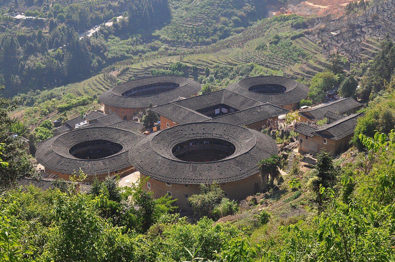
The Fujian Tulou, inscribed by UNESCO in 2008, are 46 distinctive communal fortress residences — circular, square, and polygonal earthen buildings of rammed earth (tulou, 土楼, “earthen building”) built between the 12th and the early 20th centuries by Hakka and Minnan Chinese communities in the mountain valleys of western Fujian Province — whose unique architectural form (massive 3–6-storey rammed-earth perimeter walls enclosing a circular or rectangular courtyard with a communal ancestral hall at centre, housing 100–800 residents of a single clan) combined the functions of a small fortified village, a communal residential compound, and a clan ancestral headquarters in a single structure whose outer wall thickness (1.5–2.5 metres of rammed earth at the base) and single entrance gate provided formidable defensive capability against the banditry and inter-clan warfare that characterised western Fujian’s frontier society from the Song period through the Republican era. The 46 inscribed tulou represent the oldest and architecturally most significant examples of a building type of which approximately 20,000 survive in the western Fujian highland zone; the Chuxi, Tianluokeng, Hekeng, and Gaobei cluster areas selected for inscription were chosen for the variety and integrity they display — circular tulou alongside square ones (the square form being the earlier type), small family clusters alongside the largest surviving example (the Chengqi Lou, “Rising Clouds Building,” Yongding County, 73 metres in diameter, 4 storeys, 400 rooms, 57 units).
Fujian’s mountain interior and the Hakka cultural corridor Wuyi Mountain Fujian · Kaiping Diaolou Guangdong · Gulangyu Xiamen — 100 to 350 km
One Hundred Kilometres northeast of the primary Fujian Tulou cluster areas by road (approximately 2 hours from the Yongding tulou clusters to Xiamen City via the Guangshen Expressway and the Xiamen-Chengdu Expressway G76), Xiamen City is the primary air and rail gateway to the Fujian Tulou. Xiamen Gaoqi International Airport (XMN) serves major Chinese cities and select Southeast Asian routes; Xiamen North Station is on the Fuzhou-Xiamen HSR (approximately 1 hour to Fuzhou, approximately 4 hours to Hangzhou) and will be served by the Xiamen-Shenzhen HSR extension south. Gulangyu Island (鼓浪屿, inscribed as a UNESCO World Heritage Site in 2017 as “a Historic International Settlement”), 600 metres off Xiamen’s coast and accessible by a 7-minute ferry from the Lundu Ferry Terminal, is the most easily combined UNESCO companion to the Fujian Tulou for visitors based in Xiamen: a 1.88-square-kilometre piano-shaped island whose 1903–1949 International Settlement history left a dense collection of Romanesque, Baroque, neo-Gothic, Eclecticist, and Art Deco colonial residential architecture representing the building styles of the British, American, German, French, Japanese, Dutch, Spanish, Portuguese, and Filipino consulates and merchant communities that co-occupied the island alongside the established Minnan Chinese merchant class. Gulangyu’s Shuzhuang Garden (1913), the Kaiyang Mansion (1920s, British Romanesque), and the Bajiao Lou (八角楼, American Colonial octagonal tower, c. 1920) are the best-preserved examples; the entire island is car-free and walkable in 2–3 hours. From the Fujian Tulou clusters (Yongding), Xiamen is reached by coach (approximately 2 hours) or by the Longyan-Xiamen Intercity Railway (Longyan Station accessible by 30-minute bus from Yongding, then 45 minutes to Xiamen North).
One Hundred and Fifty Kilometres northwest of the Fujian Tulou cluster areas by road (approximately 2.5 hours from Yongding to Wuyishan City on the Nanping-Longyan Expressway), Mount Wuyi (Wuyi Mountain, 武夷山, inscribed 1999) is the most directly connected UNESCO natural and cultural site to the Fujian Tulou in terms of the landscape history of western Fujian. The Wuyi Mountain nature reserve (60,000 hectares) contains the best-preserved subtropical forest in East Asia — a UNESCO natural heritage site for its biodiversity (which informed Darwin’s understanding of evolution through the extensive botanical collections made at Wuyi by the 18th–19th-century Jesuit missionaries) and a UNESCO cultural heritage site for the Wuyi Gong palaces and rock-cut tombs (Wuyi boat coffins, suspended wooden coffin planks wedged into cliff crevices 100–300 metres above the valley floor, dating from the Bronze Age, c. 1000–400 BCE, the characteristic burial tradition of the Yue coastal cultural zone) and the Zhu Xi Neo-Confucian academy system (the Zhu Xi Academy, 武夷精舍, founded 1183 CE at the First Bend of the Nine-Bend River). The Wuyi Mountain landscape — a series of 36 red-sandstone (Danxia-type) peaks rising 400–700 metres from the meandering Nine-Bend Creek (Jiuqu Xi) valley — is the characteristic landscape of western Fujian’s mountain interior and provides the visual context for understanding the tulou-building communities’ environment: the Hakka communities built their earthen fortresses in the same red-soil mountain valleys whose Danxia sandstone and tropical forest define the visual character of the Wuyi-Fujian region. From the Fujian Tulou, Wuyi Mountain is reached by coach (approximately 2.5 hours) or by the Wuyishan–Longyani Expressway. Wuyishan has a domestic airport (WUS) with connections to major Chinese cities.
Two Hundred and Fifty Kilometres south of the Fujian Tulou clusters by road (approximately 3.5 hours from Yongding to Kaiping via the Guangshen Expressway south through Guangdong Province, or approximately 3 hours by coach via Shantou), the Kaiping Diaolou and Villages (inscribed 2007) represent the Pearl River Delta’s parallel architectural tradition of the overseas Chinese emigrant community building fortified hybrid Chinese-Western structures in their home villages. The connection between the Fujian Tulou and the Kaiping Diaolou is not only typological (both are defensive communal towers built by communities threatened by banditry and inter-community conflict) but demographic: the Four Counties (Sze Yup) Cantonese emigrants who built the Kaiping Diaolou and the western Fujian Hakka communities who built the Fujian Tulou both participated in the same 19th-century South Chinese emigrant wave to Southeast Asia, North America, and Australia. Many Hakka families from the western Fujian-eastern Guangdong borderland migrated through the same Pearl River Delta ports as the Four Counties Cantonese, and the material comparison between the Hakka earthen fortress tradition (tulou, single clan, single structure enclosing the entire community) and the Kaiping family watchtower tradition (diaolou, individual family, smaller structure serving a defensive function within a village cluster) illustrates the different architectural solutions developed by two adjacent emigrant communities from the same South Chinese cultural background. From the Fujian Tulou, Kaiping is reached by coach via Guangzhou (approximately 4 hours total).
Three Hundred and Fifty Kilometres north of the Fujian Tulou clusters by road and HSR (approximately 1 hour from Longyan by intercity rail to Xiamen North, then approximately 3.5 hours by HSR from Xiamen North to Fuzhou South on the Fuzhou-Xiamen HSR, then approximately 2 hours from Fuzhou to Wuyishan by conventional rail), Fuzhou City — the provincial capital of Fujian — contains the Three Lanes and Seven Alleys (Sanfang Qixiang, 三坊七巷, a 240,000-square-metre preserved Ming-Qing residential quarter in central Fuzhou with more than 200 historic buildings including the Lin Zexu Memorial Hall and the Shen Baozhen Residence) and the Mawei Shipyard (Fuzhou Arsenal, 1866, the first Western-style naval facility in China, established by Zuo Zongtang and Prosper Giquel, where the first generation of Chinese naval engineers were trained by French advisers). Both the Three Lanes and Seven Alleys and the Mawei Shipyard are on China’s Tentative List for UNESCO nomination. From the Fujian Tulou, Fuzhou is most efficiently reached via Xiamen HSR (approximately 1 hour Xiamen North to Fuzhou South).
Southern China’s Buddhist and Confucian mountains and the Southeast Asian diaspora South China Karst Guilin · Ancient Villages Xidi Hongcun · Gulangyu Xiamen — 100 to 450 km
One Hundred Kilometres west of the Fujian Tulou’s western cluster areas (and therefore on the Fujian-Guangdong border), the Chaoshan (Chaozhou-Shantou) area in eastern Guangdong — home of the Teochew (Chaozhou dialect) Chinese community — is the departure region for the largest Southeast Asian Chinese diaspora: the Teochew emigrant communities of Thailand, Malaysia, Cambodia, Vietnam, and Singapore, whose commercial networks dominated Southeast Asian retail trade from the 19th century through the present day. The Chaozhou Kaiyuan Temple (Chaozhou, Tang dynasty, 738 CE, the largest Buddhist temple complex in Chaoshan), the Chaozhou Memorial Archways (Paifang Jie, Ming-Qing period civic archways), and the Hanjiang Corridor (a 1.5-kilometre covered walkway along the Han River in Chaozhou, Qing dynasty) document the Teochew cultural heritage that the Southeast Asian diaspora carried with it. The Teochew community’s cultural relationship to the Fujian Tulou-building Hakka communities is complex — in the western Fujian highlands, Hakka and Teochew communities lived in adjacent valleys and competed for the same highland agricultural resources, which contributed to the inter-community conflict that made the tulou’s defensive design necessary. From the Fujian Tulou’s Yongding clusters, Chaozhou is reached by coach (approximately 3 hours southeast via Dapu County on the G76 Expressway).
Four Hundred Kilometres north of the Fujian Tulou by road and HSR (approximately 4 hours from Xiamen North to Hangzhou East on the Xiamen-Hangzhou HSR, passing through the Fuzhou and Wenzhou urban areas), the West Lake Cultural Landscape of Hangzhou (inscribed 2011) represents the other end of the Fujian geographical corridor — from the Hakka earthen fortress communities of western Fujian’s mountain interior to the refined classical garden and Buddhist landscape of Hangzhou’s lakeside cultural zone, a 10-century tradition of imperial patronage, Buddhist pilgrimage, and literati aesthetics. The West Lake (Xihu) landscape comprises the lake itself (5.6 km²) with its ten classical views (Si Tiao Causeway with weeping willows, Leifeng Pagoda at sunset, Three Pools Mirroring the Moon, and seven others established as the official views in the Southern Song period, 1127–1279 CE, when Hangzhou was the imperial capital of Lin’an), 60 historic structures including temples, towers, memorials, and gardens, and the Su Causeway and the Bai Causeway (built by the Tang poet Su Dongpo, who served as Hangzhou prefect 1089–1091 CE, and the earlier Tang poet Bai Juyi, who served 822–824 CE). From the Fujian Tulou, Hangzhou is reached by the full Xiamen-Hangzhou HSR (approximately 4 hours from Xiamen North to Hangzhou East).
Practical information
The Fujian Tulou UNESCO site comprises 46 individual tulou buildings in multiple cluster areas in Longyan (Yongding County) and Zhangzhou (Nanjing County) prefectures of western Fujian Province. Visitor access is primarily through two cluster zones: the Yongding Tulou cluster (Yongding County, approximately 100 km west of Xiamen, the most visited, containing the Chuxi cluster, the Gaobei cluster with the Chengqi Lou, and the Hongkeng cluster) and the Nanjing Tulou cluster (Nanjing County, approximately 80 km northwest of Zhangzhou City, containing the Tianluokeng “Four Dishes and One Soup” cluster — four circular tulou arranged around one square one, the most photographed tulou composition — and the Hekeng cluster). The UNESCO site admission is combined with the individual cluster entrance fees; tickets are purchased at the cluster entrances. Xiamen is the primary air gateway (XMN, 100 km east of Yongding); Longyan City (the nearest major city to Yongding, 30 km north) has a domestic airport (LCX) with connections to Guangzhou and Shenzhen. The Longyan-Xiamen Intercity Railway (approximately 45 minutes from Longyan to Xiamen North) makes a Xiamen-based tulou visit by day-trip or overnight practical. The Tianluokeng cluster in Nanjing County (the UNESCO poster image) is 1.5 hours by coach from Zhangzhou City and approximately 2 hours from Xiamen by coach via the Zhangzhou-Nanjing Expressway. Best visiting season: March–May (spring, green rice paddies, clear weather) and September–November (autumn harvest, yellow paddy fields); summer (June–August) brings humid heat and typhoon rain risk. Staying overnight in a tulou (several have converted some residential rooms into guesthouses) is recommended for experiencing the communal living atmosphere at dawn and dusk.
Frequently Asked Questions
Who are the Hakka and why did they build such unusual communal fortresses?
The Hakka (客家, Kèjiā, “guest families”) are a Han Chinese subgroup whose identity is defined by historical migration: they are descendants of Han Chinese communities from the Central Plains (the Yellow River basin of Henan, Shanxi, and Shaanxi provinces) who migrated southward in a series of waves between the 4th and 17th centuries, displaced by northern invasions (the Jin dynasty invasion of 317 CE, the Mongol conquest of 1279 CE, and the Ming-Qing transition of the 17th century). Each wave of migration brought Hakka settlers further south — from the Central Plains to the Jiangxi highlands, from Jiangxi to the western Fujian-eastern Guangdong mountain borderland (where the majority of the tulou-building communities settled between the 11th and 15th centuries), and from Fujian-Guangdong to Southeast Asia and the broader diaspora. The Hakka identity is maintained through the Hakka dialect (a conservative Chinese dialect preserving features of Tang-period Mandarin, distinct from Cantonese, Minnan, and other Southern Chinese dialects), the Hakka clan organization system (which maintained the northern Chinese patrilineal clan structure intact through centuries of southern migration), and — most materially — the tulou communal fortress tradition. The tulou were built as defensive responses to the specific insecurity of Hakka settlement in western Fujian’s mountain valleys, where the Hakka migrants (as “guest families” arriving in already settled territory) faced persistent conflict with earlier Minnan and Yao-She indigenous communities over agricultural land, water rights, and commercial access. The tulou’s capacity to house an entire clan (50–800 people of a single surname) in a single defensible structure, with the clan’s grain stores, communal kitchen, ancestral hall, and defensive parapet concentrated in one location, made it the practical architectural solution to the specific combination of external threat (inter-community conflict) and internal social organisation (the clan unit) that characterised Hakka frontier settlement. The same clan-based social organisation that generated the tulou also drove the Hakka emigration to Southeast Asia, North America, and Australia in the 19th century — the Hakka contributed disproportionately to the overseas Chinese populations of Tahiti (approximately 60% Hakka), French Polynesia, and Panama, and include among their diaspora community notable figures such as Sun Yat-sen (whose father’s family was Hakka from Guangdong), Deng Xiaoping (Hakka from Sichuan-Guangdong border area), and Lee Kuan Yew (Singapore’s founding Prime Minister, Hakka from Guangdong).
What is rammed earth (hangtu) construction and how do the Fujian Tulou achieve their structural strength?
Rammed earth (hangtu, 夯土, “pounded soil”) is a construction technique in which layers of moist soil — typically a mixture of local subsoil, sand, limestone, glutinous rice paste, brown sugar, and egg whites (the traditional Fujian tulou recipe, which produces a concrete-like hardness on curing) — are poured into temporary wooden formwork and compacted by mechanical pounding with a heavy wooden tamper until each layer (typically 10–15 cm thick) reaches maximum density. The formwork is then raised and the next layer poured and compacted, progressively building the wall upward at a rate of approximately 1 metre per month. The tulou builders developed a sophisticated understanding of rammed earth’s structural properties: the walls are tapered (typically 1.5–2.5 metres at the base, narrowing to 0.8–1.0 metre at the parapet), which distributes the wall’s own weight optimally and provides a stable foundation for the timber-framed upper-storey structures. The external wall surface is plastered with lime (locally burnt from the abundant limestone of the Fujian mountain zone) and the roof overhang is designed to shed rainwater away from the rammed-earth wall surface — the primary vulnerability of rammed earth being moisture erosion, which can be dramatically accelerated by rainfall infiltration. The structural performance of the oldest surviving tulou — the Yuchanglou in Nanjing County (built c. 1308 CE, the oldest confirmed tulou in the inscribed area) is more than 700 years old and structurally intact despite four unrestored external wall cracks resulting from historical earthquakes — demonstrates the durability of the optimised Fujian rammed-earth recipe under the humid subtropical conditions of western Fujian. The 1.7-magnitude earthquake that struck Nanjing County in 1918 caused cracks in the Yuchanglou but did not destabilise the structure; local accounts record that the cracks “breathe” — opening slightly during dry seasons and closing during wet seasons — accommodating thermal and moisture expansion without structural failure.
Why were the Fujian Tulou mistaken for nuclear missile silos by American intelligence agencies?
The Fujian Tulou’s designation as a cultural heritage site has an unusual intelligence history: during the early period of satellite reconnaissance of China in the 1960s, CIA photo analysts examining high-resolution images of western Fujian’s mountain valleys initially classified the large circular earthen structures as likely nuclear missile silo complexes — an interpretation that caused brief alarm before further analysis determined they were domestic structures. The misidentification was the result of the tulou’s visual profile in overhead satellite imagery: a large circular earthen structure (the Chengqi Lou, the largest surviving tulou, is 73 metres in diameter — approximately the same footprint as a large Soviet SS-18 ICBM silo complex as visible from satellite altitude), with a single entrance gate and thick perimeter walls showing no windows at the lower levels (the ground floor windows of most tulou are narrow defensive slots rather than standard apertures). The visual resemblance to a hardened military installation was superficially convincing to photo analysts who had no information about the tulou tradition. The misidentification was resolved when subsequent analysis confirmed that the structures contained visible agricultural activity, residential use, and vegetable gardens in the inner courtyard areas, and when Chinese defector interviews confirmed that the circular earthen structures of western Fujian were traditional communal dwellings rather than military installations. The anecdote is often cited in media coverage of the Fujian Tulou UNESCO inscription as evidence of how unfamiliar the tulou tradition was outside the Hakka diaspora before the 1990s: despite the 20,000+ surviving tulou in western Fujian, the building type was essentially unknown internationally until the UNESCO nomination process began in the early 2000s and the first substantial English-language architectural monographs were published.
Sources
- S1 — UNESCO World Heritage Centre — Fujian Tulou (Ref. 1113) — https://web.archive.org/web/20230601000000/https://whc.unesco.org/en/list/1113/
- S2 — UNESCO World Heritage Centre — Statement of Outstanding Universal Value (Ref. 1113) — https://whc.unesco.org/en/list/1113/
Spotted an error? Write to editorial@culturalheritageonline.com and we correct it the same day.