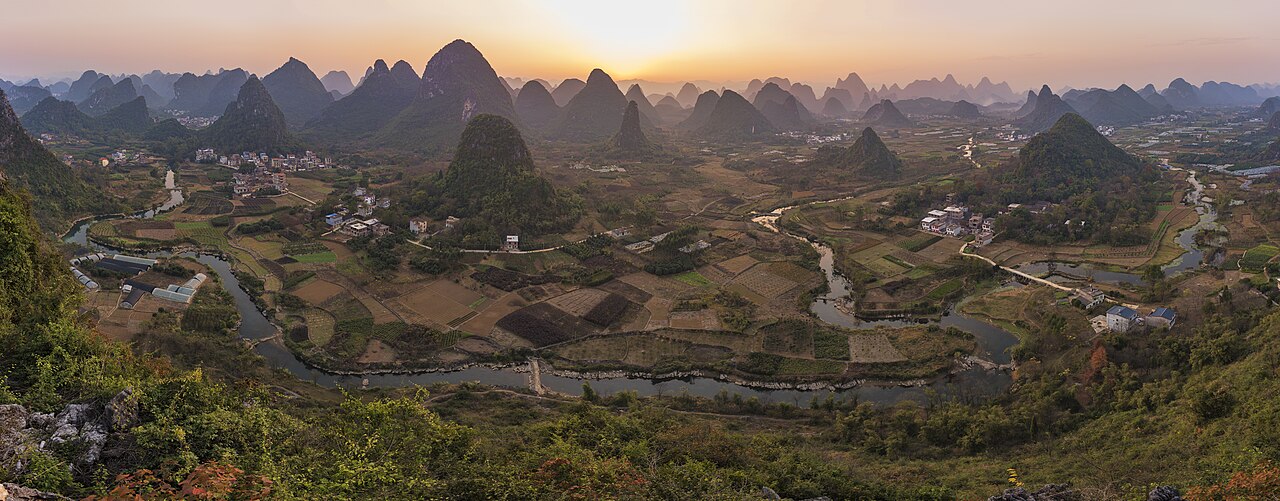
The South China Karst, inscribed by UNESCO in 2007 and extended in 2014, protects the most complete and scientifically significant example of tropical and subtropical karst landscape in the world: six component areas (Shilin Stone Forest in Yunnan, Libo Karst in Guizhou, Guilin Karst in Guangxi, Shibing Karst in Guizhou, Huanjiang Karst in Guangxi, and Jinfoshan Karst in Chongqing) demonstrating the full sequential and geographic range of karst geomorphological forms — stone forest (fengcong or “cone karst”), tower karst (fenglin), peak forest, and the Shilin pinnacle karst (“stone forest”) that represents an extreme form of karst dissolution found at only two other locations globally. The inscription’s Outstanding Universal Value rests on the progressive representation of karst landform development across all six components: from the needle-like stone pinnacles of Shilin (the most extreme limestone dissolution form, where dissolution has reduced the original limestone plateau to a landscape of stone blades up to 30 metres high and 3–10 metres apart) through the conical hill-and-depression landscape of Libo (fengcong depression karst, where isolated limestone cones 200–500 metres high rise from a terrain of closed depressions, dolines, and poljes drained by underground stream systems) to the tower karst of Guilin and Yangshuo (fenglin or “peak forest” landscape, where individual limestone towers 200–300 metres high rise in isolation from a flat alluvial valley floor), which represents the most advanced stage of karst plain development and is the landscape archetype of classical Chinese landscape painting, appearing on the 20-yuan Chinese renminbi banknote in its Xingping Li River incarnation.
The Guangxi karst landscape and the Li River visual tradition Kaiping Diaolou Pearl River Delta · Three Parallel Rivers Yunnan · Longmen Grottoes Henan — 300 to 900 km
Three Hundred Kilometres southeast of the South China Karst’s Guilin/Guangxi component by high-speed rail (approximately 2 hours from Guilin North Station to Guangzhou South on the Guiyang-Guangzhou HSR, opened 2014), the Pearl River Delta’s UNESCO heritage circuit — the Historic Centre of Macao (inscribed 2005, 140 km south of Guangzhou) and the Kaiping Diaolou (inscribed 2007, 100 km west of Guangzhou) — is the most efficiently accessed companion circuit to the Guilin karst. The hydrological connection between the South China Karst and the Pearl River Delta is direct: the Gui River (which drains the Guilin karst through the Li River gorge to Yangshuo, then continues south as the Gui River to join the West River at Wuzhou) is the primary upstream tributary of the West River (Xijiang), which flows through the Kaiping agricultural landscape past the diaolou towers before entering the Pearl River estuary at Guangzhou. Visitors combining the Guilin karst with the Pearl River Delta sites can use the Guiyang-Guangzhou HSR as the connecting axis: Guilin North to Guangzhou South (approximately 2 hours) for the Kaiping and Macao circuit, or the reverse (Guangzhou South to Guilin North) as a 2-night extension from Hong Kong or Guangzhou. Yangshuo (55 km south of Guilin on the Li River, accessible by boat from Guilin City Pier, approximately 4 hours, or by bus, 1.5 hours) is the most practical karst-landscape base for multi-day visits: the 10-kilometre Yangshuo West Street heritage quarter, the Yulong River cycling route (18 km circuit through the most photogenic paddy-field-and-karst landscape), and the Xingping village (the most cinematically isolated river karst section, 28 km north of Yangshuo by bus, the landscape depicted on the 20-yuan note) are all accessible from Yangshuo without returning to Guilin.
Six Hundred Kilometres southwest of the South China Karst’s Guilin component by road (approximately 6 hours by coach from Guilin to Guiyang on the Guiyang-Guangzhou HSR in reverse, then approximately 4 hours from Guiyang to Libo County), or approximately 3.5 hours by HSR from Guilin North to Guiyang North (Guiyang-Guangzhou HSR) and then 3 hours by coach to Libo, the Libo Karst component of the South China Karst inscription represents the fengcong depression (“cone karst”) type that UNESCO designated as scientifically distinct from and complementary to the Guilin tower karst. The Libo Karst in Guizhou Province (Zhangjiang Scenic Area, Libo County) covers 29,518 hectares of isolated limestone cones 100–500 metres high rising from a terrain of closed depressions (tiankengs) and underground stream systems; the Zhangjiang River and its tributaries flow through a network of cave systems, underground lakes, and resurgence springs that drain the closed depression system. The Libo area is remote (limited high-speed rail access before the Guiyang-Nanning HSR is fully operational) and receives far fewer visitors than the Guilin component, making it the wilderness complement to Guilin’s heavily visited tourist circuit. From Guilin, Libo is reached by HSR to Guiyang (approximately 3 hours) and then coach (approximately 3–4 hours); or from Guangzhou by the Guiyang-Guangzhou HSR all the way to Guiyang (approximately 4 hours) and then coach. The Maolanshan National Nature Reserve, adjacent to the Libo Karst, contains the best-preserved subtropical evergreen forest in the central-south China karst zone, including the Maolan karst forest (the world’s largest karst forest, more than 200 square kilometres of intact subtropical vegetation growing on exposed limestone terrain) and significant wildlife including the Asian black bear and the clouded leopard.
Four Hundred Kilometres northeast of the South China Karst’s Guilin component by HSR (approximately 3.5 hours from Guilin North to Zhangjiajie West on the Zhangjiajie-Changsha-Guilin HSR, under construction, or currently approximately 8 hours by conventional rail via Huaihua), the Wulingyuan Scenic Area in Hunan Province (inscribed 1992) — not part of the South China Karst inscription but a quartzite sandstone landscape superficially similar — provides the most visually dramatic quartzite pillar landscape in China and is the geological and scenic comparison site for understanding the South China Karst’s limestone-specific geomorphology. The Wulingyuan sandstone pillars (the “Avatar Mountains” of the Zhangjiajie National Forest Park, the landscape used as a reference for the Pandora planet’s Hallelujah Mountains in James Cameron’s Avatar, 2009) are produced by a different geological process from the karst: these are quartz sandstone columns eroded by physical weathering and river incision from a Devonian sandstone plateau, not dissolved limestone. The visual result — vertical pillars 200–400 metres high rising from flat valley floors — superficially resembles the South China Karst’s tower karst at Guilin, making the comparison instructive for understanding the difference between karst dissolution and physical erosion in producing similar-looking landscapes from different rock types. From Guilin, Zhangjiajie is currently most efficiently reached by flight (Guilin Liangjiang Airport to Zhangjiajie Hehua Airport, approximately 1.5 hours) or by the Zhangjiajie-Changsha-Guilin HSR when fully operational.
Ninety Kilometres east of the South China Karst’s Shilin Stone Forest component (Shilin Scenic Area, approximately 90 km southeast of Kunming, accessible by metro Line 5 and suburban rail from Kunming to Shilin Station, approximately 1.5 hours), Kunming City in Yunnan Province is the regional transport hub for the South China Karst’s Yunnan component. The Shilin Stone Forest covers 350 square kilometres of which 12 square kilometres are the visitor-accessible “Greater Stone Forest” (Dashipin) and “Lesser Stone Forest” (Xiaoshipin) scenic areas: limestone needle formations 10–30 metres high, separated by walkable pathways of 1–3 metres width, producing a labyrinthine environment where the overriding impression is of being within a dense forest of grey-black stone blades. The Sani people (a branch of the Yi ethnic minority, historically resident in the Shilin area) have maintained a traditional relationship with the stone forest landscape that is reflected in the Sani oral epic “Ashima” — a Sani legend in which the stone formation is the petrified body of a Sani woman (Ashima) who was turned to stone after refusing to abandon her ancestral home when forced to marry against her will — creating an indigenous cultural narrative that frames the geological formation as a mythological landscape rather than purely a natural phenomenon. From Kunming, the Three Parallel Rivers’ Lijiang component (Tiger Leaping Gorge, 250 km northwest of Kunming) is accessible by HSR (Kunming South to Lijiang South, approximately 2.5 hours) as a 2-day extension from the Shilin circuit.
The karst highlands of south China and the Yangtze river basin Dazu Rock Carvings Chongqing · Huanglong Sichuan · Mount Emei Leshan — 400 to 600 km
Four Hundred and Fifty Kilometres northeast of the South China Karst’s Libo Guizhou component by road and HSR (approximately 3 hours from Guiyang North to Chongqing North on the Chengdu-Guiyang HSR, with connection from Libo to Guiyang by coach 3 hours), the Dazu Rock Carvings in Chongqing Municipality (inscribed 1999) are the nearest major UNESCO site in the Yangtze River basin to the South China Karst’s Guizhou components. The Dazu district’s location at the edge of the Sichuan Basin’s red sandstone bedrock — the Jurassic and Cretaceous red-bed sandstone that gives the Sichuan Basin its characteristic red soils and that weathers into the rounded hills (rather than the vertical karst forms of Guizhou-Guangxi) around Chongqing — provides a geological contrast with the South China Karst’s limestone dissolution landscape that clarifies the role of rock type in landscape formation. From the South China Karst’s Guilin component, Chongqing is reached by HSR (Guilin North to Guiyang North to Chongqing on the Chengdu-Guiyang HSR, approximately 5 hours total), or by the Yunnan-Guizhou-Chongqing expressway from the Libo component (approximately 5 hours). From Chongqing, Dazu Rock Carvings are reached by HSR to Dazu North Station (approximately 45 minutes) and bus to Baoding Mountain (approximately 30 minutes).
Five Hundred Kilometres northwest of the South China Karst’s Guizhou-Chongqing components by road (approximately 6 hours from Chongqing to Chengdu by road or approximately 1.5 hours by HSR from Chongqing North to Chengdu East), the Sichuan Giant Panda Sanctuaries (inscribed 2006) and the Mount Emei Scenic Area and Leshan Giant Buddha (inscribed 1996) form the western terminal of the Yangtze River basin heritage circuit. The South China Karst’s Jinfoshan component (Jinfo Mountain, Nanchuan County, approximately 150 km southeast of Chongqing) is the closest karst component to Sichuan and represents the cold-water karst variant (alpine karst at 2,200 metres altitude, with ice cave formations) in contrast to the tropical karst of the Guilin and Libo components. From Chongqing, the Jinfoshan component is accessible by coach (approximately 3 hours to Nanchuan) and is commonly visited as a day or overnight extension from the Chongqing-Dazu circuit before continuing to Chengdu by HSR.
Practical information
The South China Karst is a serial inscription covering six geographically separate components in four Chinese provinces: Shilin (Stone Forest, Yunnan), Libo (Guizhou), Guilin (Guangxi), Shibing (Guizhou), Huanjiang (Guangxi), and Jinfoshan (Chongqing). Visitors typically focus on one or two components per trip; the Guilin/Yangshuo component in Guangxi is by far the most visited and the best served by tourist infrastructure. Guilin Liangjiang International Airport (KWL) has direct flights from major Chinese cities and some international routes; Guilin North Station is on the Guiyang-Guangzhou HSR (approximately 2 hours to Guangzhou South, approximately 3.5 hours to Guiyang for the Libo circuit). The Li River cruise from Guilin to Yangshuo (operated daily, booking through official channels required in peak season, April–October, approximately 4 hours, approximately CNY 210–498 depending on class) is the primary visitor experience; tickets should be booked 1–2 days in advance in the April–May and September–October peak periods. Yangshuo (55 km south of Guilin by bus, 1.5 hours) offers a full range of accommodation and is the recommended base for multi-day karst landscape visits. For the Shilin Stone Forest (Yunnan component), Kunming is the base and Shilin is reached by metro and suburban rail (approximately 1.5 hours); the Stone Forest is feasible as a day trip from Kunming. The Libo component requires overnight stays in Libo County town and is recommended only for visitors with at least 5 days in the South China Karst region who specifically want to see the fengcong depression karst landscape in its intact wilderness setting. The best visiting season for Guilin-Yangshuo is April–May and September–October; rainy season (June–August) brings flooding that sometimes suspends the Li River cruise.
Frequently Asked Questions
What is karst and how does the South China Karst differ from karst landscapes in Europe and the Caribbean?
Karst (from the German and Slovenian word for the limestone plateau north of Trieste, first described scientifically by the geologist Jovan Cvijić in 1893) is the collective term for landforms produced by the chemical dissolution of soluble rocks — primarily limestone (calcium carbonate, CaCO₃), but also dolomite, gypsum, and salt — by slightly acidic water. Rainwater naturally absorbs carbon dioxide from the atmosphere and soil to form weak carbonic acid (H₂CO₃), which dissolves limestone by the reaction CaCO₃ + H₂CO₃ → Ca(HCO₃)₂ (calcium bicarbonate, soluble), progressively enlarging natural fractures and bedding planes into caves, caverns, sinkholes, and underground stream systems. The landscape visible above ground — the towers, pinnacles, and depressions of the South China Karst — is the residual solid limestone not yet dissolved, while the missing limestone volume has been carried away in solution by groundwater. The South China Karst differs from European karst (the Alps, the Dinaric Alps, the Causses of France, the Yorkshire Dales) and Caribbean karst (the cockpit country of Jamaica, the mogotes of Puerto Rico and Cuba) primarily in its climate-driven dissolution rate: the South China Karst’s tropical and subtropical monsoon climate produces dissolution rates 2–4 times faster than the temperate climate zones, creating taller, more isolated towers and deeper sinkholes than are found in cooler climates. The Guilin tower karst’s individual limestone peaks (200–300 metres high, standing in isolation on a flat alluvial plain) represent an advanced stage of dissolution that is not found in European karst — the Dinaric karst’s poljes and blind valleys represent an earlier stage of the same dissolution sequence, before the limestone had been reduced to isolated towers. The UNESCO inscription explicitly values the South China Karst as the most complete representation of the full karst geomorphological sequence, from the earliest pinnacle karst stages (Shilin Stone Forest) through mature tower karst (Guilin) — a developmental sequence that no single European karst landscape presents in comparable completeness.
What is the Li River cruise and how was the landscape in the Li River Gorge formed?
The Li River (Lijiang, 漓江, “beautiful river”) cruise from Guilin to Yangshuo (approximately 83 kilometres, navigated by flat-bottomed tourist boats in 3.5–4.5 hours) passes through the densest concentration of tower karst (fenglin, “peak forest”) in the Guilin inscribed component: approximately 300 individual limestone peaks of 100–400 metres height visible from the river, most rising directly from the alluvial floodplain at river level. The Li River Gorge was formed by the same dissolution and incision process that formed the surrounding karst landscape, but with an additional fluvial component: the Li River’s southward course through the Guilin basin first dissolved the limestone along a major north-south tectonic joint system (creating a line of weakness through the otherwise massive limestone), then progressively deepened its course by mechanical erosion (cutting a valley floor) while the adjacent limestone dissolved laterally into the tower forms visible today. The flat alluvial plain that surrounds the towers at Guilin and Yangshuo is not ancient valley floor but Quaternary alluvial deposits (silts and gravels brought down by the Li River and its tributaries during seasonal flooding), filling the gaps between the towers to the base level that the river maintains today. The towers appear to “rise from” the flat plain because the alluvium has buried the base of the karst massif to a depth of 20–50 metres below the plain surface — the towers’ bases continue underground. The most photographed section of the Li River cruise is the Xingping sector (approximately 60 km south of Guilin), where the peaks are most densely concentrated and the Jiu Ma Hua Shan (“Nine Horses Fresco Hill,” a cliff face with erosion patterns resembling mounted horses) and the Yellow Cloth Shoal (a shallow river crossing where the mountains’ reflections in the water mirror the Chinese 20-yuan note’s design) are the principal scenic highlights. The best light on the Li River is in early morning (approximately 7:00–9:00 am) and late afternoon (approximately 4:00–6:00 pm); the cruise’s 4-hour midday schedule misses both golden-light windows, making early-morning private boat charters or the Yulong River day hike south of Yangshuo (which allows flexibility of timing) preferable for serious photography.
How does the South China Karst relate to the classical Chinese landscape painting tradition and why is the Li River specifically depicted on the 20-yuan banknote?
The relationship between the Guilin karst landscape and the Chinese landscape painting (shanshui, 山水, “mountain-water”) tradition is one of the most direct cases in world art history where a specific geographical location generated and sustained a major aesthetic tradition for more than 1,000 years. The earliest known landscape paintings in the Chinese tradition (Tang dynasty, 618–907 CE) use brushwork conventions — vertical strokes for peaks, horizontal washes for water, graduated ink for atmospheric depth — that correspond to the visual properties of the Guilin karst more precisely than to any other landscape type: the individual limestone towers’ vertical profiles translate naturally into single bold brush strokes, the flat alluvial plain between the peaks provides the horizontal register for water-wash techniques, and the monsoon mists that regularly fill the Guilin valley create the graduated atmospheric depth that is the defining feature of Song-dynasty (960–1279 CE) landscape painting’s “misty mountain” aesthetic. The Song-period landscape painters Guo Xi (c. 1020–1090 CE) and Fan Kuan (c. 990–1020 CE) developed the formal vocabulary of the shanshui tradition — the “dragon-vein” mountain composition (long horizontal S-shaped mountain ridges with vertical spurs), the “three-distance” perspective system (high-distance for looking up to peaks, level-distance for looking across plains, deep-distance for looking into valleys) — that is standardly interpreted as reflecting the Guilin-type tower karst landscape geometry, though neither painter is documented to have visited Guilin specifically. The 20-yuan renminbi banknote’s Li River karst design (the Xingping section of the Li River at the bend near Xingping Town, selected in 1987 when the fourth series of renminbi was designed) reflects the Chinese government’s selection of the Guilin karst as the national landscape symbol most universally recognised as representing China’s natural heritage — the shanshui painting tradition having made the tower-karst-reflected-in-water composition the single most replicated landscape image in Chinese visual culture for more than 1,000 years.
Sources
- S1 — UNESCO World Heritage Centre — South China Karst (Ref. 1248) — https://web.archive.org/web/20230601000000/https://whc.unesco.org/en/list/1248/
- S2 — UNESCO World Heritage Centre — Statement of Outstanding Universal Value (Ref. 1248) — https://whc.unesco.org/en/list/1248/
Spotted an error? Write to editorial@culturalheritageonline.com and we correct it the same day.