
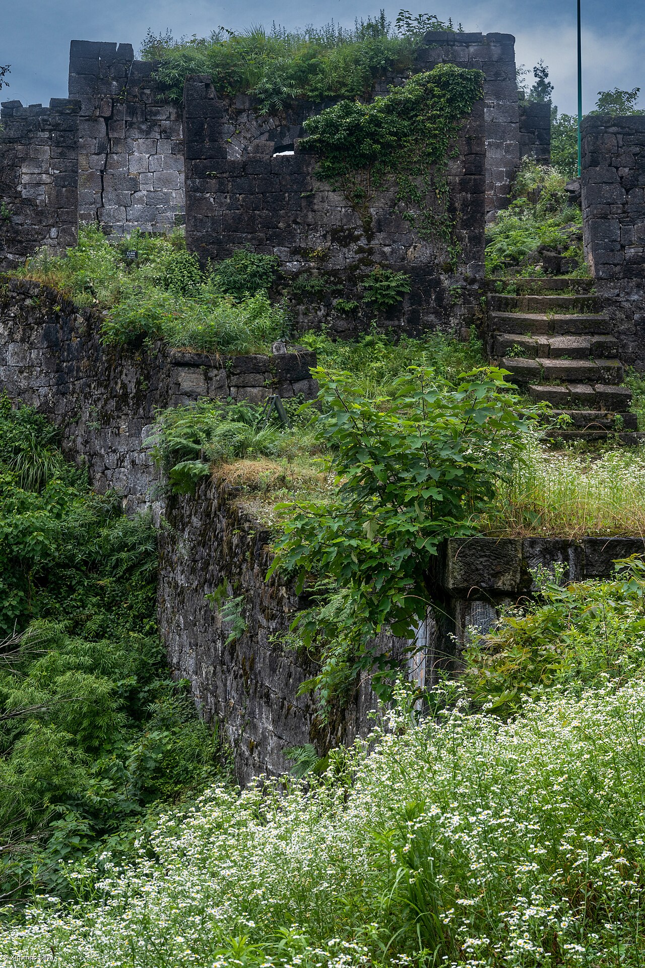
The Tusi Sites, inscribed as UNESCO World Heritage in 2015, consist of three separate chieftain seat complexes that document the tusi system, a Yuan- and Ming-dynasty administrative arrangement in which non-Han hereditary lords governed China’s southwestern border regions under nominal imperial authority from the thirteenth century until 1911. The three components are Laosicheng in Yongshun, Hunan Province (a fortified chieftain city active from 1135 to 1728 CE), Hailongtun fortress on a clifftop in Zunyi, Guizhou Province (the seat of the Yang clan tusi, besieged and destroyed by Ming imperial forces in 1600 CE after a 114-day campaign), and Tangya in Enshi, Hubei Province (a tusi seat of the Tian clan active from the Song to the Qing dynasty). Together they span three provinces across the upper Yangtze basin and are positioned within a day’s travel of four additional UNESCO World Heritage sites covering the geology, Buddhist rock art and Taoist mountain architecture of the same region.
From Laosicheng: Wulingyuan and Wudang Mountains Wulingyuan/Zhangjiajie 250 km east of Laosicheng, 3h by road; Wudang Mountains 500 km north of Laosicheng, 5h by road or train
Wulingyuan Scenic Area in western Hunan Province, inscribed as UNESCO World Heritage in 1992, is approximately 250 kilometres east of Laosicheng in Yongshun, reachable in approximately 3 hours by road via the Yongshun–Zhangjiajie expressway. Wulingyuan encompasses 264 square kilometres of sandstone and quartz pillar formations, comprising more than 3,000 individual pillars — the tallest reaching 400 metres — along with 40 limestone caves, 2 natural bridges and 800 streams within the area administered across three scenic zones (Zhangjiajie National Forest Park, Suoxiyu Nature Reserve and Tianzi Mountain Nature Reserve). The sandstone pillars, formed through the erosion of Devonian-period (approximately 380 million years ago) quartz arenite by water and frost action over tens of millions of years, were eroded into their current isolated columnar forms partly because the rock mass is heavily jointed but resistant to chemical weathering. The Laosicheng tusi seat at Yongshun is set in the same Wuling Mountains geological province as Wulingyuan, sharing the same karst and sandstone landscape context; the Tujia people (tujiazu), who were the ethnic group administered by the tusi system at Laosicheng from at least the Song dynasty, are the predominant ethnic group in the Zhangjiajie area today, giving the connection between Laosicheng and Wulingyuan a continuous human geographic logic as well as a physical one. Zhangjiajie City (the urban centre adjacent to Wulingyuan) is connected to Changsha by high-speed rail in approximately 2 hours; Yongshun is connected to Zhangjiajie by road in approximately 1.5 hours. Combined Laosicheng–Wulingyuan visits are most efficiently organised by basing in Zhangjiajie City (1.5 hours from Laosicheng, 30 minutes from Wulingyuan) for 2 to 3 days, with Laosicheng as a half-day or full-day excursion.
The Ancient Building Complex in the Wudang Mountains, inscribed as UNESCO World Heritage in 1994, is approximately 500 kilometres north of Laosicheng in Yongshun, reachable in approximately 5 hours by road via Zhangjiajie and the G5513 Expressway to Shiyan in Hubei Province, or by a combination of rail and road (Yongshun to Zhangjiajie by road, then overnight train from Zhangjiajie toward Wuhan with a change at Xiangfan or Shiyan). The Wudang Mountains (Wudangshan) inscription covers a complex of Taoist religious buildings constructed between the 7th and 19th centuries on the Wudang massif in Shiyan, Hubei Province, comprising 72 cliffs and peaks integrated with temple buildings, palaces, bridges and city walls. The dominant structure is the Purple Cloud Palace (Zixiao Gong) built under the Yongle Emperor of the Ming dynasty in 1413–1424 CE, part of a coordinated construction programme ordered by Emperor Yongle to honour the Taoist deity Xuantian (the True Warrior), whom Yongle credited with assisting his military usurpation of the throne (the Jingnan campaign, 1399–1402 CE). The UNESCO inscription covers 53 individual buildings; the Golden Hall at the summit of Tianzhu Peak (1,612 metres), cast in gilded bronze in 1416 CE and prefabricated in Beijing before transport and assembly on the mountain, is the defining image of the site. The connection between Wudang and the Laosicheng tusi system lies in overlapping chronology: the Yongle Emperor’s construction of Wudang (1413–1424 CE) coincided with the active phase of the Laosicheng tusi seat and the broader Ming imperial project of integrating the southwestern chieftains into the imperial ceremonial and religious order, even as the tusi were permitted to retain hereditary authority over their local populations.
From Hailongtun: Dazu Rock Carvings and South China Karst at Wulong Dazu 500 km northwest of Hailongtun, 5h HSR via Chongqing; Wulong Karst 200 km northeast of Hailongtun, 2.5h by road
The Dazu Rock Carvings in Chongqing Municipality, inscribed as UNESCO World Heritage in 1999, are approximately 500 kilometres northwest of Hailongtun in Zunyi, Guizhou, reachable in approximately 5 hours by high-speed rail via the Guiyang–Chongqing HSR line (Zunyi North to Chongqing North, approximately 2.5 hours) followed by a bus or taxi to Dazu District (approximately 1.5 to 2 hours from central Chongqing). The Dazu inscription covers 75 sites containing approximately 50,000 sculpted figures and more than 100,000 Chinese characters of inscriptions carved into the cliffs and rock faces of Dazu between the late Tang dynasty (892 CE) and the Song dynasty (thirteenth century CE). The two principal sites open to visitors are Beishan (North Mountain), the earlier grouping (begun 892 CE) of approximately 264 niches cut into a 300-metre cliff face, and Baoding Mountain (Baodingshan), a C-shaped valley of 31 groupings carved under the direction of the Buddhist monk Zhao Zhifeng between 1179 and 1249 CE. The Baodingshan carvings are unusual in Chinese Buddhist sculpture for their sequential narrative organisation: the 31 groupings form a continuous thematic circuit in the order Zhao Zhifeng designed for pilgrims to follow, covering the cycle of rebirth, Buddhist parables, Pure Land iconography, and scenes of Confucian filial piety and moral conduct integrated with Buddhist doctrinal content. The connection between Dazu and the Hailongtun tusi fortress is partly territorial: the Yang clan tusi whose seat at Hailongtun was destroyed by the Ming in 1600 CE had originally governed territory in the Zunyi area that extended toward the Chongqing basin where Dazu is located, and the Buddhist practice the Dazu carvings represent was the dominant religious framework across the region the tusi administered.
The South China Karst, inscribed as UNESCO World Heritage in 2007 (Phase I) and 2014 (Phase II), includes the Wulong Karst cluster in Chongqing Municipality approximately 200 kilometres northeast of Hailongtun in Zunyi, reachable in approximately 2.5 hours by road via the Guizhou–Chongqing border area (G75 Lanhai Expressway to Wulong County). Wulong County’s karst features designated in the inscription include the Three Natural Bridges (Sanqiao) — three massive limestone natural bridges, the largest with a span of 281 metres, a width of 30 metres and a clearance height of 223 metres, formed when the roofs of underground river caverns collapsed as the Furong River cut progressively deeper into the Ordovician limestone plateau — and Furong Cave, a single cavern 2,369 metres long with a cross-section reaching 70 metres high and 50 metres wide, containing calcite formations including cave coral, moonmilk deposits and a 10-metre high stalactite column. The South China Karst inscription is the largest and most geologically diverse karst UNESCO inscription in the world, covering six clusters across Guizhou, Chongqing, Yunnan and Guangxi provinces that together document the complete sequence of karst landform development from fengcong (peak cluster) and fenglin (peak forest) formations to tower karst, cone karst and tiankengs (collapsed dolines). The Guizhou Province geology is shared between the Hailongtun tusi site and the Wulong cluster: the Zunyi area where Hailongtun sits is built on the same Ordovician and Cambrian limestone formations that produce the karst features of the South China Karst inscription, giving a direct physical substrate connection between the two sites.
Practical information
The three Tusi Sites are spread across three provinces with no single efficient base. For Laosicheng in Yongshun, Hunan, the nearest city with high-speed rail access is Zhangjiajie (1.5 hours by road), which has HSR connections to Changsha (2 hours) and connections to the national network. For Hailongtun in Zunyi, Guizhou, Zunyi North Station has high-speed rail to Guiyang North (40 minutes) and to Chongqing North (2.5 hours). Guiyang is the primary hub for Guizhou Province with flights and HSR connecting to Beijing (4 hours), Shanghai (4 hours), Guangzhou (2.5 hours) and Kunming (2 hours). For Tangya in Enshi, Hubei, Enshi Railway Station has high-speed rail connections to Wuhan (2.5 hours). Each component site requires a separate visit; combining all three in a single itinerary requires at least 5 to 7 days and significant overland travel. Hailongtun is the most physically dramatic of the three: the fortress sits on a clifftop accessible only by a steep staircase of several hundred steps, and the ruined walls (the site was never rebuilt after the 1600 Ming siege) are spread across a summit area 1,500 metres long by 300 metres wide. Entrance to Hailongtun costs approximately 80 CNY and the ascent takes approximately 45 minutes. Laosicheng entrance is approximately 100 CNY. Spring (April to May) and autumn (September to November) are recommended for all three locations; summer is extremely humid across the Guizhou and Hunan interior, with temperatures reaching 35°C and frequent heavy rainfall.
Frequently Asked Questions
What was the tusi system and why did it eventually end?
The tusi system (tusi zhidu, also translated as “native chieftain system” or “indigenous official system”) was an administrative arrangement first formalised under the Yuan dynasty (1271–1368 CE) and extended under the Ming (1368–1644 CE) and Qing (1644–1912 CE) dynasties to govern non-Han ethnic minority populations in the southwest, northwest and south of the Chinese empire. Under the system, hereditary local leaders (tusi, literally “native officials”) were recognised by the imperial government with official titles, seals and ranks in the Chinese bureaucratic hierarchy, and were granted authority to administer their territories, collect taxes and field military forces on behalf of the emperor, in exchange for tribute payments and nominal submission to imperial law. The system allowed the central state to extend nominal sovereignty over territories and populations it lacked the administrative capacity or military resources to govern directly, while leaving effective power in the hands of locally legitimate hereditary rulers. The hereditary nature of tusi offices meant that succession disputes and power concentrations within individual tusi lineages regularly produced instability; the Ming dynasty’s destruction of Hailongtun in 1600 CE (after a 114-day siege requiring the mobilisation of forces from multiple provinces) was the largest single military operation in the campaign to reduce overpowerful tusi. The Qing dynasty pursued a policy of gaitu guiliu (“converting tusi to regular government,” replacing hereditary tusi offices with appointed and rotated regular bureaucrats) that gathered pace in the 18th century; the Yongzheng Emperor’s reforms of the 1720s and 1730s replaced tusi administration across large areas of Guizhou, Hunan, Sichuan and Yunnan. The last formal tusi offices were abolished in 1911 with the fall of the Qing dynasty, ending a system that had administered China’s multiethnic southwestern frontier for approximately 600 years.
How did the 114-day Ming siege of Hailongtun end, and what happened to the Yang clan tusi?
The siege of Hailongtun in 1600 CE was the climax of the military campaign known as the Bozhou Campaign, one of the “Three Great Campaigns” of the Wanli Emperor’s reign (the other two being the Korean campaign against the Japanese invasion and the Ningxia Muslim rebellion). The Yang clan had administered the Bozhou chieftaincy in what is now northern Guizhou Province for 29 generations, approximately 700 years from the late Tang dynasty through the Ming, and had accumulated sufficient territory, wealth and military capacity to pose what the Ming court regarded as an unacceptable challenge to imperial authority. Yang Yinglong, the 29th Yang tusi, launched an open rebellion in 1598 CE after disputes over territorial boundaries and imperial taxation; the Ming court mobilised a reported 240,000 troops under the command of Li Hualong, Governor-General of Sichuan and Guizhou, and encircled Hailongtun fortress beginning in February 1600. The fortress, built on a clifftop with nine successive gate complexes along the only approach path, held for 114 days; the final fall on 24 June 1600 CE occurred when defenders broke through the encircling force in a sally rather than being taken by frontal assault. Yang Yinglong died during or immediately after the fall of the fortress; Ming sources record that he hanged himself inside the fortress, but alternative accounts suggest he died in combat. His sons were captured and executed in Beijing. The fortress was deliberately demolished after the victory; only the stone foundations and gate structures, the walls and some of the carved decorative elements survived and are visible today. The Bozhou territory was divided between two newly created regular administrative counties, Zunyi and Pingyue, governed by appointed officials, permanently ending the hereditary Yang chieftaincy.
What distinguishes Laosicheng from the other two Tusi Site components, and what survives there?
Laosicheng (“Old Chieftain City”) in Yongshun County, Hunan Province, is the largest and oldest of the three Tusi Site components, covering approximately 25 square kilometres of fortified urban remains along the Youshui River. It was the capital of the Pengjiasi (Peng family Tusi) administration, whose documents record continuous occupation from 910 CE (late Tang dynasty) until 1728 CE, when the Qing Yongzheng Emperor’s gaitu guiliu reforms abolished the Peng family chieftaincy and converted the territory to regular county administration. The Peng family tusi administered a population documented in Ming-period tribute records as predominantly Tujia ethnicity, governed by a hierarchical system of subordinate chieftaincies (anfu, xuanfu, xuanwei) beneath the main Pengjiasi seat. What survives at Laosicheng is primarily the urban infrastructure: the city walls (covering approximately 1.7 kilometres of the original perimeter), the foundations and ruins of the palace complex (a complex of courtyards and halls whose layout follows Chinese imperial palace conventions in miniature), subsidiary residential compounds, a military training ground, and the graves of several Peng family tusi. The survival of Laosicheng’s urban fabric distinguishes it from the other two components: Hailongtun was deliberately demolished by the Ming in 1600 and was never resettled, leaving only ruins; Tangya in Enshi retains some above-ground architecture but covers a smaller area. Laosicheng’s 818 years of continuous administrative function (910–1728 CE) documented in the Peng family genealogical records (some of which survive in local archives) make it the best-documented example of tusi governance in the UNESCO inscription, and the site preserves the spatial organisation of a functioning minority-administered city within the Ming imperial order in more detail than any comparable site in China.
Sources
- S1 — UNESCO World Heritage Centre — Tusi Sites (Ref. 1474) — https://web.archive.org/web/20230601000000/https://whc.unesco.org/en/list/1474/
- S2 — National Cultural Heritage Administration China — https://whc.unesco.org/en/list/1474/
- S3 — Kuhn, Dieter. <em>The Age of Confucian Rule: The Song Transformation of China</em>. Harvard University Press, 2009. ISBN: 978-0-674-03661-1.
Spotted an error? Write to editorial@culturalheritageonline.com and we correct it the same day.
.jpg)