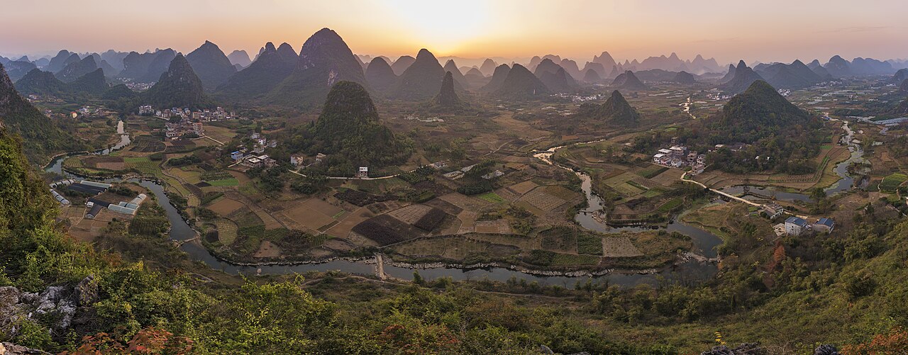
The South China Karst was inscribed as UNESCO World Heritage in 2007 and extended in 2014 to cover four sub-types of karst landscape across three provinces: the Stone Forest (Shilin) near Kunming in Yunnan, the cone karst of Libo in Guizhou, the canyon and collapse karst of Wulong in Chongqing, and the tower karst of the Guilin and Huanjiang areas in Guangxi. The limestone formations visible today began dissolving approximately 270 million years ago during the Permian period. The Li River valley between Guilin and Yangshuo, the most visited component, runs 83 kilometres through a landscape of isolated towers rising 200 to 500 metres from an alluvial plain.
Guangxi rock art, Chongqing Buddhist sculpture and the Kaiping connection east Zuojiang rock art 300 km south of Guilin, 4h by bus; Dazu Rock Carvings near Wulong Karst, 200 km, 2.5h HSR; Kaiping Diaolou 400 km east of Guilin, 4h HSR
The Zuojiang Huashan Rock Art Cultural Landscape, inscribed as UNESCO World Heritage in 2016, is the closest UNESCO site to the Guilin component of the South China Karst inscription: approximately 300 kilometres south of Guilin, reachable by bus from Guilin’s bus station to Chongzuo city (approximately 3 to 4 hours) and then by local transport to the Huashan site on the Zuojiang River. The inscription covers 38 clusters of red ochre paintings on near-vertical cliff faces above the flood level of the Zuojiang and Mingjiang rivers in Chongzuo Prefecture, made by the Luoyue people (ancestral Zhuang) approximately 500 BCE to 200 CE. The largest panel, at Huashan (Flower Mountain), is 172 metres wide and 44 metres high and contains approximately 1,900 individual painted figures; the dominant motif is a schematic frontal human figure with raised arms and bent knees, interpreted in Zhuang ethnographic tradition as a dance posture in river-deity ritual. The paintings are on cliff faces rising 5 to 100 metres above the river, in positions accessible in the original creation period only by boat or bamboo scaffolding; the precise method of application to surfaces at heights of 30 to 40 metres above the waterline remains debated among researchers. The ochre pigment (hematite mixed with organic binder) has survived on the limestone surfaces for up to 2,500 years partly because the cliff faces overhang slightly, providing partial protection from direct rainfall, and partly because the mineral surface of the limestone is chemically compatible with hematite adherence. The site is best experienced from the river: visitor boats run from the Ningming County dock on the Mingjiang River to viewing points below the Huashan panel, a journey of approximately 30 minutes by motorboat. The Zuojiang rock art and the South China Karst are connected by their shared Guangxi geography and by the river-valley topography: the same acid-dissolution process that produced the karst towers of the Guilin area and the cone karst of Libo also shaped the Zuojiang river canyon where the rock art is located, and the Luoyue people who made the paintings lived in a karst landscape that directly influenced their relationship to cliffs and water. A combined Guangxi itinerary of Guilin karst (2 days, including Li River cruise to Yangshuo) and Zuojiang rock art (1 day from Nanning, with Nanning as the overnight hub between Guilin and Chongzuo) is feasible in four days from Guangzhou or Kunming as gateway cities.
The Dazu Rock Carvings in Chongqing Municipality, inscribed as UNESCO World Heritage in 1999, are in direct geographic proximity to the Wulong Karst component of the South China Karst inscription; both sites are in the Chongqing metropolitan area, with the Dazu carvings approximately 160 kilometres northwest of the Wulong Karst clusters and approximately 2 hours 30 minutes from Chongqing’s central city. The most significant Dazu site, Baodingshan, was created by the Buddhist monk-sculptor Zhao Zhifeng between 1179 and 1249 CE during the Southern Song dynasty; Zhao planned and executed a unified iconographic programme across 31 sculptural groups in an enclosed horseshoe-shaped valley (Da Fo Wan, Large Buddha Bay), representing the full spectrum of Mahāyāna Buddhist teaching from the cosmological hierarchy through the bodhisattva manifestations to lay Buddhist ethics expressed through filial piety (xiaojing) narratives. The 31-metre reclining Parinirvana Buddha at Baodingshan, showing the historical Buddha at the moment of death with both feet projecting beyond the cliff face into open air, is the largest Parinirvana figure in China and is the image most associated with Dazu internationally. The original polychrome paint has survived on many Baodingshan figures because the Da Fo Wan valley floor is enclosed and the cliff overhangs shelter the sculptures from direct rain; Dazu also escaped the systematic looting that removed heads from the Longmen and Yungang cliff sites in the 1920s and 1930s, partly because the figures are integrated into the cliff face in deeply recessed niches rather than projecting as detachable reliefs. The Wulong Karst, which forms the adjacent UNESCO component, includes three major sites: the Furong Cave (a cave system with calcite formations), the Three Natural Bridges (Tianlong, Qinglong and Heilong, three natural limestone arch spans over a ravine), and the Houping Giant Doline (a collapse sinkhole 522 metres in diameter and 320 metres deep). The Three Natural Bridges are the most dramatic landscape feature: the largest, Tianlong Bridge, has a span of 235 metres and a height of 223 metres, and the three bridges span the same river gorge in sequence within a distance of 1 kilometre. A combined Chongqing itinerary of the Dazu carvings (full day) and the Wulong Karst (full day, Three Natural Bridges and Furong Cave) requires two days from Chongqing city with hired transport to both sites; high-speed rail from Chongqing North to Wulong takes approximately 1 hour.
The Kaiping Diaolou and Villages, inscribed as UNESCO World Heritage in 2007, is approximately 400 kilometres east of Guilin, reachable by high-speed rail from Guilin North to Guangzhou South (approximately 2 hours) and then by bus or car from Guangzhou to Kaiping (approximately 2 hours); the total journey is approximately 4 hours with connections. The connection between Kaiping and the South China Karst is primarily geographic—both inscriptions are in the Pearl River Basin watershed, and both are in the zone of subtropical southern China where limestone karst topography and overseas Chinese emigrant communities coexist—rather than thematic. Visitors combining Guilin and Kaiping in a single itinerary most efficiently use Guangzhou as the hub, spending two days in the Guilin karst area and one day in Kaiping before returning to Guangzhou for onward connections. The Kaiping Diaolou article in this series covers those proximity connections in detail.
Yunnan connections: Three Parallel Rivers and the Shilin Stone Forest near Kunming Three Parallel Rivers 500 km west of Kunming, 8h by bus/car; Shilin Stone Forest 90 km from Kunming, 1.5h by bus
The Three Parallel Rivers of Yunnan Protected Areas, inscribed as UNESCO World Heritage in 2003, encompasses 1.7 million hectares of protected landscape in northwestern Yunnan Province where the Jinsha River (upper Yangtze), the Lancang River (upper Mekong) and the Nu River (upper Salween) run in parallel courses through the Hengduan Mountains within a corridor approximately 170 kilometres wide. The site is approximately 500 kilometres northwest of Kunming, reachable by bus to Lijiang (approximately 7 to 8 hours, or 3 hours by train) and then by additional transport to the protected area boundaries; access to the interior of the inscription is primarily by hiking, with paved roads reaching only the peripheral areas around Lijiang and the Meili Snow Mountain (Kawagebo, 6,740 metres). The Three Parallel Rivers inscription is formally connected to the Shilin Stone Forest component of the South China Karst, both being in Yunnan Province and both accessible from Kunming, though the landscapes are entirely different in character: Shilin is a plateau karst landscape at 1,800 metres elevation with the distinctive pinnacle formations (stone forest), while the Three Parallel Rivers is an alpine gorge landscape of glaciated mountain terrain, rapid rivers and extreme elevation gradients from subtropical valley bottoms to alpine meadows above 4,000 metres. The parallel-river configuration in the Hengduan Mountains has produced one of the highest concentrations of biodiversity in the northern hemisphere: the inscription area contains approximately 25 percent of all animal species in China and more than 6,000 plant species, with the flora including many species unknown outside this corridor. The biodiversity concentration results from the area’s role as a glacial refugium during the Pleistocene ice ages: species that could not survive the cooler conditions of the surrounding plateau migrated into the deep river valleys, which maintained warmer temperatures due to their low elevation, and survived there when the surrounding habitat was inhospitable. The combination of Kunming (gateway to both Shilin and the Three Parallel Rivers via Lijiang) with Guilin (Li River karst) in a single South China itinerary is most efficient by high-speed rail: Kunming South to Guilin North takes approximately 5 hours, passing through Guizhou Province where the Libo Karst (another South China Karst component) is accessible via Guiyang as an intermediate stop.
The Shilin Stone Forest, the Yunnan component of the South China Karst UNESCO inscription, is 90 kilometres southeast of Kunming, reachable in approximately 1 hour 30 minutes by bus from Kunming South Bus Terminal or by tourist train from Kunming South station. Shilin covers approximately 400 square kilometres of pinnacle karst (fenglin) terrain; the inscribed property focuses on the Naigu Stone Forest and the Suogeyi Village areas, where limestone pinnacles 5 to 30 metres high stand in dense clusters from which the topography takes its name. The pinnacles formed when soluble limestone was dissolved by acidic groundwater along vertical joint systems, leaving isolated resistant columns; the process is similar to that which formed the Li River towers at Guilin but at smaller scale and at higher elevation, and the resulting topography has a fundamentally different spatial character: where the Guilin towers are visible from a distance across a flat plain and are best appreciated from a boat on the river, the Shilin pinnacles surround the visitor at close range and create a maze-like experience at ground level. The Yi ethnic minority community of Sani Bimo (a subgroup of the Yi people) have inhabited the Shilin area for several thousand years; the local legend of Ashima, a Sani girl who turned to stone after being separated from her beloved, is embedded in the landscape through specific pinnacle formations identified in the legend and is the basis of a 1950s Chinese opera and film. The Sani cultural landscape within the Shilin inscription includes several villages practising traditional Yi textile weaving and the Torch Festival (Huoba Jie), an annual summer celebration with performances, wrestling competitions and fire-walking, the largest of which takes place at Shilin in mid-lunar-seventh month. The combination of the Guilin Li River towers (tower karst in a subtropical river valley), the Wulong Three Natural Bridges (collapse karst in a canyon), the Libo cone karst (cone karst in a forested gorge) and the Shilin pinnacles (pinnacle karst on a plateau) in a single itinerary covering all four South China Karst sub-types requires approximately 10 to 14 days and is most efficiently organised as a circuit from Guangzhou by high-speed rail through Guilin, Guiyang (for Libo), Chongqing (for Wulong and Dazu) and Kunming (for Shilin and the Three Parallel Rivers), returning to Guangzhou or departing via Kunming international airport.
Practical information
The South China Karst is a serial UNESCO inscription without a single visitor entry point. The most accessible component for international visitors is the Guilin/Li River component in Guangxi. Guilin is served by Guilin Liangjiang International Airport with direct flights from Beijing, Shanghai and Hong Kong; high-speed rail connects Guilin North to Guangzhou South (approximately 2 hours) and to Guiyang North (approximately 2 hours, gateway to the Libo Karst). The Li River cruise from Guilin to Yangshuo departs from Zhujiang Pier (Zhujiang Matou) at approximately 9:00 AM and takes approximately 4 to 4.5 hours to Yangshuo; tickets should be purchased in advance, especially in the April to October peak season. The cruise passes the Nine-Horse Fresco Hill at approximately the 2-hour mark; the stretch between Xingping and Yangshuo is the most photographed section and is the location of the 20-yuan note image. Yangshuo itself is a market town with well-developed tourist facilities; bicycles and electric scooters can be hired to explore the surrounding karst landscape independently. Return from Yangshuo to Guilin is by bus (approximately 1 hour 30 minutes) or by the same riverboat in reverse (less common); the Yangshuo to Guilin bus departs from the bus station near the waterfront.
The Wulong Karst in Chongqing is accessible from Chongqing North station by high-speed rail to Wulong station (approximately 1 hour), then by taxi or tourist bus to the Three Natural Bridges (approximately 30 minutes). The Shilin Stone Forest near Kunming has its own bus station at the entrance to the major stone forest area; tourist buses from Kunming South Bus Terminal depart at regular intervals from 8:00 AM. The Libo Karst in Guizhou is less straightforward to reach independently; the most practical approach is to join a day tour from Guiyang, the provincial capital, approximately 300 kilometres north of Libo, or to travel by bus from Guiyang Longdongbao Bus Station (approximately 4 to 5 hours). Spring (March to May) and autumn (September to November) offer the most comfortable conditions across all South China Karst components; summer is extremely wet in Guangxi and Guizhou and may restrict access to the Zuojiang river rock art sites during flood events.
Frequently Asked Questions
How did the Li River tower karst form over 270 million years, and what explains the difference between tower karst and cone karst?
The limestone of the Guilin area was deposited as marine sediment on the floor of a shallow sea during the Devonian to Permian periods (approximately 420 to 250 million years ago); the sea floor was composed of the calcareous remains of corals, crinoids, brachiopods and other marine organisms that accumulated over geological time to a depth of several thousand metres. The Himalayan orogeny (beginning approximately 50 million years ago) and the earlier Indosinian orogeny (approximately 250 to 210 million years ago) uplifted the sedimentary sequences to form the Yunnan-Guizhou Plateau and the flanking lowlands of Guangxi; the Guilin area was uplifted to approximately 150 to 200 metres above sea level, and the subtropical climate of southern China began dissolving the exposed limestone through a process of carbonation: rainwater absorbs carbon dioxide from the atmosphere and from soil decomposition to form weak carbonic acid, which dissolves calcium carbonate along fracture lines, bedding planes and joint systems in the rock. Over 270 million years of dissolution, the soluble limestone was progressively removed, leaving behind the insoluble residue (chert nodules, iron oxides) and the least-fractured rock masses as isolated towers. The distinction between tower karst (fenglin, as at Guilin) and cone karst (fengcong, as at Libo in Guizhou) reflects the degree of dissolution and the local hydrology. Tower karst develops in areas where the water table is at or near the surface: the towers are surrounded by flat alluvial plains that represent the dissolved-away limestone base, and the towers stand from the plain like isolated columns because the surrounding rock has been almost completely removed. Cone karst develops in areas where dissolution is less complete: the remaining limestone forms a landscape of connected hills with steep sides and rounded summits (cones) still joined by rock at their bases, with sinkholes and blind valleys between them. The Guilin tower karst is considered more “mature” in the dissolution sequence than the Libo cone karst; the two sub-types are present at different elevations within the South China Karst inscription, reflecting the relationship between elevation, drainage, water table depth and dissolution rate. The inscription’s scientific value lies precisely in this demonstration of the full karst dissolution sequence within a single contiguous landscape.
Is the Li River cruise actually showing the view on the 20-yuan note, and where exactly is the photograph location?
The 20-yuan renminbi note, introduced with the fifth series of RMB (Renminbi) in 1999, depicts on its reverse a river landscape with tower karst peaks reflected in calm water; the image is based on the view from a bend in the Li River near Xingping village, approximately 50 kilometres downstream from Guilin and 25 kilometres upstream from Yangshuo. The specific viewpoint is on the east bank of the river at the bend below Xingping, looking southwest toward a cluster of peaks that include the Yellow Cloth Shoal (Huangbu Tan) and the reflection pool formed by the river’s slow current at this bend. The view on the note does show the Nine-Horse Fresco Hill in the background, though the primary compositional element is the reflection of the nearest tower group in the river surface; the banknote image was composed from a photograph taken in the early morning when the water is calm and the light is lateral, conditions that are reproducible from roughly 7:00 to 9:00 AM in fair weather. The regular Li River cruise passes the Xingping area at approximately the 2.5-hour mark of the journey, depending on the departure time and water level; high water (May to July, rainy season) accelerates the cruise by 30 to 45 minutes, while low water (December to February) slows it by a similar amount and may require passengers to transfer from larger to smaller boats at intermediate points. Visitors specifically seeking the 20-yuan note view can reach Xingping directly by bus from Yangshuo (approximately 40 minutes) and hire a bamboo raft from the Xingping raft dock for a 30-minute excursion to the precise viewpoint; this is considerably cheaper than the cruise ticket and allows more control over timing and water conditions. The 20-yuan note image was selected from a competition held by the People’s Bank of China in the late 1990s; the photographer is not publicly identified in the bank’s official communication, which refers only to the “Guilin landscape” as the depicted subject.
What is the geological relationship between the South China Karst and the Chengjiang Fossil Site, and can they be combined in one itinerary?
The South China Karst and the Chengjiang Fossil Site (Chengjiang Biota, UNESCO 2012) share no direct geological relationship but are connected by their common Yunnan geography and by the Kunming gateway. The Chengjiang Site is in Cambrian-period (approximately 520 million years old) marine siltstone near Kunming in central Yunnan Province; the South China Karst’s Shilin component is in Permian-period (approximately 270 to 250 million years old) limestone on the Yunnan Plateau southeast of Kunming. The two rock units belong to entirely different geological periods and formed under entirely different conditions: the Chengjiang sediments accumulated in a quiet marine embayment at the margin of the Gondwana supercontinent during the Cambrian explosion of multicellular animal life; the Shilin limestone accumulated in a tropical sea more than 250 million years later during the Permian period. The connection is spatial and logistical rather than geological: both sites are within 90 to 100 kilometres of Kunming, and a visitor to the Shilin Stone Forest (90 km southeast of Kunming) can reach the Chengjiang Fossil Site museum (approximately 60 kilometres from Kunming, 40 kilometres from Shilin) in approximately 45 minutes by car on the Kunming–Yuxi expressway. The Chengjiang Fossil Site Museum, completed in 2021, is a purpose-built institution that displays original Chengjiang specimens in taxonomic sequence and includes exhibits on the Cambrian explosion, the methodology of Lagerstatte palaeontology and the history of the site’s discovery and excavation (which began with the Yu Jian-hua collection of 1984 and was systematically developed by the palaeontologist Hou Xianguang from 1984 onward). A combined Kunming day of the Chengjiang museum in the morning (approximately 3 hours) and Shilin Stone Forest in the afternoon (approximately 3 hours, including transport) is feasible; a combined Yunnan itinerary of Kunming (Chengjiang and Shilin), Lijiang (gateway to the Three Parallel Rivers UNESCO inscription) and Guilin (South China Karst tower karst) covers three UNESCO inscriptions across two provinces in approximately seven days by high-speed rail and hired transport.
Sources
- S1 — UNESCO World Heritage Centre — South China Karst (Ref. 1248) — https://web.archive.org/web/20230601000000/https://whc.unesco.org/en/list/1248/
- S2 — Ministry of Natural Resources China — https://whc.unesco.org/en/list/1248/
- S3 — Seidensticker, John. <em>Riding the Tiger: Tiger Conservation in Human-Dominated Landscapes</em>. Cambridge University Press, 1999. ISBN: 978-0-521-64835-6.
Spotted an error? Write to editorial@culturalheritageonline.com and we correct it the same day.