
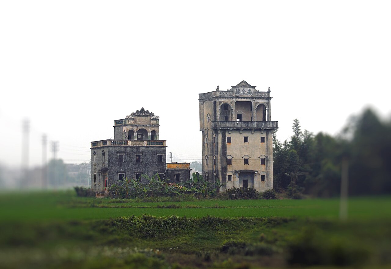
Kaiping Diaolou and Villages in Guangdong Province was inscribed as UNESCO World Heritage in 2007. The property comprises 1,833 surviving diaolou (fortified residential towers) distributed across four village clusters in Kaiping County: Zili, Jinjiangli, Sanmenli and Majianglong. Construction peaked between 1920 and 1940, financed by remittances from overseas Chinese emigrants in North America, Southeast Asia and Australia; the towers combine Chinese courtyard-house planning with European Baroque, Roman, Gothic and Art Deco decorative elements applied to external facades, producing an architectural type found nowhere else in China.
South China Karst and Cambrian fossils: Guilin, the Zuojiang rock art and western connections South China Karst/Guilin 400 km west, 4 hours HSR; Chengjiang Fossil Site 1,200 km northwest, 10h+ HSR via Kunming
The South China Karst UNESCO inscription (2007, extended 2014) is the most geologically significant UNESCO site in proximity to Kaiping, at approximately 400 kilometres west reachable by high-speed rail from Guangzhou South to Guilin North in approximately 2 hours, with Kaiping itself accessible from Guangzhou by bus or car in approximately 2 hours before the rail connection. The South China Karst is a serial inscription covering four karst sub-types across three provinces: the Stone Forest (Shilin) near Kunming in Yunnan (pinnacle karst), the Libo Karst in Guizhou (cone karst), the Wulong Karst in Chongqing (canyon and collapse karst), and the Guilin karst in Guangxi (tower karst on the Li River). The Guilin component is the most accessible and best known outside China; the Li River valley between Guilin and Yangshuo, approximately 83 kilometres in length, is the defining image of tower karst topography in Chinese visual culture. The river cruise from Guilin’s Zhujiang Pier to Yangshuo takes approximately 4 hours and passes the Nine-Horse Fresco Hill (Jiuma Hua Shan), the limestone formation whose reflection in the Li River appears on the reverse of the 20-yuan renminbi note. The 20-yuan note image, introduced with the fifth series of RMB in 1999, depicts the view from Xingping, approximately 50 kilometres downstream from Guilin, with the Nine-Horse Fresco Hill on the right bank; the mountain’s name derives from a traditional game of identifying horses in the water staining and vegetation patterns on the cliff face, with legend holding that a viewer who can find all nine horses will pass the imperial examinations. The tower karst of the Guilin area formed over approximately 270 million years through a process of differential dissolution: acidic groundwater (enriched with CO₂ from organic decay in the soil) dissolves the soluble limestone along fracture lines and bedding planes, leaving isolated resistant pillars as the surrounding rock is removed. The towers of the Li River valley rise 200 to 500 metres above the surrounding flat plain; their steep sides, narrow summit profiles and lack of talus at the base are characteristic of advanced tropical tower karst, distinguishing Guilin from the more rounded cone karst of Libo or the arch-and-bridge karst of Wulong.
The Zuojiang Huashan Rock Art Cultural Landscape in Guangxi, inscribed as UNESCO World Heritage in 2016, is approximately 300 kilometres south of Guilin, reachable in approximately 4 hours by bus or car from Guilin, or in a longer combined journey from Kaiping via Guangzhou and Nanning by high-speed rail (approximately 5 to 6 hours total travel). The Zuojiang inscription covers 38 clusters of rock paintings distributed along approximately 105 kilometres of the Zuojiang River valley and its tributary the Mingjiang River in the Chongzuo area of Guangxi. The paintings were made by the Luoyue people, an ancestral group of the modern Zhuang ethnic minority of Guangxi, using red ochre (hematite pigment mixed with animal fat and blood) applied to near-vertical cliff faces above the high-water line of the river at heights ranging from 5 to 100 metres. The largest single panel at Huashan (Flower Mountain) is 172 metres wide and 44 metres high and contains 1,900 individual figures; the dominant motif across all 38 clusters is a schematic human figure in frontal stance with arms raised and knees bent, identified in Zhuang ethnographic tradition as a posture of ritual dance performed for the river deity. Dating is approximately 500 BCE to 200 CE based on radiocarbon measurements from pigment residues and contextual stratigraphy; the Zuojiang paintings are therefore contemporary with the Han dynasty’s southward expansion into the region. The relationship between the Zuojiang rock art and the Kaiping Diaolou is thematic rather than geographical: both represent the cultural production of non-Han communities in the Pearl River Delta watershed negotiating identity under external pressure—the Luoyue under Han expansion, the Kaiping overseas Chinese communities under the economic and social disruption of early twentieth-century Guangdong. Combining the Zuojiang rock art with a South China Karst visit is most efficient via Nanning as a hub, with the Chongzuo sites approximately 170 kilometres south of Nanning and the Libo Karst approximately 300 kilometres north of Nanning.
The Chengjiang Fossil Site (Chengjiang Biota) in Yunnan Province, inscribed as UNESCO World Heritage in 2012, is approximately 1,200 kilometres northwest of Kaiping and accessible from Kaiping via a combination of bus/car to Guangzhou, high-speed rail from Guangzhou South to Kunming South (approximately 5 hours), and car from Kunming to Chengjiang County (approximately 70 kilometres, 1 hour). The Chengjiang site is a Cambrian Lagerstatte (exceptionally preserved fossil deposit) dated to approximately 520 million years ago; it contains soft-bodied organisms from the early Cambrian period that do not normally fossilize, preserved in fine siltstone under conditions that captured their anatomy in detail. More than 250 species have been described from Chengjiang, including representatives of most modern animal phyla as well as extinct body plans; the site provides the most complete known snapshot of the Cambrian biota in East Asia, complementing the Burgess Shale in Canada (Cambrian of the Rocky Mountains) and the Sirius Passet fauna of Greenland. The invertebrate fauna includes Fuxianhuia protensa (a stem-arthropod with preserved cardiovascular tissue), Myllokunmingia (an early vertebrate candidate with gill structures), and Anomalocaris (a Cambrian apex predator known from multiple sites globally), all preserved in the same depositional horizon. The museum at the Chengjiang World Heritage site, opened in 2021, displays original specimens and allows visitors to observe ongoing palaeontological fieldwork. The Chengjiang site is geographically close to the Shilin Stone Forest component of the South China Karst inscription (approximately 90 kilometres from Kunming), making a combined Yunnan itinerary of Chengjiang fossils and Shilin pinnacle karst practical within a two-day visit.
Southeast circuits: Kulangyu/Gulangyu Island and the Historic Centre of Macao Gulangyu/Xiamen 500 km northeast, 5h HSR from Guangzhou; Macao 300 km south, 3h bus+ferry
Kulangyu (Gulangyu Island) in Xiamen, Fujian Province, inscribed as UNESCO World Heritage in 2017, is approximately 500 kilometres northeast of Kaiping and reachable in approximately 5 hours by high-speed rail from Guangzhou South to Xiamen North, plus a short ferry crossing (approximately 6 minutes) from Xiamen’s Lunchang Ferry Terminal to Gulangyu. Gulangyu is an island of 1.87 square kilometres off the coast of Xiamen that was designated an International Settlement under the Treaty of Nanjing aftermath (from 1903) and the Municipal Council governance framework, with 13 countries maintaining concessions on the island. The UNESCO inscription recognises the island’s built environment as a concentration of buildings mixing Chinese traditional courtyard-house forms with European neoclassical, colonial and art nouveau architecture, produced by the same conditions that generated the Kaiping Diaolou: overseas Chinese emigrant remittances financing hybrid architectural commissions, and the presence of foreign architectural models introduced through colonial and treaty-port contact. The connection between Gulangyu and Kaiping is direct: both sites are products of the same demographic and economic phenomenon of the overseas Chinese (Huaqiao) communities of the late Qing and early Republican period, building in their home regions with remittance capital and in architectural styles learned or observed abroad. The Gulangyu buildings are urban—terraced town houses, consulate buildings, institutional headquarters—while the Kaiping Diaolou are rural and defensive; the same cultural mixture, different functional programme. Gulangyu also contains the highest concentration of pianos per capita of any island in China—a consequence of European music education at the island’s missionary schools in the early twentieth century that has become both a local identity marker and a tourist attraction; the island hosts the Piano Museum with over 100 historic instruments. The village of Zili in the Kaiping inscription, whose entire pre-1949 population emigrated—primarily to Australia, Canada and the United States—and whose towers and courtyard houses have been maintained by overseas remittances ever since without a permanent residential population, represents the most complete example of the emigrant patronage phenomenon; Gulangyu’s International Settlement buildings represent the urban treaty-port variant of the same phenomenon in a different coastal geography.
The Historic Centre of Macao, inscribed as UNESCO World Heritage in 2005, is approximately 300 kilometres south of Kaiping and reachable in approximately 3 hours by bus from Kaiping to Guangzhou Tianhe bus station and then by ferry from Guangzhou Nansha or Guangzhou Lianhuashan terminal to Macao Outer Harbour (approximately 1 hour ferry). The Macao inscription covers 25 historic buildings and 8 public squares within the historic urban core of the Macao Peninsula, including the ruins of St. Paul’s Church (the Ba Cai, a 1602 CE Jesuit church whose façade survived the 1835 fire), the Guia Fortress and lighthouse (completed 1865, the first modern lighthouse on the South China coast), A-Ma Temple (a 1488 CE goddess-of-the-sea shrine predating Portuguese arrival) and the Senate Square (Leal Senado), with its distinctive black-and-white wave-pattern cobblestoning imported from the Azores. The Macao inscription reflects the 1557–1999 Portuguese colonial period and its architectural consequences for the Chinese population of the peninsula; like the Kaiping Diaolou, it documents a community’s response to Western contact through hybrid built form, though in Macao’s case the foreign architectural tradition was dominant and the Chinese elements are embedded within it. The combination of Kaiping (rural Guangdong, overseas Chinese defensive-residential architecture), Gulangyu (urban Fujian, treaty-port Chinese-European hybridity) and Macao (urban Guangdong/Portuguese colonial co-existence) in a single itinerary provides the most comprehensive available picture of the material culture of Chinese contact with Western powers in the nineteenth and early twentieth centuries, across three distinct functional and geographic contexts.
Practical information
Kaiping County is approximately 140 kilometres southwest of Guangzhou, reachable by intercity bus from Guangzhou’s Fangcun bus station or Tianhe bus station in approximately 2 hours, or by car via the G15 expressway in approximately 1 hour 45 minutes. The four inscribed village clusters are not contiguous: Zili Village is 12 kilometres south of Kaiping city; Jinjiangli is 8 kilometres south of Kaiping; Sanmenli is 15 kilometres southwest; Majianglong is 20 kilometres west. Public transport connections between the village clusters are limited; hired transport (taxi or private car) is the most practical way to visit multiple clusters in a single day. A hired car for the full day from Kaiping costs approximately 400–600 CNY (USD 55–85) and allows visits to all four clusters plus the立园 (Liyuan) heritage garden, an overseas-Chinese-funded private garden built in the 1930s by an American-based emigrant. Admission to each village cluster is charged separately. The village of Zili, the most photographed cluster (it contains the Mingshi Lou tower built in 1925 by Fang Runzhi, a Canadian-Chinese resident), has the most developed visitor facilities and is the practical starting point. Summer (May to September) is hot and humid; the rice-field landscape surrounding the towers is most photogenic in June and July when the paddies are green, and in October when the paddy is harvested golden. Guangzhou is the natural gateway city: flights connect to most major Chinese cities and international destinations, and the intercity bus network to Kaiping is frequent and reliable.
Frequently Asked Questions
Why did Kaiping emigrants build defensive towers rather than conventional Chinese courtyard houses when they returned from North America?
The building of defensive towers by returning Kaiping emigrants between the 1880s and the 1940s responded to specific conditions of rural insecurity in the Pearl River Delta during the late Qing and early Republican periods. The Siyi (Four Counties) region of Guangdong, which includes Kaiping, had high rates of emigration from the 1850s onward, initially to California gold mines and railway construction projects and later to Canada, Australia and Southeast Asia. The returning emigrants brought cash remittances in an economy where agricultural incomes remained extremely low; they became targets for bandit raids and kidnappings, which were endemic in the Guangdong countryside between 1900 and 1935 in the absence of effective state policing during the Republican period’s warlord era. The tower form—typically four to nine storeys of reinforced concrete with small windows and gun ports in the upper floors, a flat roof with corner bastions or a crenellated parapet, and heavy iron shutters—was a direct response to the kidnapping and raid threat. The architectural vocabulary of the facades (Baroque cornices, Ionic columns, arched loggias, Venetian Renaissance balustrades, Art Deco angular relief panels applied to the exterior walls above the second floor) was drawn from pattern books, postcards and buildings seen by emigrants in their destination countries; the decorative vocabulary had no defensive function but expressed the owner’s cosmopolitan experience and economic achievement. The result is architecturally distinctive: the structural and functional logic is Chinese military architecture (the Hakka tulou round houses of Fujian are a comparable defensive-residential form from a different region), while the surface decoration is a compressed catalogue of European ornamental styles from the 1880s through the 1930s, applied without the European buildings’ load-bearing justification. The 1,833 surviving towers represent the residue of a larger original stock; some towers were demolished after 1949, and others have been lost to flood damage, neglect or conversion.
What architectural styles are mixed in the Kaiping Diaolou and how did the emigrants access European architectural vocabulary?
The architectural vocabulary of the Kaiping Diaolou exterior facades draws on at least six distinct European and American styles, rarely applied consistently within a single tower and frequently combining elements from multiple traditions on the same facade. The most common elements are Roman and Romanesque arched openings at the entrance and window level (semicircular arches, rusticated keystones, engaged pilasters); Gothic pointed arches and traceried balustrade panels in the intermediate storeys; Italian Renaissance and Baroque cornices, pediments and string-courses separating floor levels; Art Deco geometric relief panels and angular mouldings on buildings constructed after approximately 1925; and neoclassical column orders (Ionic and Corinthian) applied as engaged columns or pilasters to load-bearing concrete corners. The source of this vocabulary for the builders was multiple. Emigrants returning from San Francisco, Vancouver, Melbourne and Singapore had encountered European and American commercial and residential architecture in those cities; they communicated preferences to local builders through letters, photographs and postcards. Local master builders (Chinese craftsmen who had not themselves emigrated) adapted the vocabulary from available published pattern books, commercial catalogues and the illustrated magazines that circulated in the Pearl River Delta by the 1910s. The resulting buildings are hybrids in the specific sense that no European architect was involved in their design: the spatial organisation, structural logic, material specification (local brick, then reinforced concrete after 1910) and functional programme (residential, defensive, storage) are Chinese, while the surface ornamental vocabulary is European or American, filtered through memory, illustration and local craft interpretation. Architectural historians have described the Kaiping Diaolou as an example of vernacular cosmopolitanism: a locally produced architecture that absorbs external stylistic information into a pre-existing building type without transforming the underlying type.
What happened to the village of Zili after its population emigrated, and how has the property been maintained without permanent residents?
Zili Village (Zili Cun) is the most extreme example within the Kaiping inscription of emigrant-driven depopulation: by the 1930s, virtually the entire adult male population of the village had emigrated, primarily to Australia but also to Canada and the United States, leaving behind women, children and elderly residents in the towers and courtyard houses. After the establishment of the People’s Republic in 1949 and particularly after remittance flows from capitalist countries were officially discouraged in the 1950s, the village’s economic connection to its diaspora was severed; the remaining resident population declined over subsequent decades as younger generations moved to Kaiping city and Guangzhou. By the time of the UNESCO inscription nomination in the early 2000s, Zili had effectively no permanent resident population; the 15 diaolou and 8 residential buildings were empty or maintained by single elderly caretakers. The maintenance of the buildings had been sustained sporadically through the post-1978 reform period by remittances from the overseas descendants of the original emigrants, many of them second- and third-generation Australians and Canadians with no direct experience of Zili but with family identity attached to the property. The UNESCO inscription formalised a conservation framework: the Kaiping County government entered into management agreements with the overseas ownership families, establishing a caretaker system for each building and a maintenance fund fed by a portion of the site admission revenue. The current management situation places Zili in a legally and practically unusual category: a UNESCO World Heritage village property with no permanent resident community, maintained as heritage by overseas diaspora ownership and state conservation management simultaneously. The 2007 inscription has brought significant visitor infrastructure investment—a new access road, a visitor centre, signage, caretaker accommodation—but the fundamental condition of an inhabited-but-not-lived-in village has not changed.
Sources
- S1 — UNESCO World Heritage Centre — Kaiping Diaolou and Villages (Ref. 1112) — https://web.archive.org/web/20230601000000/https://whc.unesco.org/en/list/1112/
- S2 — Kaiping City Cultural Heritage Bureau — https://whc.unesco.org/en/list/1112/
- S3 — Kuhn, Dieter. <em>The Age of Confucian Rule: The Song Transformation of China</em>. Harvard University Press, 2009. ISBN: 978-0-674-03661-1.
Spotted an error? Write to editorial@culturalheritageonline.com and we correct it the same day.
.jpg)