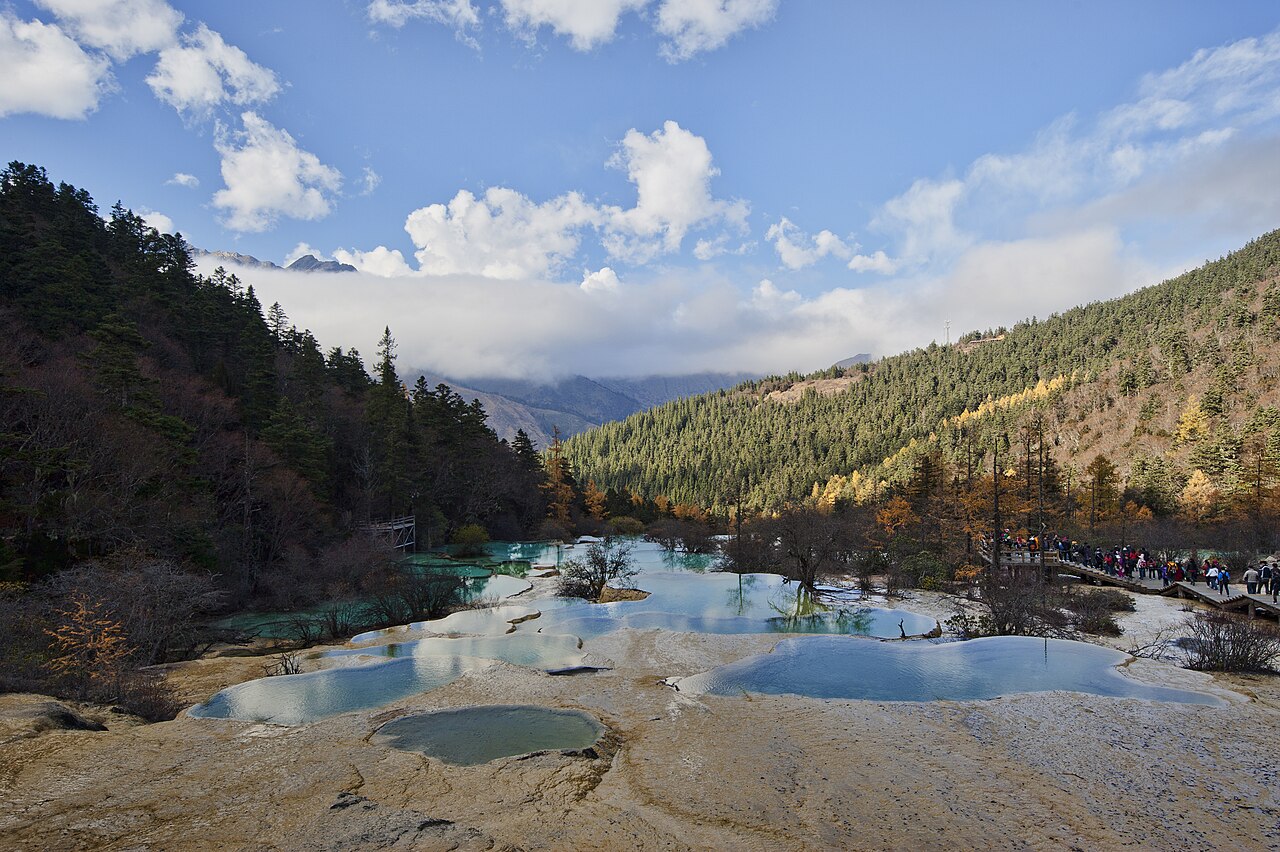
Huanglong Scenic and Historic Interest Area was inscribed as a UNESCO World Heritage Site in 1992, covering 700 square kilometres of the Minshan mountain range in Songpan County, northwestern Sichuan Province. The site contains approximately 3,400 travertine pools arranged in terraced sequences along a 3.6-kilometre calcite ridge at elevations between 3,400 and 5,100 metres, fed by calcium-carbonate-rich spring water that has been precipitating calcium carbonate deposits for an estimated 10,000 years; the pools’ characteristic turquoise and blue colouration results from light scattering in water with dissolved calcium carbonate concentrations of 200–300 mg per litre. The site is accessible from Chengdu in approximately 8 hours by road (480 kilometres via Mao County and Chuanzhusi), or 1 hour by flight to Jiuzhaigou/Huanglong Airport (JZH) followed by a 40-kilometre bus transfer to the Huanglong valley entrance.
Jiuzhaigou and the Tibetan Plateau fringe: a valley of coloured lakes and steppe wetlands 100–600 km, 2–8 hours by road
Jiuzhaigou Valley Scenic and Historic Interest Area (UNESCO 1992) is located approximately 100 kilometres south of Huanglong by road through Zharu Valley and along the banks of the Bai River, a journey of approximately 2 hours by tourist bus. Both Huanglong and Jiuzhaigou were inscribed simultaneously in 1992 and are frequently treated as a single visit in the standard tourist circuit using Jiuzhaigou/Huanglong Airport (JZH) as the hub; the airport was built partly to provide access to both sites in a single trip and is served by direct flights from Chengdu (50 minutes), Beijing (2.5 hours) and Shanghai (3.5 hours). Jiuzhaigou covers 720 square kilometres of the Minshan range between 1,996 and 4,764 metres elevation (Ganzigonggai Peak) and contains 118 lakes, 17 waterfalls and 5 tufa shoals along three tributary valleys of the Jiuzhaigou River; the characteristic lake colours (ranging from pale green to deep cobalt, from translucent turquoise to milky white) result from the same calcium-carbonate precipitation chemistry that colours the Huanglong pools, with variations determined by pool depth, the density of submerged travertine formations and the angle of incident sunlight at different times of day. The Five-Flower Lake (Wuhua Hai), one of the most photographed of Jiuzhaigou’s lakes, is a shallow pool of approximately 5 metres maximum depth at 2,472 metres elevation whose submerged travertine ridges, algal mats in multiple colours and sunken logs are visible through water of exceptional clarity; the lake has no outflow and receives water only from a spring at its head, which may account for the low turbidity. The 2017 Jiuzhaigou earthquake (magnitude 7.0, 8 August 2017) significantly damaged the valley floor infrastructure, causing landslides that altered several lakes and waterfalls; restoration and visitor route reconstruction continued through 2019 and the site reopened in September 2019 with a reduced daily visitor cap of 5,000 persons (down from the pre-earthquake cap of 12,000). Qinghai Hoh Xil (UNESCO 2017) is located approximately 600 kilometres northwest of Huanglong as the crow flies, on the Tibetan Plateau at an average elevation of 4,600 metres, covering 3,735,132 hectares of uninhabited alpine steppe, lake basins and permafrost terrain. The site is one of the largest terrestrial wildlife reserves in Asia and protects a population of approximately 70,000 chiru (Tibetan antelope), whose annual migration route to calving grounds at Zonag Lake is the primary ecological event of the inscription; the migration begins in May, when pregnant females walk north from their winter grazing territory in a herd of several thousand animals, covering approximately 300 kilometres in 3–4 weeks. Road access from Huanglong to Hoh Xil is not practical for standard visitors; the Qinghai–Tibet Highway (National Route G109) and the Qinghai–Tibet Railway (Golmud–Lhasa line, opened 2006) both cross the reserve’s eastern boundary, and the nearest accessible observation point for chiru migration is at Wudaoliang on the highway, approximately 1,100 kilometres from Chengdu by road via Xining. Hoh Xil is best treated as an extension for visitors arriving from or departing to Qinghai Province rather than as a day trip from Huanglong, but its ecological relationship to the Tibetan Plateau ecosystem that Huanglong’s high-altitude travertine system also represents makes it the appropriate regional comparison: both sites document the consequences of high-altitude calcium-rich geology and cold-season climate on biological and geomorphological processes, though at very different spatial scales.
Chengdu basin: irrigation engineering and a panda sanctuary 200–350 km south, 1.5–8 hours by road
Mount Qingcheng and the Dujiangyan Irrigation System (UNESCO 2000) is located approximately 300 kilometres south of Huanglong by road via the G213 highway through Mao County and Dujiangyan city, a journey of approximately 5–6 hours. From Chengdu, Dujiangyan is reachable in approximately 1 hour by metro and Chengdu rail to Dujiangyan station, with Mount Qingcheng a further 15 kilometres by bus. The UNESCO inscription covers two adjacent but thematically distinct elements: the Dujiangyan dam system, designed by the Qin-dynasty engineer Li Bing around 256 BCE as a flow-diversion and silt-exclusion structure on the Min River, and Mount Qingcheng (1,260 metres), the Taoist sacred mountain 15 kilometres southwest. The Dujiangyan system’s central innovation is the Fish Mouth Levee (Yuzui), a teardrop-shaped island in the river channel that divides flow between an inner channel (supplying the Chengdu Plain irrigation network) and an outer channel (carrying silt-laden floodwater away from the agricultural plain); the division is calibrated by the geometry of the levee so that approximately 40% of flow enters the inner channel in dry season and 60% enters the outer channel in flood season, without sluice gates, electricity or mechanical intervention. The Chengdu Plain now under irrigation covers approximately 1.5 million hectares, supports an agricultural population of approximately 7 million and has functioned continuously for 2,270 years—the longest-functioning irrigation system in the world still in active use according to the UNESCO inscription criteria. The Sichuan Giant Panda Sanctuaries (UNESCO 2006) cover 924,500 hectares across the Qionglai and Jiajin Mountain ranges, with Wolong Nature Reserve (Wolong National Nature Reserve, 200,000 hectares) as the largest and best-known component. Wolong is approximately 140 kilometres south of Huanglong by road via the Yentang River valley and Gengda, a journey of approximately 3–4 hours; alternatively, from Chengdu, Wolong is approximately 130 kilometres west by road (2 hours). The China Giant Panda Conservation and Research Centre at Hetaoping in Wolong was destroyed in the 2008 Sichuan earthquake (magnitude 7.9, 12 May 2008) and subsequently rebuilt at Shenshuping, a site 2 kilometres further up the valley and outside the landslide zone; the new centre opened 2013 and currently houses approximately 50 giant pandas in a semi-wild reserve area of 500 hectares. The Wolong giant panda population in the wild is surveyed every 10 years: the 2021 national census counted 1,864 wild giant pandas across Sichuan, Shaanxi and Gansu provinces, up from 1,596 in the 2003 census, a recovery attributed to the expansion of nature reserves from 13 in 1998 to 67 by 2021. The Jiuzhaigou/Huanglong Airport hub makes a logical base for both sites: fly in to JZH, visit Huanglong and Jiuzhaigou (2–3 days), drive south to Chengdu via Mao County (8 hours) with a stop at Wolong en route (90 kilometres west of Chengdu), then use Chengdu as a base for Dujiangyan and Qingcheng the following day.
Practical information
Huanglong’s single valley trail ascends from the entrance gate at 3,145 metres to the Guse Temple (Huanglong Temple) at the head of the calcite ridge at 3,576 metres, a climb of 431 metres over 7.5 kilometres. The standard circuit (ascent by trail, descent by cable car) takes approximately 4 hours; the cable car upper station at 3,508 metres reduces the walk to approximately 2.5 hours for visitors with altitude or mobility concerns. The elevation is significant: Huanglong sits above 3,400 metres throughout, and altitude sickness (headache, nausea, fatigue) affects a proportion of lowland visitors in the first 12–24 hours at this elevation. Acclimatisation at Songpan or Jiuzhu for one night before visiting Huanglong is recommended; Songpan town (35 kilometres north, 2,850 metres elevation) has hotel accommodation in a more comfortable altitude range and is the standard overnight base for Huanglong visitors driving from Chengdu. The main annual Tibetan and Qiang festival at Huanglong (Huanglongsini Festival) takes place on the 15th day of the 6th lunar month, typically in July or early August; the celebration draws Tibetan and Qiang communities from the surrounding Songpan and Jiuzhaigou counties and includes ritual processions to the Huanglong Temple at the ridge head. Visitor numbers on festival day exceed normal daily caps; book accommodation at Songpan at least 2 weeks in advance for this period. The site is closed from November to late March due to ice formation on the travertine pools and access road.
Frequently Asked Questions
How are Huanglong’s travertine pools formed and why are they that colour?
Huanglong’s calcite ridge and its 3,400 pools are formed by a process called travertine or tufa precipitation: groundwater percolates through limestone bedrock in the Minshan mountains, dissolving calcium carbonate (CaCO₂) from the rock to form a solution of calcium bicarbonate (Ca(HCO₃)₂). When this calcium-rich water reaches the surface at Huanglong’s springs, a combination of lower atmospheric pressure (due to the high altitude), warming by sunlight and turbulence as the water flows downslope causes the dissolved carbon dioxide (CO₂) to escape from solution; as CO₂ leaves the water, the calcium carbonate that was held in solution by the carbonic acid reverts to solid form and precipitates out of the water onto the stream bed. Over millennia, these accumulating calcium carbonate deposits build up rims and walls across the slope, impounding water in the pools above them and growing slowly upward as new precipitation adds to the existing rim; the oldest portions of the Huanglong calcite ridge are estimated to have begun accumulating approximately 10,000 years ago based on uranium-thorium dating of core samples. The colour of the pools—ranging from pale cream at the shallowest pool edges to deep turquoise and blue in the deeper basins—is primarily a product of light scattering (Rayleigh scattering) in the suspended calcium carbonate particles and the dissolved mineral load: the blue-green wavelengths of sunlight penetrate the water column and are scattered back to the viewer while red wavelengths are absorbed, and the intensity of the blue-green colour increases with dissolved mineral concentration and with pool depth. The pale cream of the pool rims and the white of dry or inactive areas reflects the calcium carbonate deposit itself when it is no longer covered by water.
What happened to the Wolong Panda Centre in the 2008 Sichuan earthquake and how was it rebuilt?
The 2008 Sichuan earthquake (magnitude 7.9, epicentre at Wenchuan, 12 May 2008) was one of the deadliest natural disasters in Chinese history, killing approximately 69,000 people and injuring 374,000; Wenchuan County, which includes the Wolong Nature Reserve, was in the maximum intensity zone. The China Giant Panda Conservation and Research Centre at Hetaoping in Wolong was severely damaged by the initial earthquake and subsequent landslides: buildings collapsed or were rendered structurally unsound, enclosure fences were broken, access roads were blocked by debris, and 9 of the approximately 60 giant pandas resident at the centre died—6 from trauma and 3 from subsequent stress-related illness or escape into the wild. The surviving pandas were evacuated to the Chengdu Research Base of Giant Panda Breeding (22 pandas) and to the Ya’an Bifengxia breeding centre (29 pandas) via emergency road convoys in the weeks following the earthquake, a logistical operation complicated by the destruction of the main road to Wolong (G350) which required temporary rerouting via a 4-hour detour through Luding County. The new centre at Shenshuping, 2 kilometres upslope from Hetaoping and outside the landslide hazard zone identified in the post-earthquake survey, was built between 2009 and 2013 with funding from the Wolong Nature Reserve administration and international conservation organisations including WWF; it is designed with a semi-wild reserve area of approximately 500 hectares where pandas practise foraging, climbing and other behaviours relevant to eventual wild release, rather than the fully managed enclosure model of the original Hetaoping centre. The earthquake created the opportunity—at enormous cost—to redesign the facility according to 21st-century conservation science rather than 1980s zoo management standards.
What does the Dujiangyan system tell us about pre-industrial hydraulic engineering compared to other UNESCO irrigation sites?
Dujiangyan (256 BCE) belongs to a global category of UNESCO-inscribed hydraulic infrastructure that includes the Aflaj irrigation systems of Oman (2006, canals dated to 500 CE), the ancient karez qanat systems of Iran (2016, tunnels dated to 800 BCE–0 CE) and the Ahwar of southern Iraq (2016, marsh irrigation systems with Bronze Age origins). What distinguishes Dujiangyan from all of these is the combination of scale, longevity and the absence of storage: where most pre-industrial irrigation systems rely on a dam to store water in a reservoir and then release it through sluice gates, Dujiangyan is a run-of-river diversion system with no dam and no gate—the Fish Mouth Levee (Yuzui) divides the Min River channel into inner and outer branches by geometry rather than by a controllable barrier, and the Bottle-Neck Channel (Baopingkou) regulates inner-channel intake by the fixed geometry of the channel width cut through the spur of Yulei Hill. Li Bing’s insight—that the natural hydraulics of a divided channel in a curved river reach would produce the correct flow split between dry season and flood season without human intervention, provided the geometry was correct—is verified by 2,270 years of continuous operation without structural failure. The engineering is maintained by periodic dredging of the inner channel (carried out in the traditional Qingming festival period each April, when the Min River is at its annual minimum flow) and by inspection of the levee geometry; these maintenance procedures are documented in an inscription stele at the site and have been transmitted continuously in the local irrigation management tradition. By comparison, the Marib Dam in Yemen (built approximately 750 BCE, inscribed in the Lands of Frankincense UNESCO site), which also irrigated a large agricultural plain, failed catastrophically in 575 CE when the dam structure was breached; the failure is commemorated in the Quran (Surah Saba) as a divine punishment. Dujiangyan’s engineering avoids the single-point-of-failure weakness of dam-based systems precisely by distributing the hydraulic function across geometry rather than concentrating it in a gate.
Sources
- S1 — UNESCO World Heritage Centre — Huanglong Scenic and Historic Interest Area (Ref. 638) — https://web.archive.org/web/20230601000000/https://whc.unesco.org/en/list/638/
- S2 — Huanglong National Scenic Area Administration — https://whc.unesco.org/en/list/638/
- S3 — Seidensticker, John. <em>Riding the Tiger: Tiger Conservation in Human-Dominated Landscapes</em>. Cambridge University Press, 1999. ISBN: 978-0-521-64835-6.
Spotted an error? Write to editorial@culturalheritageonline.com and we correct it the same day.