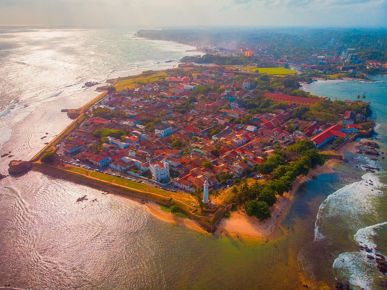
Galle Fort is the most complete example of a European colonial maritime fortification in South or Southeast Asia — a 90-hectare walled town built in coral and granite that still functions as a living neighborhood, its 17th-century Dutch street grid intact and occupied, its ramparts walkable at sunset by the same route the Dutch garrison used to inspect the walls. The Portuguese built the first stockade here in 1588; the Dutch VOC rebuilt it into its current form by the 1680s; the British modified it after 1796; and the 2004 Indian Ocean tsunami, which killed more than 30,000 people in the surrounding Southern Province, passed largely over the fort’s walls and left the historic core intact. UNESCO inscribed the Old Town of Galle and its Fortifications in 1988.
The Portuguese Stockade and the Dutch Rebuilding Southern Province, Sri Lanka · 120 km south of Colombo
The Portuguese arrived on the southwestern coast of Ceylon in 1505 CE and established their first significant settlement at Colombo, not Galle. Galle came into use as a harbor — sheltered by a rocky promontory that projected into the Indian Ocean — and by 1588 CE the Portuguese had constructed a small fort on the promontory tip, primarily to protect their spice trade route and keep Arab and Muslim merchant vessels out of what they considered their commercial sphere. The structure was modest: earthworks and timber, possibly some coral-stone walls, with a few cannon positions guarding the harbor entrance. It served its purpose as a frontier military post rather than a planned colonial city.
The Dutch VOC (Vereenigde Oostindische Compagnie — the Dutch East India Company) took Galle from the Portuguese in 1640 CE after a combined assault with Kandyan kingdom forces who were happy to see their previous colonial overlords replaced. The Dutch found the Portuguese fortification inadequate for their purposes and immediately began planning a new structure on a grander scale. By the 1680s, the rebuilding was substantially complete: a 14-bastion fortification with 2.5 kilometers of walls enclosing 90 hectares, built with coral stone quarried from the harbor floor and granite brought from the interior. The bastions — named with Dutch piety for stars (Star Bastion), the sun (Sun Bastion), and cardinal virtues — were positioned to provide overlapping fields of fire with no blind angles along the full perimeter. The garrison could theoretically defend every meter of wall simultaneously, which was the architectural ideal of late 17th-century European military engineering.
Inside the walls, the Dutch built a town on a rational grid — straight streets at right angles, drainage channels running beneath the paving, separate quarters for different communities. The VOC needed not just soldiers but merchants, administrators, translators, and craftsmen; the fort town was planned to house a functioning colonial society rather than simply a military installation. This is why Galle Fort today contains not just bastions and cannon positions but a church, a hospital, a warehouse, a law court, a lighthouse, and a consistent urban texture of two-storey Dutch merchant houses with deep verandahs and interior courtyards. The building proportions and street widths were set by VOC urban planning standards applied across Dutch colonial settlements in Batavia, Colombo, Cape Town, and Galle — which is why a Dutch colonial building in Galle looks structurally similar to one in Indonesia.
The Groote Kerk, the 2004 Tsunami, and Life Inside the Walls Galle Fort interior · entirely walkable; main gate 3 min from Galle train station
The Groote Kerk — the Dutch Reformed Church — was completed in 1755 CE and remains the oldest Protestant church still standing in Sri Lanka. It replaced an earlier Dutch church on the same site and was built to serve the fort’s Dutch Reformed congregation, which by the mid-18th century included Dutch settlers, their mixed-descent descendants, and converted Sri Lankans. The exterior is plain to the point of austerity — whitewashed walls, a simple gable, no ornamental program — in the characteristic Calvinist tradition that considered religious decoration a distraction from worship. The interior is more affecting: the original flooring consists of Dutch tombstones, laid flat as pavement, with epitaphs in Dutch and Latin that track the lives and deaths of VOC employees and their families across more than a century of occupation. Names, ranks, dates, heraldic devices — the floor is simultaneously a liturgical space and an archive of colonial demography. The church is still used for services and is open to visitors outside service times.
The Dutch VOC warehouse, now the National Maritime Museum, preserves the fort’s other significant institutional legacy. The warehouse was built for storing spices, textiles, and trade goods moving through Galle’s harbor — the port handled a substantial share of the VOC’s Ceylon trade in pepper, cinnamon, and elephants — and its massive coral-stone walls and timber roof trusses reflect the engineering requirements of storing valuable goods in a tropical maritime climate. The museum holds excavated ceramics, navigation instruments, cannon, and a reconstruction of a VOC trading vessel’s cargo hold.
The fort’s survival of the December 2004 Indian Ocean tsunami was not accidental, though it was not exactly planned either. The tsunami struck the southern coast of Sri Lanka with wave heights reaching 9–11 meters in some locations; in Galle’s Southern Province, more than 30,000 people died and entire coastal settlements were erased. The fort town — protected on three sides by the 17th-century coral-stone ramparts — absorbed much of the wave energy on those flanks; the harbor side, where the walls were lower, saw significant flooding, but the fort’s interior suffered far less damage than the unprotected coastal areas immediately outside the walls. The event brought an unexpected attention to the fort’s structural heritage: post-tsunami reconstruction funding supported conservation work, and the fort’s visibility as a place of relative safety reinforced local awareness of its value.
Approximately 4,000 people live inside the fort today. The community is not a heritage showpiece — families have lived here continuously for generations, businesses operate alongside restored colonial guesthouses, and the Dutch grid of streets accommodates both a functioning neighborhood and a significant tourist economy. The evening walk on the sea ramparts, from the Clock Tower bastion around to the Star Bastion, with the Indian Ocean on one side and the fort’s rooftops on the other, is one of the most reliably satisfying urban experiences in South Asia.
Practical information
Galle is 120 km south of Colombo on the Southern Expressway, about 1 hour 45 minutes by car or taxi from the capital. The intercity train from Colombo Fort station takes approximately two hours and follows the coastal line with ocean views — the train is comfortable, scenic, and highly recommended over road travel for the experience alone. The main gate of the fort is a three-minute walk from Galle train station. Tuk-tuks are available at the station and in the fort for visitors with mobility constraints, but the fort is compact and best explored on foot.
The fort is open and unticket-gated; entry is free, though the Groote Kerk and National Maritime Museum charge small admission fees. The best months to visit are December to March: the southwest monsoon (May to October) brings heavy rain and strong swells that make the rampart walk uncomfortable and occasionally dangerous. Early morning is the best time to walk the main street, Church Street, before the day-trippers arrive from Colombo. Accommodation inside the fort ranges from guesthouses in restored Dutch houses to boutique hotels; book well in advance during the December to February high season. Sunscreen, a water bottle, and sturdy shoes are sufficient preparation for a full day’s exploration; the ramparts are uneven in places and have no shade.
Frequently Asked Questions
How did the Dutch VOC come to control Galle, and what did they export from the port?
The Dutch East India Company arrived in Ceylon in the early 17th century with the explicit goal of breaking the Portuguese monopoly on the island’s cinnamon trade. Ceylon cinnamon — Cinnamomum verum — was the highest-value spice in the European market of the period, significantly more aromatic and delicate than the cassia bark sold as “cinnamon” from other sources, and the Portuguese had controlled the trade since the early 16th century. The Dutch allied with the Kandyan kingdom, which resented Portuguese control of the coastal lowlands, and the alliance provided both the ground forces and the political legitimacy for the Dutch to capture the Portuguese coastal forts one by one: Galle in 1640 CE, Colombo in 1656 CE, Jaffna in 1658 CE. The VOC then signed a treaty with the Kandyan king that gave the Company the monopoly on cinnamon export in exchange for military support. Galle’s harbor became the primary export point for cinnamon bark harvested by Sinhalese peelers (Salagama caste families, who held a hereditary monopoly on the work) and for other goods including elephants, which the VOC sold to the Mughal court and other South Asian rulers. Pepper from Java, textiles from Coromandel, and porcelain from China also passed through Galle as part of the VOC’s inter-Asian trade network. The Company’s accounts show Galle as consistently profitable through the 17th century; by the 18th century, as the spice trade became commoditized, profitability declined, and the Dutch ceded the fort to Britain in 1796 without significant military contest.
Is it true that Galle Fort survived the 2004 tsunami because of the Dutch walls?
The short answer is: partially, and the picture is more complex than the popular narrative suggests. The 2004 Indian Ocean tsunami, triggered by a magnitude 9.1 earthquake off the coast of Sumatra, struck Sri Lanka’s southern and eastern coasts on the morning of December 26, 2004. In Galle’s Southern Province, the death toll exceeded 30,000 people; the town of Galle itself, outside the fort, was significantly damaged. Within the fort, damage was comparatively limited, and this disparity was widely reported as evidence that the 17th-century Dutch ramparts had protected the enclosed community. The mechanism is real on three sides: the coral-stone walls, between 1.5 and 2 meters thick at the base, absorbed wave energy and reduced the wave height and velocity that reached the fort interior. The harbor-facing north side of the fort, where the wall is lower and the geometry less favorable, experienced flooding that damaged buildings on the streets closest to the water. So the protection was real but partial and directionally dependent. What the walls provided was not impermeability but a significant reduction in wave force — enough to prevent the structural collapse and lethal inundation that destroyed unprotected coastal buildings. The event is studied by disaster risk researchers as a case of historical infrastructure providing unplanned but effective natural hazard mitigation.
What is the best way to experience the fort beyond the standard tourist route?
Most visitors arrive, walk Church Street and the main bazaar, reach the lighthouse, walk the southern rampart to the Star Bastion, and leave — a circuit that takes about two hours and misses the quieter parts of the fort. The more rewarding approach is to start at the main gate early morning, when the streets are relatively empty, and explore the residential grid away from Church Street: Hospital Street, Middle Street, and Leyn Baan Street have Dutch-era houses in varying states of preservation, occupied by families who have lived here for generations alongside small shops and workshops. The National Maritime Museum on Church Street deserves an hour if maritime history and VOC material culture interest you. The Groote Kerk is best visited mid-morning when light comes through the side windows and falls across the tombstone floor. The rampart walk is best at late afternoon on the southwestern side, facing the sun over the ocean, then continuing around to the Star Bastion in the cooling evening. The fort has a functioning Muslim quarter near the Meeran Jumma Mosque — one of several mosques inside the walls reflecting the fort’s pre-Dutch Arab trading history and the continued Muslim commercial presence through the Dutch and British periods — which is worth locating if you want to understand the fort’s full communal history rather than its Dutch architectural highlight reel.