
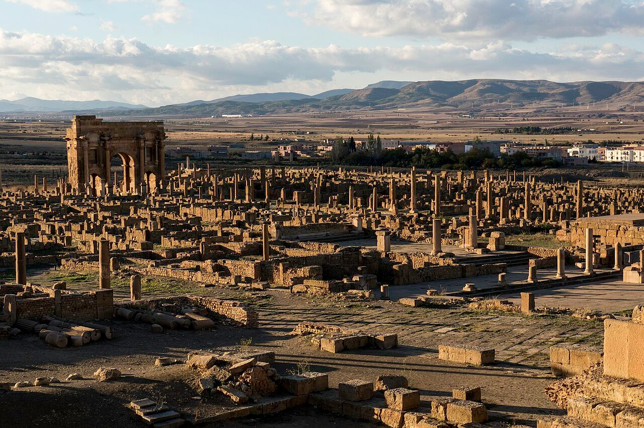
Timgad — Colonia Marciana Traiana Thamugadi — was founded by Emperor Trajan in 100 CE as a planned military colony for veterans of the Third Augustan Legion, on a flat plateau of the Aurès Mountains at 1,050 metres altitude. The UNESCO World Heritage inscription of 1982 recognises one of the finest surviving examples of Roman urban planning anywhere in the ancient world: an orthogonal grid so precise that it reads as a geometric exercise from the air, yet was home to a living city of over 30,000 people.
The orthogonal grid and the monuments of a Roman colony Batna Province, northeastern Algeria, on the Algerian steppe
The aerial photograph that most clearly makes the case for Timgad is the one taken from altitude: the cardo maximus and decumanus maximus cross at right angles at the centre of the original walled colony, and from them a grid of secondary streets divides the space into equal rectangular insulae, the city blocks that Roman planners used as the basic unit of urban land allocation. The geometry is not approximate. It is the product of military surveying — the groma, the measuring rod, the precisely calculated land grants that rewarded legionary veterans with a standardised plot within a standardised city. Timgad was planned to house 15,000 veterans. It quickly outgrew that estimate: within a century, civilian settlement outside the original walls expanded the population to over 30,000.
The monuments that survive within this grid are extraordinary in their variety and their state of preservation. The Triumphal Arch of Trajan — also called the Arch of Trajan, constructed around 100 CE, 12 metres high — stands at the western end of the decumanus. Originally a three-bay structure, only the central arch remains, but it is intact to its cornice and retains carved decorative details. The Forum, lined with the principal civic buildings of the colony, occupies the central insula at the intersection of the two main streets: a colonnaded square surrounded by a basilica (law court and commercial exchange), a curia (council house), and a number of temples, including one dedicated to the Capitoline triad of Jupiter, Juno, and Minerva.
The Theatre at Timgad has a capacity of approximately 3,500 and is among the most intact Roman theatre structures in North Africa. The semi-circular cavea — the seating bank cut into the hillside south of the Forum — retains several rows of original stone seating. The scaenae frons (stage backdrop) has lost its upper storeys but the stage platform and the orchestral pit remain. During summer months the theatre hosts performances again, filling a space that has been in use for nearly two thousand years.
The figure that most consistently surprises visitors is the bath count: Timgad had 14 bath complexes, an extraordinarily high number for a city of its size — approximately one bath for every 1,000 inhabitants. Roman bath culture was not luxury; it was civic infrastructure as basic as the Forum. The bathhouses at Timgad vary enormously in scale, from large imperial complexes with mosaicked floors and hypocaust heating systems to small neighbourhood establishments serving a single insula. The Baths of the North and the Great Baths of the South are the most intact. The city also possessed a public library — the Bibliotheca Timgad — one of the largest libraries in Roman Africa, identified by a semicircular reading room whose walls carried niches for scroll cases.
The Christian city and the abandonment that preserved it Covered by Saharan sand from the 7th century until French excavations from 1881
The city Trajan founded was pagan, and its public monuments reflect the polytheistic religious landscape of the Roman Empire. By the 4th century CE, Timgad had become a substantial Christian city. A large cathedral basilica and several smaller churches were built within and outside the original colony walls, and Timgad acquired a bishop. More significantly, it became a centre of the Donatist schism — the dispute, centred in Roman North Africa, between Christians who held that the validity of sacraments depended on the moral status of the priest performing them (the Donatist position) and those who held that the sacraments were valid regardless (the Catholic position upheld by Augustine of Hippo). Timgad was a Donatist stronghold, and the physical record of this includes multiple basilicas attributable to the Donatist community.
The Vandals arrived in North Africa in 429 CE and established their kingdom at Carthage. Timgad’s position deep in the Aurès plateau kept it relatively marginal to the main Vandal coastal urban centres, though the city declined through the 5th century. The Byzantine reconquest of North Africa in 533 CE under Belisarius briefly returned Roman imperial authority to the region, but the Arab-Berber expansion of the late 7th century effectively ended urban life at Timgad. The city was raided, partly burned, and abandoned. Saharan sand and Aurès plateau soil then covered the ruins steadily for more than a millennium.
French military presence in Algeria, which began in 1830, eventually brought archaeologists to the steppe. Excavations at Timgad began in 1881 under French direction and continued for decades, progressively uncovering a city that had been substantially protected by its burial. The sand that ended urban life at Timgad also preserved pavement surfaces, lower wall courses, mosaic floors, inscriptions, and architectural fragments that would not have survived in a continuously inhabited city. The sobriquet “the African Pompeii” attaches to this quality: like Pompeii, Timgad is a city frozen by the event of its ending and preserved by what covered it — not volcanic ash but desert accumulation.
Practical information
Timgad is located in Batna Province in northeastern Algeria, approximately 35 km east of the provincial capital of Batna. The site is accessible by road from Batna, which is connected to Algiers by the A1 autoroute (approximately 400 km, four to five hours’ drive) and by rail. Batna has an airport (Mostefa Ben Boulaid Airport) with domestic services from Algiers and other Algerian cities. From Batna, Timgad is reached in under an hour by taxi or rental car via the RN88 road.
The site opens daily from early morning; hours vary seasonally. An on-site museum displays mosaics, sculptures, inscriptions, and architectural fragments recovered during excavations. Algeria requires most nationalities to obtain a visa in advance; the process is administered through Algerian embassies and consulates and can take several weeks. Check current entry requirements through your country’s consular services well in advance of travel. The altitude of Timgad (1,050 m) means temperatures are cooler than the Algerian coast, with cold winters and warm summers; spring (March-May) and autumn (September-October) offer the most comfortable conditions for extended site exploration. Wear robust footwear — the site involves extensive walking over uneven stone surfaces.
Frequently Asked Questions
Why is Timgad called the “African Pompeii”?
The comparison to Pompeii holds for the same reason: both cities were preserved by burial. Pompeii was covered by volcanic ash and pumice from the eruption of Vesuvius in 79 CE; Timgad was covered by Saharan sand and Aurès plateau soil accumulation after the city was abandoned following Arab-Berber raids in the late 7th century. In both cases, the burial protected the urban fabric from the kind of stone robbing, construction, and agricultural disturbance that stripped most ancient cities to their foundations over subsequent centuries. When French archaeologists began excavating Timgad in 1881, they found pavement surfaces, standing wall courses, mosaic floors, inscriptions, architectural elements, and even objects of daily life that had been sealed in place for over a millennium. The orthogonal grid of streets — cardo maximus, decumanus maximus, and the secondary street network — was legible in plan almost immediately as excavation proceeded. The forum colonnade, the theatre, the triumphal arch, and the bath complexes all emerged from the excavation in states of preservation that have few parallels among Roman cities in the Maghreb. Unlike Pompeii, Timgad was not struck down abruptly but rather declined over a period of centuries before final abandonment. The quality of preservation is therefore variable: the city’s peak-period monuments (1st-3rd century CE) survive better than the later Christian-period buildings, which were less robustly constructed and more exposed to the events of the 5th-7th centuries. Nevertheless, the overall coherence of the archaeological record is exceptional, and the city plan is more completely legible at Timgad than at any comparable Roman colony in North Africa.
What was the Donatist controversy, and why is Timgad significant for it?
The Donatist controversy was one of the most sustained theological disputes in the early Christian church, centred almost entirely in Roman North Africa. It began in 312 CE, immediately after the end of the Diocletianic persecution (303-313 CE), with a dispute over the election of a bishop of Carthage. The core theological question was whether clergy who had handed over sacred texts to Roman authorities during the persecution (the traditores, hence “traitors”) had forfeited the ability to confer valid sacraments. The Donatists argued that they had: a morally compromised priest could not transmit genuine grace. Their opponents — the position that eventually became Catholic orthodoxy — held that the sacraments derived their validity from Christ, not from the personal holiness of the minister. Augustine of Hippo wrote extensively against the Donatist position, and the controversy was formally resolved at the Council of Carthage in 411 CE against the Donatists, though the movement persisted in North Africa for at least another two centuries. Timgad was a major Donatist stronghold. The town’s bishop, Optatus of Thamugadi, led a particularly militant Donatist faction in the late 4th century. The archaeological record at Timgad includes multiple basilicas — some of which have been attributed to the Donatist community — and the physical scale of the religious infrastructure reflects the contested energy of the period. The Donatist heritage of Timgad makes it one of the few sites where the physical remains of this schism are directly visible in the archaeological record.
How was Timgad planned, and what does “Roman urban planning” actually mean here?
Roman colonial urban planning — castrametation applied to permanent settlement — was one of the most systematically reproducible spatial technologies of the ancient world. The legionary camp (castra) established a template: a rectangular perimeter, two principal streets crossing at right angles (the via principalis and via praetoria, which in civilian colonies became the decumanus and cardo), four gates, and a regular internal grid. When Trajan founded Thamugadi in 100 CE for veterans of the Third Augustan Legion, the surveyors applied this template to a flat plateau of the Aurès Mountains, 1,050 metres above sea level, with modifications for the terrain. The original colony was a near-perfect square, approximately 355 metres on each side, with 11 north-south and 11 east-west streets creating 100 roughly equal insulae. Land within the colony was allocated to veterans by lot — each veteran received a standard plot, and the public monuments (forum, baths, theatre) were funded by the colonial treasury and built over the central insulae. What makes Timgad exceptional is that this plan is still fully readable in the excavated ruins. The grid survives not just in plan but in three dimensions: street paving is intact across much of the colony, the limestone kerbstones are in place, and the wheel-ruts worn into the paving blocks by two centuries of cart traffic are clearly visible. The expansion outside the original walls — which doubled the city’s inhabited area by the 3rd century — is also legible, though it lacks the strict regularity of the original grid.
Sources
- S1 — Fentress, Elizabeth. Numidia and the Roman Army: Social Military and Economic Aspects of the Frontier Zone. BAR Publishing, 1979. ISBN 978-0-86054-044-1.
- S2 — Mattingly, David J. Imperialism, Power, and Identity: Experiencing the Roman Empire. Princeton University Press, 2011. ISBN 978-0-691-14605-8.
Spotted an error? Write to editorial@culturalheritageonline.com and we correct it the same day.
.jpg)