
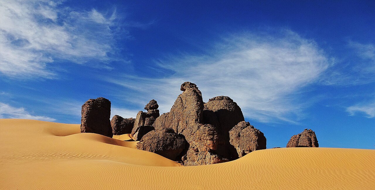
Tassili n’Ajjer is a vast sandstone plateau of 72,000 km² in southeastern Algeria, inscribed by UNESCO in 1982 as a mixed Cultural and Natural World Heritage Site. It holds one of the largest and most scientifically important concentrations of prehistoric rock art on Earth — more than 15,000 paintings and engravings that function as a visual chronicle of Saharan life from around 10,000 BCE to the historical period. The landscape itself is extraordinary: a labyrinth of eroded rock towers, natural arches, and canyon systems rising more than 1,000 metres above the surrounding desert.
A Stone Archive of the Sahara’s Green Past Southeastern Algeria, Illizi Province
The sequence of artistic styles at Tassili n’Ajjer documents something almost impossible to grasp from the current surface of the Sahara: a long, green past. The earliest images, from the Archaic or Bubalus period (c. 10,000–7,000 BCE), depict animals that no longer exist in North Africa — Saharan buffalo (Bubalus antiquus), elephants, hippopotamuses, giraffes, rhinoceroses, and crocodiles. Their presence is not artistic license. These species require abundant water and permanent vegetation. Their appearance in the paintings confirms that the central Sahara, during the African Humid Period, was a fertile savanna crossed by rivers and dotted with lakes. The so-called Green Sahara was real, and Tassili’s rock walls are among the most direct evidence for it.
The Round Head period (c. 7,000–5,000 BCE) follows with a striking stylistic shift: large, masked anthropomorphic figures with round, featureless heads and elaborate body decorations. These have been interpreted by researchers as representations of spirits or deities connected to shamanic ritual practice — the masks suggesting altered states of consciousness or cosmological beings rather than human portraits. Popular tabloid culture has long proposed extraterrestrial interpretations for the round-headed figures; archaeologists and art historians are unanimous in rejecting this reading, which misrepresents both the iconographic conventions of prehistoric African art and the well-documented global traditions of round-headed spirit figures in shamanic cultures across the world.
The Pastoral period (c. 7,500–1,500 BCE, overlapping with the preceding phase) is the richest and most diverse. It records cattle herders with their livestock, domestic scenes, and village life — the African Humid Period bringing regular monsoon rains that supported a mobile, cattle-keeping population across the central Sahara. The cattle themselves are depicted with enormous artistic care: individual animals shown in varied postures, with markings and colours rendered in ochre, white, and black mineral pigments still visible after thousands of years. The Horse and Chariot period (c. 1,500–200 BCE) reflects contact with Libyan and Garamantian cultures, showing chariots, horses, and warriors in a manner consistent with the known trade routes across the pre-desert. The Camel period (from c. 200 CE onward) marks the final desiccation of the Sahara and the shift to the ecology we recognise today.
Henri Lhote’s French expedition of 1956–57 produced the first systematic photographic and traced documentation of the paintings, and his 1958 book The Search for the Tassili Frescoes brought the site to international attention. His methods were of their time and would not be permitted today — tracings were made in direct contact with painted surfaces — but the documentation itself remains foundational for the field.
Rock Forest and the Most Isolated Tree on Earth Djanet oasis gateway, Illizi Province
The physical landscape of Tassili n’Ajjer is as remarkable as its art. The plateau is composed of Paleozoic sandstone laid down in horizontal beds, subsequently uplifted and cut by millennia of water erosion during wetter periods and by thermal fracturing during the extreme temperature swings of the desert. The result is a dense labyrinth of vertical columns, isolated towers, natural arches, and deep canyons — a landscape sometimes called a “stone forest” or forêt de pierres. Walking through it is genuinely disorienting: the rock towers rise 50 to 200 metres above the canyon floors, blocking sight-lines in all directions. The colours shift through the day from pale tan in midday light to deep amber and crimson at dusk.
Among the most arresting features of the plateau is the Cypress of Tassili (Cupressus dupreziana), a single prehistoric cypress tree standing on the plateau approximately 1,500 years old and estimated to be among the oldest trees in Africa. More striking than its age is its isolation: the nearest other trees of any species stand more than 100 kilometres away. It is frequently cited as the most isolated tree on Earth. The species itself (C. dupreziana) is now considered critically endangered with fewer than 230 mature individuals known — nearly all in this part of Algeria — and reproduces primarily through a process called male apomixis in which the embryo in a female tree’s seeds derives entirely from pollen genetics rather than the mother tree’s own genome.
Access to Tassili n’Ajjer begins at Djanet, a Tuareg oasis town in Illizi Province reachable by flights from Algiers and Tamanrasset. Algerian law requires all visitors to the plateau to be accompanied by a licensed Tuareg guide, both for safety — the plateau’s canyon systems are genuinely dangerous to navigate without knowledge of the terrain — and to support the local communities who are the custodians of the site. Tours are booked through tour operators based in Djanet, who arrange the mandatory guide, camping equipment, and the four-wheel-drive vehicles necessary to reach the plateau’s access points. The best visiting periods are October through April; summer temperatures on the plateau regularly exceed 45°C.
The sheer scale of the site — 72,000 km², roughly the size of Ireland — means that most visits cover only a fraction of the accessible paintings. The most frequently visited concentrations are in the Tadrart and Tamrit areas. Photography conditions are optimal in the early morning and late afternoon when low-angle light reveals the relief of the engravings.
Practical information
Getting there: Fly from Algiers (ALG) or Tamanrasset (TMR) to Djanet (DJG). Flight times are approximately 2 hours from Algiers. No road access from the north is recommended without a specialist desert expedition company; the Transsaharan Highway is not suitable for independent travel without extensive 4WD experience.
Guided tours: Compulsory. Book through licensed Djanet operators well in advance. A standard 4–5 day plateau trek with camping costs in the range of €300–€600 per person depending on group size and itinerary. Solo visits are not legally permitted.
Visas: Algeria requires visas for most nationalities. Applications are processed through Algerian embassies and can take several weeks; some nationalities face restrictions. Confirm requirements well in advance of travel.
Best season: October to April. The plateau is dangerously hot from May to September. Nights at altitude are cold even in spring and autumn; bring warm layers.
Physical demands: Moderate to strenuous. Access to many rock art panels requires scrambling over boulders and navigating narrow canyon passages. The altitude (up to 2,000m) adds to the exertion. No formal infrastructure (restaurants, hotels) exists on the plateau itself; all camping is tented.
Photography: Permitted for personal use. Flash photography near the paintings should be avoided. A photography permit may be required; confirm with your operator.
Frequently Asked Questions
What is the best way to see the rock art at Tassili n’Ajjer?
The most effective approach is a multi-day trekking camp on the plateau itself rather than a day trip from Djanet. The largest and most impressive concentrations of rock art — in the Tadrart area and the Tamrit cypress forest zone — require two to four days of walking from the plateau’s access points. Day trips from Djanet typically reach only peripheral sites near the plateau edge and miss the extraordinary interior canyon systems where the density of paintings and engravings is highest. A standard itinerary involves a 4WD transfer to the plateau rim, followed by trekking on foot with a Tuareg guide who carries or oversees camping equipment transported by camels or donkeys. The best rock art sites are found in the shelter of overhangs and cave mouths where the pigments have been protected from direct sun and rain. Your guide will know the precise locations; many are not documented on any publicly available map. Photography is best from dawn to mid-morning, when low-angle eastern light rakes across the engraved surfaces and reveals detail that flat midday light obscures. The most renowned individual site is Sefar, sometimes called a prehistoric “city” — a maze of rock towers and shelters with paintings in multiple superimposed layers representing different periods. Budget a full day for Sefar alone if it is on your itinerary.
How were the Tassili paintings made, and how have they survived?
The pigments used by the Tassili artists were mineral-based: ochres (iron oxides providing yellows, reds, and browns), charcoal and manganese dioxide for blacks, and white kaolin clay. These were ground to powder, mixed with a binder — animal fat, egg, blood, or water — and applied with fingers, feather ends, or simple brush-like tools made from plant fibres. Some of the oldest engravings were pecked or ground directly into the rock surface with harder stones, a technique known as petroglyphic incision. The survival of pigmented paintings after up to 12,000 years results from a combination of factors: the extreme aridity of the current Saharan climate, which halts bacterial and fungal degradation; the sheltered position of most painted surfaces under rock overhangs that protect them from rain and direct ultraviolet exposure; and the hardness of the sandstone matrix, which does not absorb moisture and shrink-swell in cycles that would crack the painted surface. The greatest threats today are not natural processes but human ones: graffiti, unauthorised touching of surfaces, and smoke from fires lit by earlier travellers in sheltered caves. The compulsory guide system exists partly to prevent these forms of damage.
Can I visit Tassili n’Ajjer independently, and is it safe?
Independent visits are not legally permitted under Algerian law. All tourists in the Tassili n’Ajjer National Park must be accompanied by a licensed guide, which in practice means booking through a registered tour operator based in Djanet. This requirement exists for two reasons: the genuine navigational danger of the plateau’s canyon systems, where it is easy to become disoriented and trapped without knowledge of the terrain, and the commitment of Algerian authorities to ensuring that the local Tuareg communities benefit economically from the site’s tourism. The broader security situation in southern Algeria has improved markedly since the early 2010s, when the region was affected by spillover from conflicts in Mali and Libya. As of the mid-2020s, the Djanet area and the Tassili plateau are considered low-risk for tourism, and Algerian authorities actively promote responsible visits. Nonetheless, travellers should check their government’s current travel advisory for Algeria before booking. The terrain itself is the primary safety concern: summer visits in particular pose a serious risk of heat exhaustion and dehydration, and even experienced desert trekkers have run into difficulty on the plateau in high summer. The October–April window is strongly recommended.
Sources
- S1 — Coulson, David, and Alec Campbell. African Rock Art: Paintings and Engravings on Stone. Harry N. Abrams, 2001. ISBN 978-0-8109-4363-6.
- S2 — Hachid, Malika. Les pierres écrites du Sahara: Le Tassili des Ajjer. Éditions Enag, 1998. ISBN 978-2-87772-152-3.
Spotted an error? Write to editorial@culturalheritageonline.com and we correct it the same day.
.jpeg)