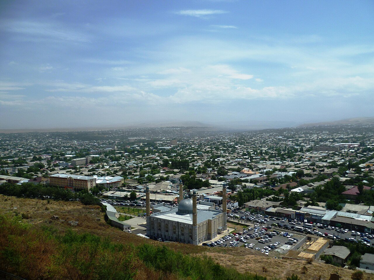
Sulaiman-Too Sacred Mountain rises 170 metres above the flat floor of the Fergana Valley in Osh, southern Kyrgyzstan’s oldest city, providing an abrupt rocky landmark that has been a focus of veneration for more than 3,000 years. Inscribed as a UNESCO World Heritage Site in 2009, the mountain carries 17,000 petroglyphs, 101 identified shrines and prayer spots, and a documented history that spans Bronze Age ritual through Silk Road commerce, Timurid architecture and active Islamic pilgrimage. It is the most fully preserved example of sacred mountain worship anywhere in Central Asia.
The mountain and its layers of use Osh city, southern Kyrgyzstan
The name Sulaiman-Too is Kyrgyz for “Solomon’s Mountain,” a designation that reflects the mountain’s absorption into Islamic tradition: the Prophet Sulaiman (Solomon in the Quran) is held in Islamic belief to have prayed here and, in some local traditions, to have died and been buried on its slopes. This identification made Sulaiman-Too one of the most important pilgrimage destinations in Central Asia within the Islamic world, a status it held through the medieval period and which it retains today. Pilgrims continue to climb to the summit and visit the shrines cut into the rock face throughout the year.
The mountain has five distinct peaks visible from across the city of Osh, which has a current population of approximately 300,000 and is Kyrgyzstan’s second largest city after Bishkek. The rock is a coarse-grained conglomerate; its bare, light-coloured surfaces stand out sharply against the surrounding alluvial plain and the tree cover of the city. From the summit there is a clear 360-degree view of the Fergana Valley — the most densely populated lowland in Central Asia, shared today between Kyrgyzstan, Uzbekistan and Tajikistan.
The petroglyphs number at least 17,000 identified images and represent the single largest concentration of carved rock imagery in Kyrgyzstan. They span an extraordinary time range. The earliest images — animals, hunting scenes, hand outlines — date from the Bronze Age (approximately 2000–700 BCE). Scythian and Saka period images (roughly 700–200 BCE) add further animal figures in a style consistent with the “Animal Style” art characteristic of the Eurasian steppe nomads. Later additions include Sogdian merchant graffiti from the Silk Road period, when Osh functioned as a significant trading stop on the routes connecting China with Persia and the Mediterranean; Timurid decorative inscriptions in Arabic and Persian; and more recent pilgrim markings extending up to the modern period.
The 101 shrines and sacred spots documented on the mountain include prayer niches carved into the rock, meditation caves used by ascetics, and specific rock surfaces associated with particular requests or conditions. Among the most actively used is a smooth, hollow depression in the rock known as Takhti Sulaiman — “Solomon’s Throne” — down which women seeking fertility traditionally slide. This practice, continuous over many generations, has worn the stone surface to a remarkable smoothness. The combination of Bronze Age petroglyphs, Islamic shrines and active folk-religious practice on a single geological feature over a continuous period is what UNESCO described as making the site “the most complete example of this type of ancient sacred mountain worship in Central Asia.”
Babur, the Timurid mosque and the Silk Road city below Fergana Valley, near Uzbekistan border
Among the historical figures associated with Sulaiman-Too, the most specific documentary record belongs to Zahir ud-Din Muhammad Babur (1483–1530). Born at Andijan in the Fergana Valley — now eastern Uzbekistan, a short distance from Osh — Babur was a Timurid prince who spent the early decades of his life attempting to hold and expand his Central Asian territories before his conquests in the Indian subcontinent led to the founding of the Mughal Empire. In his memoirs, the Baburnama — one of the most remarkable autobiographical texts of the pre-modern world — Babur described Sulaiman-Too with evident personal attachment, noting its visibility from across the valley and the experience of praying at its summit.
In 1496, Babur built a small prayer house on the mountain’s south face. The structure that stands there today is a reconstruction completed in 1991; the original was destroyed in 1963 by an explosion which Soviet authorities described as accidental but which local tradition attributes to deliberate demolition as part of the anti-religious campaigns of the Khrushchev era. The reconstructed mosque, built in a simplified version of the Timurid style characteristic of 15th-century Central Asian religious architecture, contains a small museum and offers views over the city from a position partway up the south slope.
The Osh State Museum of Local History is embedded directly into the rock of the north face of Sulaiman-Too, its entrance carved into the cliff. The museum holds archaeological material from the Osh region and interpretive displays relating to the site’s history and the petroglyph traditions. Osh itself preserves a central bazaar — one of the largest traditional markets in Central Asia — along with a number of Soviet-era monuments and older Islamic architectural remains. The city’s position near the Kyrgyzstan-Uzbekistan border means it has historically been a meeting point of Turkic, Persian and Slavic cultural influences.
Osh is accessible from the Kyrgyz capital Bishkek by a one-hour scheduled flight on the Kyrgyz airlines, or by road via one of two mountain passes — the Torugart or Irkeshtam routes add considerable distance, while the direct road through the Tian Shan mountains takes nine to twelve hours depending on conditions. The road journey is scenically significant, crossing some of the most dramatic alpine terrain in Central Asia, but the altitude and road condition should be factored into planning, particularly outside the summer months.
Practical information
Sulaiman-Too Sacred Mountain is located in the centre of Osh city, Jalal-Abad Region (administratively Osh City), southern Kyrgyzstan. GPS coordinates: approximately 40°31′N 72°47′E. The mountain is accessible on foot from the city centre; multiple paths lead to the summit and to the south-face mosque. The Osh State Museum of Local History on the mountain’s north face has fixed opening hours and charges an entrance fee; access to the mountain itself and its shrines is open. The nearest airports are Osh International Airport (domestic flights from Bishkek, approximately 1 hour) and, for international connections, Bishkek Manas International Airport. No visa is currently required for citizens of many countries visiting Kyrgyzstan for stays under 30 days, but this should be verified before travel. Currency is the Kyrgyz som; ATMs are available in Osh city centre. The Fergana Valley can be extremely hot in summer (July–August temperatures regularly exceed 35°C); spring (April–May) and autumn (September–October) are more comfortable for climbing the mountain.
Frequently Asked Questions
Why is the mountain called Solomon’s Mountain, and what is the connection to Islamic tradition?
The name Sulaiman-Too — “Solomon’s Mountain” in Kyrgyz — derives from the identification of this peak with the Prophet Sulaiman, the Islamic name for the biblical King Solomon. In the Quran, Sulaiman is a major prophet credited with extraordinary powers including the ability to command winds, animals and spirits. The association of a pre-existing sacred site with a Quranic prophet is a pattern found across the Islamic world: as Islam spread into Central Asia from the 7th century onwards, mountains, springs and caves that already carried spiritual significance in local tradition were frequently absorbed into the Islamic sacred landscape by being associated with Quranic figures or early Muslim saints. At Osh, the mountain’s dramatic visual prominence above the Fergana Valley, combined with its pre-existing history of ritual use extending back to the Bronze Age, made it a natural candidate for such association. Local tradition holds that Sulaiman both prayed on the mountain and was buried there — the latter claim is disputed by mainstream Islamic theology, which places Solomon’s tomb in Jerusalem, but the local tradition is sincerely maintained and shapes the character of pilgrimage at the site. The mountain’s status as a pilgrimage destination is therefore layered: it carries Islamic significance for devout Muslim visitors, historical significance for those tracing Babur’s life, and archaeological significance for the petroglyphs that predate Islam in the region by more than two millennia.
What are the petroglyphs at Sulaiman-Too, and who made them?
The 17,000 petroglyphs at Sulaiman-Too were made by multiple cultures over a period spanning at least 3,500 years, making the site an accumulative archive rather than the product of a single artistic tradition. The earliest images date from the Bronze Age (approximately 2000–700 BCE) and include ibex, deer, hunting scenes and human figures in a style broadly consistent with other Bronze Age rock art found across the Eurasian steppe and the mountains of Central Asia. The Saka/Scythian period (roughly 700–200 BCE) contributed further animal figures, particularly horses and deer, in a dynamic style related to the metalwork art of the steppe nomads. The Silk Road period added a different kind of mark: Sogdian merchants, who dominated long-distance trade between China and the Mediterranean from roughly the 4th to 8th centuries CE, left graffiti on the rock in their script — inscriptions recording names, dates and commercial transactions rather than images. Later Timurid rulers and their contemporaries added calligraphic inscriptions in Arabic and Persian. More recent markings extend into the 19th and 20th centuries. The mountain’s surface is therefore readable as a compressed account of the cultures that passed through the Fergana Valley over three and a half millennia — nomadic pastoralists, steppe warriors, overland merchants, Islamic scholars and Timurid aristocrats all left their marks on the same rock.
What is the Baburnama, and what does Babur say about Sulaiman-Too?
The Baburnama (formally titled Tuzk-i-Baburi, “Babur’s Institutes”) is the autobiographical memoir of Zahir ud-Din Muhammad Babur, written in Chagatai Turkic, the literary language of the Timurid court. It is considered one of the most significant prose works in the Turkic literary tradition and one of the earliest true autobiographies in Islamic literature — a genre that was uncommon in the pre-modern world. Babur began writing it in the 1490s and continued through his campaigns in Afghanistan and India; the text covers his childhood in the Fergana Valley, his years of territorial struggle in Central Asia, his conquest of Kabul, and his later conquest of the Delhi Sultanate, which became the Mughal Empire. The Baburnama is valued both as a literary text and as a historical source: Babur writes with unusual directness and specificity, recording not only military campaigns but personal observations on landscapes, plants, animals, foods and people. His descriptions of the Fergana Valley and the area around Osh are among the most detailed historical accounts of that region from the 15th century. Regarding Sulaiman-Too, Babur noted the mountain’s visibility from across the valley and its use as a place of prayer; he described building his small prayer house on the south face in 1496, an act that placed him personally in the site’s long history of veneration. The prayer house he built was later used as a point of reference by subsequent rulers and travellers, and its reconstruction in 1991 maintains the physical connection to his account.